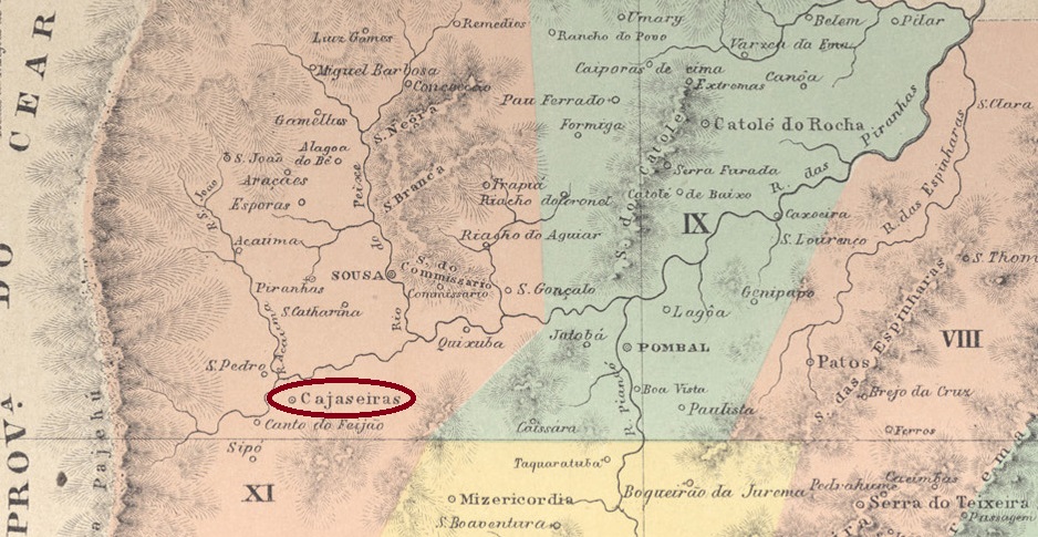
Cajazeiras was the name of an 18th century fazenda located 480 km west of the later provincial capital of Parahyba (now João Pessoa) near the border with Ceará. The settlement that developed there became the Freguesia de N. Sra. da Piedade de Cajazeiras, which was part of the Vila de Sousa, in August 1859, a Vila in November 1863 and a town in July 1876.
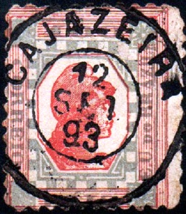
As Nova Monteiro writes in Administrações e Agencias Postaes do Brasil Imperio (Brasil Filatelico/RJ, 1934-5; Reprint SPP 1994-1999), there was a post office there since September 1867. Reinhold Koester mentions in Carimbologia VII a postmark as a simple double circle with the inscription CAJAZEIRA, dated 1893, which should correspond to this image provided by Luís C. Fritzen, as CPB-0095b:
CPB-0095b (LCF) 1893Villiers de l’Ile Adam: Carta (…) das Provincias do Rio Grande do Nortee Parahiba, 1848
Textaktualisierung am 10. August 2023
Cajazeiras war der Name einer Fazenda aus dem 18. Jahrhundert, die 480 km westlich der späteren Provinzhauptstadt Parahyba (heute João Pessoa) nahe der Grenze zu Ceará lag. Die dort entstandene Siedlung wurde im August 1859 zur Freguesia de N. Sra. da Piedade de Cajazeiras, die zur Vila de Sousa gehörte, im November 1863 zur Vila und im Juli 1876 zur Stadt.
Wie Nova Monteiro in Administrações e Agencias Postaes do Brasil Imperio (Brasil Filatelico/RJ, 1934-5; Reprint SPP 1994-1999) schreibt, gab es dort seit September 1867 ein Postamt. Reinhold Koester erwähnt in Carimbologia VII einen Stempel als einfachen Doppelkreis mit der Aufschrift CAJAZEIRA, datiert 1893, der diesem von Luís C. Fritzen zur Verfügung gestellten Bild als CPB-0095b entsprechen dürfte:
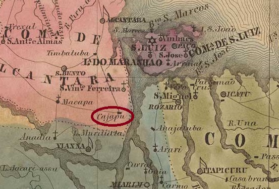
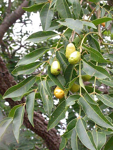
The village was originally an arraial of the Vila de S. Bento dos Perizes on the west bank of the Mearim, 160 km southwest of the provincial capital São Luís do Maranhão. It was elevated to vila status in May 1876 and to town status in April 1924. Cajapió was then downgraded to district and passed to the Município S. Vicente Ferrer in January 1932 and to S. Bento dos Perizes in December 1933, before being promoted again to Município in June 1935. The indigenous word cajapió means ripe cajá fruit. It is the yellow mombin plum (Spondias mombin, L.) from the Anacardiaceae family:
Wikipedia (Photo: Marco Schmidt, CC BY-SA 2.5)
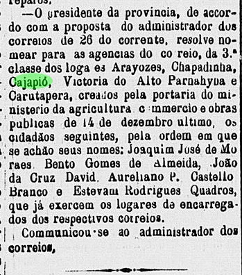
According to the regional press, there was a post office here from December 1882:
Publicador Maranhense, 01.02.1883
So far, no imperial postmark from Cajapió has been seen.
Villiers de l’Ile Adam: Carta (…) da Provincia do Maranhão, 1850
Der Ort war ursprünglich ein Arraial der Vila de S. Bento dos Perizes am Westufer des Mearim, 160 km südwestlich der Provinzhauptstadt São Luís do Maranhão. Im Mai 1876 wurde es zur Vila und im April 1924 zur Stadt erhoben. Danach wurde Cajapió zum Distrikt herabgestuft und ging als solcher im Januar 1932 zum Município S. Vicente Ferrer und im Dezember 1933 zu S. Bento dos Perizes, bevor der Wiederaufstieg zum Município im Juni 1935 erfolgte. Das indigene Wort Cajapió bedeutet reife Cajá-Frucht. Es handelt sich um die Gelbe Mombinpflaume (Spondias mombin, L.) aus der Familie der Anacardiaceae:
Wikipedia (Foto: Marco Schmidt, CC BY-SA 2.5)
Wie aus der regionalen Presse hervorgeht, gab es hier ab Dezember 1882 ein Postamt:
Publicador Maranhense, 01.02.1883
Bislang war kein kaiserlicher Poststempel aus Cajapió zu sehen.
Villiers de l’Ile Adam: Carta (…) das Provincias do Grão Pará e Alto Amazonas, 1850
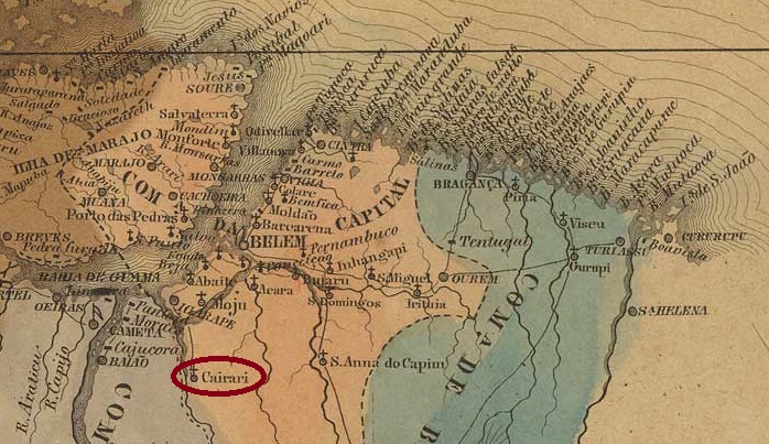
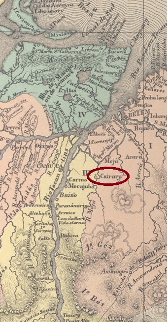
The chapel of Nossa Senhora da Soledade de Cairary was built in August 1856 on the north bank of the Moju River, 260 km south of the provincial capital Belém do Pará. It initially belonged to the Vila of Moju but passed as a freguesia to the Município of Igarapé-Miry three times (September 1869, November 1887, and December 1930) and was also a district of Belém (November 1930), but always returned to the Município of Moju: October 1870, October 1889 and most recently in October 1935, now written as a district, Cairari.
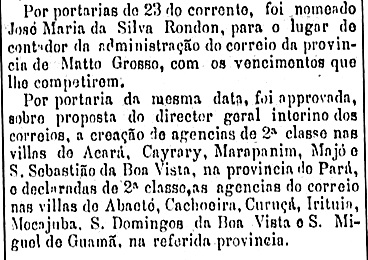
As can be seen from the Rio press, there had been a post office there since March 1882:
O Globo/RJ, 24.03.1882
No imperial postmark from Cairari has yet been seen.
Atlas do Imperio do Brasil, 1868
Die Kapelle Nossa Senhora da Soledade de Cairary wurde im August 1856 am Nordufer des Flusses Moju, 260 km südlich der Provinzhauptstadt Belém do Pará, errichtet. Sie gehörte zunächst zur Vila von Moju, ging aber als Freguesia dreimal an das Município von Igarapé-Miry (September 1869, November 1887 und Dezember 1930) und war auch ein Distrikt von Belém (November 1930), kehrte aber immer wieder zum Município von Moju zurück: Oktober 1870, Oktober 1889 und zuletzt im Oktober 1935, nun als Distrikt, Cairari geschrieben.
Wie aus der Presse von Rio hervorgeht, gab es dort seit März 1882 ein Postamt:
O Globo/RJ, 24.03.1882
Bisher wurde noch kein kaiserlicher Poststempel aus Cairary gesehen.
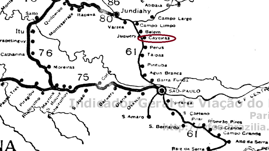
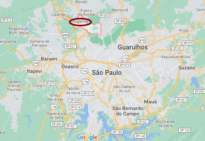
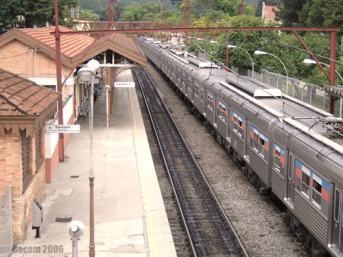
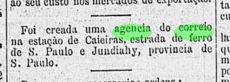
Caieiras station was inaugurated by the São Paulo Railway (Main Line) in July 1883 and is located on the east bank of the Juqueri in the Município Guarulhos, just under 40 km north of the provincial capital São Paulo. The area around the station passed to the Município Juqueri in March 1889 and became a district in November 1838. Six years later the district was assigned to the Município Franco da Rocha and since February 1959 Caieiras has been an independent Município.
The railway line passed to the E.F. de Santos a Jundiaí in 1946 and to the Rede Ferroviária Federal S.A. (estacoesferroviarias.com.br) in 1975. Since 1994, the line has been operated by Cia. Paulista de Transportes Metropolitanos.
2006 (estacoesferroviarias.com.br)
The Rio press reports that there had been a station post office since August 1889:
Gazeta de Noticias/RJ, 31/08/1889
No imperial postmark has yet been seen from Caieiras station, it must be very rare.
Google Maps
Der Bahnhof Caieiras wurde im Juli 1883 von der São Paulo Railway (Hauptlinie) eingeweiht und liegt am Ostufer des Juqueri im Município Guarulhos, knapp 40 km nördlich der Provinzhauptstadt São Paulo. Das Gebiet um den Bahnhof ging im März 1889 zum Município Juqueri über und wurde im November 1838 zu einem Distrikt. 6 Jahre später wurde der Distrikt dem Município Franco da Rocha zugeordnet und seit Februar 1959 ist Caieiras ein eigenständiger Município.
Die Eisenbahnlinie ging 1946 an die E.F. de Santos a Jundiaí und 1975 an die Rede Ferroviária Federal S.A. (estacoesferroviarias.com.br) über. Seit 1994 wird die Strecke von der Cia. Paulista de Transportes Metropolitanos.
2006 (estacoesferroviarias.com.br)
Die Presse von Rio berichtet, dass es seit August 1889 ein Bahnhofspostamt gab:
Gazeta de Noticias/RJ, 31.08.1889
Bisher wurde noch kein kaiserlicher Poststempel vom Bahnhof Caieiras gesehen, er muss sehr selten sein.
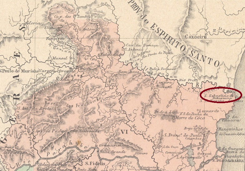
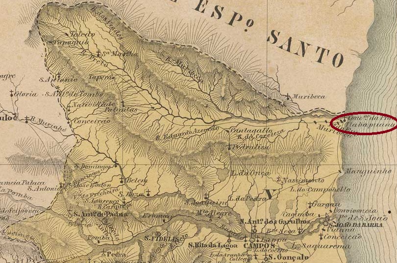
Other names: S. Sebastião de Itabapoana, Itabapoana
São Sebastião de Itabapoana was a small arraial on the south bank of the mouth of the Itabapoana on the provincial border between Rio de Janeiro and Espírito Santo, 360 km northeast of the capital Rio de Janeiro. In October 1857, it became a freguesia in the newly founded Município de S. João da Barra. Since January 1995 it has been the district of Itabapoana in the Município S. Francisco do Itabapoana.
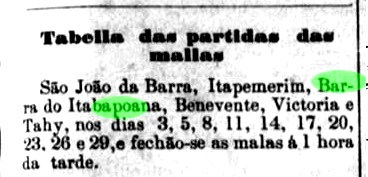
Two creation dates have been found for the local post office. Paulo Novaes writes in agenciaspostais.com.br “ca. 1885”, while in the Directory of Imperial Post Offices (Tabella das Agencias do Correio do Imperio, Rio de Janeiro, 1885) the year is 1879, which is confirmed by a note in the regional press about 10 postal connections per month between Campos and Barra do Itabapoana:
Monitor Campista, 18.06.1879
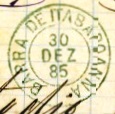
The imperial postmark is the double circle BRJ-0120a (Fig. D. Feldman Auction) with the inscription BARRA DE ITABAPOANNA and internal dates from 1885 to 1899.
BRJ-0120a (DF)Villiers de l’Ile Adam: Carta (…) da Provincia do Rio de Janeiro, 1850
Andere Namen: S. Sebastião de Itabapoana, Itabapoana
São Sebastião de Itabapoanna war ein kleiner Arraial am Südufer der Mündung des Itabapoana an der Provinzgrenze zwischen Rio de Janeiro und Espírito Santo, 360 km nordöstlich der Hauptstadt Rio de Janeiro. Im Oktober 1857 wurde es eine Freguesia im neu gegründeten Município de S. João da Barra. Seit Januar 1995 ist es der Bezirk Itabapoana im Município S. Francisco do Itabapoana.
Für das örtliche Postamt wurden zwei Gründungsdaten ermittelt. Paulo Novaes schreibt in agenciaspostais.com.br „ca. 1885“, während im Verzeichnis der kaiserlichen Postämter (Tabella das Agencias do Correio do Imperio, Rio de Janeiro, 1885) das Jahr 1879 zu lesen ist, was durch einen Bericht der regionalen Presse über 10 Postverbindungen pro Monat zwischen Campos und Barra do Itabapoana bestätigt wird:
Monitor Campista, 18.06.1879
Der kaiserliche Poststempel ist der Doppelkreis BRJ-0120a (Abb. D. Feldman Auktion) mit der Inschrift BARRA DE ITABAPOANNA und internen Daten von 1885 bis 1899.
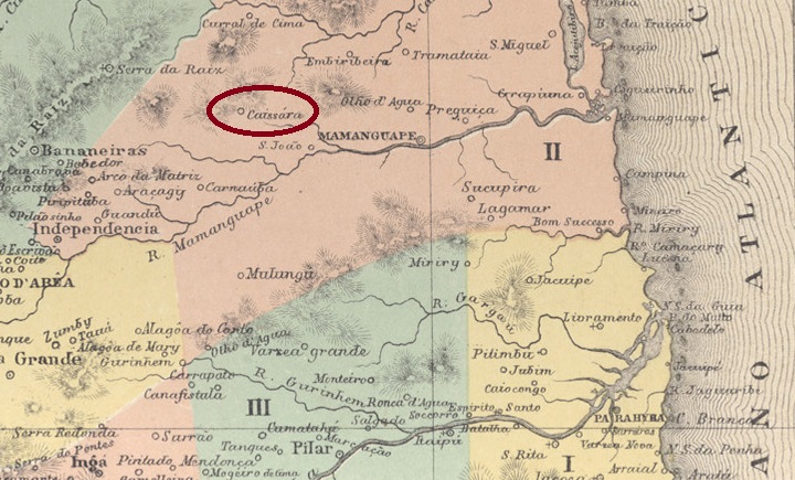
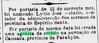
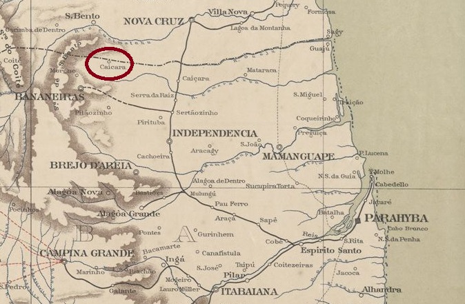
The beautiful Indian word Caiçara (formerly also spelled Caissara) means fisherman’s hut and can still be heard all over Brazil by the sea or rivers. The Arraial of N. Sra. do Rosário de Caiçara was founded around 1841, belonged to the Vila of Serra da Raiz and was located on the banks of the Curimataú, 130 km northwest of the provincial capital Parahyba do Norte (today: João Pessoa). The village was elevated to the status of a vila in December 1883, but passed to the Município Guarabira as a freguesia as early as October of the following year and was not elevated to the status of an independent município again until November 1908.
As was learned from the Rio press, there had been a post office there since May 1884:
Brazil/RJ 15.05.1884
However, this was moved to the neighbouring Serra da Raiz in October 1885, as R. Koester writes in Carimbologia VII, and was not reopened until July 1893. Imperial postmarks from Caiçara have not been seen so far.
Serviço Geologico e Mineralogico, 1910
Das schöne indianische Wort Caiçara (früher auch Caissara geschrieben) bedeutet Fischerhütte und ist noch heute in ganz Brasilien am Meer oder an Flüssen zu hören. Der Arraial von N. Sra. do Rosário de Caiçara entstand um 1841, gehörte zur Vila von Serra da Raiz und lag am Ufer des Curimataú, 130 km nordwestlich der Provinzhauptstadt Parahyba do Norte (heute: João Pessoa). Der Ort wurde im Dezember 1883 zur Vila erhoben, ging aber bereits im Oktober des folgenden Jahres als Freguesia zum Município Guarabira und wurde erst im November 1908 wieder zum eigenständigen Município erhoben.
Wie aus der Presse von Rio zu erfahren war, gab es dort seit Mai 1884 ein Postamt:
Brazil/RJ 15.05.1884
Dieses wurde jedoch im Oktober 1885 in die benachbarte Serra da Raiz verlegt, wie R. Koester in Carimbologia VII schreibt, und erst im Juli 1893 wiedereröffnet. Kaiserliche Poststempel aus Caiçara wurden bisher nicht gesichtet.
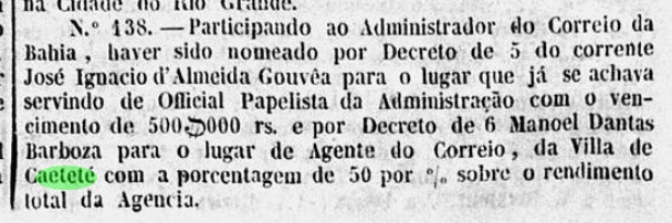
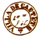
See also: Villa de Caetete (VBA-0880); Vila Nova do Principe (RK XXXII)
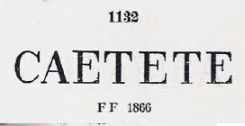
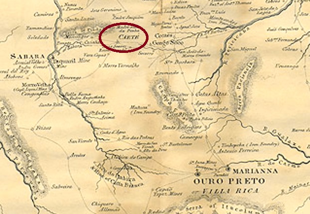
The freguesia called “Villa” Nova do Principe was mentioned in documents as early as 1754 and was located on the west bank of the São João River, 630 km southwest of the provincial capital Salvador da Bahia. A royal decree (Decreto Real) from February 1810 declared the place a vila, which rose to the town of Sant’Anna de Caeteté in October 1867, now written Caetité. The Tupi word means forest with large stones.
Two creation dates for the local post office were found. In Administrações e Agencias Postaes do Brasil Imperio (Brasil Filatelico/RJ, 1934-5; Reprint SPP 1994-1999), Nova Monteiro writes August 1841, while Reinhold Koester notes May 1865 in his Carimbologia. If Nova Monteiro’s information is correct, there was probably a pre-philatelic postmark from Villa Nova do Principe. However, the agency was already officially called Caeteté in November 1846:
Gazeta Official/RJ, 25.11.1846
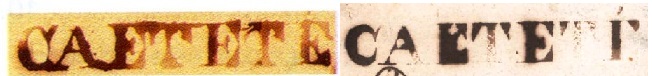
So far, no postmark with Villa Nova do Principe has been seen. The first stamp with the new place name is CBA-0200a, which is listed in Paulo Ayres’ Catálogo de Carimbos Brasil-Império (S. Paulo, 1937, 1942) under no. 1132. However, its illustration shows considerable differences from the original (here fig. RHM catalogue):
It was followed by VBA-0880a, which is illustrated in the RHM catalogue and was in circulation from about 1843 to 1847:
VBA-0880a (RHM)
In the meantime, another postmark has also appeared in the Fuad Ferreira Fo. collection. CBA-0200b is a previously unknown French type:
CBA-0200b (FF) ca. 1882
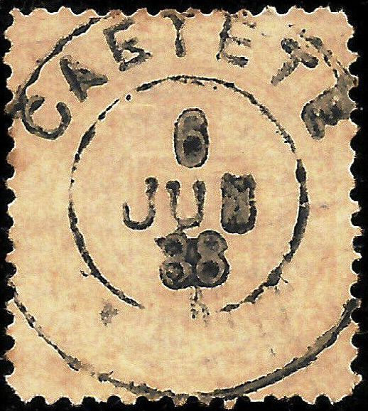
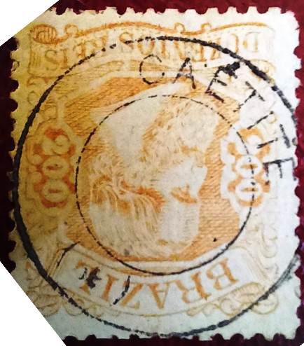
The plain double circle CBA-0200c (collect. FM) bears the dates 1882ff-1890 in the centre:
CBA-0200c (FM) 1882ff-1890
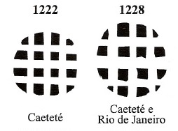
Finally, James Dingler and Klerman W. Lopes have listed two mute cancellations from Caetité in Mute Cancellations of the Brazil Empire/ Carimbos Mudos do Brasil Império (Brazil Philatelic Association, Rio de Janeiro, 2000):
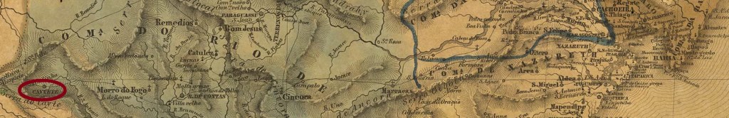
BPA 1222, 1228Villiers de l’Ile Adam: Carta (…) da Provincia da Bahia, 1848
Textaktualisierung am 15. August 2023
Siehe auch: Villa de Caetete (VBA-0880); Vila Nova do Principe (RK XXXII)
Die Freguesia namens “Villa” Nova do Principe wurde bereits 1754 urkundlich erwähnt und lag am Westufer des Flusses São João, 630 km südwestlich der Provinzhauptstadt Salvador da Bahia entfernt. Ein königliches Dekret (Decreto Real) aus Februar 1810 hob den Ort zu einer Vila auf, die im Oktober 1867 zur Stadt Sant’Anna de Caeteté aufstieg, heute Caetité geschrieben. Das Wort der Tupi-Sprache bedeutet Wald mit großen Steinen.
Zwei Gründungsdaten fürs örtliche Postamt wurden gefunden. Nova Monteiro schreibt dafür in Administrações e Agencias Postaes do Brasil Imperio (Brasil Filatelico/RJ, 1934-5; Reprint SPP 1994-1999) den August 1841, während Reinhold Koester den Mai 1865 notiert. Wenn Nova Monteiros Angabe stimmt, gab es vermutlich einen Präphila-Poststempel aus Villa Nova do Principe. Allerdings wurde die Agentur bereits im November 1846 Caeteté offiziell genannt:
Gazeta Official/RJ, 25.11.1846
Bisher war kein Poststempel mit Villa Nova do Principe zu sehen. Der erste Stempel mit dem neuen Ortsnamen ist CBA-0200a, der in Paulo Ayres‘ Catálogo de Carimbos Brasil-Império (S. Paulo, 1937, 1942) unter der Nr. 1132 verzeichnet ist. Seine Abbildung weist jedoch erhebliche Unterschiede zum Original auf (hier Abb. RHM-Katalog):
Ihm folgte VBA-0880a. Er ist im RHM-Katalog abgebildet und war von ca. 1843 bis 1847 im Umlauf:
VBA-0880a (RHM)
Inzwischen ist auch ein weiterer Poststempel in der Sammlung Fuad Ferreira Fo. aufgetaucht. CBA-0200b ist ein bisher unbekannter, französischer Typ:
CBA-0200b (FF) ca. 1882
Der einfache Doppelkreis CBA-0200c (Samml. FM) trägt in der Mitte die Jahreszahlen 1882ff-1890:
CBA-0200c (FM) 1882ff-1890
James Dingler und Klerman W. Lopes haben schließlich in Mute Cancellations of the Brazil Empire/ Carimbos Mudos do Brasil Império (Brazil Philatelic Association, Rio de Janeiro, 2000) zwei stumme Entwertungen aus Caetité aufgelistet:
The old settlement of Villa Nova da Rainha was already mentioned in a document in January 1714 and was located near Sabará, 120 km north of the later provincial capital Ouro Preto. After Brazil’s independence in 1822, the place name had to be changed. Thus, the Freguesia of N. Sra. do Bom Successo do Caethé came into being in June 1833 and was made a town in November 1865.
Two dates have been found for the creation of the local post office. First in March 1829, as Nova Monteiro writes in Administrações e Agencias Postaes do Brasil Imperio (Brasil Filatelico/RJ, 1934-5; reprint SPP 1994-1999). On the other hand, Paula Sobrinho in História Postal de Minas Gerais (Belo Horizonte, 1997) records October 1833. Should Nova Monteiro be right with his earlier date, postmarks with Villa Nova da Rainha would be quite possible. However, none of them have appeared so far. On the other hand, the presence of VMG-0451a in documents and letters between 1840 and 1843 is well documented, as its illustration in the RHM catalogue also shows:
VMG-0451a (RHM P-MG-10)
The first postmark with the abbreviated place name Caeté is the French type CMG-0450b, which also exists in red and yellow, as can be seen in R. Koester’s Carimbologia VII:
CMG-0450b (RK) 1880-1889
It was followed by the double circle CMG-0450c (picture from the internet):
CMG-0450c (EB) 1889-1893
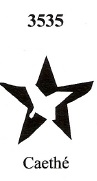
James Dingler and Klerman W. Lopes have also registered a mute cancel from Caethé under no. 3535 in Mute Cancellations of the Brazil Empire / Carimbos Mudos do Brasil Império (Brazil Philatelic Association, Rio de Janeiro, 2000):
BPA 3535 (P.A. 729), 1884ff-1886Villiers de l’Ile Adam: Carta (…) da Provincia de Minas Geraes, 1849
Anderer Name: Villa Nova da Rainha
Siehe auch Villa de Caethe (VMG-0451)
Die alte Siedlung von Villa Nova da Rainha wurde bereits im Januar 1714 urkundlich erwähnt und lag bei Sabará, 120 km nördlich der späteren Provinzhauptstadt Ouro Preto entfernt. Nach der Unabhängigkeit Brasiliens 1822 musste der Ortsname geändert werden. So entstand im Juni 1833 die Freguesia von Na. Sra. do Bom Successo do Caethe, die im November 1865 zur Stadt ernannt wurde.
Zwei Daten für die Entstehung des lokalen Postamts wurden gefunden. Erstmals im März 1829, wie Nova Monteiro in Administrações e Agencias Postaes do Brasil Imperio (Brasil Filatelico/RJ, 1934-5; Reprint SPP 1994-1999) schreibt. Dagegen registriert Paula Sobrinho in História Postal de Minas Gerais (Belo Horizonte, 1997) den Oktober 1833. Sollte Nova Monteiro mit seinem früheren Termin Recht haben, wäre die Existenz von Poststempeln mit Villa Nova da Rainha gut möglich. Allerdings ist bisher keiner davon aufgetaucht. Dagegen ist das Vorhandensein von VMG-0451a in Dokumenten und Briefen zwischen 1840 und 1843 gut belegt, wie auch seine Abbildung im RHM-Katalog zeigt:
VMG-0451a (RHM P-MG-10)
Der erste Poststempel mit dem abgekürzten Ortsnamen Caeté ist der französische Typ CMG-0450b, den es auch in rot und gelb gibt, wie in R. Koesters Carimbologia VII zu sehen ist:
CMG-0450b (RK) 1880-1889
Ihm folgte der Doppelkreis CMG-0450c (Bild aus dem Internet):
CMG-0450c (EB) 1889-1893
James Dingler und Klerman W. Lopes haben in Mute Cancellations of the Brazil Empire / Carimbos Mudos do Brasil Império (Brazil Philatelic Association, Rio de Janeiro, 2000) auch einen stummen Stempel aus Caethé unter Nr. 3535 registriert:
Villiers de l’Ile Adam: Carta (…) da Provincia de São Paulo, 1847
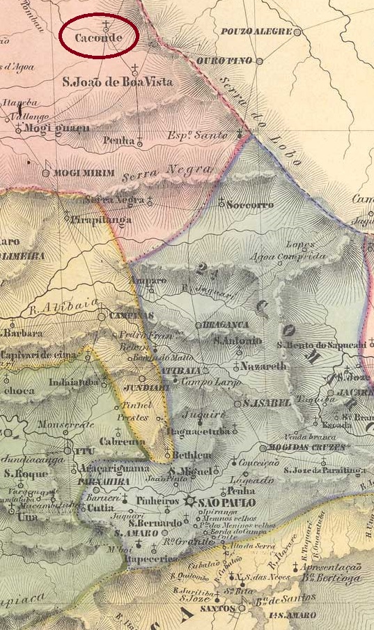
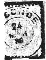
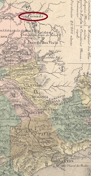
The Freguesia of N. Sra. da Conceição de Caconde was founded in 1775, belonged to the Vila of Mogy-Mirim and was located 300 km north of the later provincial capital of São Paulo. In February 1841, the village changed as a freguesia to the Município of Casa Branca, became an independent Vila in April 1844 and a town in March 1883.
According to the Rio Press, there was a post office there from April 1865:
Correio Mercantil/RJ, 30.04.1865
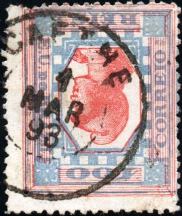
The only 19th century postmark so far is CSP-0220b. Here the image from R. Koester’s Carimbologia VII:
CSP-0220b (RK) 1886-1894ffAtlas do Imperio do Brasil, 1868
Die Freguesia von N. Sra. da Conceição de Caconde wurde 1775 gegründet, gehörte der Vila von Mogy-Mirim und lag 300 km nördlich der späteren Provinzhauptstadt São Paulo. Im Februar 1841 wechselte die Ortschaft als Freguesia zum Município von Casa Branca, wurde im April 1844 eine eigenständige Vila und im März 1883 eine Stadt.
Wie aus der Rio-Presse hervorgeht, gab es dort ein Postamt ab April 1865:
Correio Mercantil/RJ, 30.04.1865
Der bisher einzige Poststempel aus dem 19. Jahrhundert ist CSP-0220b. Hier die Abbildung aus Koesters Carimbologia VII:
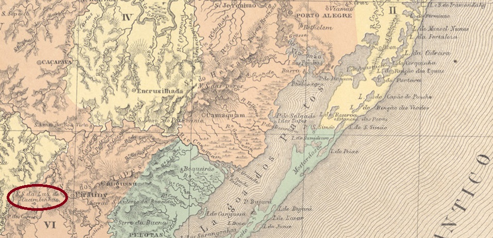
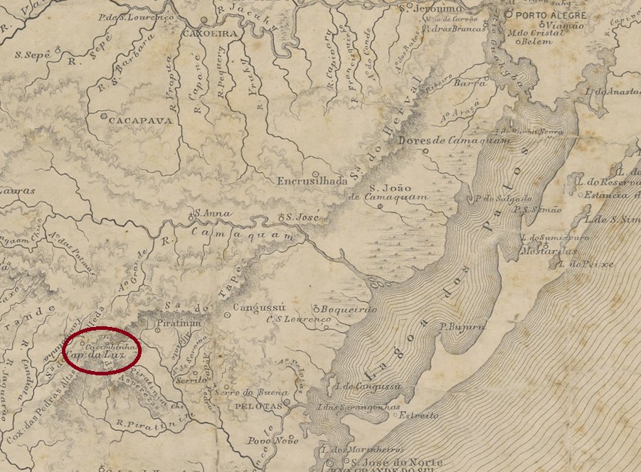
Portuguese settlement in the region began around 1765 by families from the Azores and the village initially belonged to the vila of Rio Grande. One of the first fazendeiros was José Dutra de Andrade. A local legend tells that he went blind for unknown reasons. In his despair, he washed only with water from the local watering holes (cacimbas). And lo and behold, he was soon able to see again and, out of gratitude, had a chapel built in honour of Nossa Senhora da Luz (“Our Lady of Light”).
N. Sra. da Luz de Cacimbinhas became curato, i.e. parish, in November 1851, now in the Município Piratini. In January 1857, the village was elevated to freguesia status and in May 1878 was granted political autonomy as a villa in its own município.
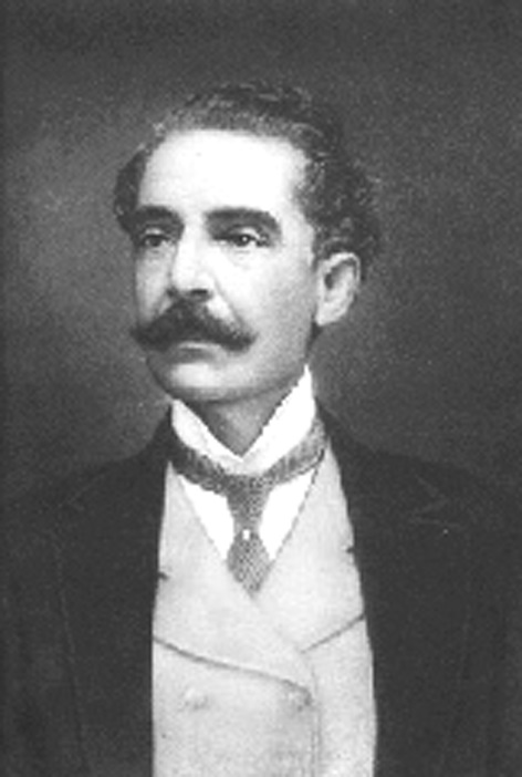
On 8 September 1915, in a luxury hotel in Rio de Janeiro, the influential senator José Gomes Pinheiro Machado, who was a grey eminence of the early republic, died by a stab in the back:
Pinheiro Machado (1851-1915)
His murderer was the Cacimbinhas-born political activist Francisco Manço de Paiva Coimbra. As a result, the designated Intendente (mayor) of Cacimbinhas ordered the renaming of the municipality that same month, and it has been called Pinheiro Machado ever since.
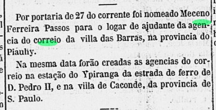
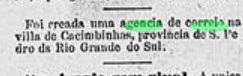
As can be seen from the Directory of Imperial Post Offices (Tabella das Agencias do Correio do Imperio, Rio de Janeiro, 1885), there had been a post office there since 1880, but in March of the following year, the Rio press again announced the creation of the agency:
Gazeta de Noticias/RJ, 04.03.1881
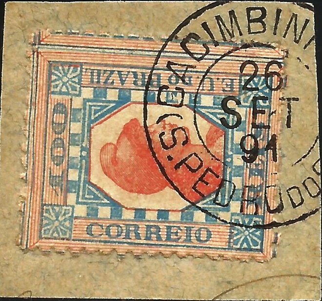
R. Koester describes the first postmark CRS-0060a as a double circle with the dates 1886 and 1887 in the centre. Its successor CRS-0060b (ill. Claudio Coelho) is a circle cancel in negative form with the inscriptions CACIMBINHA (sic) at the top and S.P. DO SUL between five-pointed stars at the bottom. The date in the centre is missing and the stamp has so far been found on issues from 1890.
The cancel CRS-0060c has already been presented by Paulo Ayres in Catálogo de Carimbos Brasil-Império (S. Paulo, 1937, 1942):
CRS-0060c (P.A. p.145)
The last postmark of the 19th century could already be Republican, as CRS-0060d (Fig. Felipe Piccinini) presents dates from 1891-1894:
CRS-0060d (FP) 1891-1894
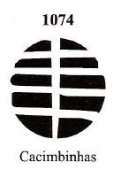
James Dingler and Klerman W. Lopes have also shown a mute cancellation of Cacimbinhas under no. 1074 in Mute Cancellations of the Brazil Empire / Carimbos Mudos do Brasil Império (Brazil Philatelic Association, Rio de Janeiro, 2000):
BPA 1074Provincia de São Pedro do Sul, 1877
Anderer Name: Pinheiro Machado (1915)
Die portugiesische Besiedlung der Region begann um 1765 durch Familien von den Azoren und der Ort gehörte zunächst zur Gemeinde Rio Grande. Einer der ersten Fazendeiros war José Dutra de Andrade. Eine lokale Legende erzählt, dass dieser aus unbekannten Gründen erblindete. In seiner Verzweiflung wusch er sich fortan nur noch mit dem Wasser der örtlichen Wasserstellen (cacimbas). Und siehe da, bald darauf konnte er wieder sehen und ließ aus Dankbarkeit eine Kapelle zu Ehren von Nossa Senhora da Luz („Unsere Liebe Frau des Lichts“) errichten.
N. Sra. da Luz de Cacimbinhas wurde im November 1851 Curato, d.h. Pfarrei, nun im Município von Piratini. Im Januar 1857 wurde der Ort zur Freguesia erhoben und erhielt im Mai 1878 die politische Autonomie als Villa in einem eigenen Município.
Am 8. September 1915 starb in einem Luxushotel in Rio de Janeiro durch einen Dolchstoß in den Rücken der einflussreiche Senator José Gomes Pinheiro Machado, der als graue Eminenz der frühen Republik nicht nur Freunde hatte:
Pinheiro Machado (1851-1915)
Sein Mörder war der in Cacimbinhas geborene politische Aktivist Francisco Manço de Paiva Coimbra. Daraufhin verfügte der designierte Intendente (Bürgermeister) von Cacimbinhas noch im selben Monat die Umbenennung der Gemeinde, die seitdem Pinheiro Machado heißt.
Wie aus dem Verzeichnis der kaiserlichen Postämter (Tabella das Agencias do Correio do Imperio, Rio de Janeiro, 1885) hervorgeht, gab es dort seit 1880 ein Postamt, doch im März des folgenden Jahres wurde in der Presse von Rio erneut die Gründung der Agentur angekündigt:
Gazeta de Noticias/RJ, 04.03.1881
R. Koester beschreibt den ersten Poststempel CRS-0060a als Doppelkreis mit den Jahreszahlen 1886 und 1887 in der Mitte. Sein Nachfolger CRS-0060b (Abb. Claudio Coelho) ist ein Kreisstempel in Negativform mit den Inschriften CACIMBINHA (sic) oben und S.P. DO SUL zwischen fünfzackigen Sternen unten. Das Datum in der Mitte fehlt, und der Stempel wurde bisher auf Ausgaben von 1890 gefunden.
Der Stempel CRS-0060c wurde bereits von Paulo Ayres in Catálogo de Carimbos Brasil-Império (S. Paulo, 1937, 1942) vorgestellt:
CRS-0060c (P.A. S. 145)
Der letzte Poststempel des 19. Jahrhunderts könnte bereits republikanisch sein, da CRS-0060d (Abb. Felipe Piccinini) Daten von 1891-1894 zeigt:
CRS-0060d (FP) 1891-1894
James Dingler und Klerman W. Lopes haben in Mute Cancellations of the Brazil Empire / Carimbos Mudos do Brasil Império (Brazil Philatelic Association, Rio de Janeiro, 2000) unter Nr. 1074 auch eine stumme Entwertung von Cacimbinhas gezeigt: