Categories
Carimbologia A-B

Brotas (BSP-0190) – Brotas (train station/Bahnhof), São Paulo (BSP-0191)

Villiers de l’Ile Adam: Carta (…) da Provincia de S. Paulo, 1847

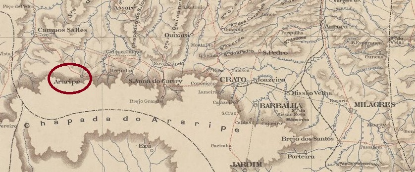
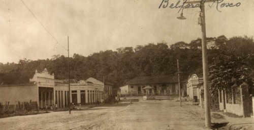
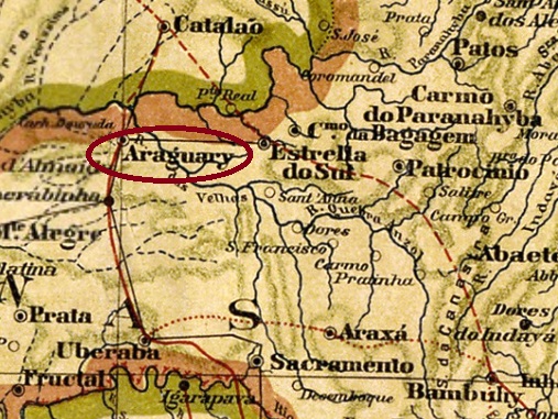
The Freguesia of Nosso Senhor das Dores de Brotas was founded in March 1846 on the north bank of the Jacaré-Pepira River in the Município of Araraquara, 240 km northwest of the provincial capital of São Paulo. In March 1853, the freguesia changed to the Município of Rio Claro, in February 1859 it was promoted to vila, and in March 1894 to town.

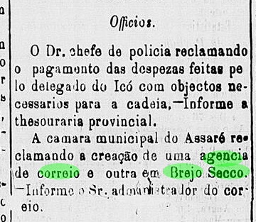
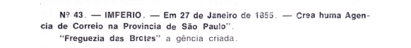
As Nova Monteiro writes in Administrações e Agencias Postaes do Brasil Imperio (Brasil Filatelico/RJ, 1934-5; Reprint SPP 1994-1999), there was a post office there since January 1855, which is confirmed by Aureo G. Santos in Agências de Correio Criadas e Suprimidas 1851, 1855, 1856 e 1857 (Brasil Filatélico 181, Rio de Janeiro, 1977):

Aureo G. Santos (op. cit.)

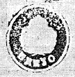
The first postmark is BSP-0190a, used until at least 1878 and known through R. Koester (Carimbologia VI).

BSP-0190a (RK) 1855-1878

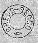
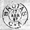
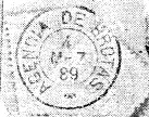
It was followed by the double circle BSP-0190b (image by Mário Celso Orsi Jr.), with the upper inscription BROTAS and inner dates from 1878 to 1881. After that there came the French type BSP-0190c, which was also seen in blue and violet with dates 1883-1889 and already shown by Koester (op. cit.):

BSP-0190c (RK) 1883-1889

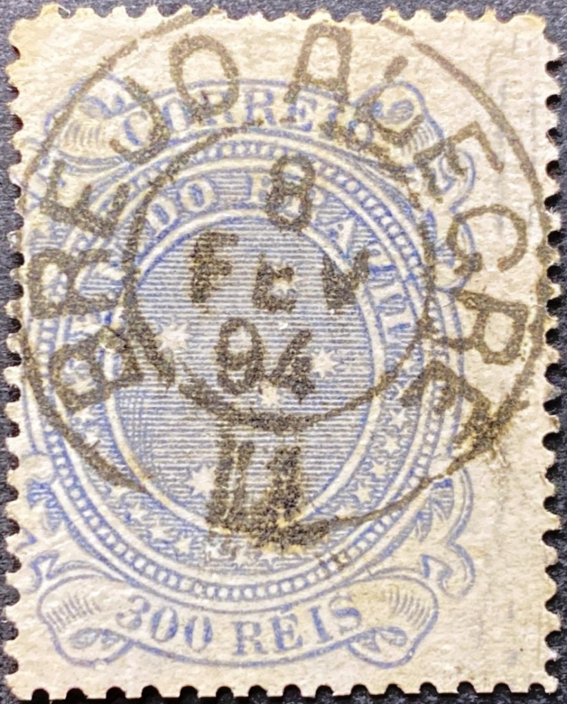
Koester also presented the successor stamp BSP-0190d showing inner dates from 1888 to at least 1890:

BSP-0190d (RK)

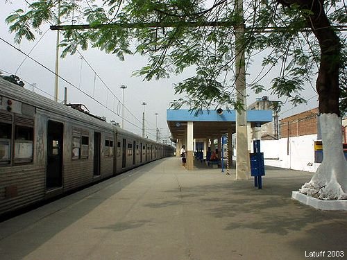
In July 1885, a train station of the E.F. Rio Claro Railway Company was opened in Brotas. Although no evidence of the existence of a post office at the station has yet surfaced, the railway line was equipped with a postwagon, as the ambulatory postmark BSP-0191a (also known through Koester) can attest:

BSP-0191a (RK) 1887-1890

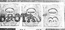
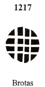
Two mute cancellations and a handwritten one from Brotas are also known. Philatelist Mário Celso Orsi Jr has reported the following mute cancellation on an 1878 item:

1878 (MO)

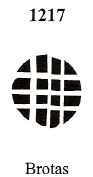
James Dingler and Klerman W. Lopes have recorded this mute cancel under no. 1217 in Mute Cancellations of the Brazil Empire / Carimbos Mudos do Brasil Império (Brazil Philatelic Association, Rio de Janeiro, 2000):

BPA 1217, 1882ff

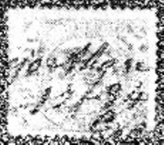
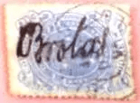
Finally, this handwritten cancellation comes from the Jorge L. Pedreira collection:

1890f (JLP)
Atlas do Imperio do Brasil, 1868

Die Freguesia von Nosso Senhor das Dores de Brotas wurde im März 1846 gegründet und lag am Nordufer des Flusses Jacaré-Pepira im Município von Araraquara, 240 km nordwestlich der Provizhauptstadt São Paulo entfernt. Im März 1853 wechselte die Freguesia zum Município von Rio Claro, im Februar 1859 erfolgte der Aufstieg zur Vila, und im März 1894 zur Stadt.

Wie Nova Monteiro in Administrações e Agencias Postaes do Brasil Imperio (Brasil Filatelico/RJ, 1934-5; Reprint SPP 1994-1999) schreibt, gab es dort ein Postamt seit Januar 1855, was durch Aureo G. Santos in Agências de Correio Criadas e Suprimidas 1851, 1855, 1856 e 1857 (Brasil Filatélico 181, Rio de Janeiro, 1977) bestätigt wird:

Aureo G. Santos (op. cit.)

Der erste Poststempel ist BSP-0190a, der bis mindestens 1878 gebraucht wurde und durch R. Koester (Carimbologia VI) bekannt ist.

BSP-0190a (RK) 1855-1878

Ihm folgte der Doppelkreis BSP-0190b (Abb. Mário Celso Orsi Jr.), mit der oberen Inschrift BROTAS und inneren Daten von 1878 bis 1881. Danach kam der französische Typus BSP-0190c (RK), der bisher auch in Blau und Violett mit Daten 1883-1889 zu sehen war und bereits durch Koester (op. cit.) gezeigt wurde:

BSP-0190c (RK) 1883-1889

Koester stellte auch den Nachfolgestempel BSP-0190d vor, der innere Daten von 1888 bis mindestens 1890 aufweist:

BSP-0190d (RK)

Im Juli 1885 wurde in Brotas der Bahnhof der E.F. Rio Claro Bahngesellschaft eingeweiht. Auch wenn bisher kein Nachweis für die Existenz eines Postamts im Bahnhof auftauchte, war die Bahnlinie mit einem Postwagon ausgestattet, wie der ambulante Poststempel BSP-0191a (auch durch Koester bekannt) belegen kann:

BSP-0191a (RK) 1887-1890

Aus Brotas kennen wir auch zwei stumme Abstempelungen und eine handschriftliche postalische Entwertung. Der Philatelist Mário Celso Orsi Jr hat folgende stumme Entwertung auf einem Objekt aus dem Jahr 1878 gemeldet:

1878 (MO)

James Dingler und Klerman W. Lopes haben in Mute Cancellations of the Brazil Empire / Carimbos Mudos do Brasil Império (Brazil Philatelic Association, Rio de Janeiro, 2000) diesen stummen Stempel unter der Nr. 1217 registriert:

BPA 1217, 1882ff

Schließlich aus der Sammlung Jorge L. Pedreira kommt diese handschriftliche Entwertung:

1890ff (JLP)
Categories
Carimbologia A-B

Brottas de Macahubas, Bahia (BBA-0170)

Atlas do Imperio do Brasil, 1868

Another name: Brotas

The freguesia of N. Sra.das Brotas was founded in March 1847 in the município of Macaúbas, located on the east bank of the river Riacho das Telhas, 610 km west of the provincial capital Salvador da Bahia. In July 1878, it was promoted to a villa as an agricultural colony, under the name Villa Agricola de N. Sra. das Brotas de Macaúbas. In June 1931 the place name was shortened to Brotas, but in December 1943 the old designation Brotas de Macaúbas returned.

The post office, ca. 1980 (IBGE)

According to R. Koester (Carimbologia VI), there had been a post office there since July 1880, which is confirmed by the provincial president’s report for the following year:

Relatorio do Conselho Interino do Governo da Bahia, 1881

The oldest postmark so far is BBA-0170a (Coll. José L. Fevereiro): a simple double circle with the inscription BROTTAS DE MACAHUBAS on top, with internal dates from about 1888 to 1897.

Villiers de l’Ile Adam: Carta (…) da Provincia da Bahia, 1848

Anderer Name: Brotas

Die Freguesia von N. Sra. das Brotas wurde im März 1847 im Município von Macaúbas gegründet und lag am Ostufer des Flusses Riacho das Telhas, 610 km westlich der Provinzhauptstadt Salvador da Bahia entfernt. Im Juli 1878 erfolgte der Aufstieg zur Villa als Landwirtschaftskolonie, unter dem Namen Vila Agricola de N. Sra. das Brotas de Macaúbas. Im Juni 1931 wurde der Ortsname zu Brotas gekürzt, aber im Dezember 1943 kehrte die alte Bezeichnung Brotas de Macaúbas zurück.

Postamt, ca. 1908 (IBGE)

Laut R. Koester (Carimbologia VI) gab es dort ein Postamt seit Juli 1880. Das wird durch den Bericht des Provinzpräsidenten fürs folgende Jahr bestätigt:

Relatorio do Conselho Interino do Governo da Bahia, 1881

Der bisher älteste Poststempel ist BBA-0170a (Samml. José L. Fevereiro): ein schlichter Doppelkreis mit der Inschrift BROTTAS DE MACAHUBAS oben, mit inneren Daten von ca. 1888 bis 1897.

Categories
Carimbologia A-B

Breves, Pará (BPA-0055)

Atlas do Imperio do Brasil, 1868

The Freguesia de N. Sra. de Sant’Anna dos Breves was founded in November 1850 on the east bank of the Breves River, 220 km west of the provincial capital Belém do Pará. The village was declared a vila in October 1851 and a town in November 1909. The place name comes from the first Portuguese landowners in the region, the brothers Manuel and Angelo Breves.

Two post office foundations have also been found here. First, in April 1850, as Nova Monteiro writes in Administrações e Agencias Postaes do Brasil Imperio (Brasil Filatelico/RJ, 1934-5; Reprint SPP 1994-1999). Then in 1856, as listed in the Directory of Imperial Post Offices (Tabella das Agencias do Correio do Imperio, Rio de Janeiro, 1885).

The oldest postmark so far is BPA-0055a, shown in R. Koester’s Carimbologia VI:

BPA-0055a (RK) 1876

It was followed by the imitation of a French type BPA-0055b, which was found with dates from about 1877 to 1889. The postmark can be seen in Catálogo de Carimbos Brasil-Império (S. Paulo, 1937, 1942) by Paulo Ayres on p. 120, but the illustration shows small deviations when compared with the picture from the Samml. Jorge L. Pedreira:

BPA-0055b (P.A. p. 120, recte JP) 1877ff-1889
Villiers de l’Ile Adam: Carta (…) das Provincias do Gram Para e Alto Amazonas, 1850

Die Freguesia de N. Sra. de Sant’Anna dos Breves wurde im November 1850 gegründet und lag am Ostufer des Flusses Breves, 220 km westlich der Provinzhauptstadt Belem do Pará entfernt. Die Ortschaft wurde im Oktober 1851 zur Vila und im November 1909 zur Stadt erklärt. Der Ortsname kommt von den ersten portugiesischen Landbesitzern der Region, die Brüder Manuel und Angelo Breves.

Auch hier wurden zwei Postamtsgründungen gefunden. Erstens im April 1850, wie Nova Monteiro in Administrações e Agencias Postaes do Brasil Imperio (Brasil Filatelico/RJ, 1934-5; Reprint SPP 1994-1999) schreibt. Dann 1856, wie im Verzeichnis der kaiserlichen Postämter (Tabella das Agencias do Correio do Imperio, Rio de Janeiro, 1885) aufgelistet.

Der bisher älteste Poststempel ist BPA-0055a, der in R. Koesters Carimbologia VI gezeigt wurde:

BPA-0055a (RK) 1876

Ihm folgte die Nachahmung eines französischen Typus BPA-0055b, der mit Daten von ca. 1877 bis 1889 zu finden war. Der Poststempel ist zwar in Catálogo de Carimbos Brasil-Império (S. Paulo, 1937, 1942) von Paulo Ayres auf S. 120 zu sehen, die Abbildung zeigt aber kleine Abweichungen, wenn man mit dem Bild aus der Samml. Jorge L. Pedreira vergleicht:

BPA-0055b (P.A. S. 120, recte JP) 1877ff-1889
Categories
Carimbologia A-B

Brejo Secco, Ceará (BCE-0060)

Atlas do Imperio do Brasil, 1868

Another name: Araripe (1889)

The parish of Sto. Antonio do Brejo Secco (St. Anthony on the Dry Marsh) was founded in November 1870 in the Município of Assaré, 520 km south of the provincial capital Fortaleza. The village rose to the status of vila in August 1875 and 14 years later it was given the name Araripe. The beautiful word of the Tupi language means place where the sun rises.

Two dates of origin for the local post office have been found. First in January 1870, as R. Koester writes in Carimbologia VI. Then in 1879, as listed in the Directory of Imperial Post Offices (Tabella das Agencias do Correio do Imperio, Rio de Janeiro, 1885). The earlier date could be a typographical error, because still at the beginning of 1874, the lack of a postal agency was lamented in the regional press:

A Constituição, 01.03.1874

The first postmark is BCE-0060a and was already shown in R. Koester’s Carimbologia VI.

BCE-0060a (RK)
Sociedade Geologica e Mineralogica, 1910

Anderer Name: Araripe (1889)

Die Pfarrei von Sto. Antonio do Brejo Secco (Hl. Antonius am Trockenen Sumpf) wurde im November 1870 gegründet und lag im Município von Assaré, 520 km südlich der Provinzhauptstadt Fortaleza entfernt. Die Ortschaft stieg im August 1875 zur Vila auf und 14 Jahre später erhielt sie den Namen Araripe. Das schöne Wort der Tupi-Sprache bedeutet Ort, wo die Sonne aufsteigt.

Zwei Entstehungszeitpunkte fürs örtliche Postamt wurden gefunden. Erstmals im Januar 1870, wie R. Koester in Carimbologia VI schreibt. Dann 1879, wie im Verzeichnis der kaiserlichen Postämter (Tabella das Agencias do Correio do Imperio, Rio de Janeiro, 1885) aufgelistet. Das frühere Datum könnte ein Druckfehler sein, denn noch am Anfang 1874 beklagte man das Fehlen einer Postagentur in der Presse:

A Constituição, 01.03.1874

Der erste Poststempel ist BCE-0060a und wurde bereits in R. Koesters Carimbologia VI gezeigt:

BCE-0060a (RK)
Categories
Carimbologia Q-R

Brejo, Rio de Janeiro (BRJ-0210)

Atlas do Imperio do Brasil, 1868

Other names: Sto. Antonio de Jacutinga, Belford Roxo (1938)

The history of this village begins around 1800, with the creation of the Fazenda do Brejo in the Freguesia of Maxambomba on the north bank of the Sarapuí River, 30 km northwest of the capital Rio de Janeiro. The settlement grew rapidly and in January 1833 became the freguesia of Sto. Antonio da Jacutinga, which belonged to the Município of Iguaçu.

Fifty years later, a station of the E.F. Rio d’Ouro railway company (Branch Line) was inaugurated there. In 1927, the railway line became the property of the E.F. Central do Brasil. In December 1938, the Freguesia do Brejo became a district called Belford Roxo, which now belonged to the Município of Nova Iguaçu, and has been an independent Município since April 1990. De name pays tribute to the engineer Raymundo Teixeira Belfort Roxo (1838-1896, spelled with a t), who was responsible for the water supply in Rio de Janeiro at the end of the century.

The railway line changed hands again in 1975 to Rede Ferroviária Federal S.A. and has belonged to the Supervias consortium since 1997.

Brejo station, ca. 1920 (Photo: Wanderley Duck, in estacoesferroviarias.com.br)
Belford Roxo station, 2003 (Photo: Carlos Latuff, in estacoesferroviarias.com.br)

As reported by the Rio press, there had been a post office on site since November 1872:

Jornal do Commercio, 22.11.1872

The first postmark is BRJ-0210a, used until at least 1877 and already known through R. Koester (Carimbologia VI):

BRJ-0210a (RK) 1872-1877ff.

Its successor BRJ-0210b was also shown to us by Koester (op. cit.). This postmark could be from a post office at the railway station, but the corresponding confirmation is still missing.

BRJ-0210b (RK) 1891-1894

The third postmark BRJ-0210c can also be seen at Koester:

BRJ-0210c (RK)
Almanak Laemmert, 1892

Andere Namen: Sto. Antonio de Jacutinga, Belford Roxo (1938)

Die Geschichte dieser Ortschaft fängt um 1800 an, mit der Entstehung der Fazenda do Brejo in der Freguesia von Maxambomba am Nordufer des Flusses Sarapuí, 30 km nordwestlich der Hauptstadt Rio de Janeiro. Die Siedlung wuchs schnell und wurde im Januar 1833 die Freguesia von Sto. Antonio da Jacutinga, die dem Município von Iguaçu zugeordnet war.

Fünfzig Jahre später wurde dort ein Bahnhof der E.F. Rio d’Ouro Bahngesellschaft (Nebenlinie) eingeweiht. 1927 ging die Bahnlinie in Besitz der E.F. Central do Brasil. Im Dezember 1938 wurde aus der Freguesia do Brejo ein Distrikt namens Belford Roxo, der nun dem Município von Nova Iguaçu gehörte und seit April 1990 ein eigenständiger Município ist. Der Name zollt Tribut an den Ingenieur Raymundo Teixeira Belfort Roxo (1838-1896, mit t geschrieben), der am Ende des Jahrhunderts für die Wasserversorgung in Rio de Janeiro zuständig war.

Die Bahnlinie wechselte abermals 1975 zur Rede Ferroviária Federal S.A. und gehört seit 1997 dem Konsortium Supervias an.

Bahnhof Brejo, ca. 1920 (Foto: Wanderley Duck, in estacoesferroviarias.com.br)
Bahnhof Belford Roxo, 2003 (Foto: Carlos Latuff, in estacoesferroviarias.com.br)

Wie die Presse aus Rio berichtete, gab es vor Ort ein Postamt seit November 1872:

Jornal do Commercio, 22.11.1872

Der erste Poststempel ist BRJ-0210a, der bis mindestens 1877 verwendet wurde und bereits durch R. Koester (Carimbologia VI) bekannt ist:

BRJ-0210a (RK) 1872-1877ff

Seinen Nachfolger BRJ-0210b zeigte uns auch Koester (op.cit.). Dieser Poststempel könnte aus einem Postamt am Bahnhof sein, allerdings fehlt die entsprechende Bestätigung.

BRJ-0210b (RK) 1891-1894

Auch der dritte Poststempel BRJ-0210c ist bei Koester zu sehen:

BRJ-0210c (RK)
Categories
Carimbologia A-B

Brejo, Maranhão (BMA-0055)

Atlas do Imperio do Brasil, 1868

The history of this village, which is old by Brazilian standards, began around 1730, when the settlement of N. Sra. da Conceição do Brejo dos Anapurus was established close to the west bank of the Parnaíba River, about 320 km southeast of the later provincial capital of São Luís do Maranhão. Around 1799, it rose to become a freguesia belonging to the Vila of Caxias. In January 1820, Brejo became a vila and in July 1870, a town.

The creation of a local post office was reported three times, the last two dates being close to each other and thus could be related. First in April 1832, as Nova Monteiro writes in Administrações e Agencias Postaes do Brasil Imperio (Brasil Filatelico/RJ, 1934-5; reprint SPP 1994-1999). Then on 2 October 1840, as can be read both in R. Koester (Carimbologia VI) and in the postal report (Relatorio Postal) in 1887. And finally on 27 October 1840, as can be seen in the postal report of 1886.

Brejo post office, ca. 1975 (IBGE)

The oldest postmark so far is BMA-0055a, which was used from about 1850 until at least 1882 and was already recorded by Paulo Ayres (Catálogo de Carimbos Brasil-Império, S. Paulo, 1937, 1942) under no. 1245:

BMA-0055a (P.A. 1245)

It was followed by BMA-0055b (fig. from the internet): a double circle with the inscription BREJO above and (2) below, plus internal dates from the period 1880-1890.

Villiers de l’Ile Adam: Carta (…) da Provincia do Maranhão, 1850

Die Geschichte dieser für brasilianische Verhältnisse alten Ortschaft fing ca. 1730 an, als die Siedlung von N. Sra. da Conceição do Brejo dos Anapurus nah am Westufer des Flusses Parnaíba entstanden ist, ca. 320 km südöstlich der späteren Provinzhauptstadt São Luís do Maranhão gelegen. Um 1799 stieg sie zu einer Freguesia auf, die der Vila von Caxias gehörte. Im Januar 1820 wurde Brejo zur Vila und im Juli 1870 zur Stadt ernannt.

Dreimal wurde die Entstehung eines örtlichen Postamts registriert, wobei die beiden letzten Termine nah aneinander liegen und dadurch zusammenhängen könnten. Erstmals im April 1832, wie Nova Monteiro in Administrações e Agencias Postaes do Brasil Imperio (Brasil Filatelico/RJ, 1934-5; Reprint SPP 1994-1999) schreibt. Danach am 2. Oktober 1840, wie man sowohl bei R. Koester (Carimbologia VI) als auch im Postbericht (Relatorio Postal) im Jahr 1887 lesen kann. Und schließlich am 27. Oktober 1840, wie aus dem Postbericht des Jahres 1886 hervorgeht.

Postamt Brejo, ca. 1975 (IBGE)

Der bisher älteste Poststempel ist BMA-0055a, der von ca.1850 bis mindestens 1882 verwendet wurde und bereits von Paulo Ayres (Catálogo de Carimbos Brasil-Império, S. Paulo, 1937, 1942) mit Nr. 1245 erfasst:

BMA-0055a (P.A. 1245) 1850ff-1882ff

Ihm folgte BMA-0055b (Abb. aus dem Internet): ein Doppelkreis mit der Inschrift BREJO oben und (2) unten, dazu innere Daten aus dem Zeitraum 1880-1890.

Categories
Carimbologia A-B

Brejo Grande, Bahia (BBA-0160)

Atlas do Imperio do Brasil, 1868

Another name: Ituaçu (1897)

The history of this village begins in the early 19th century with the foundation of the agricultural colony Vila Agrícola de N. Sra. do Alívio do Brejo Grande, located on the west bank of the river dos Ourives (today: Rio Mato Grosso), 500 km west of the provincial capital Salvador da Bahia. In April 1862, it became a freguesia belonging to the vila of Sta. Isabel do Paraguaçu, and in April 1867 it was promoted to vila. Since August 1897, the town has been called Ituaçu. The Tupi word means Great Swamp (Brejo Grande).

The Post Office, ca. 1970 (IBGE)

As Reinhold Koester writes in Carimbologia VI, there was a post office there since January 1873. This is confirmed by the report of the provincial president:

Relatorio do Presidente da Provincia/BA, 1873

The only postmark from the imperial period so far is BBA-0160a, already presented by Koester (op. cit.):

BBA-0160a (RK) 1883ff-1894ff
Carta da Republica dos Estados Unidos do Brazil, 1892

Anderer Name: Ituaçu (1897)

Die Geschichte dieser Ortschaft fängt im frühen 19. Jahrhundert mit der Gründung der Landwirtschaftskolonie Vila Agrícola de N. Sra. do Alívio do Brejo Grande an, die am Westufer des Flusses dos Ourives  (heute: Rio Mato Grosso) lag, 500 km westlich der Provinzhauptstadt Salvador da Bahia entfernt. Im April 1862 wurde daraus eine Freguesia, die der vila von Sta. Isabel do Paraguaçu gehörte, und im April 1867 erfolgte der Aufstieg zur Vila. Seit August 1897 heißt das Städtchen Ituaçu. Das Tupi-Wort bedeutet Großer Sumpf (Brejo Grande).

Das Postamt, ca. 1970 (IBGE)

Wie Reinhold Koester in Carimbologia VI schreibt, gab es dort ein Postamt seit Januar 1873. Dies wird durch den Bericht des Provinzpräsidenten bestätigt:

Relatorio do Presidente da Provincia/BA, 1873

Der bisher einzige Poststempel aus der Kaiserzeit ist BBA-0160a, der bereits durch Koester (op. cit.) vorgestellt wurde:

BBA-0160a (RK) 1883ff-1894ff
Categories
Carimbologia A-B

Brejo dos Santos, Ceará (BCE-0055)

Estado do Ceará, 1923

The freguesia named Coração de Jesus do Brejo dos Santos was founded in July 1876 and located on the west bank of the Jenipapeiro River in the Município of Porteiras, 500 km south of the provincial capital Fortaleza. This makes it easy to confuse it with the current Brejo dos Santos in the state of Paraíba, which is only 250 km away. Brejo dos Santos, from Ceará, became a vila in August 1890 and a town in December 1938, and has been called Brejo Santo ever since.

The local post office was created in April 1885, as reported in the capital’s press:

Brazil/RJ, 11.04.1885

The oldest postmark so far, BCE-0055a , was already shown in Carimbologia VI, by R. Koester, without further details:

BCE-0055a (RK)
Google Maps

Anderer Name: Brejo Santo (1938)

Die Freguesia von Coração de Jesus do Brejo dos Santos wurde im Juli 1876 gegründet und lag am Westufer des Flusses Jenipapeiro im Município von Porteiras, 500 km südlich der Provinzhauptstadt Fortaleza entfernt. Dadurch kann man sie leicht mit dem aktuellen Brejo dos Santos im Bundesstaat Paraíba verwechseln, der lediglich 250 km weit entfernt liegt. Der Brejo dos Santos aus Ceará wurde im August 1890 zu einer Vila und im Dezember 1938 zu einer Stadt, die seitdem Brejo Santo heißt.

Das örtliche Postamt wurde im April 1885 ins Leben gerufen, wie die Hauptstadtpresse berichtete:

Brazil/RJ, 11.04.1885

Der bisher älteste Poststempel BCE-0055a (RK) wurde bereits in Carimbologia VI, von R. Koester ohne weitere Einzelheiten gezeigt:

BCE-0055a (RK)
Categories
Carimbologia A-B

Brejo do Cruz, Paraíba (BPB-0065)

Villiers de l’Ile Adam: Carta (…) das Provincias do Rio Grande do Norte e Parahiba, 1848

Another name: Taquarituba

The former settlement of Taquarituba was situated on the Piranhas River, 370 km west of the later provincial capital of Paraíba do Norte (today: João Pessoa) and was provided with a chapel in honour of N. Sra. dos Milagres in 1752. The place became a freguesia of the Vila of Catolé do Rocha in October 1874 and 7 years later an independent Vila called Brejo DO Cruz. So, the place name does not refer to the Christian Cross (a Cruz), but to a certain Manuel da Cruz, who had the chapel built in 1752.

There has been an imperial post office there since August 1883, as can be read in the postal report (Relatorio dos Correios) from 1886. So far, no 19th century postmark has been seen from Brejo do Cruz.

Sociedade Geologica e Mineralogica, 1910

Anderer Name: Taquarituba

Die frühere Siedlung von Taquarituba lag am Fluss Piranhas, 370 km westlich der späteren Provinzhauptstadt Paraíba do Norte (heute: João Pessoa) und wurde 1752 mit einer Kapelle zu Ehren von N. Sra. dos Milagres versehen. Der Ort wurde im Oktober 1874 zu einer Freguesia der Vila von Catolé do Rocha und 7 Jahre später zur eigenständigen Vila mit Namen Brejo DO Cruz. Also bezieht sich der Ortsname nicht zum christlichen Kreuz (a Cruz), sondern zu einem gewissen Manuel da Cruz, der 1752 die Kapelle errichten ließ.

Ein kaiserliches Postamt gab es dort seit August 1883, wie im Postbericht (Relatorio dos Correios) aus dem Jahr 1886 zu lesen ist. Bisher wurde kein Poststempel aus dem 19. Jahrhundert aus Brejo do Cruz gesehen.

Categories
Carimbologia A-B

Brejo Alegre, Minas Gerais (BMG-0395)

Estado de Minas Geraes, 1910

Text update of June 15, 2023

See also Araguary (AMG-0105)

This village was the Freguesia of Brejo Alegre (Happy Swamp) from April 1864, belonging to the Município of Bagagem, located 650 km west of the provincial capital Ouro Preto. In October 1882 it became a vila and in August 1888 a town, named Araguary, after the great river that flows a few kilometres to the south, which was called earlier Rio das Velhas.

As Paula Sobrinho writes in História Postal de Minas Gerais (Belo Horizonte, 1997), there was a post office in Brejo Alegre since September 1883. The only 19th century postmark so far is BMG-0395a (Coll. Luis C. Fritzen). This specimen bears a date from 1894, when the town had long since been called Araguary:

BMG-0395a (LCF) 1894

R. Koester shows a handwritten cancellation under the place name Brejo Alegre in Carimbologia II:

1884 (RK)

For postmarks with Araguary see AMG-0105.

Mappa Geral do Brasil, 1911

Textaktualisierung vom 15. Juni 2023

Siehe auch Araguary (AMG-0105)

Diese Ortschaft war ab April 1864 die Freguesia von Brejo Alegre (Fröhlicher Sumpf), die dem Município von Bagagem angehörte und 650 km westlich der Provinzhauptstadt Ouro Preto entfernt lag. Im Oktober 1882 wurde daraus eine Vila und im August 1888 eine Stadt, die dem Namen Araguary trug, in Anlehnung am großen Fluss, der ein Paar km südlich fließt und früher auch Rio das Velhas hieß.

Wie Paula Sobrinho in História Postal de Minas Gerais (Belo Horizonte, 1997) schreibt, gab es in Brejo Alegre ein Postamt seit September 1883. Der bisher einzige Poststempel im 19. Jahrhundert ist BMG-0395a (Samml. Luis C. Fritzen). Dieses Exemplar trägt ein Datum aus 1894, als der Ort schon längst Araguary hieß:

BMG-0395a (LCF) 1894

R. Koester zeigt eine handschriftliche Entwertung unter dem Ortsnamen Brejo Alegre in Carimbologia II:

1884 (RK)

Für Poststempel mit Araguary siehe AMG-0105.