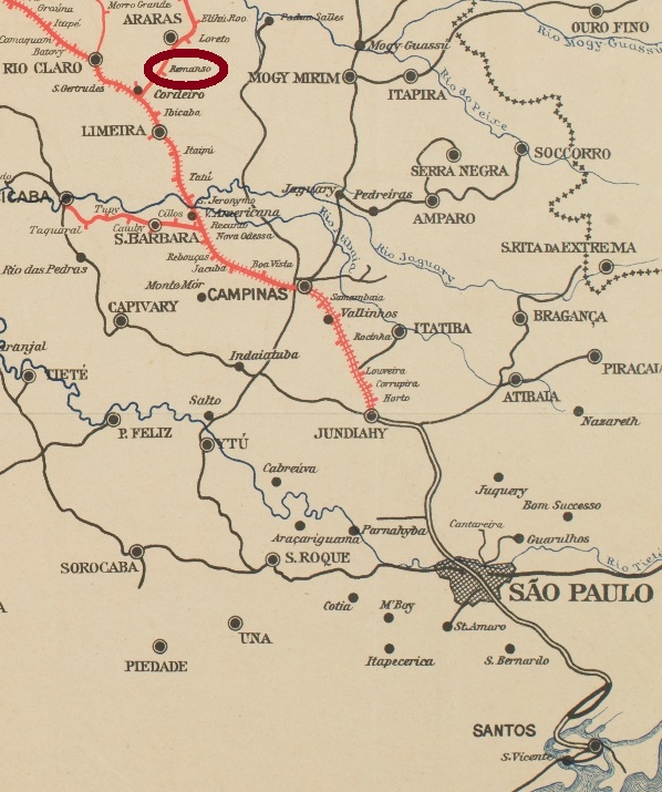
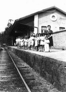
The Remanso train station was built in 1884 by the Cia. Paulista de Estradas de Ferro (Descalvado branch) near Araras, about 180 km northwest from São Paulo. We ignore when the station post office was created, but it started operations on September 6, 1888:
Correio Paulistano, September 6, 1888
From 1971 the railway went under control of the FEPASA and remained active until 1998. Now is the station building demolished, and the rails have been removed. No postal cancel from the early period could be found.
Luiz Gonzaga S. Ferreira (estacoesferroviarias.com.br)
Der Bahnhof Remanso wurde in 1884 durch die Cia. Paulista de Estradas de Ferro (Descalvado-Abzweigung) bei Araras, etwas 180 km nordwestlich von São Paulo. Wir wissen zwar noch nicht, wann das Bahnhpofspostamt entstanden ist, aber es wurde am 6. September 1888 in Betrieb genommen:
Correio Paulistano, 6.9.1888
Ab 1971 wurde die Linie von der FEPASA übernommen, die sie auch aktiv bis 1988 erhielt. Nun ist das Bahnhofsgebäude längst abgerissen, und die Gleise gibt es auch nicht mehr. Bisher konnte keine Postabstempelung der früheren Zeit gefunden werden.
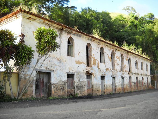
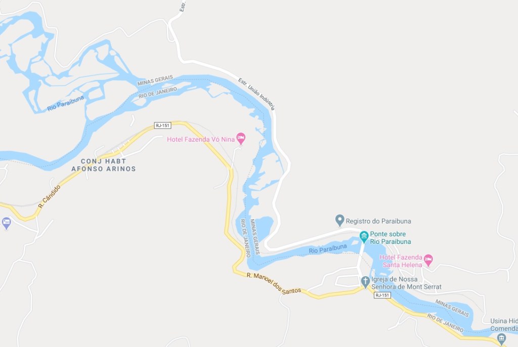
The Parahybuna (now written Paraibuna) River flows from the mountains of the Zona da Mata region in Minas Gerais towards south, where it meets the Rio Preto at the border to the state of Rio de Janeiro. Then it turns east along the same border until the confluence into the Parahyba River (now Paraíba do Sul), near Tres Rios. The Registro do Parahybuna was built in 1723 at the beginning of this borderline on the north side of the river, i.e. in Minas Gerais, but all sources state it was administrated by the Rio province. This construction – together with a bridge from the 19th century which exists still today – has made possible a new commercial road (Caminho Novo) between Minas Gerais and Rio de Janeiro.
But there is another Paraibuna River in the state of São Paulo. This one emerges near Cunha and goes west until it meets the Paraitinga River in the municipality of Paraibuna. Both rivers merge into the Paraíba do Sul River. Shortly after, near Jacareí, the bigger river turns spectacularly towards east, to cross the border to the state of Rio de Janeiro, where it meets the Paraibuna River from Minas described above.
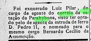
This odd situation contributed to a pretty confusion among the researchers who looked for its post offices. The Guia do Correio do Brasil of 1856 has a Parahibuna agency in Rio de Janeiro and other one in São Paulo. The Guia Postal do Imperio (1880) lists only a Parahybuna post office in São Paulo. Nova Monteiro names a Parahibuna in the Rio Province (agency created on March 26, 1840) and another one in São Paulo. Paula Sobrinho reports a Paraibuna train station of the E.F. Dom Pedro II in Minas Gerais (installed in 1874), which is confirmed by Ralph Giesbrecht. Reinhold Koester tells us about a Parahybuna post office in São Paulo (established 1844), a second one in Rio de Janeiro (which he supposed to be that one listed in 1856) and a third one at the train station in Minas Gerais. Besides, he also mentions an office called Ponte do Paraibuna, which would be identical to Registro do Paraibuna in Rio de Janeiro. Paulo Novaes (agenciaspostais.com.br) presents three post offices almost on the same spot: Registro do Paraibuna (from 1840 until ca. 1867, closed between 1846 and 1847), Paraibuna train station (which followed from 1875 till 1886), and Monte Serrat, created 1886 on the other side of the river to substitute the former. And finally, Wittig & Wittig list three Parahybunas (in MG, RJ and SP), an additional Parahibuna in RJ (identical to a former one) and Ponte do Parahybuna, also in RJ.
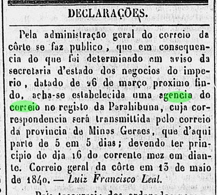
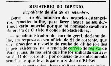
An extensive research in the local press brought us some hints to elucidate this issue. First of all, we could confirm the earliest date of the creation of a postal agency in the Registro building:
Diario do Rio de Janeiro, May 14, 1840
But two years later, the bridge was set in fire in the turmoil of the Liberal Revolution, and robbers stole money and documents from the post office:
Jornal do Commercio, October 10, 1842
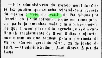
It took certainly long to rebuild the bridge, and eventually the agency had to close, for it was reopened in 1847:
Diario do Rio de Janeiro, June 26, 1847
The opening of the train station just beside the Registro in 1874 eventually caused an opening of an additional post office at the station, or the Registro agency has simply moved to the station. Although Paulo Novaes claims that this office has opened already in 1875, the earliest press notice about a station post agency was found only in 1883:
Gazeta da Tarde, November 9, 1883
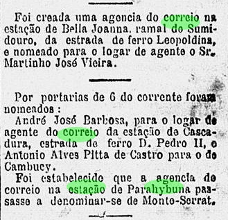
In 1886, the station post office was renamed as Monte Serrat, as stated by Novaes:
Gazeta de Noticias, November 13, 1886
However, it is still now uncertain whether the post office at the Registro has closed due to the other station office nearby, or – oddly enough – both offices kept on working side by side for a while, since the Registro office has been referred even after the train station was built:
Almanak Laemmert, 1881
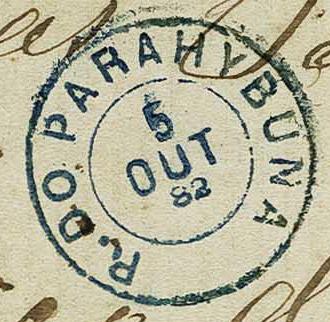
And the only known cancellation from there (RRJ-3930a, Corinphila auctions, Switzerland) also brings a mystery to unravel:
RRJ-3930a, Corinphila Zurich, Auction 237
Is the first letter a real R, or just a P which was turned to an R by hand? And the date of 1882 clearly contradicts Novaes, who indicates the closing of the Registro post office around 1867.
Google Maps
Der Parahybuna (heute Paraibuna geschrieben) ist ein Fluss, der aus dem Gebirge der Zona da Mata in Minas Gerais entspringt. Von dort fließt er in Richtung Süden, bis zur Grenze zu Rio de Janeiro, wo er den Rio Preto empfängt. Dann fließt er weiter entlang der Grenze, bis zu seiner Einmündung in den Fluss Parahyba do Sul (heute: Paraíba), nahe der Stadt Três Rios.
Der Registro do Parahybuna wurde 1723 am Anfang dieser Grenzstrecke am Nordufer, also in Minas Gerais, gebaut, aber alle Quellen behaupten, dass der Registro von Rio aus verwaltet wurde. Wie es dem auch sei, dieser Bau – zusammen mit einer im 19. Jahrhundert entstandenen Brücke, die bis heute existiert – hat einen neuen Handelsweg (Caminho Novo) zwischen Minas Gerais und Rio de Janeiro ermöglicht.
Doch gibt es einen zweiten Paraibuna-Fluss im Staat São Paulo. Dieser entspringt nah am Städtchen Cunha, fließt dann westwärts, bis er den Paraitinga-Fluss im Gebiet des heutigen Paraibuna-Município trifft. Nach dieser Mündung heißt der Fluss Paraíba do Sul, und kurz darauf, bei Jacareí, macht dieser groß gewordener Fluss eine spektakuläre Kurve nach Osten, um die Grenze zu Rio zu überqueren, wo er danach den anderen, oben beschriebenen Paraibuna-Fluss empfängt.
Diese etwas vertrackte Lage verursachte eine schöne Konfusion unter den Forschern auf deren Suche nach Postämtern. Der Guia do Correio do Brasil von 1856 hat ein Parahibuna-Postamt in Rio de Janeiro und ein anderes in São Paulo. Der Guia Postal do Imperio (1880) nennt lediglich ein Parahybuna-Postamt in São Paulo. Nova Monteiro listete einmal Parahibuna in der Rio Provinz (Postamt am 26. März 1840 entstanden) und einmal in São Paulo. Paula Sobrinho berichtet über einen Bahnhof Paraibuna der E.F. Dom Pedro II in Minas Gerais (in 1874 eingeweiht), was durch Ralph Giesbrecht bestätigt wird. Reinhold Koester erzählt uns über ein Parahybuna-Postamt in São Paulo (entstanden in 1844), ein weiteres in Rio de Janeiro (das er glaubt, identisch zu sein mit dem im GCB/1856 erwähnt) und ein drittes an einem Bahnhof in Minas Gerais. Dazu gab er eine Agentur zur Protokoll, die Ponte do Paraibuna hieß, und identisch mit Registro do Paraibuna in Rio de Janeiro sein sollte. Paulo Novaes (agenciaspostais.com.br) stellt gleich drei Postämter fast im gleichen Ort: Registro do Paraibuna (von 1840 bis ca. 1867, aber zwischen 1846 und 1847 geschlossen), Bahnhof Paraibuna (als Nachfolge-Postamt,von 1875 bis 1886), und Monte Serrat, in 1886 auf der Südseite des Flusses gegründet, um das Bahnhofspostamt zu ersetzen. Zu guter Letzt, Wittig & Wittig listen drei Parahybunas (in MG, RJ und SP), ein zusätzliches Parahibuna in RJ (das identisch mit dem Rio-Parahybuna sein soll) und Ponte do Parahybuna, auch in RJ.
Nach einer langen Recherche in der lokalen Presse kamen einige Daten zu Tage, die zur Klärung des Falls beitragen können. Zunächst können wir das früheste Datum zur Postamtentstehung im Registro-Gebäude bestätigen:
Diario do Rio de Janeiro, 14.05.1840
Schon zwei Jahre später wurde die Brücke im Aufruhr der Liberalen Revolution in Brand gesetzt, und Diebe haben Geld und Dokumente aus dem Postamt gestohlen:
Jornal do Commercio, 10.10.1842
Der Wiederaufbau der Brücke hat sicherlich lange gebraucht. Zwischendurch war das Postamt geschlossen, denn eine Wiedereröffnung fand in 1847 statt:
Diario do Rio de Janeiro, 26.06.1847
Der Bau der Eisenbahnstation gleich neben dem Registro in 1874 hat wahrscheinlich ein weiteres Postamt verursacht. Auch wenn Paulo Novaes das Eröffnungsjahr 1875 nennt, die bisher früheste Pressenotiz darüber stammt aus dem Jahr 1883:
Gazeta da Tarde, 09.11.1883
In 1886 wurde dieses Bahnpostamt in Monte Serrat umbenannt, wie Novaes angegeben hatte:
Gazeta de Noticias, 13.11.1886
Dennoch ist es bisher unklar, ob die Agentur im Registro wegen des neuen Bahnhofspostamtes geschlossen wurde (und, wenn ja, wann genau?), oder ob beide Büros für eine Übergangszeit parallel in Betrieb waren. Denn auch einige Jahre nach der Ankunft des Bahnhof wurde der Registro als Postadresse erwähnt:
Almanak Laemmert, 1881
Und auch der einzige überlieferte Registro-Stempel (RRJ-3930a, Corinphila, Zürich) bringt gleich einen Rätsel mit:
Corinphila, Zürich, Auktion 237
Ist der erste Buchstabe wirklich ein R, oder einfach ein P, der per Hand zu R umgeschreiben wurde? Und das Datum (1882) steht in direkter Widerspruch zu Novaes, der „ca.1867“ für die Schliessung des Registro-Postamts angibt.
In Imperial Brazil, a Registro was a fiscal government agency located on important commercial routes (like rivers or cattle trails), in charge of collecting taxes on transported goods, which were usually agricultural or mining products, but also slaves. Thus, intense commercial traffic would mean a higher demand for security and personal board and lodging, and so many settlements were directly caused by this fiscal activity. The most famous among them is Registro in the state São Paulo, a município since 1944.
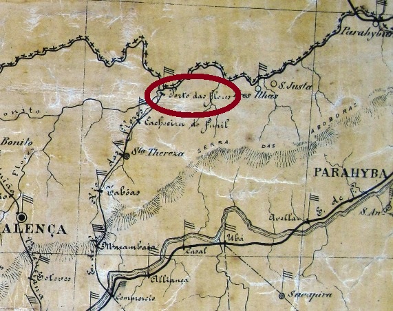
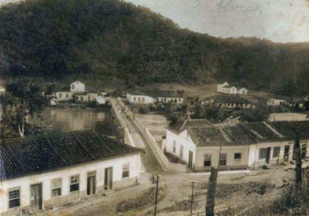
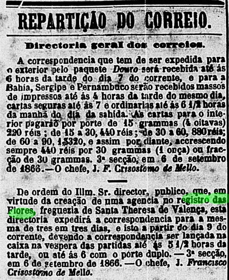
The Registro das Flores was established at the confluence of the homonymous river with the Rio Preto near Valença in the province of Rio. The place was at that time called Porto das Flores, but in 1943 chaged the name to Manuel Duarte, and is now a district of Rio das Flores.
A post office started operations in September 1866, but seems to have disappeared with the Brazilian Empire:
Correio Mercantil, September 7, 1866
No cancellation could be found by now.
Porto das Flores, Arquivo Público Mineiro (estacoesferroviarias.com.br)
Im kaiserlichen Brasilien war ein Registro eine fiskalische Behörde, die auf wichtigen Routen (Flüsse oder Trampelpfade) beauftragt war, die gesetzlichen Transportsteuer auf Waren wie landwirtschaftliche oder Bergbauprodukte – aber auch Sklaven – einzukassieren.
Auf Wegen mit regem Warenverkehr war die Nachfrage nach Aufsichtpersonal und deren Unterkunft und Verpflegung dem entsprechend höher, und dadurch sind viele Siedlungen aus dieser Tätigkeit entstanden. Die wichtigste davon wird wohl Registro sein, seit 1944 ein eigenständiger Município im Bundesstaat São Paulo.
Der Registro das Flores wurde an der Mündung des gleichnamigen Flusses mit dem Rio Preto nahe Valença in der Provinz Rio erbaut. Der Ort hieß damals noch Porto das Flores, wechselte aber den Namen zu Manuel Duarte in 1943 und ist nun ein Distrikt der Gemeinde Rio das Flores.
Ein Postamt wurde in September 1866 in Betrieb genommen, scheint aber den Wechsel zur Republik in 1889 nicht überlebt zu haben:
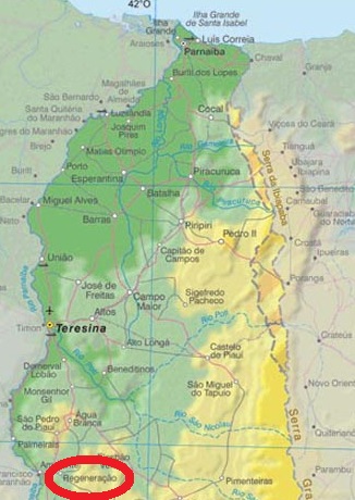
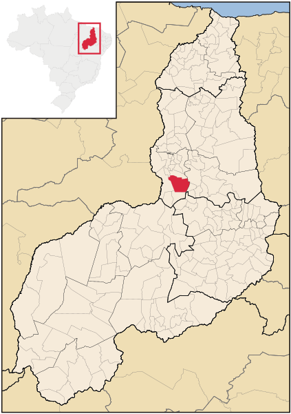
The old Villa of Regeneração has a long history close related to Amarante, and even after having acquired autonomy, it seems that it has returned several times under the Amarante administration. The confuse history tells that both localities went apart after a new settlement was initiated near the Parnaiba River in 1861, where is now the Município of Amarante, while old São Gonçalo was left away and renamed as Regeneração. They have therefore the same patron, the Portuguese São Gonçalo (1187-1262), who is venerated as a Saint in Portugal and Brazil, although his canonization process has never come to an end.
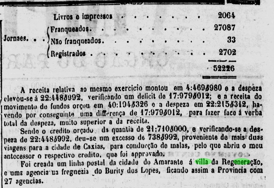
In the postal biannual report for 1883-4 by the president of the Piauhy province, a new postal line between Amarante and Regeneração was mentioned, so that we can assume a Regeneração post office was created around 1884:
A Imprensa, September 7, 1885
No imperial post cancel of Regeneração could be found by now.
Raphael Lorenzeto de Abreu (CC BY-SA)
Die alte Villa von Regeneração hat eine lange und konfuse Geschichte, die unmittelbar mit der heutigen Stadt Amarante verbunden ist. Beide Ortschaften waren früher dieselbe, gingen aber auseinander ab 1861, als ein großer Teil der Ortsbevölkerung nebst Verwaltung in die Gegend nah am Parnaíba-Fluss umsiedelte. Aus der Neusiedlung wurde Amarante, die alte verbliebene São Gonçalo wurde in Regeneração umbenannt. Dann haben beide Gemeinde den selben Schutzheiligen, den Portugiesen Gonçalo aus Amarante (1187-1262), der sowohl in Portugal als auch in Brasilien als Heiliger verehrt wird, obwohl sein Kanonisierungsprozess bis heute nicht zu Ende gekommen ist.
Im zweijährlichen Bericht für 1883-4 des Präsidenten der Provinz Piauhy wurde eine neue Postlinie zwischen Amarante und Regeneração erstmals erwähnt. Dadurch kann man annehmen, dass das Postamt in Regeneração um 1884 entstanden ist:
A Imprensa, 07.09.1885
Bisher konnte leider keine Abstempelung der Kaiserzeit aus Regeneração gefunden werden.
Monteiro e Oliveira: Mapa do Estado de São Paulo, 1927
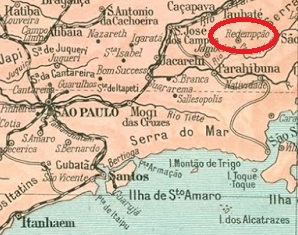
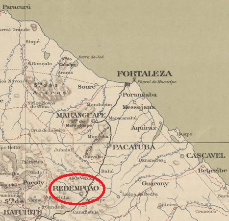
The Villa of Redempção in the province of São Paulo was created in 1877, after the emancipation from Taubaté (of which it was the District of Santa Cruz de Paiolinho), and has also got the name through the anti-slavery ideals set in motion by local politicians. So is Redenção da Serra, as the small town is called since 1944, now very proud about having liberated their slaves by February 1888, three months before the imperial abolition date. Nevertheless, it had to move in the seventies, like the neighbour town of Natividade da Serra, for their original locations were inundated by the huge barrage of the Paraibuna and Paraitinga Rivers.
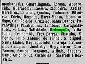
No record has been found in the Brazilian press about the Redempção post office before this note of 1879:
Jornal da Tarde, August 12, 1879
Presumably, the agency was established between 1878 and the first half of 1879. The first cancel was French-type: RSP-1060a (Coll. José A. Junges) has the typical double circle with the inscriptions REDEMPÇÃO above and the small star between parentheses below, showing the date in the interior. Used at least until 1888. It was followed by RSP-1060b (Coll. José A. Junges); quite similar to the former, it has a bigger swung dash between A and O in the local name, and the star disappears, leaving empty parentheses. Used between 1889 and 1896.
CC BY-SA
Auch die in 1877 entstandene Villa von Redempção erhielt ihr Name durch die Ideale der Bewegung gegen die Sklaverei. Nach der politischen Selbstständigkeit – vorher hieß Redempção Santa Cruz de Paiolinho und war ein Distrikt von Taubaté – haben die Lokalführer sich stark für die allmähliche Befreiung der Sklaven gemacht. Nun ist Redenção da Serra, wie der kleine Município seit 1944 heißt, recht stolz darauf, bereits in Februar 1888 – und damit drei Monate vor der offiziellen Termin im Keiserreich – keine Sklaven mehr zu haben. Dennoch musste der Ort in den siebziger Jahren umziehen, wie auch sein Nachbar Natividade da Serra, da die Originalsiedlungen vom riesigen Staudamm der Flüsse Paraibuna und Paraitinga überflutet wurden.
Keine Pressenachricht über eine Postamtgründung in Redempção wurde bisher gefunden, und die erste postalische Meldung ist aus dem Jahr 1879:
Jornal da Tarde, 12. August 1879
Vermutlich wurde das örtliche Postamt zwischen 1878 und der ersten Hälfte von 1879 errichtet. Der erste Stempel war „französischer“ Art: RSP-1060a (Samml. José A. Junges) hat den typischen Doppelkreis, mit der Inschrift REDEMPÇÃO oben und dem kleinen Stern in Klammern unten, dazu das Datum im Inneren. Verwendet frühestens bis 1888. Es folgte RSP-1060b (Samml. José A. Junges), der sehr ähnlich wie sein Vorgänger ist, hat aber eine größere Tilde zwischen A und O von REDEMPÇÃO, und der Stern ist unten verschwunden, nur die Klammer sind geblieben.
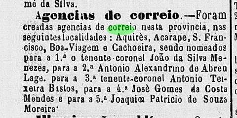
See also Acarape (Reinhold Koester: Carimbologia do Brasil Clássico I, 1961).
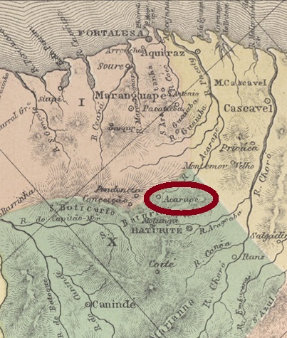
Redempção (today written Redenção, redemption) was the name given to the former town of Acarape in August 1889, to celebrate being the first locality that has abolished slavery in Brazil. This took place in this small Villa of the Ceará province in January 1st, 1883, located south of Fortaleza, near the Serra do Baturité. The rest of the country followed much later, on May 13, 1888.
The local post office must have been created in the first half of 1872:
Cearense, July 4, 1872
Redempção cancels from the Empire are certainly very rare, considering the high illiteracy rate (over 80 percent, according to Koester), and that the republic was proclaimed shortly after, on November 15, 1889. A single cancel was found, which might be republican, for it was used on a stamp of 1894: RCE-0267a (Coll. FM) has a double circle with inscriptions REDEMPÇÃO above, (CEARÁ) below, and the date inside.
Atlas do Imperio do Brazil, 1868
Siehe auch Acarape (Reinhold Koester: Carimbologia do Brasil Clássico I, 1961)
Redempção liegt südlich von der Provinzhauptstadt Fortaleza nah an der Serra do Baturité, wird heute Redenção geschrieben und bedeutet Erlösung oder Befreiung. So wurde die bisherige Villa von Acarape im August 1889 umbenannt, um das Ereignis zu feiern, dass sie die erste Ortschaft Brasiliens war, die die Sklaverei abgeschafft hat. Dies fand am 1.1.1883 statt, und damit gut fünf Jahre vor dem Rest des Landes.
Das örtliche Postamt entstand sicherlich in der ersten Hälfte des Jahres 1872:
Cearense, 04.07.1872
Redempção-Abstempelungen aus der Kaiserzeit müssen sehr selten sein, wenn wir die hohe Analphabetismusquote der Stadt (über 80 Prozent, laut Koester) berücksichtigen, sowie die Tatsache, dass Brasilien gut drei Monate nach der Umbenennung eine Republik wurde. Der einzige bisher gefundene Stempel könnte auch republikanisch sein, da er auf eine Marke von 1894 verpasst wurde: RCE-0267a (Samml. FM) hat einen Doppelkreis mit den Inschriften REDEMPÇÃO oben und (CEARÁ) unten, dazu das Datum im Inneren.
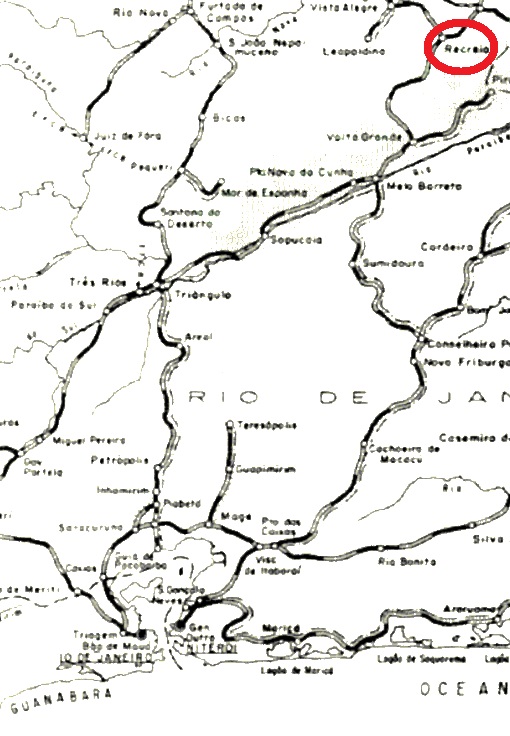
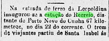
Recreio was an E.F. Leopoldina train station of the Muriahé branch, which from 1885 on should link the Manhuassu Line to São Paulo de Muriahé, in the province of Minas Gerais. From 1975 to 1996 it belonged to the Rede Ferroviária Federal. Then it went out of service, only the railroad tracks survived. The station was inaugurated in May 1876, as noticed by the press from Rio:
Gazeta de Notícias, Rio de Janeiro, May 25, 1876
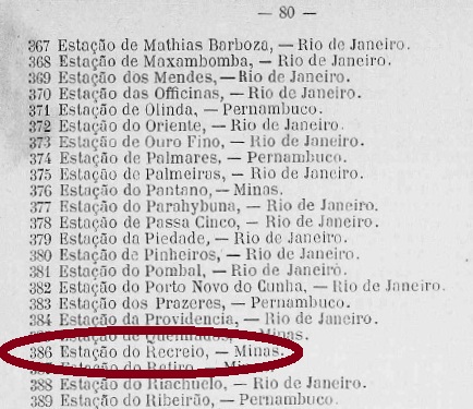
There is a controversy about when the station post office was created. Paula Sobrinho (História Postal de Minas Gerais, Belo Horizonte, 1997) states it took place on July 15, 1881, whereas the Guia Postal do Império of 1880 cites a post office at the Recreio station with agency number 386, which would lead to an earlier date:
Guia Postal do Imperio, 1880
This second hypothesis is corroborated by the presence of two early cancels and another press notice. The first cancel would be RMG-3575a (Coll. Dieter Kerkhoff), which corresponds to # 1429 by Paulo Ayres, and is found on many copies of the Dom Pedro issues from 1866 until 1878:
RMG-3575a, Paulo Ayres #1427
The second early cancel from the Recreio station, RMG-3575b (Coll. José A. Junges) has a double circle with a RECREIO inscription (above) and the date inside. On the Junges’ copy (100 Réis from the D. Pedro issue of 1877) the date was August 26, 1881, one month later than Paula Sobrinho’s given date for the office creation. Since it is quite unlikely the use of two different postal cancels at the same time in such a small office, this would be an argument for an earlier start date of this post office.
Besides, this press notice also reinforces the hypothesis of the earlier date:
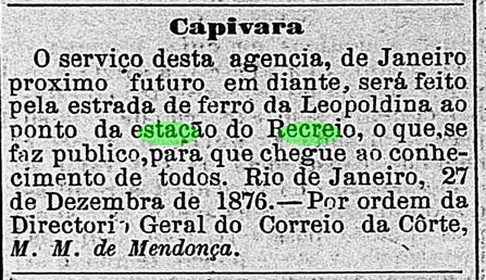
O Globo, Rio de Janeiro, January 9, 1877
“From next January on, the postal services of the Capivara agency will proceed through the Recreio station of the Leopoldina Railway. This is herewith made public. Rio de Janeiro, December 27, 1876. On behalf of the General Directory of the Imperial Mail, (signed) M. M. de Mendonça.”
Considering that the postal traffic to and from the Capivara agency (now: Palma, established December 1873) was made from January 1877 on through the Recreio station, it is quite probable that the station office was created soon afterwards.
Four other Recreio cancels follow: RMG-3575c (Coll. José A. Junges) was found in blue on D. Pedro issues of 1884 (also in bisect). It only consists of a double circle with the inscription RECREIO (above). No date provided. RMG-3575d (Coll. José A. Junges) is similar to the former, but now found in black, with dates between 1884 and 1886. On RMG-3575e (Coll. José A. Junges), the date disappears again and the inner circle is completely blackened. Found on a 1885 issue. Finally, on RMG-3575f (Coll. Marcio Protzner) the double circle is somewhat larger, the inscriptions are EST. DO RECREIO above, (MINAS) below, and the date is located inside. Found until now on early republican issues.
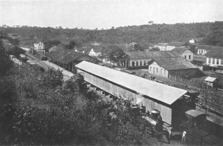
ca.1913 (estacoesferroviarias.com.br)
Recreio war ein Bahnhof der Estrada de Ferro Leopoldina in der Provinz Minas Gerais. Die so genannte Muriahé-Abzweigung hat die Manhuassu-Linie mit São Paulo de Muriahé verbunden. Von 1975 bis 1996 gehörte die Linie der Rede Ferroviária Federal. Seit 1996 ist die Strecke stillgelegt, nur die Bahnschienen sind geblieben. Wie die Presse aus Rio damals mitteilte, wurde der Bahnhof im Mai 1876 eingeweiht:
Gazeta de Noticias, Rio de Janeiro, 25.05.1876
Über das Entstehungsdatum des Bahnhofspostamtes sind die Quellen uneinig. Paula Sobrinho (História Postal de Minas Gerais, Belo Horizonte, 1997) gibt den 15.07.1881 an, während der Guia Postal do Império von 1880 ein Postamt am Bahnhof Recreio mit Nr. 386 führt, was ein Indiz für ein früheres Datum ist:
Guia Postal do Imperio, 1880
Diese zweite Datumsalternative wird unterstützt durch das Vorhandensein von zwei frühen Stempeln und einer Pressenotiz. Der erste Stempel wäre RMG-3575a (Samml. Dieter Kerkhoff); er entspricht Nr. 1429 von Paulo Ayres und wird auf vielen Marken der Dom Pedro-Ausgaben von 1866 bis 1878 überliefert:
RMG-3575a, Paulo Ayres Nr. 1429
Der zweite frühe Stempel aus dem Recreio-Bahnhof, RMG-3575b (Samml. José A. Junges) hat einen Doppelkreis mit der Inschrift RECREIO (oben) und dem Datum in Inneren. Auf dem Exemplar der Sammlung Junges – einem 100 Réis aus der D. Pedro-Ausgabe von 1877 –ist als Datum 26. August 1881 zu lesen, gut ein Monat nach dem durch Paula Sobrinho angegebenen Enstehungsdatum. Da das Vorhandensein von zwei unterschiedlichen amtlichen Poststempeln zur gleichen Zeit in einem so kleinen Amt ziemlich unwahrscheinlich ist, wäre das ein weiterer indirekter Hinweis auf ein früheres Entstehungsdatum.
Auch diese Pressenotiz mag zur Klärung des Sachverhalts beitragen:
O Globo, Rio de Janeiro, 09.01.1877
« Vom nächsten Januar an werden die Postdienste der Agentur Capivara durch den Bahnhof Recreio auf der Estrada de Ferro Leopoldina durchgeführt. Hiermit zur allgemeinen Kenntnis bekannt gegeben. Rio de Janeiro, 27. Dezember 1876. Im Auftrag der Hofpostgeneraldirektion, (gez.) M. M. de Mendonça.“
Sollte die Post von und nach dem Postamt Capivara (heute: Palma, Postagentur seit 1873) ab Januar 1877 tatsächlich durch den Bahnhof Recreio abgewickelt worden sein, wäre es folgerichtig, dass auch hier bald darauf ein Postamt entstanden ist.
Es folgen vier weitere Recreio-Stempel: RMG-3575c (Samml. José A. Junges) ist in blauer Farbe auf einigen Dom-Pedro-Ausgaben von 1884 – auch halbiert – bekannt: ein Doppelkreis und die Inschrift RECREIO (oben), sonst nichts, auch kein Datum. RMG-3575d (Samml. José A. Junges) ist ähnlich wie vor, nun aber in Schwarz und mit Jahresdaten zwischen 1884 und 1886 anzutreffen. Bei RMG-3575e (Samml. José A. Junges) verschwindet das Datum abermals, und der Innenkreis wird komplett geschwärzt. Gefunden in einer Ausgabe aus 1885. Zuletzt, auf RMG-3575f (Samml. Marcio Protzner) ist der Doppelkreis etwas größer, die Inschriften lauten EST. DO RECREIO oben, (MINAS) unten, und das Datum steht in Inneren. Bisher auf frühen Ausgaben der Republik gefunden.
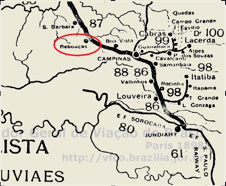
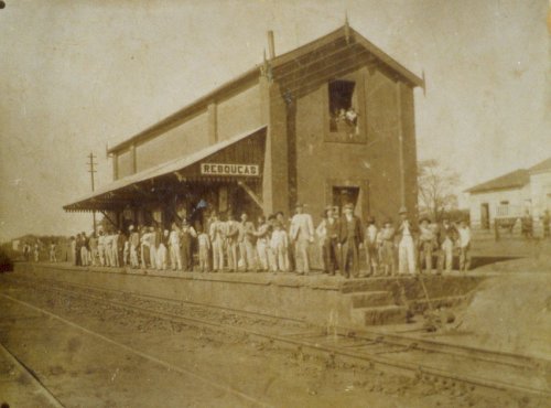
The Rebouças station of the Companhia Paulista de Estradas de Ferro was built in 1875 near Campinas. The name was a tribute to Antonio Pereira Rebouças Filho, a prominent engineer of the Cia. Paulista who died two years before.
No village existed at the beginning, except large coffee farms, and the local population has increased quite slowly. Around 1940, the locality was called Sumaré, and since 1953 it has the status of a município. The train station still exists as a culture center, but there is no traffic nowadays.
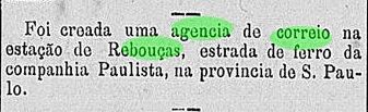
The post office at the Rebouças station was created only in December 1883, according to the press release:
Correio Paulistano, December 21, 1883
Just one cancel of the Rebouças station is known by now: RSP-1055a (image from the internet) might even be republican, for it shows the year 1895. There is a double circle with the inscriptions REBOUÇAS, above, (S. PAULO) below and the date in the inner circle.
estacoesferroviarias.com.br
Der Bahnhof Rebouças der Companhia Paulista de Estradas de Ferro wurde 1875 nahe Campinas gebaut. Der Name zollt Tribut an den Ingenieur Antonio Pereira Rebouças Filho, einen prominenten Mitarbeiter der Bahngesellschaft, der zwei Jahre zuvor verstorben war.
Bei der Gründung gab es außer riesigen Kaffeeplantagen nichts in der Umgebung, aber die Bevölkerung wuchs langsam, und um 1940 wurde die Ortschaft in Sumaré umbenannt. Seit 1953 ist Sumaré ein Município, und den Bahnhof gibt es heute noch, auch wenn kein Bahnverkehr mehr vorhanden ist. Nun beherbergt das Gebäude ein Kulturzentrum.
Eine Pressenachricht bestätigt die Entstehung des Postamts im Dezember 1883:
Correio Paulistano, 21.12.1883
Der einzige bisher überlieferte Stempel des Bahnhofs Rebouças könnte sogar bereits aus der Zeit der Republik sein: RSP-1055a (Abbildung aus dem Internet) trägt das Datum 1895. Man sieht einen Doppelkreis mit REBOUÇAS oben, (S. PAULO) unten und das Datum im Innenkreis.
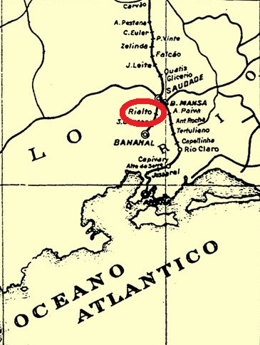
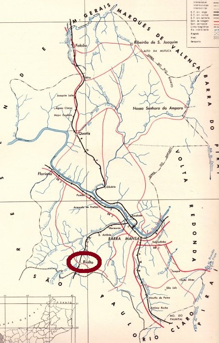
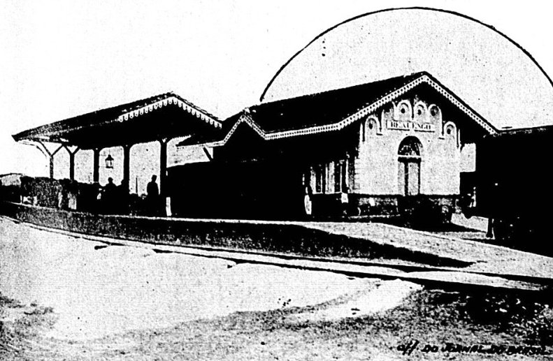
Realto (or Rialto, like the famous bridge in Venice) was a tiny station of the E. F. do Bananal railway, which linked Barra Mansa in the Rio province to Bananal in São Paulo. According to Ralph Giesbrecht (estacoesferroviarias.com.br), the railroad started in Saudade near Barra Mansa in 1882, passed through Realto in 1883 but reached Bananal only in 1888. It was some 160 km long and belonged to the E.F. do Bananal until 1918, when it was undertaken by the E.F. Central do Brasil. In 1931, it was shortly controlled by E.F Oeste de Minas, returning the very same year to the Central do Brasil until 1964, when operation ended, and the station was demolished later on.
There was a post office at the station from 1883 on, says Paulo Novaes (agenciaspostais.com.br). The only imperial cancel discovered by now is RRJ-1670a (Coll. Klerman Lopes): A double circle with the inscription EST. DO REALTO (above), a star-like ornament with four legs (below) and the date inside. Cancelled in 1885.
IBGE, 1958-1960
Realto (oder Rialto, wie die berühmte Brücke in Venedig) war ein kleiner Bahnhof der Estrada de Ferro do Bananal, einer Eisenbahnstrecke, die Barra Mansa in der Provinz Rio mit Bananal in São Paulo verbunden hat. Laut Ralph Giesbrecht (estacoesferroviarias.com.br) startete die Bahnlinie in 1882 in Saudade nahe Barra Mansa, der Bahnhof Realto kann im darauf folgenden Jahr dazu, aber die Endstrecke bis Bananal wurde erst in 1888 fertig gestellt.
Die ganze Bahnstrecke war gerade 168 km lang und blieb bei der E.F. do Bananal bis 1918, als sie von der Central do Brasil übernommen wurde. In 1931 war sie kurz im Besitz der E.F. Oeste de Minas, ging aber im gleichen Jahr zurück zur Central do Brasil. In 1964 wurde der Bahnbetrieb eingestellt, und der Bahnhof wurde kurz darauf abgerissen.
Ein Postamt gab es dort schon seit 1883, laut Paulo Novaes (agenciaspostais.com.br). Der einzige bisher bekannte Stempel der Kaiserzeit ist RRJ-1670a (Samml. Klerman Lopes): ein Doppelkreis mit der Inschrift EST. DO REALTO (oben), einem sternförmigen Ornament mit vier Zacken (unten) und dem Datum im Inneren. Ein Exemplar vom Jahr 1885 ist bekannt.
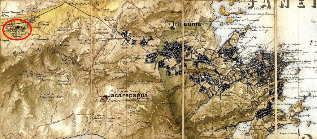
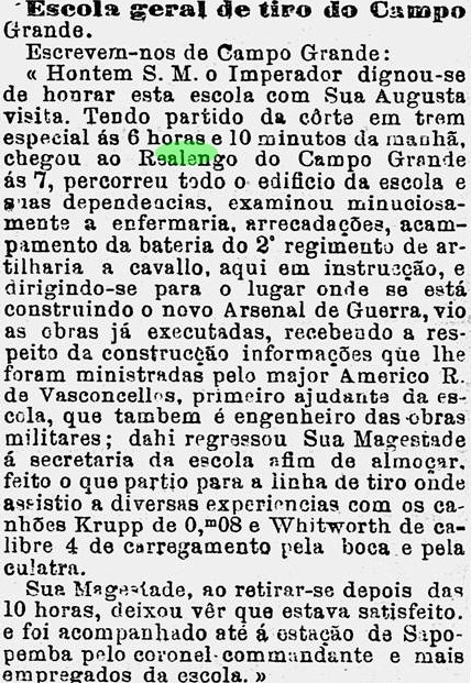
Realengo was a parish located near Campo Grande on the west side of the municipality of Rio de Janeiro. This calm suburb was given some notoriety in the second half of the 19th century through the establishment of an Imperial Artillery Academy (Escola Geral Militar de Tiro). The Emperor D. Pedro II himself visited the Academy by train in 1876, two years before the building of the local station of the E. F. Dom Pedro II:
O Globo, January 18, 1876
According to Paulo Novaes (agenciaspostais.com.br), a post office was created in Realengo around 1872. The first cancel was probably RMN-2150a (Coll. José A. Junges), which was listed by Paulo Ayres as #1426:
RMN-2150a, Paulo Ayres 1426
RMN-2150b (Coll. José A. Junges) has a double circle with the inscription REALENGO in wide spaced letters (above) and the date inside. Found between 1877 and 1888, later exemplars show eventually the year in italics.
RMN-2150c (Coll. Fuad Ferreira Filho) has a double circle with the inscription REALENGO in narrow spaced letters (above), a cross-like ornament (below) and the date inside. Found between 1891 and 1896.
Revista da Semana, November 15, 1903
Realengo war eine Pfarrei nahe Campo Grande im Westen des Landkreises Rio de Janeiro. In der zweiten Hälfte des 19. Jahrhunderts wurde dem verschlafenen Vorort durch die Einrichtung einer kaiserlichen Artillerieakademie (Escola Geral Militar de Tiro) etwas Bekanntheit verliehen. Der Kaiser selbst gestattete in 1876 eine Besichtigung der Akademie; er kam mit dem Zug, zwei Jahre bevor der dortige Bahnhof der E. F. Dom Pedro II gebaut wurde:
O Globo, 18.01.1876
Laut Paulo Novaes (agenciaspostais.com.br) wurde ein Postamt in Realengo ca. 1872 errichtet. Die erste Abstempelung war vermutlich RMN-2150a (Samml. José A. Junges), aufgelistet durch Paulo Ayres unter Nr. 1426:
RMN-2150a, Paulo Ayres 1426
RMN-2150b (Samml. José A. Junges) hat einen Doppelkreis mit Inschrift REALENGO in etwas weit gereihten Buchstaben (oben) und dem Datum innen. Angetroffen zwischen 1877 und 1888, manche spätere Exemplare zeigen kursive Jahreszahlen.
RMN-2150c (Samml. Fuad Ferreira Filho) hat einen Doppelkreis mit Inschrift REALENGO in etwas eng gereihten Buchstaben (oben), einem kreuzförmigen Ornament (unten) und dem Datum innen. Bisher gefunden zwischen 1891 und 1896.