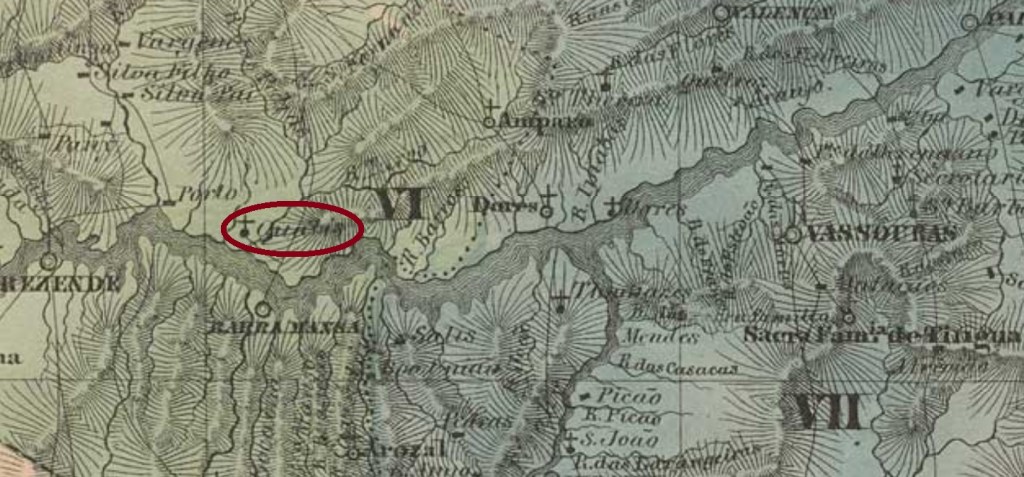
See also Nossa Senhora do Rosario dos Quatis (Koester: Carimbologia XXVIII) and Quatis (QRJ-1320)
This locality and the respective post office were already presented under Quatis (QRJ-1320). Here we should mention one imperial cancel, RRJ-2160a (Coll. José A. Junges), which features a double circle with the inscription ROSARIO DOS QUATIS above and a diamond ornament below, which is formed by four small incomplete diamonds. The dates in the centre occur between 1884 and 1887.
Villiers de l’Ile Adam: Carta (…) da Provincia de Rio de Janeiro, 1850
Siehe auch Nossa Senhora do Rosario dos Quatis (Koester: Carimbologia XXVIII) und Quatis (QRJ-1320)
Diese Ortschaft und das respektive Postamt wurden bereits unter Quatis (QRJ-1320) vorgestellt. Hier fehlt nur noch der Hinweis auf eine Abstempelung der Kaiserzeit, RRJ-2160a, (Samml. José A. Junges), die einen Doppelkreis zeigt, dazu die Inschrift ROSARIO DOS QUATIS oben und ein rautenförmiges Ornament unten, das aus vier kleinen unvollständigen Rauten besteht. Die Daten in der Mitte sind aus den Jahren 1884-1887.
Carta da Republica dos Estados Unidos do Brazil, 1892
Other names: Orobó, Itaberaba
See also Orobó (R. Koester: Carimbologia XXIX, Lohmar, 1987)
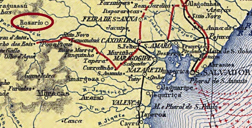
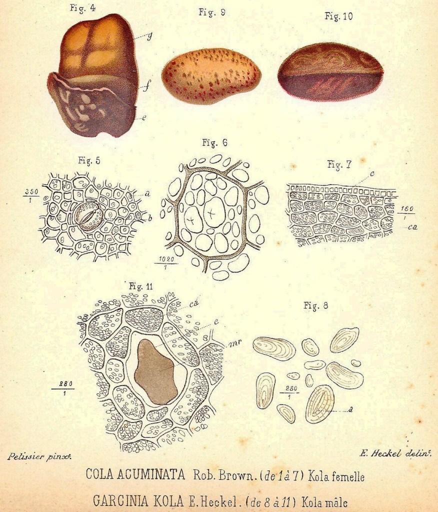
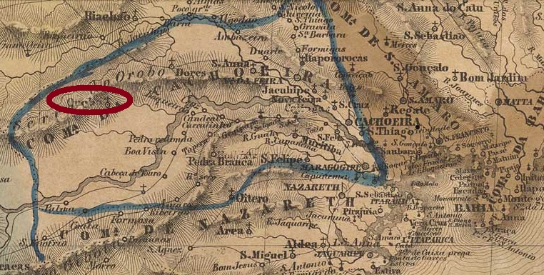
The parish of Nossa Senhora do Rosário was founded in May 1843 in the freguesia of Camisão, municipality of Cachoeira, on the east side of the Orobó mountains, around 300 km west of Salvador da Bahia. Orobó is an African medicine plant (Garcinia kola, fam. Clusiaceae), the seeds of which play an important role in the candomblé religious rituals:
Robert Valette, CC BY-SA
The locality was called both Rosário and Orobó in the press and also in maps. In March 1877 it ascended to a villa with own municipality, and in June 1897 it changed the name to the actual Itaberaba. This tupi word means brilliant stone, an allusion to the mines that attracted thousands of adventurers to this region during centuries.
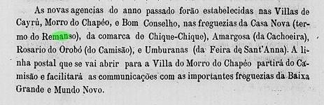
We have found not less than four different dates within ten years for the creation of this post office. The earliest one is in 1876, under Rosário do Orobó, according to the 1877 Bahia Government Council report:
Relatorio do Conselho Interino do Governo da Bahia, 1877
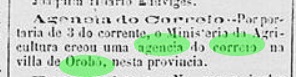
The Imperial Mail Register (Tabella das Agencias do Correio do Império) of 1885 lists the office of Orobó with creation year 1880, whereas the regional press reports an Orobó agency creation occurred on January 3, 1881:
O Monitor, January 13, 1881
This last date can be confirmed by the 1881 Bahia Government Council report:
Relatorio do Conselho Interino do Governo da Bahia, 1881
Finally, R. Koester (Carimbologia XXIX, Lohmar, 1987) states the Orobó office was created on June 25, 1886. Possibly this agency had to be closed some times between 1876 and 1886, but it is more probable that it could not start operations as often as it was created. No cancel featuring Rosário (or Rosário do Orobó) could be found from this early period. R. Koester (op. cit.) presents an Orobó cancellation.
Villers de l’Ile Adam: Mappa (…) da Provincia da Bahia, 1848
Andere Namen: Orobó, Itaberaba
Siehe auch Orobó (R. Koester: Carimbologia XXIX, Lohmar, 1987)
Die Pfarrei Nossa Senhora do Rosário wurde im Mai 1843 in der Freguesia von Camisão, Município von Cachoeira, gegründet und lag etwa 300 westlich von der Provinzhauptstadt Salvador da Bahia entfernt, an der Ostseite des Orobó-Gebirges. Orobó ist eine afrikanische Medizinpflanze (Garcinia kola, fam. Clusiaceae), deren Samen eine wichtige Rolle in Candomblé-Ritualen spielt:
Robert Valette (CC BY-SA)
Die Ortschaft wurde sowohl Rosário als auch Orobó in der Presse und auf Karten genannt. Im März 1877 stieg sie zur Villa im eigenen Município auf, und im Juni 1897 wechselte der Namen zum aktuellen Itaberaba. Dieses Wort aus der Tupi-Indianersprache bedeutet glänzender Stein, eine Andeutung auf die Edelstein-vorkommen der Region, die jahrhundertelang tausende Abenteurer angelockt haben.
Wir fanden nicht weniger als vier verschiedene Daten binnen zehn Jahren fürs örtliche Postamt. Das früheste darunter ist 1876, unter der Bezeichnung Rosário do Orobó, laut Bericht vom Regierungsrat Bahias für 1877:
Relatorio do Conselho Interino do Governo da Bahia, 1877
Das Verzeichnis der kaiserlichen Postämter (Tabella das Agencias do Correio do Império) von 1885 listet das Postamt Orobó mit Entstehungsjahr 1880 auf, während die Regionalpresse über ein neues Postamt in Orobó seit dem 3. Januar 1881 berichtet:
O Monitor, 13. Januar 1881
Dieses letzte Datum kann durch den Bericht vom Regierungsrat Bahias für 1881 bestätigt werden:
Relatorio do Conselho Interino do Governo da Bahia, 1881
Schließlich schreibt R. Koester (Carimbologia XXIX, Lohmar, 1987), das Postamt Orobó entstand am 25. Juni 1886. Möglicherweise musste diese Agentur einige Male zwischen 1876 und 1886 schließen, aber wahrscheinlicher ist es, sie konnte nicht so oft den Betrieb starten, wie sie gegründet wurde. Kein Stempel mit der Bezeichnung Rosário do Orobó konnte aus diesen Frühzeiten gefunden werden. R. Koester (op. cit.) zeigt uns immerhin eine Orobó-Abstempelung.
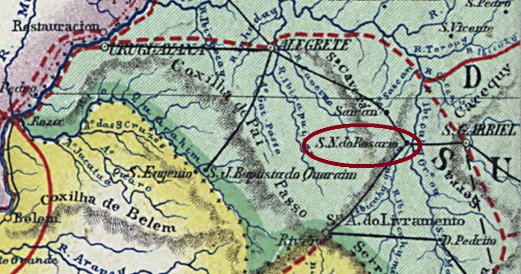
See also Passo do Rosário (R. Koester: Carimbologia XXX)
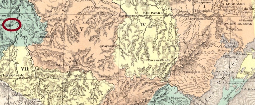
The freguesia of Nossa Senhora do Passo do Rosário was founded in December 1859 on the left bank of the Santa Maria River in the municipality of Alegrete, almost 400 km west of the province capital Porto Alegre. In April 1876 it was elevated to a villa and since the forties in the 20th century it is the municipality of Rosário do Sul.
According to Nova Monteiro (Administrações e Agencias Postaes do Brasil Imperio, in Brasil Filatelico/RJ, 1934-5; Reprint SPP 1994-1999), the post office was created in November 1867. The earliest cancel is still unknown. Unfortunately, the cancel RRS-0295a in the printed edition of the Carimbologia (Q-R) was wrongly attributed to Rosário. Further researches identified it as a cancel from Nossa Senhora do Rosário dos Quatis in Rio de Janeiro, listed in Paulo Ayres (Catálogo de Carimbos (Brasil Império), S. Paulo, 1937, 1942) under # 1368. Therefore, RRS-0295a remains vacant. The next cancel, RRS-0295b (Coll. Dieter Kerkhoff), shows a double circle with the inscription ROSARIO above and a cross-shaped ornament below, which consists of four leaflets. The existing copies have dates between 1885 and 1897.
Carta da Republica dos Estados Unidos do Brasil, 1892
Aktualisierung der Buchausgabe vom 31. Mai 2020
Andere Namen: Passo do Rosário, Rosário do Sul
Siehe auch Passo do Rosário (R. Koester: Carimbologia XXX)
Die Freguesia von Nossa Senhora do Passo do Rosário wurde im Dezember 1859 am linken Ufer des Flusses Santa Maria im Município von Alegrete gegründet, fast 400 km westlich von der Provinzhauptstadt Porto Alegre entfernt. Im April 1876 stieg sie zu einer Villa auf, und seit den 40er Jahren des 20. Jahrhunderts heißt der Município Rosário do Sul.
Laut Nova Monteiro (Administrações e Agencias Postaes do Brasil Imperio, in Brasil Filatelico/RJ, 1934-5; Reprint SPP 1994-1999) wurde das Postamt im November 1867 gegründet. Der erste Stempel bleibt noch unbekannt. Leider wurde der Stempel RRS-0295a in der Buchausgabe der Carimbologia (Q-R) fälschlicherweise Rosario/RS zugeschrieben. Spätere Forschungen ergaben, es handele sich hier um einen Stempel aus Nossa Senhora do Rosário dos Quatis in Rio de Janeiro, der von Paulo Ayres (Catálogo de Carimbos (Brasil Império), S. Paulo, 1937, 1942) unter Nr. 1368 bereits aufgelistet wurde. Dadurch muss RRS-0295a zunächst vakant bleiben. Der nächste Stempel, RRS-0295b (Samml. Dieter Kerkhoff), zeit einen Doppelkreis mit der Inschrift ROSARIO oben und einem Ornament in Kreuzform unten, das aus vier Blättchen besteht. Die vorhandenen Exemplare tragen Daten zwischen 1885 und 1897.
Carta da Republica dos Estados Unidos do Brasil, 1892
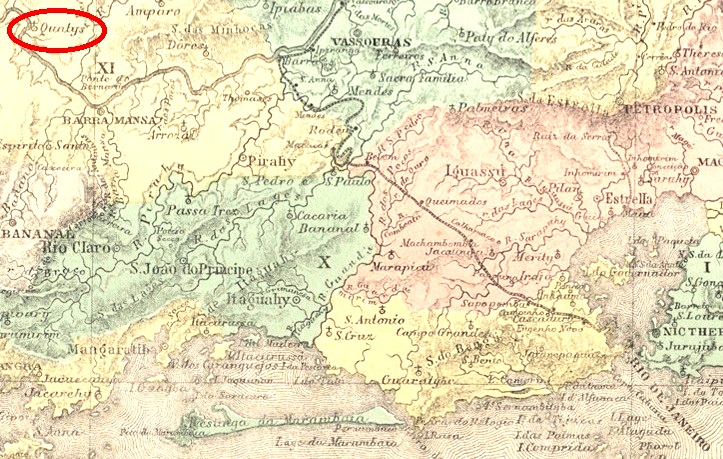
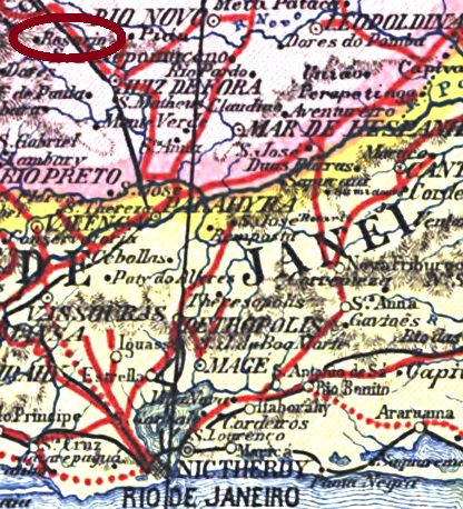
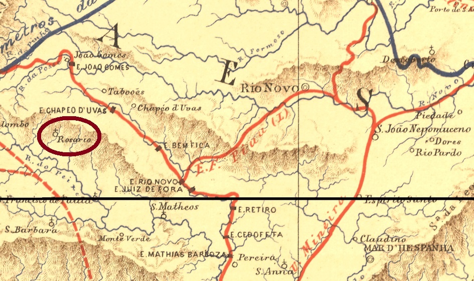
Other names: Rosário de Juiz de Fora, Augusto Franco, Rosário de Minas
The district of Rosário was founded in September 1882 in the municipality of Juiz de Fora, over 200 km south of the province capital Ouro Preto. In December 1938, it passed to the new municipality of Bias Fortes, but returned under the toponym Rosário de Minas to Juiz de Fora in December 1948. From December 1943 until then it had been called district of Augusto Franco.
According to Paula Sobrinho (História Postal de Minas Gerais, Belo Horizonte, 1997), the local post office was created in August 1881. A sole cancel from the Empire is known: RMG-2195a (Coll. José A. Junges) is found in black and green dated between 1885 and 1897, and has the inscriptions ROSARIO above and (JUIZ DE FORA) below, with the date in the centre.
Estrada de Ferro Central do Brasil, 1890
Andere Namen: Rosário de Juiz de Fora, Augusto Franco, Rosário de Minas
Der Distrikt von Rosário wurde im September 1882 im Município von Juiz de Fora gegründet und lag über 200 km südlich der Provinzhauptstadt Ouro Preto entfernt. Im Dezember 1938 ging er zum neu gegründeten Município de Bias Fortes über, kehrte aber nach Juiz de Fora in 1948 zurück, diesmal unter dem Namen Rosário de Minas. Zwischendurch, seit 1943 hieß der Distrikt Augusto Franco.
Laut Paula Sobrinho (História Postal de Minas Gerais, Belo Horizonte, 1997) entstand das lokale Postamt im August 1881. Eine einzige Abstempelung aus dem Kaiserreich ist überliefert: RMG-2195a (Samml. José A. Junges) ist in schwarz und grün mit Daten zwischen 1885 und 1897 anzutreffen, sie hat die Inschriften ROSARIO oben und (JUIZ DE FORA) unten, mit dem Datum in der Mitte.
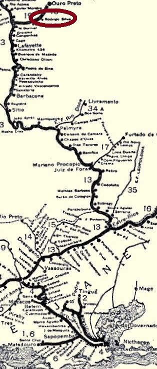
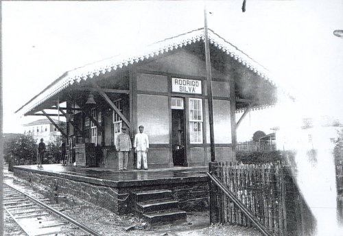
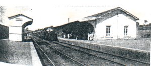
The Rodrigo Silva station was inaugurated in January 1888 in the Ouro Preto Branch of the Estrada de Ferro D. Pedro II railway, situated ca. 20 km west of the province capital. The name was a tribute to a Brazilian politician, lawyer and journalist from São Paulo (1833-1889). After the end of the Empire, the railway was renamed to Estrada de Ferro Central do Brasil. In 1964 the rail line passed to the Estrada de Ferro Leopoldina, and in 1975 to the Rede Ferroviária Federal S.A. until operation end in 1996. (estacoesferroviarias.com.br) The district of Rodrigo Silva was created around the station and exists until now, with less more than thousand inhabitants. Now the station house is an active cultural centre (see image below).
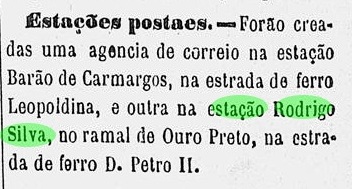
According to Paula Sobrinho (História Postal de Minas Gerais, Belo Horizonte, 1997), the station post office was created in January 1889, as the local press can ratify:
A Provincia de Minas, February 14, 1889
Only one early cancel is known: RMG-2190a (image from the internet) has a double circle with the inscriptions RODRIGO SILVA above and (MINAS) below, and the date in the centre. The sole example found was used in 1896.
ca. 1920 (Photo: Marcelo Lordeiro, apud estacoesferroviarias.com.br)
Der Bahnhof Rodrigo Silva wurde im Januar 1888 in der Ouro Preto Abzweigung der Estrada de Ferro D. Pedro II gegründet und lag ca. 20 westlich der Provinzhauptstadt Ouro Preto entfernt. Der Name zollte Tribut an einen brasilianischen Politiker, Jurist und Journalist aus São Paulo (1833-1889). Nach dem Ende des Kaiserreichs wurde die Bahngesellschaft auf Estrada de Ferro Central do Brasil umbenannt. In 1964 ging die Linie in Besitz der Estrada de Ferro Leopoldina, und in 1975 – bis zum Betriebsende in 1996 – zur Rede Ferroviária Federal S. A. (estacoesferroviarias.com.br). Um den Bahnhof herum wuchs der Distrikt Rodrigo Silva, der bis heute existiert, mit knapp über eintausend Einwohnern.
Laut Paula Sobrinho (História Postal de Minas Gerais, Belo Horizonte, 1997) wurde das Bahnhofspostamt in Januar 1889 ins Leben gerufen, wie die Lokalpresse bestätigen kann:
A Provincia de Minas, 14. Februar 1889
Ein einziger Stempel aus der Frühzeit ist bekannt: RMG-2190a (Abb. aus dem Internet) hat einen Doppelkreis mit den Inschriften RODRIGO SILVA oben und (MINAS) unten, dazu das Datum in der Mitte. Ein einziges Exemplar (mit Datum 1896) konnte gefunden werden.
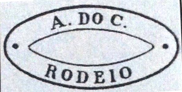
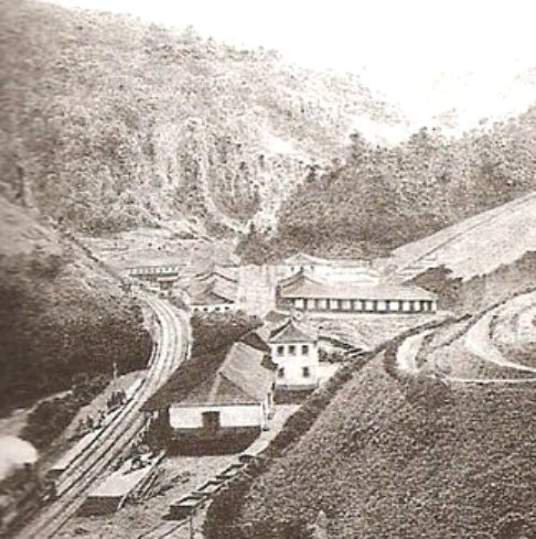
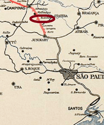
Rodeio was a train station of the Estrada de Ferro D. Pedro II Railway, Central Line, inaugurated in July 1863 in the municipality of Vassouras, and situated about 100 km northwest of Rio de Janeiro. The settlement has developed fast since then, and in October 1872 it was declared a district. In December 1943 the district was renamed Engenheiro Paulo de Frontin, as a tribute to the renowned Brazilian politician and engineer (1860-1933), and since November 1958 it has an own municipality.
The train station and the railway passed to the Estrada de Ferro Central do Brasil in 1889 and to the Rede Ferroviária Federal S.A. in 1975. In 1996 the rail line was closed, and now the station house hosts the Culture Secretary of the municipality.
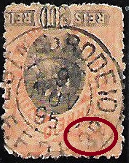
According to Nova Monteiro (Administrações e Agências Postais do Brasil Império, 1798/1869, in Brasil Filatélico 18-21, 1934-5, Reprint SPP, 1994-9), the station post office was created in August 1863. Four imperial cancels are known. RRJ-2155a is certainly the oldest one, found in objects dated until 1877, and already presented by Paulo Ayres (1937) under #1440:
RRJ-2155a, Paulo Ayres (op.cit.) #1440
RRJ-2155b (Coll. José A. Junges) has only a double circle with the inscription RODEIO above and the date in the centre. Used 1885-1886. RRJ-2155c (image from the internet) has also a double circle with the inscription EST. Do RODEIO above and (E.F.D.P.2Ọ) below, with date in the centre. One exemplar found from 1896. RRJ-2155d (image from the internet) is a variant of the former, but now with a spectacular misprint below, for it mentions (E.F.D.P.3Ọ) below, which would mean Estrada de Ferro D. Pedro the Third, an Emperor who never existed. Since we can expect that the mistake was soon corrected, this cancel must be very rare:
RRJ-2155d (EB)In 19th. century/Im 19. Jahrhundert (apud estacoesferroviarias.com.br)
Rodeio war ein Bahnhof entlang der Hauptlinie der Estrada de Ferro D. Pedro II, der im Juli 1863 im Município von Vassouras eingeweiht wurde, etwa 100 km nordwestlich von Rio de Janeiro entfernt. Die Siedlung um den Bahnhof wuchs schnell, und im Oktober 1872 wurde daraus ein Distrikt. Dieser wurde im Dezember 1843 als Engenheiro Paulo de Frontin umgetauft, um dem berühmten Politiker und Ingenieur (1860-1933) Ehre zu erweisen. Seit November 1958 ist Engenheiro Paulo de Frontin ein eigener Município.
Die Bahnlinie und auch der Bahnhof gingen in 1889 im Besitz der Estrada de Ferro Central do Brasil, und in 1975 zur Rede Ferroviária Federal S. A. Der Bahnbetrieb wurde in 1996 eingestellt, und nun dient das Bahnhofsgebäude als Kulturabteilung der Ortsverwaltung.
Laut Nova Monteiro (Administrações e Agências Postais do Brasil Império, 1798/1869, in Brasil Filatélico 18-21, 1934-5, Reprint SPP, 1994-9) entstand das Bahnhofspostamt im August 1863. Vier Abstempelungen der Kaiserzeit sind überliefert. RRJ-2155a ist sicherlich die Älteste davon, anzutreffen auf Objekten mit Datum bis 1877, wie bereits durch Paulo Ayres (1937) unter Nr. 1440 vorgestellt:
RRJ-2155a, Paulo Ayres Nr. 1440
RRJ-2155b (Samml. José A. Junges) hat nur einen Doppelkreis mit der Inschrift RODEIO oben und dem Datum in der Mitte. Benutzt 1885-1886. RRJ-2155c (Abb. aus dem Internet) hat auch einen Doppelkreis mit der Inschrift EST. DO RODEIO oben und (E.F.D.P.2Ọ) unten, mit Datum in der Mitte. Ein einziges Exemplar aus dem Jahr 1896 gefunden. RRJ-2155d (Abb. aus dem Internet) ist eine Variante vom Vorgänger, nun aber mit einem spektakulären Fehler unten, denn es heißt hier (E.F.D.P.3Ọ), was Estrada de Ferro D. Pedro der Dritte bedeuten würde, ein Kaiser, den es nie gab. Da wir davon ausgehen können, dass dieser Patzer bald behoben wurde, muss dieser Stempel sehr selten sein:
The Rocinha (= Tiny Field) train station of the Companhia Paulista de Estradas de Ferro Railway main line was built in March 1872 under the name Cachoeira (= Water Fall) in the municipality of Jundiaí, about 80 km northwest of the province capital São Paulo. The name had to change after 1875 to Rocinha, because another Cachoeira train station (today: Cachoeira Paulista) was then built in the important rail line between São Paulo and Rio.
In 1908 the locality had grown enough to become a district of Jundiaí and acquired political autonomy in 1948, when both the station and the new municipality were named Vinhedo (=Vineyard). The railway remained under the Cia. Paulista control until 1971, when it changed to the FEPASA. In 1998 the line ceased with operations, and now the station is abandoned.
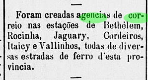
The station post office was created in December 1879, as reported in the press:
A Constituinte, December 25, 1879
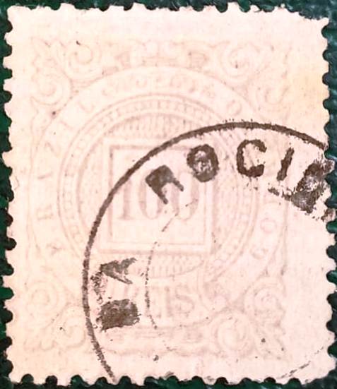
In the meantime, a copy of the oldest cancel has appeared which is said to be a “French type”. Since RSP-1135a (Coll. Fuad Ferreira Fo.) did not appear in Carimbologia (Q-R), it is presented here:
RSP-1135a (FF), 1888ff
The second cancel RSP-1135b (Coll. José A. Junges) has a double circle with the inscription ROCINHA above and a X-shaped ornament below, with the date in the centre. Copies were found dated between 1891 and 1899.
In 1918. Photo Filemon Peres (apud estacoesferroviarias.com.br)
Aktualisierung der Printausgabe (19. Oktober 2021)
Der Bahnhof Rocinha (= Feldchen) in der Hauptlinie der Companhia Paulista de Estradas de Ferro Eisenbahngesellschaft wurde unter dem Namen Cachoeira (= Wasserfall) im März 1872 gebaut und lag im Município von Jundiaí, ca. 80 km nordwestlich von São Paulo. Allerdings musste die Station nach 1875 auf Rocinha umbenannt werden, als ein weiterer Bahnhof mit Namen Cachoeira (heute: Cachoeira Paulista) in der wichtigen Linie zwischen São Paulo und Rio gebaut wurde.
Die Siedlung um den Bahnhof wuchs, der Ort wurde in 1908 ein Distrikt von Jundiaí, und in 1948 bekam er sogar die politische Autonomie als der neue Município von Vinhedo (= Weinberg). Den gleichen Namen erhielt auch der Bahnhof.
Die Bahnlinie blieb bei der Cia. Paulista bis 1971, als sie in Besitz der FEPASA ging. In 1998 wurde der Bahnverkehr eingestellt, und nun ist das Bahnhofsgebäude verlassen und marode.
Wie die Regionalpresse berichtete, wurde das Bahnhofspostamt im Dezember 1879 ins Leben gerufen:
A Constituinte, 25. Dezember 1879
Vom ältesten Stempel ist inzwischen ein Exemplar aufgetaucht, der ein „französischen Typ“ sein soll. Da RSP-1135a (Samml. Fuad Ferreira Fo.) nicht in Carimbologia (Q-R) erschienen ist, wird er hier abgebildet:
RSP-1135a (FF), 1888ff
Der zweitälteste Stempel RSP-1135b (Samml. José A. Junges) hat einen Doppelkreis mit der Inschrift ROCINHA oben und einem Ornament in Form eines X unten, dazu das Datum in der Mitte. Exemplare wurden mit Daten zwischen 1891 und 1899 gefunden.
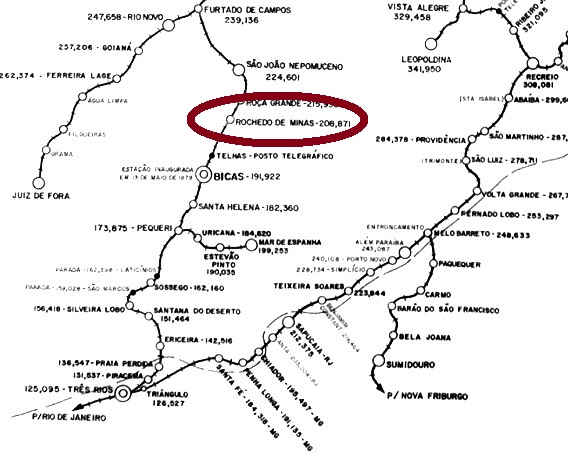
The Rochedo (= Mountain Rock) station was built in October 1882 by the Companhia União Mineira railway, Caratinga Line in the municipality of São João Nepomuceno, ca. 270 km south of the ancient province capital Ouro Preto. In 1884 the railway control passed to the Estrada de Ferro Leopoldina, and from 1975 until operation end in 1994 it belonged to the Rede Ferroviária Federal S.A. (estacoesferroviarias.com.br). The station has twice changed the name: first in 1943, to Japaraíba, then in 1948, to Rochedo de Minas. The last name was also given to the new municipality, founded in December 1962. Now the station house is a municipality building, and the tracks have been removed.
According to Paula Sobrinho (História Postal de Minas Gerais, Belo Horizonte, 1997), the station post office was created in December 1882. One imperial cancel is known: RMG-2185a (Coll. José A. Junges) has a double circle with the inscriptions ROCHEDO above and (ESTAÇÃO) below. Dates in the centre, found to date between 1885 and 1894.
ca.1980 (Photo Hugo Caramuru, apud estacoesferroviarias.com.br)
Der Bahnhof Rochedo (= Felsen) wurde im Oktober 1882 durch die Eisenbahngesellschaft Companhia União Mineira, Caratinga Linie, im Município von São João Nepomuceno gebaut und lag ca. 270 südlich der Provinzhauptstadt Ouro Preto. In 1884 ging die Linie in Besitz der Estrada de Ferro Leopoldina über, und von 1975 bis zum Betriebsende in 1994 gehörte sie zur Rede Ferroviária Federal S.A. (estacoesferroviarias.com.br). Der Bahnhof wechselte zweimal den Namen: zuerst in 1943, als er Japaraíba hieß, und dann in 1948, als er den aktuellen Namen Rochedo de Minas bekam. Die letzte Bezeichnung erhielt auch den Município bei dessen Gründung in 1962. Das Bahnhofsgebäude dient heute der Ortsverwaltung, und die Schienen wurden entfernt.
Laut Paula Sobrinho (História Postal de Minas Gerais, Belo Horizonte, 1997) entstand das Bahnhofspostamt im Dezember 1882. Eine Abstempelung aus der Kaiserzeit ist überliefert: RMG-2185a (Samml. José A. Junges) hat einen Doppelkreis mit den Inschriften ROCHEDO oben und (ESTAÇÃO) unten. Daten in der Mitte, bisher aus den Jahren 1885 bis 1894 gefunden.
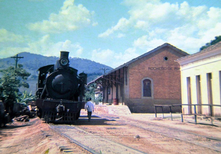
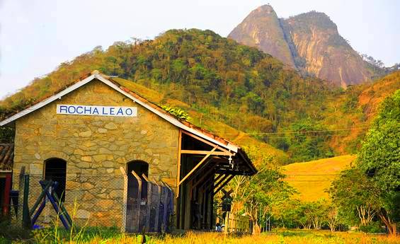
The Rocha Leão train station in the Coastal Line of the Estrada de Ferro Leopoldina was inaugurated in November 1888 near Rio das Ostras (RRJ-0845). Some sources state the original station name was União, but this could not be confirmed. The railway belonged to the E.F. Leopoldina until 1975. From then on until 1996 it was run by the Rede Ferroviária Federal S.A. Now the station house serves as a museum and cultural centre (see image below), and Rocha Leão is a district of Rio das Ostras.
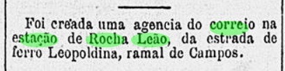
According to Paulo Novaes (agenciaspostais.com.br), the station post office was created in November 1888, which can be confirmed by the regional press:
Gazeta de Noticias, November 17, 1888
A single early cancel is known: RRJ-2154a (image from the internet) has a double circle with the inscription ROCHA LEÃO above and a cross-like ornament below. Dates found for 1897-1899.
Prefeitura de Rio das Ostras
Der Bahnhof Rocha Leão wurde im November 1888 durch die Estrada de Ferro Leopoldina in der so genannten Küstenlinie eingeweiht und lag etwas nördlich von Rio das Ostras (RRJ-0845). Einige Quellen behaupten, União war der ursprüngliche Name des Bahnhofs, aber dies konnte nicht bestätigt werden. Die Eisenbahnlinie gehörte bis 1975 der E. F. Leopoldina. Von nun an bis Betriebsende in 1996 war sie Eigentum der Rede Ferroviária Federal S. A. Heute dient das Bahnhofshaus als Museum und Kulturzentrum, und Rocha Leão ist ein Distrikt im Município von Rio Das Ostras.
Laut Paulo Novaes (agenciaspostais.com.br) wurde das Postamt im November 1888 in die Wege geleitet, was auch in der Presse zu lesen ist:
Gazeta de Noticias, 17. November 1888
Ein einziger Stempel der Frühzeit ist überliefert: RRJ-2154a (Abb. aus dem Internet) hat einen Doppelkreis mit der Inschrift ROCHA LEÃO oben und ein kreuzförmiges Ornament unten. Nutzungsdaten zwischen 1897 und 1899.
Villiers de l’Ile Adam: Carta (…) da Provincia de Minas Geraes, 1849
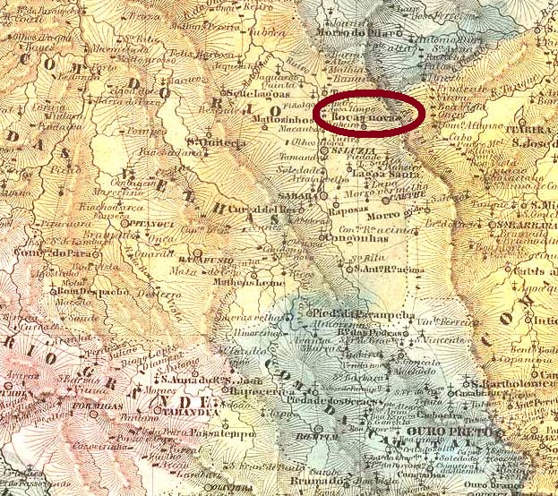
The district of Nossa Senhora da Madre de Deus de Roças Novas (= Our Lady Mother of God of New Fields) was founded in April 1841 in the municipality of Caeté, over 120 km north of the early province capital Ouro Preto. Surprinsingly, it has remained in this status and under the same name until today, contrary to almost all other researched localities.
According to Paula Sobrinho (História Postal de Minas Gerais, Belo Horizonte, 1997), the local post office was created in August 1882, which is confirmed by the Imperial Mail Register (Tabella das Agencias do Correio do Império) of 1885. One imperial cancel is known: RMG-2180a (Coll. José A. Junges) has a double circle with the inscription ROÇAS NOVAS above and an ornament in diamond form below, which is formed by four small diamonds. The found exemplars have dates between 1888 and 1895.
Atlas do Imperio do Brasil, 1868
Der Distrikt von Nossa Senhora da Madre de Deus de Roças Novas (= Unsere Liebe Frau Mutter Gottes von den Neuen Feldern) wurde im April 1841 im Município von Caeté gegründet und liegt über 120 km nördlich der ehemaligen Provinzhauptstadt Ouro Preto. Erstaunlicherweise behielt die Ortschaft den Namen und Verwaltungsstatus bis heute, im Gegensatz zu fast allen anderen Orten, die hier besprochen werden.
Laut Paula Sobrinho (História Postal de Minas Gerais, Belo Horizonte, 1997) entstand das örtliche Postamt im August 1882, was durch das Verzeichnis der kaiserlichen Postämter (Tabella das Agencias do Correio do Império) von 1885 bestätigt wird. Ein Stempel aus der Kaiserzeit ist bekannt: RMG-2180a (Samml. José A. Junges) hat einen Doppelkreis mit der Inschrift ROÇAS NOVAS oben und ein rautenförmiges Ornament unten, das aus vier kleinen Rauten besteht. Die gefundenen Exemplare wurden zwischen 1888 und 1895 benutzt.