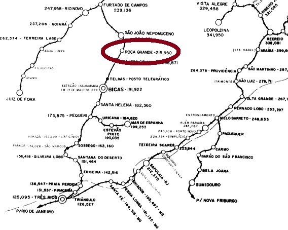
Roça Grande (=Large Field) was the name of two train stations in Minas Gerais, the older of which was installed in June 1880 south of São João Nepomuceno in the Caratinga Line of the Estrada de Ferro Cia. União Mineira railway. According to Ralph Giesbrecht (estacoesferroviarias.com.br), the railway control passed to the Estrada de Ferro Leopoldina from 1884 until 1975, and afterwards to the Rede Ferroviária Federal S.A. until operation end in 1994. Now the station house is demolished, and the tracks have been removed, while Roça Grande has become a district of the municipality of S. João Nepomuceno.
Paula Sobrinho (História Postal de Minas Gerais, Belo Horizonte, 1997) writes that the station post office was created in July 1881. Two imperial cancels are known. RMG-2175a (Coll. José A. Junges) has a double circle with the inscription ROÇA GRANDE above and the date in the centre, the sole exemplar found to date is of 1885. RMG-2175b (Coll. José A. Junges) is similar to the former, but now the inscription is ROÇA GRANDE (ESTAÇÃO). Used between 1885 and 1894.
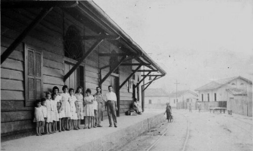
In ca. 1960. (Photo: M. Palhares, apud estacoesferroviarias.com.br)
Roça Grande (=Weites Feld) hießen zwei Bahnhöfe in Minas Gerais; der Ältere von beiden wurde im Juni 1880 in Betrieb genommen. Er lag südlich von São João Nepomuceno in der Caratinga Linie der Estrada de Ferro Cia. União Mineira. Laut Ralph Giesbrecht (estacoesferroviarias.com.br) ging die Linie von 1884 bis 1975 in Besitz der Estrada de Ferro Leopoldina über, und danach – bis Betriebsschluss in 1994 – zur Rede Ferroviária Federal S.A. Heute ist das Bahnhaus abgerissen, und die Schienen wurden entfernt. Roça Grande heißt nun ein Distrikt von S. João Nepomuceno.
Paula Sobrinho (História Postal de Minas Gerais, Belo Horizonte, 1997) schreibt, dass das Bahnhofspostamt im Juli 1881 gegründet wurde. Zwei Stempel aus der Kaiserzeit sind überliefert. RMG-2175a (Samml. José A. Junges) hat einen Doppelkreis mit der Inschrift ROÇA GRANDE oben und dem Datum in der Mitte, das einzige bisher gefundene Exemplar ist 1885 datiert. RMG-2175b (Samml. José A. Junges) ist ähnlich wie sein Vorgänger, nun aber lautet die Inschrift ROÇA GRANDE (ESTAÇÃO). Gebraucht zwischen 1885 und 1894.
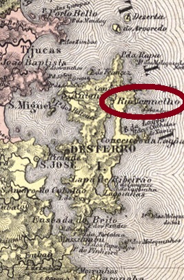
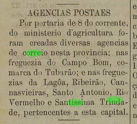
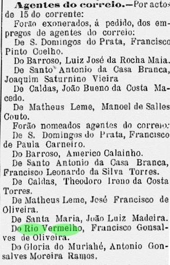
The second Red River with a post office in imperial Brazil was the Rio Vermelho of the Santa Catarina island, a district (established August 1831) of the province capital Desterro. In December 1943 the toponym was changed to Praia dos Inglezes, but five years later the old name was aggregated to the new one. Since then, the district is called Ingleses do Rio Vermelho.
The post office was created in March 1884, as the local press reports:
Jornal do Commercio, March 14, 1884
No imperial cancel has been found to date.
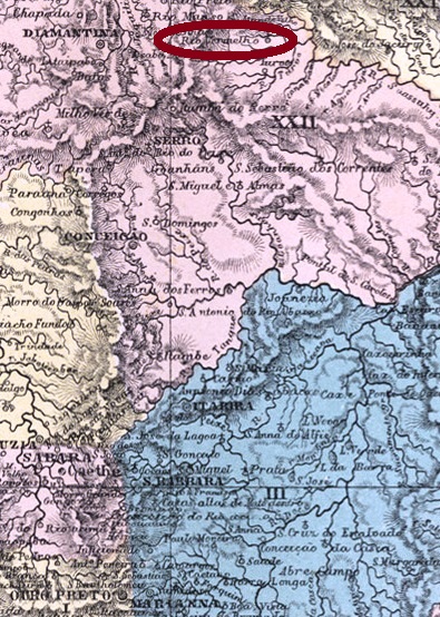
Villiers de l’Ile Adam: Carta (…) da Provincia de Santa Catharina, 1848
Der zweite Rote Fluss mit einem Postamt im Kaiserreich Brasilien war Rio Vermelho auf der Insel Santa Catarina, ein im August 1831 gegründeter Distrikt der Provinzhauptstadt Desterro. Im Dezember 1843 wurde der Ortsname zu Praia dos Inglezes gewechselt, aber schon fünf Jahre später kehrte der alte Name zurück, nun zum Neuen zusammen gefügt, und seitdem heißt der Distrikt Ingleses do Rio Vermelho.
Das Postamt wurde im März 1884 ins Leben gerufen, wie die Lokalpresse bereichtet:
Jornal do Commercio, 14 März 1884
Kein Stempel aus der Kaiserzeit wurde bisher gefunden.
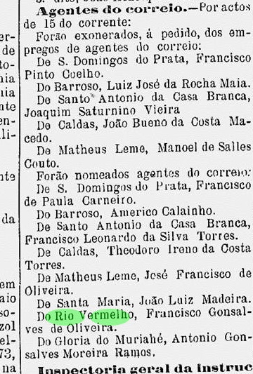
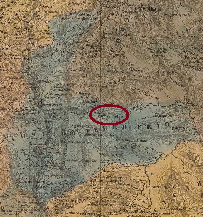
After three Rio Verde (=Green River) there are two Rio Vermelho (=Red River). The first one was the district of Nossa Senhora da Penha do Rio Vermelho, founded in 1817 in the municipality of Sabará, over 300 km north of the ancient province capital Ouro Preto in Minas Gerais. In March 1838 it passed to the municipality of Serro, and in December 1938 it was given an own municipality with the town status.
According to Paula Sobrinho (História Postal de Minas Gerais, Belo Horizonte, 1997), the post office was created in May 1881, and the first postal agent was soon presented in the regional press:
A Actualidade, June 18, 1881
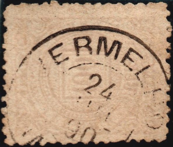
Two cancels are known: RMG-2170a (Coll. José A. Junges) has a double circle with the inscription RIO VERMELHO above and a diamond ornament below, which consists of four small leaflets. Dates found for 1885-1896. RMG-2170b (Coll. José A. Junges) may be already republican, for one sole copy was found, dated 1890. It has a double circle with the inscriptions R. (or RIO, the image is unfortunately unclear) VERMELHO above and (MINAS) below, with date in the centre.
Please note: In the Carimbologia (Q-R) print edition, the originally depicted RMG-2170b cancel was actually a worn version of RMG-2170a. Therefore here the new version:
RMG-2170b, corrected version (Coll. José A. Junges)Villiers de l’Ile Adam, Carta (…) da Provincia de Minas Geraes
Buchausgabe-Aktualisierung vom 7. Juni 2020
Nach dreimal Rio Verde (=Grüner Fluss) folgt zweimal Rio Vermelho (=Roter Fluss). Der erste davon war der Distrikt von Nossa Senhora da Penha do Rio Vermelho, in 1817 im Município von Sabará, über 300 km nördlich der Provinzhauptstadt Ouro Preto in Minas Gerais gegründet. Im März 1838 wechselte der Distrikt zum Município von Serro, und im Dezember 1938 stieg er zur Stadt in eigenem Município.
Laut Paula Sobrinho (História Postal de Minas Gerais, Belo Horizonte, 1997) entstand das Postamt im Mai 1881, und im darauf folgenden Monat wurde der erste Postangestellte durch die Regionalpresse vorgestellt:
A Actualidade, 18. Juni 1881
Zwei Stempel dieser Ortschaft sind überliefert: RMG-2170a (Samml. José A. Junges) hat einen Doppelkreis mit der Inschrift RIO VERMELHO oben und ein rautenförmiges Ornament unten, das aus vier Blättchen besteht. Daten gefunden zwischen 1885 und 1896. RMG-2170b (Samml. José A. Junges) könnte bereits republikanisch sein, da das einzig bekannte Exemplar in 1890 verwendet wurde. Er hat einen Doppelkreis mit den Inschriften R. (oder RIO, leider ist die Abbildung unvollständig) VERMELHO oben und (MINAS) unten, dazu das Datum in der Mitte.
Bitte beachten: Der in der Druckausgabe der Carimbologia (Q-R) ursprünglich abgebildete Stempel RMG-2170b hat sich später als verbrauchte Variante von RMG-2170a erwiesen. Darum zeigen wir hier die richtige Version:
RMG-2170b, korrigierte Fassung (Samml. José A. Junges)
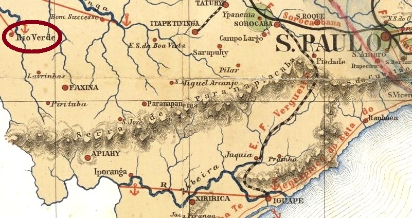
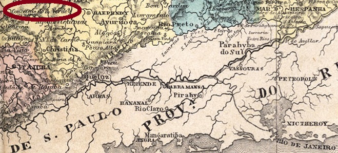
The freguesia of São João Baptista do Rio Verde was founded in March 1855 in the municipality of Faxina, over 350 km west of the province capital São Paulo. In March 1871 it was elevated to a Villa, and in June 1898, to a town. One year later the toponymic was changed to the actual Itaporanga, which in the tupi-guarani language means Beautiful Stone.
According to the Imperial Mail Register (Tabella das Agencias do Correio do Império) of 1885, the local post office was created in 1874. Two cancels are known: RSP-1130a (Coll. José A. Junges) has a double circle with the inscriptions * RIO VERDE * above and (…)OS below, on the sole found copy (dated June 1887) the beginning of the lower inscription is missing. RSP-1130b (Coll. José A. Junges) may be already republican, for the sole known copy is dated 1897: also a double circle, now with RIO VERDE above and an asterisk below.
C.D. Rath: Carta da Província de São Paulo, 1886
Die Freguesia von São João Baptista do Rio Verde wurde im März 1855 im Município von Faxina über 350 km westlich von der Provinzhauptstadt São Paulo gegründet. Im März 1871 stieg sie zur Villa und im Juni 1898 zur Stadt auf. Ein Jahr später wurde der Name zur aktuellen Bezeichnung Itaporanga geändert, was in der Tupi-guarani-Sprache Schöner Stein bedeutet.
Laut dem Verzeichnis der kaiserlichen Postämter (Tabella das Agencias do Correio do Império) von 1885 entstand das örtliche Postamt in 1874. Zwei Stempel sind bekannt: RSP-1130a (Samml. José A. Junges) hat einen Doppelkreis mit der Inschrift * RIO VERDE * oben und (…)OS unten, wobei im einzigen vorhandenen Exemplar (datiert Juni 1887) der Anfang der unteren Inschrift fehlt. RSP-1130b (Samml. José A. Junges) könnte bereits republikanisch sein, denn das einzige Exemplar wurde in 1897 verwendet: hier haben wir wieder einen Doppelkreis, nun mit RIO VERDE oben und einem Asterisk unten.
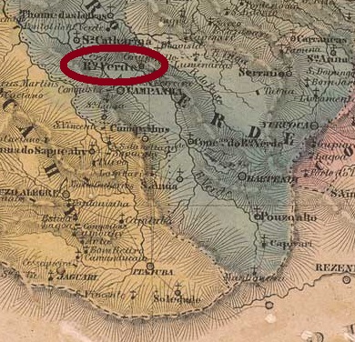
See also Conceição do Rio Verde (R. Koester: Carimbologia XIII)
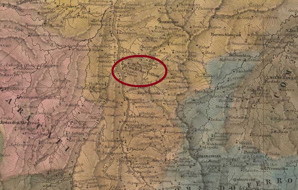
The District of Nossa Senhora da Conceição do Rio Verde was created in March 1839 in the municipality of Baependy, over 400 km southwest of the ancient provincial capital Ouro Preto. In September 1901 it changed to the municipality of Aguas Virtuosas, and 10 years later it acquired the political autonomy with an own municipality.
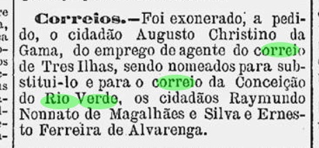
According to R. Koester (Carimbologia XIII) and Paula Sobrinho (História Postal de Minas Gerais, Belo Horizonte, 1997), the post office was created in November 1878. The first officer was announced in the regional press one month later:
A Actualidade, December 12, 1878
R. Koester (op. cit.) has already presented two local cancels featuring CONCEIÇÃO DO RIO VERDE, both of 1886 ff. No cancel has to date appeared showing only RIO VERDE.
Villiers de l’Ile Adam: Carta … da Provincia de Minas Geraes, 1849
Siehe auch Conceição do Rio Verde (R. Koester: Carimbologia XIII)
Der Distrikt von Nossa Senhora da Conceição do Rio Verde wurde im März 1839 im Município von Baependy gegründet, über 400 km südwestlich der ehemaligen Provinzhauptstadt Ouro Preto entfernt. Im September 1901 wechselte er zum Município von Aguas Virtuosas, und 10 Jahre später erhielt er die Verwaltungsautonomie als eigenständiger Município.
Laut R. Koester (Carimbologia XIII) und Paula Sobrinho (História Postal de Minas Gerais, Belo Horizonte, 1997) entstand das Postamt im November 1878. Der erste Postangestellte wurde in der Regionalpresse im folgenden Monat angekündigt:
A Actualidade, 10. Dezember 1878
R. Koester (op.cit.) hat bereits zwei Ortsstempel mit CONCEIÇÃO DO RIO VERDE vorgestellt, beide ab 1886. Kein Stempel konnte bisher nur mit RIO VERDE gefunden werden.
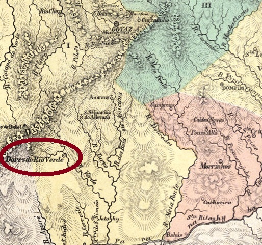
See also R. Koester: Dores do Rio Verde (Carimbologia XVI)
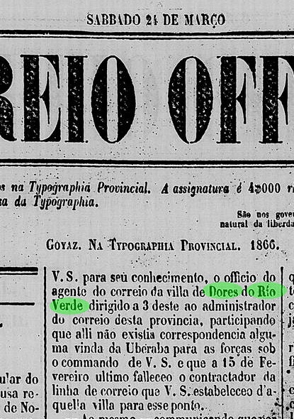
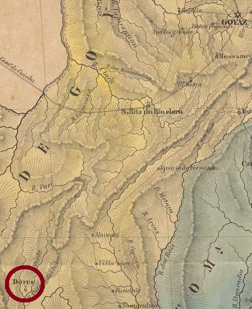
The district of Dores do Rio Verde was founded in August 1848, over 300 km south of the former province capital Goyaz (today Goiás Velho), to which it belonged. In November 1854, Rio Verde was elevated to a Villa, and in July 1882 it was given the town status.
R. Koester (Carimbologia XVI) asserts the post office was created in 1870, which is confirmed by the Imperial Mail Register (Tabella das Agencias do Correio do Império) of 1885. Nevertheless, there is a notice of March 1866 in the official provincial press referring directly to the post office clerk of this locality:
Correio Official de Goyaz, March 24, 1866
Thus, the post office must have been opened for a first time between 1860 (for it wasn’t listed in 1859) and 1866 and closed before 1870, the year it was reopened. A single imperial cancel is known: RGO-0175a (Coll. José A. Junges) has a double circle with the inscription RIO-VERDE above and a diamond ornament below, with the date in the centre. A sole copy was found, dated 1887.
Villers de l’Ile Adam, Carta… da Provincia de Goyaz, 1849
Siehe auch R. Koester: Dores do Rio Verde (Carimbologia XVI)
Der Distrikt von Dores do Rio Verde wurde im August 1848 im Verwaltungsbezirk der Provinzhauptstadt Goyaz (heute Goiás Velho) gegründet, wovon er über 300 km südlich lag. Im November 1854 stieg Rio Verde zur Villa auf, und im Juli 1882 erhielt die Ortschaft den Stadtstatus.
R. Koester (Carimbologia XVI) gibt 1870 als das Gründungsjahr fürs Postamt an, was das Verzeichnis der kaiserlichen Postämter (Tabella das Agencias do Correio do Império) von 1885 bestätigte. Gleichwohl liegt eine Nachricht des Amtsblatts für Goyaz aus März 1866 vor, in der der Postangestellte in Rio Verde erwähnt wird:
Correio Official de Goyaz, 24. März 1866
Daraus folgt, dass dieses Postamt irgendwann zwischen 1860 (da es in 1859 nicht aufgelistet war) und 1866 erstmals eröffnet wurde, um vor 1870 wieder geschlossen zu werden. Ein einziger Stempel aus der Kaiserzeit ist überliefert: RGO-0175a (Samml. José A. Junges) hat einen Doppelkreis mit der Inschrift RIO-VERDE oben und einem rautenförmigen Ornament unten, dazu das Datum in der Mitte. Ein Exemplar ist bekannt, mit Datum 1887.
Villiers de l’Ile Adam: Mappa (…) da Provincia de Minas Geraes, 1849
Print edition update of May 17, 2020
Other names: Barra do Rio das Velhas, Guacuhy
See also Guaicuhy (R. Koester: Carimbologia XXI)
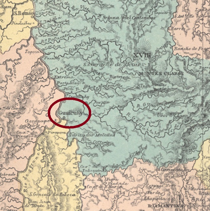
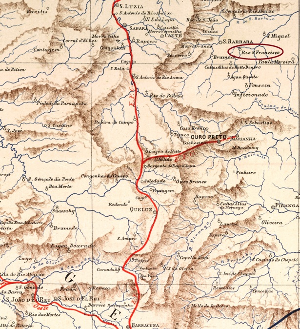
There were two Rio das Velhas (= Old Ladies’ River) in the imperial province of Minas Gerais. The first one, now called Araguari, has its source in the south-western Serra da Canastra and flows westwards until it reaches the Paranaiba. The second Rio das Velhas is historically by far more important, for it flows through regions that formed politics and wealth of the whole region. It springs up from the hills near the former capital Ouro Preto and runs 800 km towards northwest into the São Francisco River.
Around the river mouth there was the former freguesia of Nossa Senhora do Bom Sucesso e Almas da Barra do Rio das Velhas, founded in 1839 in the municipality of Curvello. The freguesia, which ascended to a Villa in November 1861 changing the toponym to Guaicuhy, is nowadays a district of the municipality of Várzea da Palma.
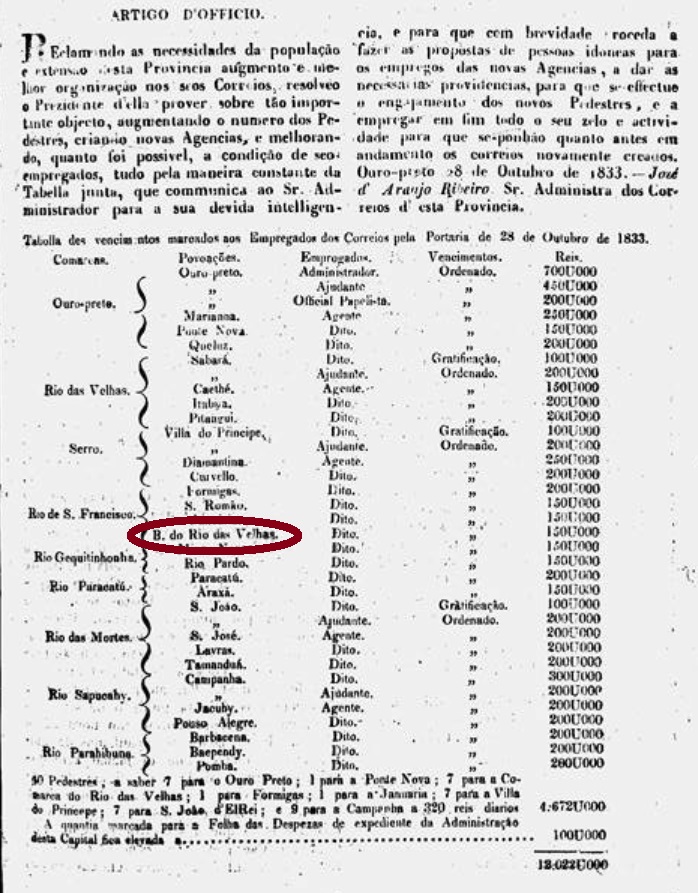
There are three dates for the creation of the post office. Nova Monteiro (Administrações e Agencias Postaes do Brasil Imperio, in Brasil Filatelico/RJ, 1934-5; Reprint SPP 1994-1999) writes October 28, 1833 for Rio das Velhas (without Barra), whereas Paula Sobrinho (História Postal de Minas Gerais, Belo Horizonte, 1997) reports the October 20, 1858 for Guaicuhy, and the Imperial Mail Register (Tabella das Agencias do Correio do Império) of 1885 lists 1879 for Guacuhy. Apparently this agency has been twice closed.
Nova Monteiro’s reference is surely related to the list of all post offices in Minas Gerais of that date, which was published one month later:
O Universal, November 13, 1833
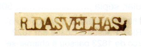
Here it is quite clear that there was an agency in Barra do Rio das Velhas, whereas the Rio das Velhas in the left column refers to a comarca, e.g. an administrative district with four post offices (Sabará, Caethé, Itabira and Pitangui). And it is also very clear that the Barra office undoubtedly must refer to the pre-philatelic cancel RMG-2123a, as presented by the RHM catalogue:
RMG-2123a, P-MG-54 (RHM)
Later cancels from Guaicuhy were already presented by R. Koester (Carimbologia XXI).
Atlas do Império do Brasil, 1868
Buchtext-Aktualisierung vom 17. Mai 2020
Andere Namen: Barra do Rio das Velhas, Guacuhy
Siehe auch Guaicuhy (R. Koester: Carimbologia XXI)
Im kaiserlichen Minas Gerais gab es zwei Flüsse, die Rio das Velhas (= Fluss der Alten Frauen) hießen. Der erste ist der heutige Rio Araguari, der seine Quelle in der Serra da Canastra im Südwesten der Provinz hat, und von dort in Richtung Westen bis zur Mündung in den Paranaíba fließt. Der zweite Rio das Velhas ist historisch viel wichtiger, denn er durchquert die Gebiete, die Politik und Wirtschaft der Region bestimmt haben. Dieser Fluss entspringt den Bergen um der Hauptstadt Ouro Preto und machr seinen 800 km langen Weg nach Nordwesten, bis er den Rio São Francisco erreicht.
An dieser Flussmündung gab es die in 1839 gegründete Freguesia von Nossa Senhora do Bom Sucesso e Almas da Barra do Rio das Velhas. Diese wurde im November 1861 zur Villa de Guaicuhy, und unter diesem Namen ist die Ortschaft heute ein Distrikt des Município von Várzea da Palma.
Drei Daten für die Gründung des Postamtes sind überliefert. Nova Monteiro (Administrações e Agencias Postaes do Brasil Imperio, in Brasil Filatelico/RJ, 1934-5; Reprint SPP 1994-1999) schreibt den 28. Oktober 1833 für Rio das Velhas (ohne Barra), während Paula Sobrinho (História Postal de Minas Gerais, Belo Horizonte, 1997) gibt den 20. Oktober 1858 für Guaicuhy, und das Verzeichnis der kaiserlichen Postämter (Tabella das Agencias do Correio do Império) von 1885 listet das Jahr 1879 für Guacuhy. Scheinbar wurde das Postamt also zweimal geschlossen.
Nova Monteiros Angabe basiert sicherlich auf eine damalige Liste aller Postämter in Minas Gerais, die im November 1833 veröffentlicht wurde:
O Universal, 13. November 1833
Hier geht klar hervor, dass ein Postamt in Barra do Rio das Velhas aktiv war, während der Rio das Velhas in der linken Spalte eine comarca ist, also ein Verwaltungsbezirk, wo man vier Postämter (Sabará, Caethé, Itabira and Pitangui) aufgelistet hat. Es ist auch ziemlich klar, dass das Barra-Postamt fast zwangsläufig mit dem Vorphila-Stempel RMG-2123a zu tun hat, wie im RHM-Katalog abgebildet:
RMG-2123a, P-MG-54 (RHM)
Spätere Abstempelungen unter Guaicuhy wurden bereits durch R. Koester (Carimbologia XXI) vorgestellt.
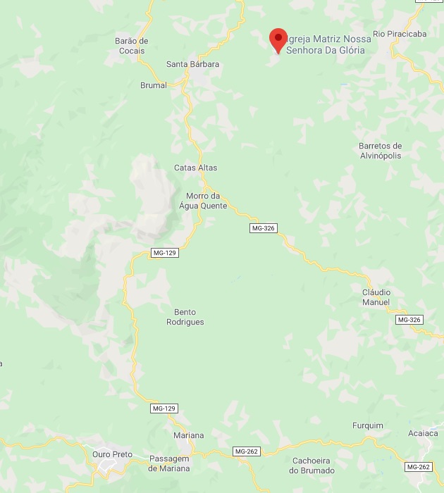
This is not the famous and mythical, over three thousand km long river which crosses both Minas Gerais and Bahia and divides Alagoas and Sergipe before reaching the Atlantic Ocean. It is a rather tiny homonymous colleague, barely visible on the map, an affluent to the Piracicaba River which gave the name to a district of the municipality of Santa Barbara, situated over 80 km north of the province capital Ouro Preto.
Rio de São Francisco was at least three times elevated to a district: in 1846, 1859 and 1873. It has kept this status until our days, but since September 1923 it is called Florália.
According to Paula Sobrinho (História Postal de Minas Gerais, Belo Horizonte, 1997), the post office was created in June 1876. Two imperial cancels are known. RMG-2130a (Coll. José A. Junges) has a double circle with the inscription R. DE S. FRANCISCO above and the date in the centre. Exemplars found used 1878-1887. RMG-2130b (Coll. José A. Junges) has a double circle with the inscription RIO DE S. FRANCISCO in somewhat bigger letters above and a cross ornament below, which consists of four diamonds. The dates are also here inside, known copies used from 1888 until 1890.
Google Maps
Dieser ist nicht der mythische, berühmte Fluss mit über dreitausend km Länge, der sowohl Minas Gerais als auch Bahia durchquert und Alagoas von Sergipe trennt, bevor er in die Atlantik mündet. Dieser ist ein eher kleiner Kollege, kaum auffindbar auf der Karte, der in den Piracicaba einfließt und seinen Namen einem Distrikt des Município von Santa Barbara gab, über 80 km nördlich der Provinzhauptstadt Ouro Preto gelegen.
Rio de São Francisco wurde mindestens dreimal zum Distrikt ernannt: in 1846, 1859 und zuletzt in 1873. Diesen Status erhielt die Ortschaft bis heute, allerdings – seit September 1923 – unter dem Ortsnamen Florália.
Laut Paula Sobrinho (História Postal de Minas Gerais, Belo Horizonte, 1997) entstand das Postamt im Juni 1876. Zwei Stempel aus dem Kaisserreich sind überliefert. RMG-2130a (Samml. José A. Junges) hat einen Doppelkreis mit der Inschrift R. DE S. FRANCISCO oben und dem Datum in der Mitte. Die gefundenen Exemplare wurden 1878-1887 benutzt. RMG-2130b (Samml. José A. Junges) hat einen Doppelkreis mit der Inschrift RIO DE S. FRANCISCO in etwas größeren Buchstaben wie vor oben, dazu ein kreuzförmiges Ornament unten, das aus vier kleinen Rhomben besteht. Auch hier sind die Daten (Exemplare benutzt 1888-1890) in der Mitte.
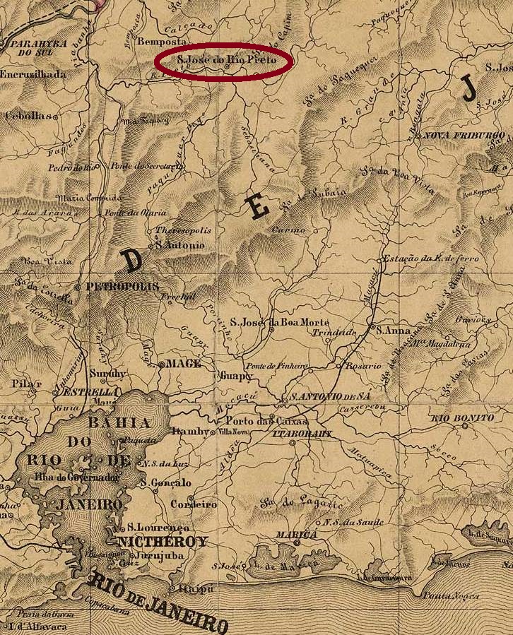
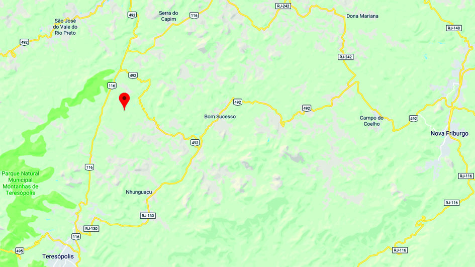
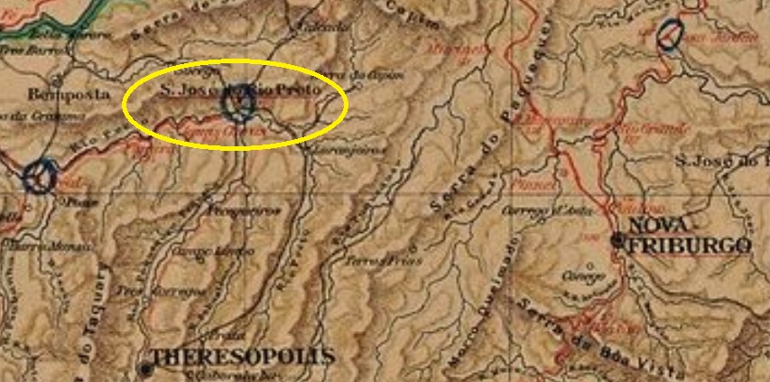
This Rio Preto (= Black River) emerges from the Serra with the same name, in northern Rio de Janeiro province. Recent researches have brought into light that this locality may be identical with São José do Rio Preto (RRJ-1460). So will the post office and its cancels be discussed there, as long as no cancels appears featuring only RIO PRETO.
Google Maps
Buchausgabe-Textaktualisierung vom 16. Mai 2020
Dieser Rio Preto (= Schwarzer Fluss) entspringt dem gleichnamigen Gebirge im Norden der Provinz Rio de Janeiro. Aktuelle Forschungsergebnisse deuten darauf an, dass diese Ortschaft identisch mit São José do Rio Preto (RRJ-1460) sein kann. Dadurch werden Postamt und Stempel dort besprochen, solange kein Stempel auftaucht, wo nur RIO PRETO zu lesen ist.
This is another mysterious post office at the end of the Brazilian Empire which appeared after the publishing of Carimbologia (Q-R) and apparently remained active only for a short time. The Rio Preto station of the Estrada de Ferro Príncipe do Grão-Pará (not the Rio Preto station of the Companhia Estrada de Ferro União Valenciana, at the border with Minas Gerais) was built in November 1886 as the final stop of the Areal-S. José do Rio Preto Branch. As the name reveals, it was located on the east bank of the Rio Preto, which flows from the mountains between Teresópolis and Nova Friburgo into the Piabanha River. The railroad went in 1890 to the Estrada de Ferro Leopoldina and stopped operations in 1947. Now both tracks and station are removed (estacoesferroviarias.com.br).
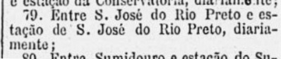
The earliest mention of a post office in the station was found in the Rio press in November 1888. A mail courier line (#79) was supposed to operate between the Rio Preto train station and the Villa of São José do Rio Preto. This could mean the station post office was opened around that time:
Gazeta de Noticias, November 6, 1888
Thanks to the philatelist Paulo Novaes, who provided the image above and helped decisively on the disambiguation of the Rio Preto train stations in Rio de Janeiro.
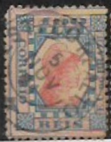
We don’t know either when it was closed, but since a single cancel, RRJ-2044a (image: Filatélica Minas Gerais-stamp auction) has been found with date November 5, 1891, we presume the post office has operated at least two years long:
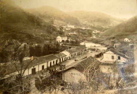
RRJ-2044aca.1940 (Photo P.P. Resende, apud estacoesferroviarias.com.br)
Textaktualisierung vom 16. Juni 2020
Hier haben wir wieder ein rätselhaftes Postamt aus der Spätzeit des Kaiserreichs, das nach dem Erscheinen von Carimbologia (Q-R) aufgetaucht ist und scheinbar eine kurze Betriebsdauer erlebte. Der Bahnhof Rio Preto der Estrada de Ferro Príncipe do Grão-Pará (nicht der Bahnhof Rio Preto der Companhia Estrada de Ferro União Valenciana, an der Grenze zu Minas Gerais) wurde im November 1886 gebaut, als Endstation der Areal-S. José do Rio Preto-Abzweigung. Wie der Name schon sagt, lag er am Ostufer des Rio Preto, der in den Bergen zwischen Teresópolis und Nova Friburgo entspringt und in den Fluss Piabanha mündet. Die Bahnlinie ging 1890 in Besitz der Estrada de Ferro Leopoldina über und beendete den Betrieb in 1947. Nun sind Schienen und Bahnhaus entfernt (estacoesferroviarias.com.br).
Die früheste Erwähnung eines Bahnhofspostamts in Rio Preto wurde in der Rio-Presse mit Datum November 1888. Eine Post-Stafettenlinie sollte die Strecke zwischen dem Bahnhof Rio Preto und die Villa von São José do Rio Preto übernehmen. Das könnte bedeuten, das Bahnhofspostamt entstand um diese Zeit:
Gazeta de Noticias, 6. November 1888
Dank an den Philatelisten Paulo Novaes, der durch die obige Abbildung bei der Klärung des Sachverhalts entscheidend helfen konnte.
Wir wissen zwar weder das genaue Öffnungs- noch das Schließungsdatum, aber ein Stempel mit Datum 5. November 1891 ist inzwischen aufgetaucht: RRJ-2044a (Abb.: Filatélica Minas Gerais-Briefmarkenauktion) deutet an, das Postamt hatte mindestens zwei Jahre lang geöffnet: