Categories
Carimbologia Q-R

Rio das Ostras, Rio de Janeiro (RRJ-0845)

Atlas do Imperio do Brasil, 1868

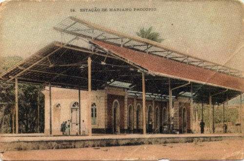
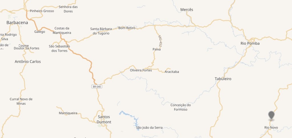
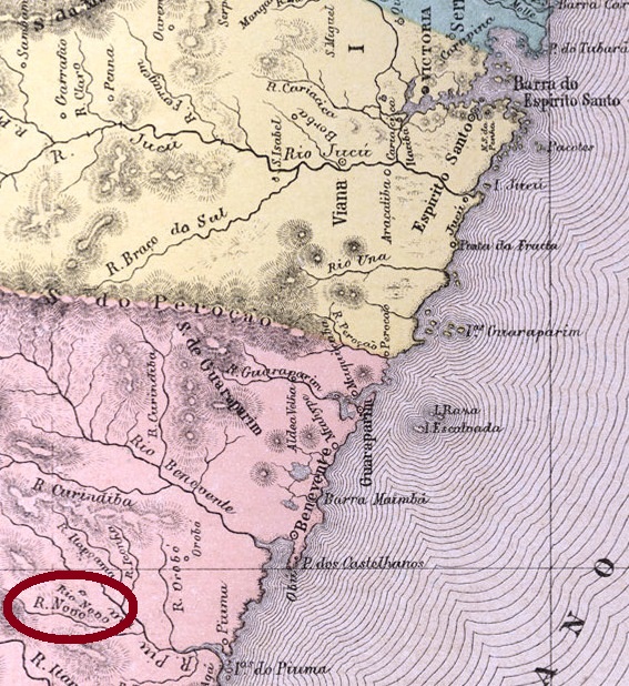
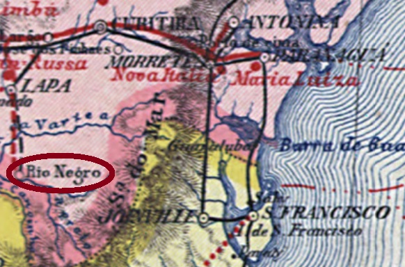
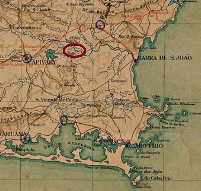
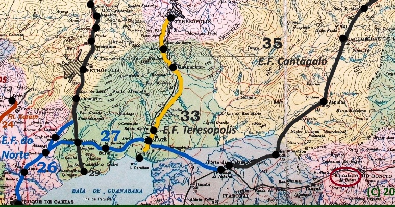
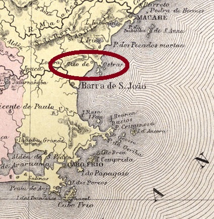
Rio das Ostras (Oysters River) was a small port at the north end of a charming bay, about 60 km away from Cabo Frio, which since 1846 belonged to the Villa of Barra de São João Baptista. It was made a Curato in 1892 and became a district of the newly created municipality of Casimiro de Abreu in March 1970, achieving the political emancipation only in April 1992.

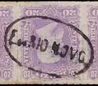
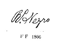
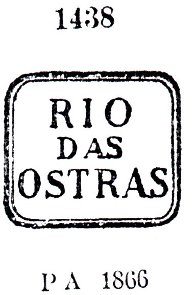
According to Nova Monteiro, the post office was created in September 1856. The first cancel, RRJ-0845a, already presented by Paulo Ayres in 1937 under #1438, was found in black, brown and blue on stamps dated until 1883:

RRJ-0845a, P. Ayres #1438

It was followed by two cancels, very similar to each other: RRJ-0845b and RRJ-0845c (Coll. José A. Junges) have both a double circle with the inscription RIO DE OSTRAS above and the date in the centre. The former is found on stamps dated ca. 1881 until 1887, while the latter has a very tiny year indication, the sole exemplar of which was used in 1883. The last imperial cancel, RRJ-0845d (Coll. José A. Junges), is similar to his predecessors, but now the inscription letters above are bigger and there is an ornament below, formed by three diamonds in line. Found dates from 1887 on.

Google Maps

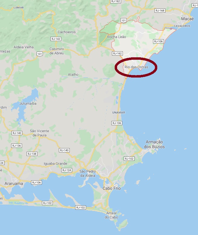
Rio das Ostras (Fluss der Austern) war ein kleiner Hafen an der Nordspitze einer lieblichen Bucht etwa 60 km nördlich von Cabo Frio gelegen, der seit 1846 der Villa da Barra de São João Baptista angehörte. In 1892 als ein Curato ernannt, wurde Rio das Ostras in März 1970 ein Distrikt des neu gegründeten Município von Casimiro de Abreu. Die politische Autonomie kam erst im April 1992, als Rio das Ostras selber ein Município wurde.

Laut Nova Monteiro stammt das Postamt aus dem September 1856. Der erste Stempel, RRJ-0845a, wurde bereits durch Paulo Ayres in 1937 unter Nr. 1438 vorgestellt. Er kommt in schwarz, braun und blau auf Marken bis 1883 vor:

RRJ-0845a, Paulo Ayres Nr. 1438

Ihm folgten zwei sehr ähnliche Stempel: RRJ-0845b und RRJ-0845c (beide Samml. José A. Junges) unterscheiden sich nur durch die wesentlich kleinere Jahresangabe beim Letzten. Sonst haben beide einen Doppelkreis mit der Inschrift RIO DE OSTRAS oben und dem Datum in der Mitte. RRJ-0845b wurde auf Marken mit Daten zwischen ca. 1881 und 1887 aufgestempelt, während vom RRJ-0845c kennen wir ein einziges Exemplar aus 1883. Der letzte Stempel der Kaiserzeit ist ähnlich wie seine Vorgänger, hat RRJ-0845d (Samml. José A. Junges) aber größere Buchstaben im Ortsnamen und ein neues Ornament unten, das aus einer Reihe von drei kleinen Rauten besteht. Gefunden mit Daten ab 1887.

Categories
Carimbologia Q-R

Rio Novo, São Paulo (RSP-1125)

Mappa da Provincia de São Paulo, 1886

Print edition update of May 2, 2020

See also: Campos Novos do Paranapanema (R. Koester: Carimbologia VIII)

There were two localities – and two post offices – called Rio Novo in the imperial province of São Paulo. The print edition of Carimbologia (Q-R) describes unfortunately the more recent one, the former São José do Rio Novo, which is now the municipality of Campos Novos Paulista. It changed the name in 1880 into Campos Novos do Paranapanema, whose post office was already presented by R. Koester in Carimbologia VIII. Further information under São José do Rio Novo (scheduled for 2021).

The older Rio Novo, about which should be spoken here, was the freguesia of Nossa Senhora das Dores do Rio Novo, created in April 1870 in the municipality of Botucatu, ca. 270 km west of the province capital. It ascended to a villa in July 1875 and to a town in May 1891, one month before it was renamed into the actual toponym Avaré. The map below shows both Rio Novo locations: The older one in red, the newer in yellow.

The Imperial Mail Register (Tabella das Agencias do Correio do Império) of 1885 lists the post office with creation date in 1875, which rather would be the year of installing this agency. An exact and earlier creation date is given by the Almanak Laemmert of 1885 among the dates for the municipality of Rio Novo:

Almanak Laemmert, 1885

Only one manuscript cancellation was found, and its attribution is uncertain. RSP-1125a (Coll. José A. Junges) was written in black on a D. Pedro emission of 1876 and could also be either from Minas Gerais (RMG-2145) or a variant of a manuscript example from Rio Negro in Paraná (RPR-0175b).

Mappa da Provincia de S. Paulo, C. Rath, 1886

Buchausgabe-Aktualisierung vom 2. Mai 2020

Siehe auch: Campos Novos do Paranapanema (R. Koester, Carimbologia VIII)

Es gab zwei Ortschaften – und daher auch zwei Postämter – in der Provinz São Paulo, die Rio Novo hießen. Leider sind in der Printausgabe der Carimbologia (Q-R) die Daten der jüngeren Alternative zu lesen, die ehemalige São José do Rio Novo, was heute den Município von Campos Novos do Paranapanema darstellt. Hierüber wurde bereits in R. Koesters Carimbologia VIII berichtet, eine Wiederaufnahme (unter São José do Rio Novo) ist für 2021 geplant.

Vom älteren Rio Novo wird also hier die Rede sein. Die alte Freguesia von Nossa Senhora das Dores do Rio Novo wurde im April 1870 im Município von Botucatu gegründet, ca. 270 km westlich von der Provinzhauptstadt São Paulo entfernt. Sie stieg zu einer Villa im Juli 1875 auf und erhielt das Stadtrecht im Mai 1891, einem Monat bevor sie den heutigen Namen Avaré erhielt. Die obere Karte zeigt beide Rio Novo-Ortschaften: die ältere in rot, die jüngere in gelb.

Das Verzeichnis der kaiserlichen Postämter (Tabella das Agencias do Correio do Império) von 1885 listet dieses Postamt mit Entstehungsjahr 1875 auf, aber dieses Jahr dürfte das von der Inbetriebnahme der Agentur sein. Ein exakteres und etwas früheres Entstehungsdatum wird bei der Beschreibung des Bezirks Rio Novo im Almanak Laemmert vom 1885 geliefert:

Almanak Laemmert, 1885

Nur eine handschriftliche Entwertung wurde gefunden, die dazu noch unsicher ist. RSP-1125a (Samml. José A. Junges) wurde in schwarz auf eine D. Pedro-Ausgabe vom 1876 geschrieben und könnte eventuell aus Minas Gerais (RMG-2145) stammen, oder auch eine Variante der handschriftliche Entwertung RPR-0175b aus Rio Negro/PR sein.

Categories
Carimbologia Q-R

Rio Novo (train station/Bahnhof), Minas Gerais (RMG-3583)

Estrada de Ferro Central do Brasil, 1890

Print edition update of July 5, 2025

See also Mariano Procopio (MMG-1570) and Fortaleza de Sant’Anna (FMG-1197)

This Rio Novo post office in imperial Minas Gerais was a station on the Estrada de Ferro D. Pedro II railway line, known as the Linha do Centro (Central Line), located just a few kilometres north of Juiz de Fora. Ralph Giesbrecht (estacoesferroviarias.com.br) writes that the station was inaugurated in November 1876. However, this date probably needs to be corrected to February 1877, as can be seen from the press in Rio de Janeiro.

Gazeta de Noticias, Rio de Janeiro, January 29, 1877

The D. Pedro II Railway Company had to change its name in November 1889 and was henceforth called Estrada de Ferro Central do Brasil. From 1975 until the end of operations in 1996, the company became Rede Ferroviária Federal S.A. In 2017, the station building still housed a cultural centre, but today it appears abandoned.

Around. 1940 (Image by Monachesi/Ferreira, on estacoesferroviarias.com.br)
In April 2024 (Google Street View)

When the railway company Cia. União Mineira opened another station called Rio Novo in the municipality of the same name (RMG-2145) in 1883, the former Rio Novo station post office in Mariano Procopio was renamed. The station itself was not renamed until around 1915.

Paula Sobrinho cites July 1881 as the year the station post office was created in História Postal de Minas Gerais (Belo Horizonte, 1977). However, as it was already listed in the imperial postal guide (Guia Postal do Império) from 1880 under number 391, this agency must have been established between 1877 and 1879. Since both the railway and postal administrations were operated from Rio de Janeiro until Juiz de Fora at that time, it was not assigned to the province of Minas Gerais here.

Guia Postal do Imperio, 1880

In the print edition of Carimbologia Q-R (2019), the only postmark is a cancellation from the railway carriage, RMG-3583a (José A. Junges collection): It has a double circle with the inscription ‘= (…) RIO NOVO =’ at the top and ‘C.’ AMB(…) at the bottom. So far, only one example from 1890 has been found. It has now been discovered that this stamp most likely originates from the Rio Novo station of the União Mineira.

Fortunately, an earlier stamp has appeared on the RHM website (oselo.com.br), which also comes in purple and is now designated RMG-3583a.

RMG-3583a (RHM) 1877ff

For postmarks with Mariano Procopio, see MMG-1570.

Estações (…) de São Paulo, Rio de Janeiro e Minas Geraes, 1880

Buchausgabe-Aktualisierung vom 5. Juli 2025

Siehe auch Mariano Procopio (MMG-1570) und Fortaleza de Sant’Anna (FMG-1197)

Dieses Postamt Rio Novo im kaiserlichen Minas Gerais war ein Bahnhof der Estrada de Ferro D. Pedro II in der sogenannten Linha do Centro (Hauptlinie) und lag nur wenige Kilometer nördlich von Juiz de Fora. Ralph Giesbrecht (estacoesferroviarias.com.br) schreibt, dass der Bahnhof im November 1876 eingeweiht wurde. Wahrscheinlich muss dieses Datum jedoch auf Februar 1877 korrigiert werden, wie aus der Presse in Rio de Janeiro zu entnehmen ist.

Gazeta de Noticias, RJ, 29. Januar 1877

Die D. Pedro II Eisenbahngesellschaft musste im November 1889 ihren Namen ändern und hieß fortan Estrada de Ferro Central do Brasil. Von 1975 bis zum Betriebsende 1996 ging die Gesellschaft in die Rede Ferroviária Federal S.A. über. Im Jahr 2017 beherbergte das Bahnhofsgebäude noch ein Kulturzentrum, aber heute scheint es verlassen zu sein.

Ca. 1940 (Abb. Monachesi/Ferreira, auf estacoesferroviarias.com.br)
Im April 2024 (Google Street View)

Da die Bahngesellschaft Cia. União Mineira 1883 einen anderen Bahnhof Rio Novo im gleichnamigen Município (RMG-2145) eröffnete, wurde das frühere Bahnhofspostamt Rio Novo in Mariano Procopio umbenannt. Der Bahnhof selbst wurde erst um 1915 umbenannt.

Paula Sobrinho nennt in História Postal de Minas Gerais (Belo Horizonte, 1977) den Juli 1881 als Entstehungsjahr des Bahnhofspostamts. Da dieses jedoch bereits im kaiserlichen Postführer (Guia Postal do Império) aus dem Jahr 1880 unter der Nummer 391 aufgeführt wurde, muss diese Agentur zwischen 1877 und 1879 errichtet worden sein. Da sowohl die Bahn- als auch die Postverwaltung bis Juiz de Fora damals von Rio de Janeiro aus betrieben wurde, wurde sie hier nicht der Provinz Minas Gerais zugeordnet.

Guia Postal do Imperio, 1880

In der Printausgabe der Carimbologia Q-R (2019) ist der einzige Poststempel eine Entwertung aus dem Bahnwaggon, RMG-3583a (Sammlung José A. Junges): Er hat einen Doppelkreis mit der Inschrift „= (…) RIO NOVO =” oben und „C.”. AMB(…) unten. Bislang wurde nur ein Exemplar aus dem Jahr 1890 gefunden. Nun stellte sich heraus, dass dieser Stempel höchstwahrscheinlich aus dem Rio Novo-Bahnhof der União Mineira stammt.

Erfreulicherweise ist dafür ein früherer Stempel auf der RHM-Website (oselo.com.br) aufgetaucht, der auch in Lila vorkommt und jetzt als RMG-3583a bezeichnet wird.

RMG-3583a (RHM) 1877ff

Categories
Carimbologia Q-R

Rio Novo, Minas Gerais (RMG-2145)

Atlas do Imperio do Brasil, 1868

There were at least two Rio Novo post offices in the imperial province of Minas Gerais. This one is supposed to be the elder agency. It originated in March 1846 as the freguesia de Nossa Senhora da Conceição do Rio Novo in the municipality of São João Nepomuceno, about 240 km south of the former capital Ouro Preto. In 1850 the name was changed to Nossa Senhora Aparecida do Rio Novo, which went in 1860 to the municipality of Mar d’Hespanha. In September 1870, Rio Novo ascended to a Villa with administrative independence; one year later it was given the town status.

According to Paula Sobrinho (História Postal de Minas Gerais, Belo Horizonte, 1997), the post office was created in November 1863. The earliest cancel, RMG-2145a (Coll. José A. Junges) presents the inscription CORREIO DO RIO NOVO embellished by ornamental surroundings. It can be found on numeral emissions of 1850ff, and is not registered by Paulo Ayres. The following obliteration, RMG-2145b (Coll. José A. Junges), was found only once in violet on a cover with D. Pedro emissions of 1866 and shows solely Rio Novo.

RMG-2145b

RMG-2145c (Coll. José A. Junges) has a double circle with the inscription RIO NOVO above and the date in the centre. A single copy found, dated 1879. RMG-2145d (Coll. José A. Junges) is almost identical to the former but has also a (2) between circles below. Exemplars found with dates 1884-1886. The last imperial cancel is RMG-2145e (Coll. José A. Junges); it is similar to both precedent ones, but shows (MINAS) between circles below. Used between 1887 and 1896.

Wikimedia

Es gab mindestens zwei Postämter in der kaiserlichen Provinz Minas Gerais, die Rio Novo hießen. Das älteste davon war in der im März gegründeten Freguesia de Nossa Senhora da Conceição do Rio Novo im Município von São João Nepomuceno, etwa 240 km südlich der ehemaligen Hauptstadt Ouro Preto entfernt. In 1850 wurde der Name auf Nossa Senhora Aparecida do Rio Novo geändert, das dann in 1860 dem Município von Mar d’Hespanha zugeordnet wurde. Im September 1870 stieg Rio Novo zu Villa mit eigener Autonomie, ein Jahr später wurde das Stadtrecht anerkannt.

Laut Paula Sobrinho (História Postal de Minas Gerais, Belo Horizonte, 1997) entstand das Postamt im November 1863. Die früheste Abstempelung, RMG-2145a (Samml. José A. Junges) zeigt die Inschrift CORREIO DO RIO NOVO, verziert durch Ornament-Ränder. Anzutreffen auf Zifferausgaben von 1850ff, aber nicht in Paulo Ayres (Catálogo de Carimbos – Brasil Império, São Paulo, 1937) registriert. Die Nachfolgerin, RMG-2145b (Samml. José A. Junges), wurde ein einziges Mal gefunden, in violett auf einem Brief mit zwei D. Pedro-Ausgaben von 1866, und zeigt lediglich Rio Novo.

RMG-2145b

RMG-2145c (Samml. José A. Junges) hat einen Doppelkreis mit der Inschrift RIO NOVO oben und das Datum in der Mitte. Auch einmal gefunden, mit Datum 1879. RMG-2145d (Samml. José A. Junges) ist fast identisch mit dem Vorgänger, hat aber auch eine (2) unten zwischen den Kreisen. Exemplare mit Daten 1884-1886 gefunden. Der letzte Stempel der Kaiserzeit ist RMG-2145e (Samml. José A. Junges); ähnlich wie die beiden zuvor, aber zeigt diesmal (MINAS) unten zwischen den Kreisen. Benutzt 1887-1896.

Categories
Carimbologia Q-R

Rio Novo, Espírito Santo (RES-0135)

Mappa Geral da Provincia do Espirito Santo, C.Krauss, 1865

Rio Novo was a colony settlement project organized by the Empire and the province of Espírito Santo along the homonymous river in the municipality of Itapemerim. It was founded in December 1854, but the first 12 families arrived from Switzerland only in 1856. In April 1883, it ascended to a freguesia, and was made a villa with own municipality in November 1893. In December 1943 a new toponym was given: Itapoama, which means Beautiful Stone in the tupi-guarani Indian language. But apparently the inhabitants have not approved the name, so was the municipality renamed to Rio Novo do Sul ten years later.

According to Paulo Novaes (agenciaspostais.com.br), the local post office was created in February 1882, but the agency name switched from Colônia to Rio Novo only in 1885, two years after the elevation to freguesia. The first cancel, RES-0135a, was found in black and blue until ca. 1882 and already presented by Paulo Ayres (op. cit., 1937) under #1437:

RES-0135a, Paulo Ayres #1437

It was followed by RES-0135b (Coll. José A. Junges), that shows a double circle, of which the external one is doubled, the inscription CORRo. DO RIO=NOVO above and a horizontal diamond ornament below, which is formed by four little diamonds. Dates in the centre, found between 1885 and 1888.

Atlas do Imperio do Brasil, 1868

Rio Novo war ein Siedlungsprojekt für europäische Kolonisten, die vom Kaiserreich und der Provinzregierung von Espírito Santo organisiert wurde. Es lag am gleichnamigen Fluss im Município von Itapemerim und wurde im Dezember 1854 gegründet, die ersten 12 Siedlerfamilien aus der Schweiz kamen aber erst in 1856 an. Im April 1883 wurde Rio Novo eine Freguesia, und im November 1893 eine eigenständige Villa. Im Dezember wurde der Ortschaft der Indianername Itapoama (= Schöner Stein, in der tupi-guarani-Sprache). Scheinbar kam die neue Bezeichnung bei den Einwohnern nicht gut an, denn zehn Jahre später wurde der Name abermals geändert. Und bis heute heißt der Município Rio Novo do Sul.

Laut Paulo Novaes (agenciaspostais.com.br) entstand das dortige Postamt im Februar 1882, und die Agentur wechselte den Namen (von Colonia zu Rio Novo) erst in 1885, zwei Jahre nach dem Aufstieg zur Freguesia. Der erste Ortsstempel, RES-0135a, wurde in schwarz und blau bis ca. 1882 gefunden und wurde bereits durch Paulo Ayres (op. cit., 1937) unter Nr. 1437 vorgestellt:

RES-0135a, Paulo Ayres Nr. 1437

Ihm folgte RES-0135b (Samml. José A. Junges). Dieser zeigt einen Doppelkreis, dessen Außenkreis wiederum verdoppelt wird, die Inschrift CORRo. DO RIO=NOVO oben und ein waagerechtes Ornament in Rautenform unten, das aus vier kleinen Rauten besteht. Daten in der Mitte, gefunden zwischen 1885 und 1888.

Categories
Carimbologia Q-R

Rio Negro, Paraná (RPR-0175)

Atlas do Imperio do Brasil, 1868

Rio Negro is today a town with about 35 thousand inhabitants on the north bank of the river with the same name, which separates the states Paraná and Santa Catarina. The locality is situated a hundred km southwest of Curitiba and was made a freguesia of the Lapa municipality as early as 1838, when Paraná still belonged to São Paulo. In 1879 it arose to a Villa, and in 1896, already in the republic, it was made a town.

The Imperial Mail Register (Tabella das Agencias do Correio do Império) of 1885 lists the post office with creation date in 1857, but in June 1861 it was closed again, as reported by the official press:

Expediente do Ministerio da Agricultura, 21/06/1861

The reopening of the post office was announced in March 1863:

Dezenove de Dezembro, March 18, 1863

Four different cancellations were found, two of them manuscript, but unfortunately none from the short early period of this office. RPR-0175a (Coll. Karlheinz Wittig) features Rio Negro written with black pen on a D. Pedro emission of 1866. RPR-0175b (Coll. José A. Junges) shows a slight reduction of the former, with a manuscript R.o Negro, also in black and on a D. Pedro of 1866. This is probably the cancel shown by Paulo Ayres (Catálogo de Carimbos – Brasil Império, São Paulo, 1937) on page 147:

P. Ayres, op. cit.

The clerk who wrote both cancels might be the same, for the calligraphy is very similar, easily recognizable through the scroll at the beginning of letter N. RPR-0175c (Coll. José A. Junges) is a double circle with RIO NEGRO above and the date in the centre. Found on stamps used between 1877 and 1889. Finally, RPR-0175d (Coll. José A. Junges) could be already republican, for it was seen just once, dated of June 1890. It shows a double circle with imprints RIO-NEGRO above and (PARANÁ) below, dated in the centre.

Carta da Republica dos Estados Unidos do Brazil, 1892

Heute ist Rio Negro ein Städtchen mit ca. 35 Tausend Einwohnern am Nordufer des gleichnamigen Flusses, der als Grenze zwischen den Bundesstaaten Paraná und Santa Catarina fungiert. Die Ortschaft liegt etwa 100 km südwestlich von der Hauptstadt Curitiba entfernt und wurde bereits in 1838 eine Freguesia, zu einer Zeit, als Paraná noch ein Teil der Provinz São Paulo war. In 1879 stieg Rio Negro zu einer Villa auf, und in 1896, schon in der Republik, erhielt der Ort das Stadtrecht.

Das Verzeichnis der kaiserlichen Postämter (Tabella das Agencias do Correio do Império) von 1885 listet dieses Postamt mit Entstehungsjahr 1857 auf, aber im Juni 1861 wurde es wieder geschlossen, wie die Amtspresse meldete:

Expediente do Ministerio da Agricultura, 21.06.1861

Die Wiedereröffnung des Postamts wurde im März 1863 bekannt gegeben:

Dezenove de Dezembro, 18. März 1863

Vier verschiedene postalische Entwertungen – zwei davon handschriftlich – sind von dieser Agentur überliefert, leider keine davon aus der Frühzeit ab 1857. RPR-0175a (Samml. Karlheinz Wittig) hat Rio Negro mit der Hand in schwarzer Tinte auf eine D. Pedro-Ausgabe von 1866 geschrieben. RPR-0175b (Samml. José A. Junges) zeigt eine kleine Abkürzung vom Vorgänger, mit einem handgeschriebenen R.o Negro, auch in schwarz und auf einen D. Pedro aus 1866. Dieser ist wahrscheinlich der Stempel, den Paulo Ayres im Catálogo de Carimbos – Brasil Império (São Paulo, 1937) auf S. 147 gezeigt hat:

Paulo Ayres, op.cit.

Der Beamte, der beide Marken beschriftet hat, könnte derselbe sein, denn die Kalligrafie ist sehr ähnlich, leicht durch den Anfangsschnörkel vom Buchstabe N zu erkennen. RPR-0175c (Samml. José A. Junges) ist ein Doppelkreis mit RIO NEGRO oben und dem Datum in der Mitte. Gefunden auf Marken, die zwischen 1877 und 1889 benutzt wurden. Der Letzte, RPR-0175d (Samml. José A. Junges), könnte bereits republikanisch sein, da er nur einmal auf eine Marke mit Datum Juni 1890 gesichtet wurde. Es zeigt einen Doppelkreis mit den Inschriften RIO-NEGRO oben und (PARANÁ) unten, dazu das Datum in der Mitte.

Categories
Carimbologia Q-R

Rio das Mortes (train station/Bahnhof), Minas Gerais (RMG-2120)

Carta da Republica dos Estados Unidos do Brazil, 1892

The Rio das Mortes (= River of the Deaths) here is neither the big one which flows from Mato Grosso into the Araguaia River nor the other one that titled R.W. Fassbinder’s film in 1971. Instead, it is a rather short one in a Brazilian scale, with less than 300 km extension. It emerges from the Serra da Mantiqueira in southern Minas Gerais and flows west until reaching the Furnas water reservoir near Ijaci. In spite of having been scenery to the Emboabas War (1707-09), the river name derives from the many deaths among people who tried to pass it by swimming in order to avoid the toll, at the end of 17th century. (Wikipedia)

The Rio das Mortes station was inaugurated in May 1887 by the Estrada de Ferro Oeste de Minas railway, in the so called Paraopeba Line, situated at that time in the municipality of São João d’El Rey. In 1908 the name was changed to João Pinheiro station, celebrating a Minas Gerais politician. From 1931 until 1965 the railway belonged to the Rede Mineira de Viação. In 1943, the train station was given again a new name: Congo Fino, which is a locality with African origin situated north of the actual town of Conceição da Barra de Minas. From 1965 until 1975 the railway passed to the Viação Férrea Centro-Oeste, before changing once more, to the Rede Ferroviária Federal S.A. from 1975 until 1984. (estacoesferroviarias.com.br). Now the station is demolished, and the rails have been removed.

According to Paula Sobrinho (História Postal de Minas Gerais, Belo Horizonte, 1997), the station post office was created in December 1887, and the first clerk was nominated already on December 20:

A Provincia de Minas, January 5, 1888

One imperial cancel is known: RMG-2120a (Coll. José A. Junges) has a double circle with the inscriptions EST. DO RIO DAS MORTES above and (MINAS) below, with the date in the centre. Exemplars have been found with dates between 1887 and 1902.

Município de Conceição da Barra de Minas

Der Rio das Mortes (= Fluss der Todesfälle) hier ist weder sein großer Bruder, der von Mato Grosso kommend in den Araguaia fließt, noch sein fiktiver Namesvetter aus dem gleichnamigen Film von R.W. Fassbinder aus 1971. Stattdessen ist er ein für brasilianische Verhältnisse eher kleiner Kollege mit knapp 300 km Länge, der in der Serra da Mantiqueira im Süden von Minas Gerais entspringt, und nach Westen bis in den Furnas-Staudamm bei Ijaci fließt. Obwohl der Fluss die Szenerie für den blutigen Emboabas-Krieg (1707-09) stellte, gründet sein grausiger Name angeblich aus den vielen Todesfällen unten den Reisenden im späten 17. Jahrhundert, die ihn durchschwimmen wollten, ohne Maut zu bezahlen. (Wikipedia)

Der Bahnhof Rio das Mortes wurde im Mai 1887 durch die Estrada de Ferro Oeste de Minas, in der so genannten Paraopeba Linie, eingeweiht, und lag damals im Município von São João d’El Rey. In 1908 wechselte der Name zu João Pinheiro, um einem Politiker aus Minas Gerais die Ehre zu erweisen. Von 1931 bis 1965 gehörte die Bahnlinie der Rede Mineira de Viação. In 1943 wurde der Bahnhof abermals umbenannt: auf Congo Fino, wie die Ortschaft nördlich vom Städtchen und Verwaltungssitz Conceição da Barra de Minas heißt. Von 1965 bis 1975 wechselte der Bahnbesitz zur Viação Férrea Centro-Oeste, bevor er Eigentum der Rede Ferroviária Federal S.A. (1975-1984) wurde. (estacoesferroviarias.com.br). Nun ist das Bahnhaus abgerissen, und auch die Schienen wurden entfernt.

Laut Paula Sobrinho (História Postal de Minas Gerais, Belo Horizonte, 1997), entstand das Bahnhofspostamt im Dezember 1887; und der erste Postangestellte wurde am 20. d. Mts. ernannt:

A Provincia de MInas, 5. Januar 1888

Ein Stempel der Kaiserzeit ist überliefert: RMG-2120a (Samml. José A. Junges) hat einen Doppelkreis mit den Inschriften EST. DO RIO DAS MORTES oben und (MINAS) unten, dazu das Datum in der Mitte. Exemplare wurden mit Daten zwischen 1887 und 1902 gefunden.

Categories
Carimbologia Q-R

Rio Morto, Rio de Janeiro (RRJ-2637) NEW/NEU

Almanak Laemmert, 1892

This is the most mysterious post office discovered after the publishing of Carimbologia (Q-R), for its creation was announced twice, but there is neither an existing cancel nor a listing in any postal record. The Rio Morto (= Dead River) flows from the slopes of the Serra da Boa Esperança toward north into the Rio São João, near the actual Juturnaíba water reservoir, about 150 km east of Rio de Janeiro.

The former locality of Rio Morto was situated on the river with the same name near Aldeia Velha in the freguesia of Nossa Senhora da Conceição do Amparo das Correntezas, which belonged to the former municipality of Capivary (today: Silva Jardim).

The first announcement of a post office in Rio Morto was made in July 1884:

Gazeta da Tarde, July 29, 1884

However, the new agency was not listed in the Imperial Mail Register (Tabella das Agencias do Correio do Império) of the following year, probably because it hadn’t started operations yet. Anyway, a second creation was announced in at least four Rio de Janeiro newspapers in January 1886:

A Vanguarda, January 13, 1886

From then on, no record has been found anymore, either about the post office, or about the locality, which seems to have disappeared from every map. Probably this agency has never operated.

Google Maps

Dieses ist das rätselhafteste Postamt, das seit der Veröffentlichung von Carimbologia Q-R entdeckt wurde. Denn seine Entstehung wurde zwar zweimal angekündigt, dennoch gibt es weder irgendeine Postabstempelung, noch wird das Postamt in irgendwelchem Verzeichnis aufgelistet. Der Rio Morto (= Toter Fluss) fließt von den Hängen der Serra da Boa Esperança nach Norden bis zum Rio São João, in der Nähe des heutigen Juturnaíba-Staudamms, etwa 150 km östlich von Rio de Janeiro entfernt.

Die alte Siedlung namens Rio Morto war sicher am gleichnamigen Fluss gelegen, nahe Aldeia Velha in der Freguesia Nossa Senhora da Conceição do Amparo das Correntezas, die dem Município von Capivary (heute: Silva Jardim) angehörte.

Ein Postamt wurde dort erstmals im Juli 1884 angekündigt:

Gazeta da Tarde, 29. Juli 1884

Gleichwohl war diese Agentur nicht im Verzeichnis der kaiserlichen Postämter (Tabella das Agencias do Correio do Império) vom darauf folgenden Jahr zu sehen, wohl weil der Postbetrieb zum Redaktionsschluss noch nicht gestartet war. Wie es dem auch sei, das Postamt wurde im Januar 1886 gleich durch mindestens vier Zeitungen zum zweiten Mal angekündigt:

A Vanguarda, 13. Januar 1886

Von nun an gab es keine Meldungen mehr, weder über das Postamt noch über die Ortschaft selber, die von der Karte verschwunden zu sein scheint. Wahrscheinlich wurde dieses Postamt niemals betrieben, aber wer weiß?

Categories
Carimbologia Q-R

Rio Manso, Minas Gerais (RMG-2140)

Atlas do Imperio do Brasil, 1868

Other name: Rio Manso de Diamantina

In Imperial Minas Gerais there were two important localities called Rio Manso (= Tame River). The first and older one was the freguesia of Santa Luzia do Rio Manso at Piedade do Paraopeba, later a district of the municipality of Bonfim. Since Paula Sobrinho (História Postal de Minas Gerais, Belo Horizonte, 1997) informs us that here the post office was created only in 1894, we must focus on the second one.

This was the freguesia of Nossa Senhora da Conceição do Rio Manso in the municipality of Diamantina, established in June 1853 and situated over 250 km north from the former capital Ouro Preto. Since 1938 it is the municipality of Couto de Magalhães de Minas.

There are two different dates for the creation of the local post office. It is listed in the Imperial Mail Register (Tabella das Agencias do Correio do Império) of 1885 with creation year of 1880, whereas Paula Sobrinho (op. cit.) states the exact date of November 8, 1881.

Only one imperial cancel is known: RMG-2140a (Coll. José A. Junges) has a double circle with the inscription RIO MANSO above and a foliated ornament below, with four leaves in cross, each of which containing three leaflets. Dates found for 1886.

Google Maps

Anderer Name: Rio Manso de Diamantina

Es gab zwei wichtige Ortschaften im kaiserlichen Minas Gerais, die Rio Manso (= Zahmer Fluss) hießen. Die erste und ältere war die Freguesia von Santa Luzia do Rio Manso bei Piedade do Paraopeba, die später ein Distrikt von Bonfim wurde. Da diese Ortschaft ihr Postamt erst in der Republik erhielt, laut Paula Sobrinho (História Postal de Minas Gerais, Belo Horizonte, 1997), wird hier vom zweiten Rio Manso die Rede sein.

Diese war die Freguesia von Nossa Senhora da Conceição do Rio Manso im Bezirk Diamantina, gegründet im Juni 1853 über 250 km nördlich von der früheren Hauptstadt Ouro Preto entfernt. Seit 1938 ist es der Município von Couto de Magalhães de Minas.

Es sind zwei Daten für die Entstehung des Postamts überliefert. Im Verzeichnis der kaiserlichen Postämter (Tabella das Agencias do Correio do Império) von 1885 heißt es das Jahr 1880; während Paula Sobrinho (op. cit.) das exakte Datum 8. November 1881 nennt.

Dafür gibt es bisher nur einen bekannten Stempel aus der Kaiserzeit: RMG-2140a (Samml. José A. Junges) hat einen Doppelkreis mit der Inschrift RIO MANSO oben und ein Blattornament unten, mit vier Blättern in Kreuzform, und jedes Blatt besteht aus drei Blättchen. Daten fürs Jahr 1886 gefunden.

Categories
Carimbologia Q-R

Rio dos Indios (train station/Bahnhof), Rio de Janeiro (RRJ-2635)

agenciaspostais.com.br

The train station of Rio dos Indios (= Indian River) was inaugurated on June 21, 1879 by the Companhia de Ferro-Carril Niterioense railway in the so called “Coast Line” (Linha do Litoral) in the municipality of Rio Bonito, ca. 70 km east from Rio de Janeiro. In 1887 the line changed for some months to the Estrada de Ferro de Macaé a Campos, before passing to the Estrada de Ferro Leopoldina in the same year. From 1975 until 1996 the line belonged to the Rede Ferroviária Federal, but the train station was already demolished in 1970 (estacoesferroviarias.com.br).

According to Paulo Novaes (agenciaspostais.com.br), the post office was created on the very same day of the inauguration, which was quite unusual. The first cancel, RRJ-2635a, was already presented by Paulo Ayres in 1937, under #1436:

RRJ-2635a, Paulo Ayres # 1436

It was followed by RRJ-2635b (Coll. José A. Junges): a double circle with the inscription RIO DOS INDIOS above and the date in the centre. The exemplars found so far have dates between 1888 and 1891.

Estrada de Ferro Leopoldina

Der Bahnhof Rio dos Indios (=Indianerfluss) wurde am 21. Juni 1879 dem Publikum durch die Eisenbahngesellschaft Companhia de Ferro-Carril Niterioense vorgestellt. Er gehörte zur so genannten „Küstenlinie“ (Linha do Litoral) im Bezirk Rio Bonito, etwa 70 km östlich von Rio de Janeiro. In 1887 die Bahnlinie gehörte für ein Paar Monate zur Estrada de Ferro de Macaé a Campos, bevor sie Eigentum der Estrada de Ferro Leopoldina wurde. Von 1975 bis 1996 hat die Rede Ferroviária Federal zwar den Betrieb übernommen, aber der Bahnhof Rio dos Indios war schon seit 1970 abgerissen.

Laut Paulo Novaes (agenciaspostais.com.br) wurde das Bahnhofspostamt am Tag der Bahnhofseinweihung auch eröffnet, was eigentlich sehr unüblich war. Der erste Stempel, RRJ-2635a, wurde bereits durch Paulo Ayres in 1937 unter Nr. 1436 vorgestellt:

RRJ-2635a, Paulo Ayres Nr. 1436

Sein Nachfolger, RRJ-2635b (Samml. José A. Junges), hat einen Doppelkreis mit der Inschrift RIO DOS INDIOS oben und dem Datum in der Mitte. Die gefundenen Exemplare datieren zwischen 1888 und 1891.