Other names: Maniçoba, São José do Belmonte (1953)
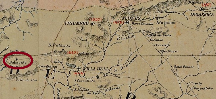
São José do Bello Monte (= on the beautiful mountain) was a district of Villa Bella (now Serra Talhada) about 470 km west of the provincial capital Recife. In June 1893, the village rose to a villa in own municipality. In 1943, the place changed its name to Maniçoba (the regional name for the cassava root) and in 1953 to the current São José do Belmonte.
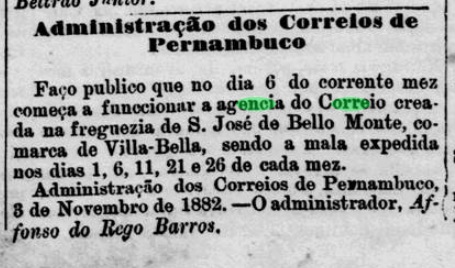
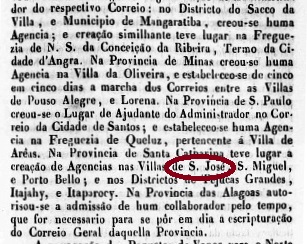
The local post office started operations in November 1882, according to the regional press:
Jornal de Recife, 5 November 1882
Until now, no postmark of the imperial period could be surely assigned to this locality.
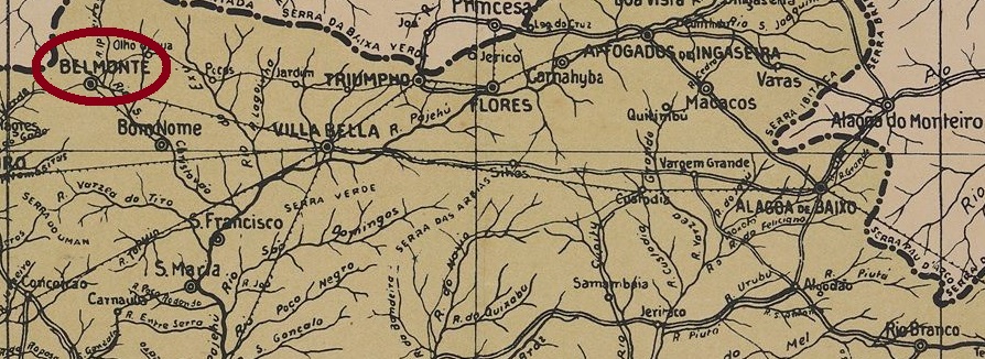
Arthur D. Ribeiro: Estado de Pernambuco, 1924
Andere Namen: Maniçoba, São José do Belmonte (1953)
São José do Bello Monte (= vom schönen Berg) war ab April 1873 ein Distrikt von Villa Bella (heute Serra Talhada), der ca. 470 km west der Provinzhauptstadt Recife lag. Im Juni 1893 stieg der Ort zur Villa im eigenen Município auf. Danach wechselte der Ortsname zweimal: 1943 zu Maniçoba (der Regionalname für die Maniokwurzel) und 1953 zum aktuellen São José do Belmonte.
Das örtliche Postamt startete den Betrieb im November 1882, wie aus der Regionalpresse zu entnehmen ist:
Jornal de Recife, 5. November 1882
Bisher konnte kein Poststempel der Kaiserzeit dieser Gemeinde mit Sicherheit zugeordnet werden.
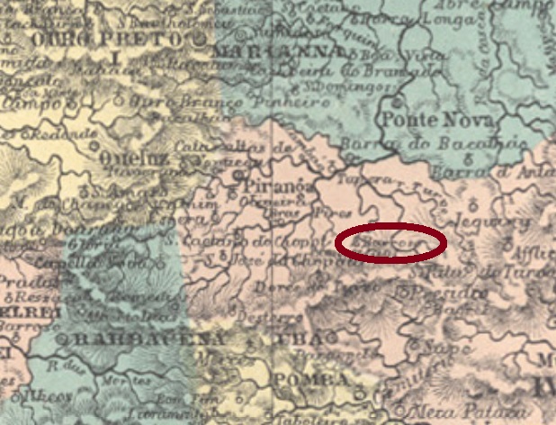
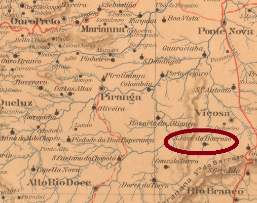
Since the 18th century, São José do Barroso was a settlement of Santa Rita do Turvo (today Viçosa, then a district of Mariana), which was located about 130 km southeast of the provincial capital Ouro Preto. Barroso was the first large landowner in the region to build a chapel in honour of St. Joseph. It became a district in 1854, in 1870 it changed to the municipality of Visconde do Rio Branco and in 1871 to Ubá. Since December 1953, it has been the municipality of Paula Cândido. He was, among others, a physician of the imperial family, politician and professor of medicine (1805-1864), who has earned great merit in the research on tropical diseases. He was born in the area, but was buried in the Montmartre Cemetery in Paris.
As Paula Sobrinho writes in his Historia Postal de Minas Gerais (Belo Horizonte, 1997), the post office in S. José do Barroso was established in October 1881. The only known imperial postmark is SMG-2445a (Coll. José A. Junges); a double circle with the inscription S. JOSÉ DO BARROSO above and an ornament in diamond form at the bottom, the four sides of which are open. The only known copy bears a date from 1886 in its centre.
Mappa de Minas Geraes, 1910
Anderer Name: Paula Cândido (1953)
São José do Barroso war seit dem 18. Jahrhundert eine Siedlung von Santa Rita do Turvo (heute Viçosa), damals bei Mariana, die ca. 130 km südöstlich der Provinzhauptstadt Ouro Preto entfernt lag. Barroso hieß der erste Großgrundbesitzer der Region, der eine Kapelle zu Ehren des Hl. Josephs errichten ließ. Der Ort wurde 1854 zum Distrikt, danach wechselte er 1870 zum Município von Visconde do Rio Branco und 1871 zu Ubá. Seit Dezember 1953 ist es der Município von Paula Cândido. Dieser war u.a. Arzt der kaiserlichen Familie, Politiker und Medizinprofessor (1805-1864), der große Verdienste in der Forschung über tropische Krankheiten erworben hat. Er wurde zwar in der Gegend geboren, liegt aber nun im Montmartre-Friedhof in Paris begraben.
Wie Paula Sobrinho in seiner Historia Postal de Minas Gerais (Belo Horizonte, 1997) schreibt, entstand das Postamt in S. José do Barroso im Oktober 1881. Der einzige bisher bekannte kaiserliche Poststempel ist SMG-2445a (Samml. José A. Junges); ein Doppelkreis mit der Inschrift S. JOSÉ DO BARROSO oben und einem Ornament als Raute unten, dessen vier Seiten offen sind. Das einzige Exemplar trägt in seiner Mitte ein Datum aus 1886.
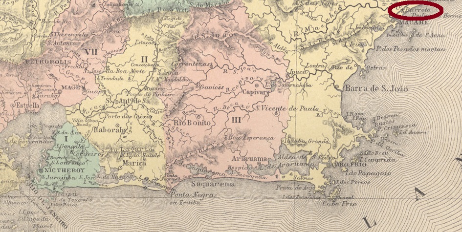
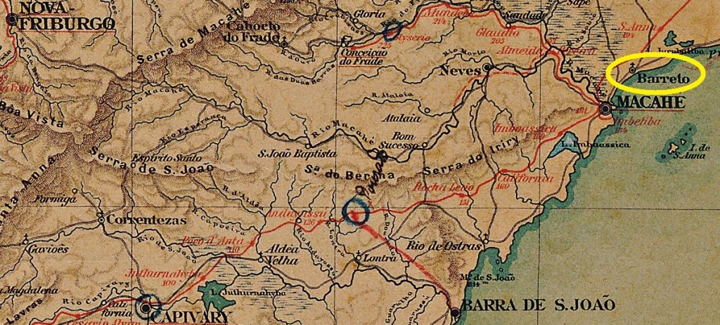
Other names: Barreto, Cabiúnas (1938), Barra de Macaé (1969)
São José do Barreto was a small settlement near Macahe (now written Macaé), located directly on the Atlantic Ocean, 200 km west of the imperial capital Rio de Janeiro. In October 1857 it became a district, later a freguesia, which has since changed its name twice: to Cabiúnas (1938) and to Barra de Macaé (1969).
As Paulo Novaes reports in agenciaspostais.com.br, there was an imperial post office there between 1870 and “ca. 1886”. However, the agency may have opened earlier, as two local postal clerks were mentioned before 1870:
Almanak Laemmert, 1865Almanak Laemmert, 1869
A postmark in the Empire was found: SRJ-1430a (Coll. José A. Junges) shows an ellipse with the inscription S. JÉ. DO BARRETO, found on stamps issued in 1866 and 1877.
Almanak Laemmert, 1892
Andere Namen: Barreto, Cabiúnas (1938), Barra de Macaé (1969)
São José do Barreto war eine kleine Siedlung bei Macahe (heute Macaé geschrieben), die direkt am Atlantik, 200 km westlich der kaiserlichen Hauptstadt Rio de Janeiro entfernt lag. Im Oktober 1857 wurde daraus ein Distrikt – später auch eine Freguesia – der seitdem den Namen zweimal gewechselt hat: zu Cabiúmas (1938) und zu Barra de Macaé (1969).
Wie Paulo Novaes in agenciaspostais.com.br berichtet, gab es dort ein kaiserliches Postamt zwischen 1870 und „ca. 1886“. Die Agentur könnte dennoch früher mal geöffnet haben, denn zwei Postangestellte vor Ort wurden vor 1870 bekannt gemacht:
Almanak Laemmert 1865Almanak Laemmert 1869
Ein Poststempel im Kaiserreich wurde gefunden: SRJ-1430a (Samml. José A. Junges) zeigt eine Ellipse mit der Inschrift S. JÉ. DO BARRETO, gefunden auf Marken, die 1866 und 1877 ausgegeben wurden.
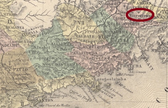
Sao José do Barreiro (also spelled dos Barreiros) was a freguesia in the municipality of Areias, located at the foothills of the Serra da Bocaína, more than 260 km northeast of the provincial capital São Paulo. The village rose to a villa in March 1859 and to a town in March 1885. Between 1938 and 1953, the municipality was simply called Barreiro, then the old, full name returned.
According to Nova Monteiro (Administrações e Agencias Postaes do Brasil Imperio, in Brasil Filatelico/RJ, 1934-5; Reprint SPP 1994-1999) the local post office was established in December 1834. The first two cancels of the agency bore the name BARREIRO and were depicted by R. Koester (Carimbologia III). SSP-1585a (Coll. José A. Junges) is the first full name cancel, bringing the inscription S. J. DO BARREIRO above between two circles. The dates at the centre originate from the period 1879-1888.
Villiers de l’Ile Adam: Carta (…) da Provincia de São Paulo, 1847
Siehe auch Barreiro (R. Koester: Carimbologia III)
São José do Barreiro (auch dos Barreiros geschrieben) war ab März 1842 eine Freguesia im Município von Areias, die am Ausläufer der Serra da Bocaína, über 260 km nordöstlich der Provinzhauptstadt São Paulo entfernt lag. Der Ort stieg im März 1859 zur Villa und im März 1885 zur Stadt auf. Zwischen 1938 und 1953 hieß der Município einfach Barreiro, dann kehrte der alte, vollständige Name zurück.
Laut Nova Monteiro (Administrações e Agencias Postaes do Brasil Imperio, in Brasil Filatelico/RJ, 1934-5; Reprint SPP 1994-1999) entstand das örtliche Postamt bereits im Dezember 1834. Die ersten zwei Stempel der Agentur trugen die Bezeichnung BARREIRO und sind bei R. Koester (Carimbologia III) abgebildet. Als erster – und wohl einziger – Poststempel des Kaiserreichs mit vollem Ortsnamen trägt SSP-1585a (Samml. José A. Junges) die Inschrift S. J. DO BARREIRO oben zwischen zwei Kreisen. Die Daten in der Mitte entstammen dem Zeitraum 1879-1888.
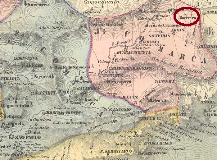
Villiers de l’Ile Adam: Carta (…) da Provincia de Minas Geraes, 1849
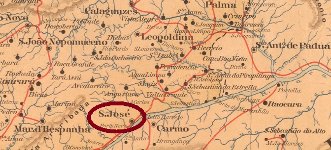
Another name: Além Parahyba (1923)
From July 1832, this was a district of Mar d’Hespanha, located directly on the north bank of the Parahyba River, and thus directly on the provincial border with Rio de Janeiro, about 300 km south of the provincial capital Ouro Preto. In November 1880, the locality became a villa and in September 1883, a city, which since September 1923 has been called just Além Parahyba (now written Paraíba).
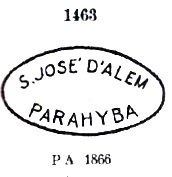
Nova Monteiro (Administrações e Agencias Postaes do Brasil Imperio, in Brasil Filatelico/RJ, 1934-5; Reprint SPP 1994-1999) and Paula Sobrinho (História Postal de Minas Gerais, Belo Horizonte, 1997) agree that there has been a post office there since February 1864. They do not agree on the exact day, but we will be not concerned about that. Four postmarks in the imperial era are handed down, a sure sign of intense postal activity. SMG-2420a is the first of these; it was in circulation until at least 1877, having been already introduced by Paulo Ayres at No. 1463:
SMG-2420a (P.A. 1463)
It was followed by three cancels with double circles, all of which also appear in blue or blue green. SMG-2420b (Coll. José A. Junges), has the inscription S. J. D’ALÉM PARAHYBA above. The dates at the centre are from about 1877 to 1887. At SMG-2420c (Coll. José A. Junges) is the inscription on top S. JOSÉ D’ALEM PARAHYBA, and below there is now a cross as an ornament, which is formed from four converging arrowheads. His dates are from about 1883 to 1885, although the year may be missing. The last cancel SMG-2420d (Coll. Karlheinz Wittig) has the inscription S. JE. D’ALEM=PARAHYBA above and an ornament in X-form below. Dates: ca. 1884 to 1895.
Mappa de Minas Geraes, 1910
Anderer Name: Além Parahyba (1923)
São José d’Além Parahyba war ab Juli 1832 ein Distrikt von Mar d’Hespanha, der direkt am Nordufer des Flusses Parahyba und dadurch auch direkt an der Provinzgrenze zu Rio de Janeiro lag, ca. 300 km südlich der Provinzhauptstadt Ouro Preto entfernt. Im November 1880 stieg der Ort zu einer Villa und im September 1883 zu einer Stadt auf, die seit September 1923 nur Além Parahyba (heute Paraíba geschrieben) heißt.
Nova Monteiro (Administrações e Agencias Postaes do Brasil Imperio, in Brasil Filatelico/RJ, 1934-5; Reprint SPP 1994-1999) und Paula Sobrinho (História Postal de Minas Gerais, Belo Horizonte, 1997) sind sich darüber einig, dass es dort seit Februar 1864 ein Postamt gibt. Wobei sie sich nicht einig über den genauen Tag sind, aber das sollte uns nicht weiter beschäftigen. Vier Poststempel in der Kaiserzeit sind überliefert, ein sicheres Zeichen für rege postalische Aktivität. SMG-2420a ist der erste davon, der bis mindestens 1877 im Umlauf blieb und bereits durch Paulo Ayres unter Nr. 1463 vorgestellt wurde:
SMG-2420a (P.A. 1463)
Ihm folgten drei Stempel mit Doppelkreisen, die alle auch in blau oder blaugrün vorkommen. SMG-2420b (Samml. José A. Junges), hat die Inschrift S. J. D’ALÉM PARAHYBA oben. Die Daten in der Mitte gehen von ca. 1877 bis 1887. Bei SMG-2420c (Samml. José A. Junges) lautet die obige Inschrift S. JOSÉ D’ALEM PARAHYBA, und unten gibt es nun als Ornament ein Kreuz, das aus vier konvergierenden Pfeilspitzen gebildet wird. Seine Daten gehen von ca. 1883 bis 1885, wobei die Jahresangabe auch mal fehlen kann. Der letzte Stempel SMG-2420d (Samml. Karlheinz Wittig) hat die Inschrift S. JE. D’ALEM=PARAHYBA oben und ein Ornament in X-Form unten. Daten: ca. 1884 bis 1895.
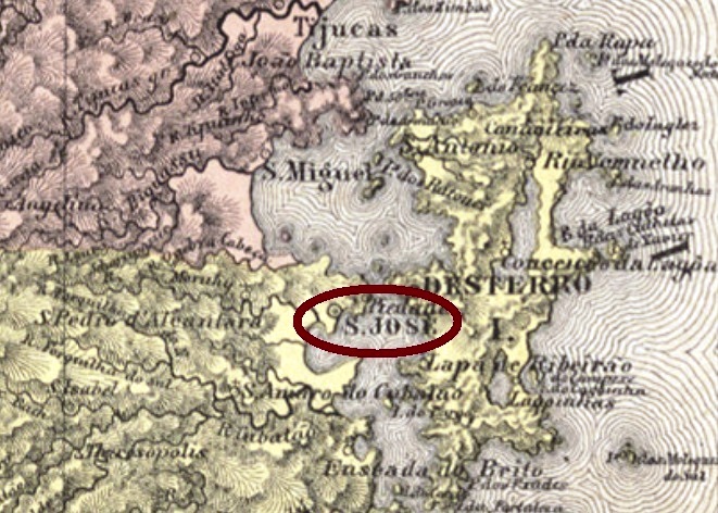
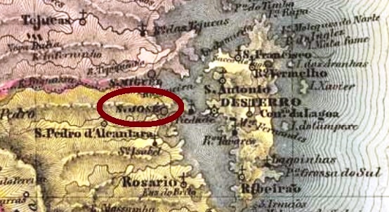
The old and proud freguesia of São José, founded in October 1751, has now become a suburb of Florianópolis, for it is located just 15 km west of the former provincial capital Desterro. The Hercilio-Luz Bridge over the waterway made it possible in 1926. Before that, however, São José became a villa (March 1833) and also a town (May 1856).
The Imperial Mail Register (Tabella das Agencias do Correio do Imperio) of 1885 reports a post office there since 1875. However, new research has shown that as early as 1840 a post office was in operation on site, as can be seen from a ministerial report of May 1841:
Relatorio do Ministerio do Imperio 1840, May 1841
However, this post office must have been closed between 1850 (last press mention, so far) and 1856, for it was no longer listed in the Postal Guide (Guia do Correio do Brasil) for 1857. The only postmark of the imperial period clearly dates from the second period of operation, because it presents dates between 1882 and 1890 at the centre. SSC-0225b (Coll. José A. Junges) shows a double circle with the inscription S. JOSÉ at the top and an ornament in diamond form at the bottom, which consists of four small diamonds.
Villiers de l’Ile Adam: Carta (…) da Provincia de Santa Catharina, 1848
Die alte und stolze Freguesia von São José – gegründet im Oktober 1751 – ist heute ein Vorort von Florianópolis geworden, denn sie liegt nur 15 km westlich der ehemaligen Provinzhauptstadt Desterro. Die Hercilio-Luz-Brücke über die Wasserstraße machte es 1926 möglich. Vorher aber wurde aus São José eine Villa (März 1833) und auch eine Stadt (Mai 1856).
Dieses Postamt muss aber zwischen 1850 (bisher letzte Presseerwähnung) und 1856 geschlossen worden sein, da es nicht mehr im Postführer (Guia do Correio do Brasil) für 1857 aufgelistet wurde. Der einzige Poststempel der Kaiserzeit stammt eindeutig aus der zweiten Betriebsperiode, denn er trägt Daten von 1882 bis 1890 in der Mitte. SSC-0225b (Samml. José A. Junges) zeigt einen Doppelkreis mit der Inschrift S. JOSÉ oben und einem Ornament in Rautenform unten, das aus vier kleinen Rauten besteht.
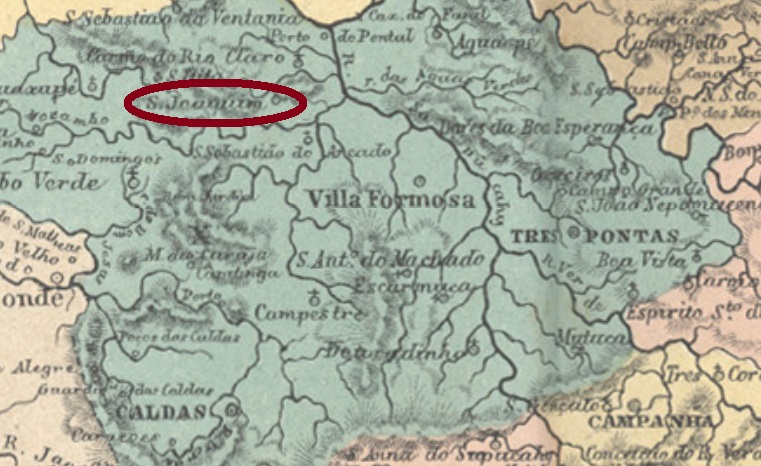
From June 1850, São Joaquim da Serra Negra was a district of Caldas, located more than 430 km southwest of the provincial capital Ouro Preto. Serra Negra means Black Mountains, but on old maps the mountain ranges around S. Joaquim were called Serra da Ventania and Serra dos Lemos. Anyway, in October 1860 the district moved to the newly founded Municipality of Alfenas and in September 1923 was given the simplified name Serra Negra. After the political emancipation as Municipio in December 1938, the name changed again five years later to the current Alterosa. This name is a popular term for highlands in Minas Gerais.
Paula Sobrinho writes in his História Postal de Minas Gerais (Belo Horizonte, 1997) that there has been a post office there since September 1881. Two early cancels were found. SMG-2415a (Coll. José A. Junges) has a double circle with the inscription S. JOAQUIM DA SERRA NEGRA above and an ornament in diamond form below, which consists of four small diamonds. Dated in the middle between 1887 and at least 1890. The successor SMG-2415b (Coll. Márcio Protzner) may be already republican, for the only known copy is already dated 1903. In the double circle one now reads S. JM. DA SERRA NEGRA above and (MINAS) below, with date inside.
Minas Geraes, 1910
Andere Namen: Serra Negra, Alterosa (1943)
São Joaquim da Serra Negra war ab Juni 1850 ein Distrikt bei Caldas, der über 430 km südwestlich der Provinzhauptstadt Ouro Preto entfernt lag. Serra Negra bedeutet Schwarzes Gebirge, aber auf alten Karten heißen die Bergketten um S. Joaquim Serra da Ventania und Serra dos Lemos. Wie es dem auch sei, im Oktober 1860 wechselte der Distrikt zum neu gegründeten Município von Alfenas und bekam im September 1923 den vereinfachten Namen Serra Negra. Nach der politischen Emanzipation als Município im Dezember 1938 wechselte nochmals der Name fünf Jahre später zum aktuellen Alterosa. Der Name ist ein in Minas Gerais beliebter Begriff für Hochland.
Paula Sobrinho schreibt in seiner Historia Postal de Minas Gerais (Belo Horizonte, 1997), dass es dort ein Postamt seit September 1881 gibt. Zwei frühe Stempel waren zu finden. SMG-2415a (Samml. José A. Junges) hat einen Doppelkreis mit der Inschrift S. JOAQUIM DA SERRA NEGRA oben und einem Ornament in Rautenform unten, das aus vier kleinen Rauten besteht. Datiert in der Mitte zwischen 1887 und zumindest 1890. Der Nachfolger SMG-2415b (Samml. Márcio Protzner) dürfte bereits republikanisch sein, denn das Datum des bisher einzig gesichteten Exemplars zeigt bereits 1903. Im Doppelkreist liest man nun S. JM. DA SERRA NEGRA oben und (MINAS) unten, mit Datum im Inneren.
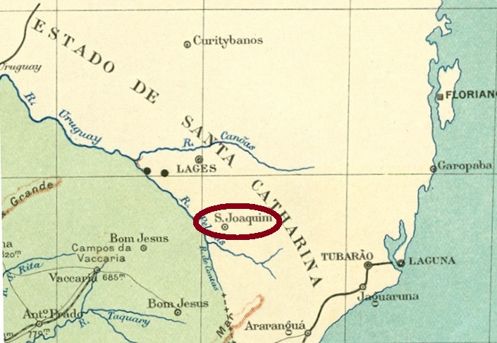
The town of São Joaquim, now known nationwide for its apples, its wines and its cold climate, is located more than 1350 m high on the mountain slope (Costa da Serra) of the former province of Santa Catarina, about 230 km southwest of the state capital Florianópolis, which was then the provincial capital Desterro. In May 1871 it was elevated to a district of Lages and received the political-administrative emancipation as a villa in August 1886. Since October 1924, São Joaquim has been a town.
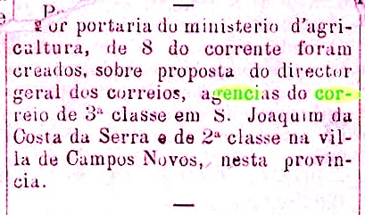
There is a post office there since February 1882, as reported by the provincial press:
Jornal do Commercio/SC, 15.02.1882
An imperial postmark is also known: SSC-0220a (Coll. José A. Junges) consists of a double circle, bearing above the inscription S. JOAQM. DA COSTA DA SERRA. There is an ornament in diamond form below, the four sides of which are open. The dates at the centre were found so far within the period 1884-1890.
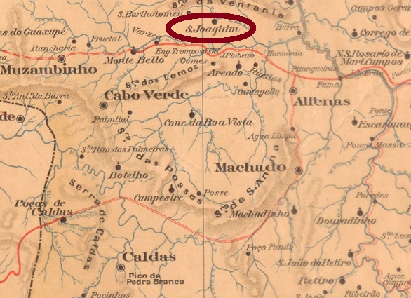
Briguiet: Mappa do Rio Grande do Sul, 1923
Andere Namen: Costa da Serra, São Joaquim
Die heute durch ihre Äpfel, ihre Weine und ihre Kälte landesweit bekannte Stadt São Joaquim liegt über 1350 m hoch am Gebirgshang (Costa da Serra) der ehemaligen Provinz Santa Catarina, gut 230 km südwestlich der Landeshauptstadt Florianópolis, die damals als Provinzhauptstadt Desterro hieß. Im Mai 1871 wurde sie zum Distrikt von Lages erhoben und erhielt die politisch-administrative Emanzipation als Villa im August 1886. Seit Oktober 1924 darf sich São Joaquim eine Stadt nennen.
Der imperiale Poststempel ist auch bekannt: SSC-0220a (Samml. José A. Junges) besteht aus einem Doppelkreis, der oben die Inschrift S. JOAQM. DA COSTA DA SERRA trägt. Unten sieht man ein Ornament in Rautenform, dessen vier Seiten offen sind. Die Daten in der Mitte wurden bisher innerhalb des Zeitraums 1884-1890 gefunden.
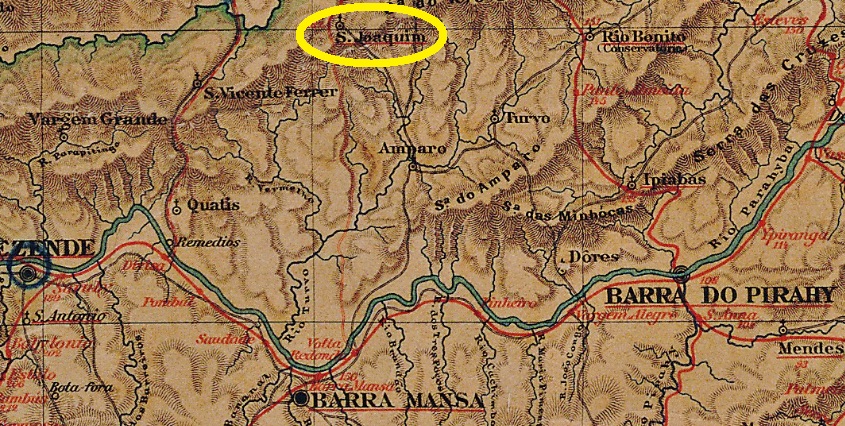
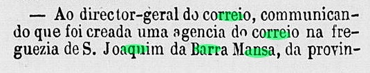
São Joaquim was from October 1851 a district in the municipality of Barra Mansa, located about 170 km northwest of the imperial capital Rio de Janeiro. In December 1943, it changed the name to Ribeirão de S. Joaquim, who has belonged to the Quatis municipality since January 1991.
As Paulo Novaes writes in agenciaspostais.com.br, there has been a post office there since March 1860. This is confirmed by ministerial protocol:
Expediente do Ministerio do Imperio, 30 March 1860
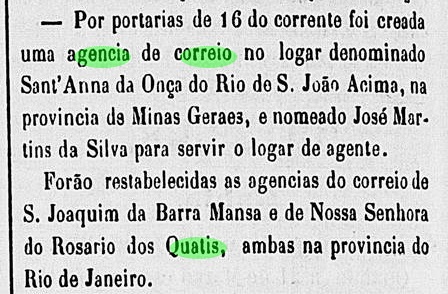
However, the agency closed in July 1861 and did not reopen until April 1864:
Constitucional, 19 April 1864
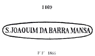
The following postmarks of the imperial period have been handed down. SRJ-1415a was in use until at least 1866, having been already presented by Paulo Ayres in Catalogo de Carimbos Brasil-Império, (S. Paulo, 1937, 1942) under No. 1469:
SRJ-1415a (P. Ayres 1469)
It was followed by SRJ-1415b (image from the internet): a double circle with the inscription S. JOAQM. DA BARA. MANSA above and a diamond-shaped ornament at the bottom, the four sides of which are open. Dates in the centre: 1885-1898.
A new cancel from this locality appeared after the publication of Carimbologia S2. SRJ-1415c (Coll. Fuad Ferreira Fo.) is probably earlier than SRJ-1415b and was seen on a fragment of 1880, also showing a mute cancel on a bisected stamp:
São Joaquim war ab Oktober 1851 ein Distrikt im Município von Barra Mansa, der ca. 170 km nordwestlich der kaiserlichen Hauptstadt Rio de Janeiro lag. Im Dezember 1943 wechselte sein Name zu Ribeirão de S. Joaquim, der seit Januar 1991 dem Município von Quatis angehört.
Wie Paulo Novaes in agenciaspostais.com.br schreibt, gibt es dort ein Postamt seit März 1860. Das wird durch Ministerialprotokoll bestätigt:
Expediente do Ministerio do Imperio, 30. März 1860
Die Agentur schloss allerdings im Juli 1861 und eröffnete erst im April 1864 wieder:
Ihm folgte SRJ-1415b (Abb. aus dem Internet): ein Doppelkreis mit der Inschrift S. JOAQM. DA BARA. MANSA oben und einem Ornament in Rautenform unten, dessen vier Seiten offen sind. Bisherige Daten in der Mitte: 1885-1898.
Nach der Veröffentlichung von Carimbologia S2 erschien ein bisher unbekannter Stempel dieses Ortes. SRJ-1415c (Samml. Fuad Ferreira Fo.) ist wahrscheinlich älter als SRJ-1415b und wurde auf einem Fragment von 1880 gesehen, das ebenfalls einen stummen Stempel auf einer Markenhalbierung zeigt:
SRJ-1415c (Samml. Fuad Ferreira Fo.) und stummer Stempel (1880)
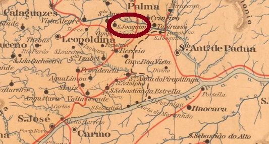
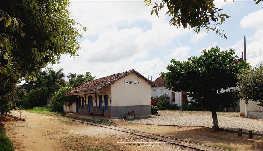
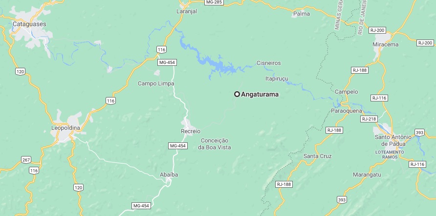
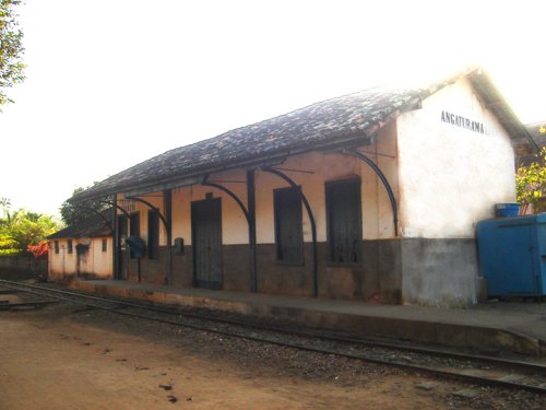
The train station of S. Joaquim was inaugurated in April 1883 by the E.F. Leopoldina Railway Company, Manhuassu Line, located in the Leopoldina Municipality, about 270 km southeast of the provincial capital Ouro Preto. In 1975, the railway line went to Ferroviaria Federal S.A., and so it remained until the end of operation in 1996. Today, the station building serves as a medical centre (estacoesferroviarias.com.br).
The settlement around the station continued to grow and was elevated to a district in November 1890. In December 1938, the district became the new municipality of Recreio, and five years later it was given the current name Angaturama. The word comes from the Tupi-guarani language and means generous soul.
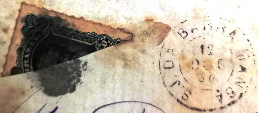
According to Paula Sobrinho (Historia Postal de Minas Gerais, Belo Horizonte, 1997), there was a S. Joaquim station post office from July 1883. The imperial postmark of this is SMG-2410a (Coll. Karlheinz Wittig): a double circle with the inscriptions S. JOAQUIM above and (ESTAÇĀO) below. The dates at the centre are from the period 1885-1893ff.
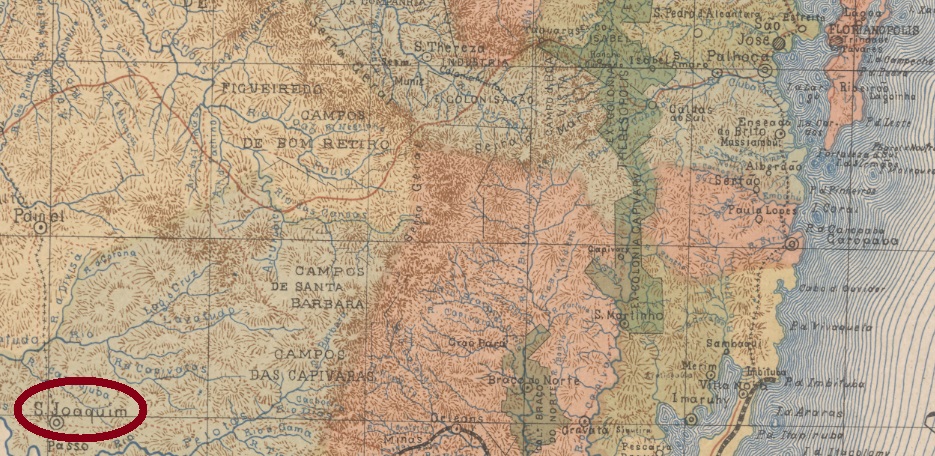
Google Maps
Anderer Name: Angaturama (1943)
Der Bahnhof São Joaquim wurde im April 1883 durch die E.F. Leopoldina Bahngesellschaft, Manhuassu-Linie, eingeweiht und lag im Município de Leopoldina, ca. 270 km südöstlich der Provinzhauptstadt Ouro Preto entfernt. 1975 ging die Bahnlinie zur Rede Ferroviaria Federal S.A., und dabei blieb es bis Betriebsende in 1996. Heute dient das Bahnhofsgebäude als Medizinambulanz (estacoesferroviarias.com.br).
Die Siedlung um den Bahnhof wuchs weiter und wurde im November 1890 zum Distrikt erhoben. Im Dezember 1938 ging der Distrikt zum neuen Município von Recreio über und fünf Jahre später bekam er den heute noch aktuellen Namen Angaturama. Das Wort kommt aus der Tupi-guarani-Sprache und bedeutet Gütige Seele.
Laut Paula Sobrinho (Historia Postal de Minas Gerais, Belo Horizonte, 1997) gab es ein S. Joaquim-Bahnhofspostamt ab Juli 1883. Der kaiserliche Poststempel davon ist SMG-2410a (Samml. Karlheinz Wittig): ein Doppelkreis mit den Inschriften S. JOAQUIM oben und (ESTAÇĀO) unten. Die Daten in der Mitte entstammen dem Zeitraum 1885-1893ff.