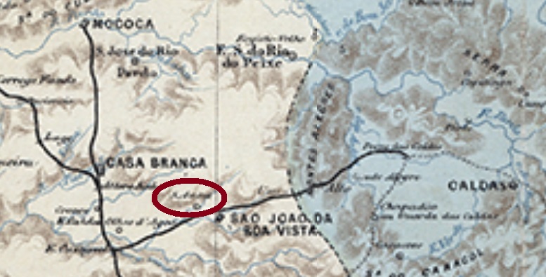
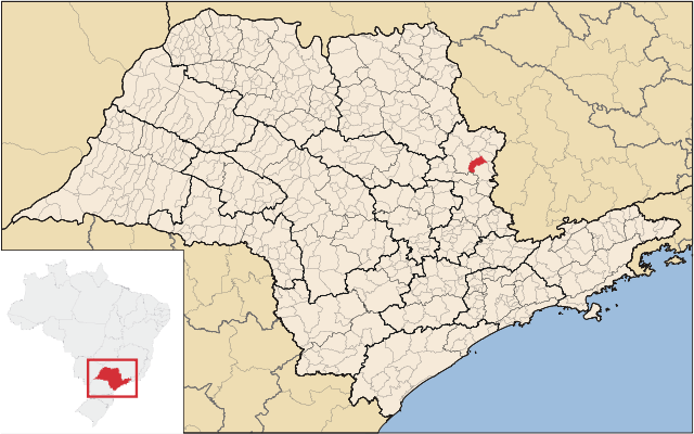
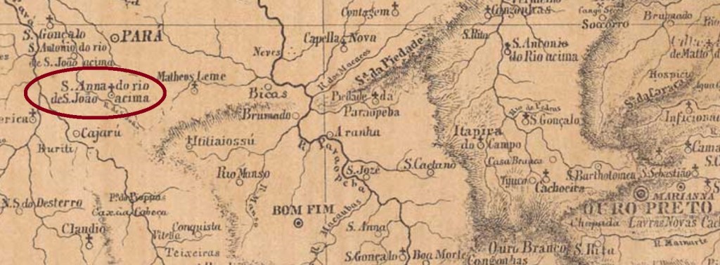
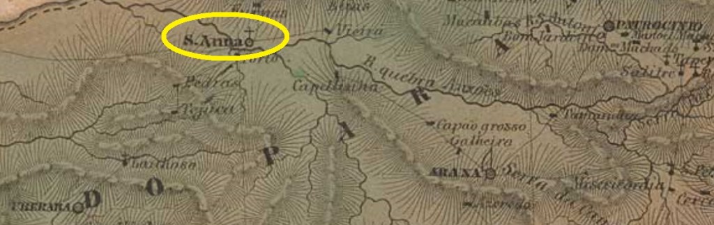
Sant’Anna da Vargem Grande was from February 1888 on a district in the municipality of São João da Boa Vista, situated round 250 km north of the provincial capital São Paulo. In December 1921 it was elevated to an own municipality, which since November 1944 is called Vargem Grande do Sul.
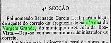
According to the regional press, the local post office was created around the end of 1886:
Correio Paulistano, January 9, 1887
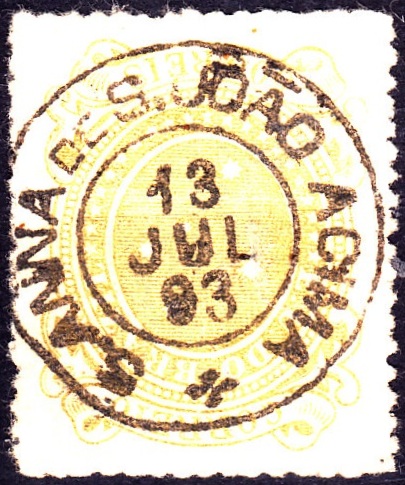
One early cancel was found: SSP-1263a (Coll. José Junges) has a double circle with the inscription S. ANNA DA V. GRANDE above and a black circle ornament below, which is cut by a cross inside. It was used at least until 1897.
Raphael Lorenzeto de Abreu, CC- BY 2.5
Anderer Name: Vargem Grande do Sul (1944)
Sant’Anna da Vargem Grande war ab Februar 1888 ein Distrikt im Município von São João da Boa Vista, der rund 250 km nördlich der Provinzhauptstadt São Paulo entfernt lag. Im Dezember 1921 stieg er zum eigenen Município auf, der seit November 1944 Vargem Grande do Sul heißt.
Laut einer Meldung aus der Regionalpresse wird das örtliche Postamt wohl gegen Ende 1886 entstanden sein:
Correio Paulistano, 9. Januar 9, 1887
Ein früher Stempel war noch zu finden: SSP-1263a (Samml. José Junges) hat einen Doppelkreis mit der Inschrift S. ANNA DA V. GRANDE oben und einen schwarzen Kreis unten, der in der Mitte kreuzförmig beschnitten wird. Die Daten in der Mitte weisen auf einen Nutzungszeitraum bis mindestens 1897 auf.
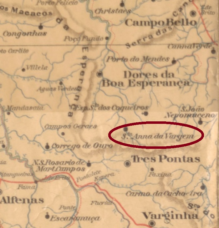
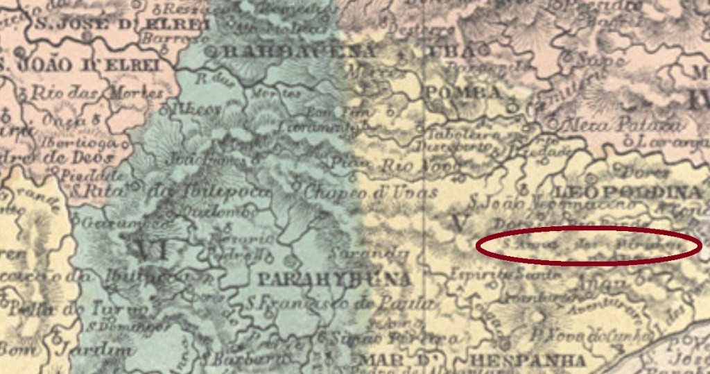
The following Sant’Anna of the Minas Gerais province was since November 1873 a district in the municipality of Três Pontas, situated over 300 km southwest of the province capital Ouro Preto. In September 1923 the name changed to Mombuca, a tupi-guarani word that designates a kind of honey bee, but exactly one year later the old toponym returned. Since December 1962 has Santana da Vargem an own municipality.
According to Paula Sobrinho (História Postal de Minas Gerais, Belo Horizonte, 1997), there is a local post office since June 1879. The only early cancel found until now is SMG-2700a (image from the internet): a double circle with the inscription SANT’ANNA DA VARGEM above and a cross ornament below, of which every wing is a leaflet. The dates at the centre were found for the period 1895-1899.
Raphael Lorenzeto de Abreu (CC-BY 2.5)
Andere Namen: Sant’Anna da Vargem Grande, Mombuca
Die nächste Sant’Anna in der Provinz Minas Gerais war ab November 1873 ein Distrikt im Município von Três Pontas, der über 300 km südestlich der Provinzhauptstadt Ouro Preto entfernt lag. Im September 1923 wechselte der Ortsname zu Mombuca. Dieses Wort der Tupi-guarani-Sprache nennt eine Sorte Honigbiene. Dennoch kehrte gleich ein Jahr später der alte Name zurück. Seit Dezember 1962 hat Santana da Vargem ein eigenes Município.
Wie Paula Sobrinho in seiner História Postal de Minas Gerais (Belo Horizonte, 1997) schreibt, gibt es dort ein Postamt seit Juni 1879. Der einzige frühe Stempel, der bisher aufgetaucht ist, SMG-2700a (Abb. aus dem Internet), hat einen Doppelkreis mit der Inschrift SANT’ANNA DA VARGEM oben und ein kreuzförmiges Ornament unten, bei dem alle Flügel aus Blättchen bestehen. Die Daten in der Mitte kommen aus dem Zeitraum 1895-1899.
Other names: Senhor Bom Jesus do Ribeirão de Sant’Anna, Salto, Pirangaí (1943)
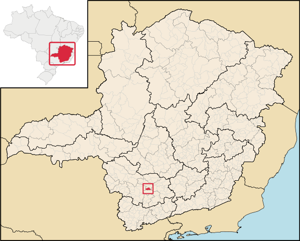
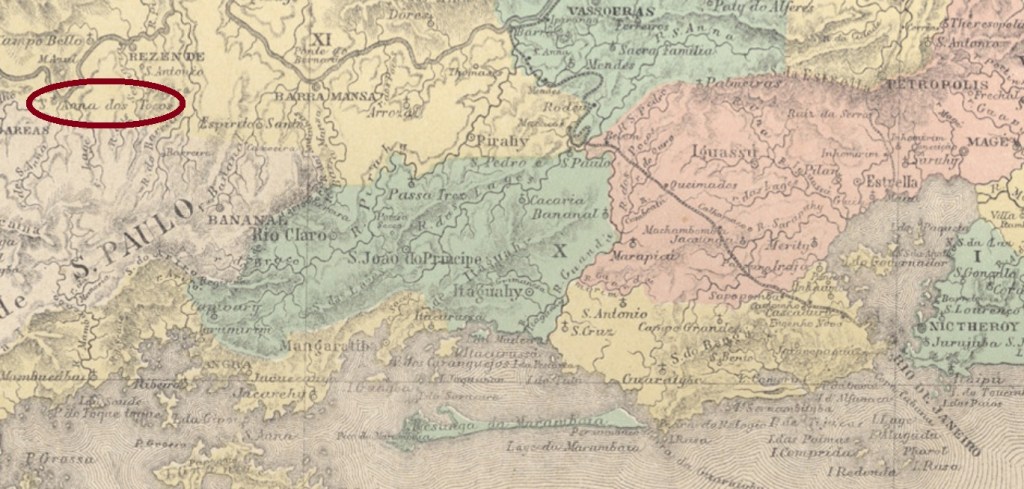
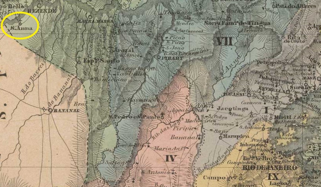
Sant’Anna dos Tocos was since 1830 a curato named Senhor Bom Jesus do Ribeirão de Sant’Anna in the municipality of Resende, situated on the Paraiba do Sul River, over 200 km west of the imperial capital Rio de Janeiro. In March 1843 it was made the district of Sant’Anna dos Tocos, which has since then changed twice the name: in December 1938 to Salto and in December 1943 to Pirangaí. This tupi-guarani word means red clay river.
The village disappeared in 1961, when it was inundated by the Represa do Funil Barrier Lake, and was rebuilt in the place which now is the Pirangaí quarter of the municipality of Resende. Images of the old Sant’Anna dos Tocos can be seen here:
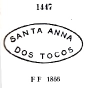
It was followed by SRJ-2170b (Coll. Karlheinz Wittig): a double circle with the inscription SANT’ANNA DOS TOCOS above and a diamond ornament below. The dates at the centre were found for the period 1887-1890. Far more common is SRJ-2170c (image from the internet), which circulated from 1888 to 1903 and presented in the double circle the inscription S. ANNA DOS TOCOS above and a horizontal hashtag ornament below.
Villiers de l’Ile Adam: Carta (…) da Provincia do Rio de Janeiro. 1850
Andere Namen: Senhor Bom Jesus do Ribeirão de Sant’Anna, Salto, Pirangaí (1943)
Sant’Anna dos Tocos war ab 1830 ein Curato aus dem Município von Resende, der Senhor Bom Jesus do Ribeirão de Sant’Anna hieß und am Fluss Paraiba do Sul lag, über 200 km westlich der kaiserlichen Hauptstadt Rio de Janeiro entfernt lag. Im März 1843 wurde daraus der Distrikt von Sant’Anna dos Tocos, der seitdem den Namen zwimal gewechselt hat: im Dezember 1938 zu Salto und im Dezember 1943 zu Pirangaí. Dieses Wort aus der tupi-guarani-Sprache bedeutet Roter-Lehm-Fluss.
Die ursprüngliche Ortschaft wurde 1961 überschwemmt, als der Represa do Funil-Staudamm gebaut wurde, und musste woanders wieder angesiedelt werden. Heute ist Pirangaí ein Stadtteil von Resende. Bilder aus der frühen Sant’Anna dos Tocos sind hier zu sehen:
Laut Nova Monteiro (Administrações e Agencias Postaes do Brasil Imperio, in Brasil Filatelico/RJ, 1934-5; Reprint SPP 1994-1999) entstand das örtliche Postamt im Mai 1868. Drei Stempel der Kaiserzeit sind bekannt. Der früheste darunter, SRJ-2170a, wurde bereits durch Paulo Ayres in seinem Catálogo de Carimbos Brasil-Império, S. Paulo, 1937, 1942, unter Nr. 1447 veröffentlicht:
SRJ-2170a, P. Ayres 1447, 1868ff
Ihm folgte SRJ-2170b (Samml. Karlheinz Wittig): ein Doppelkreis mit der Inschrift SANT’ANNA DOS TOCOS oben und einem rautenförmigen Ornament unten. Die Daten in der Mitte weisen auf den Zeitraum 1887-1890 auf. Viel häufiger anzutreffen ist SRJ-2170c (Abb. aus dem Internet), der zwischen 1888 und 1903 im Gebrauch war. Er zeigt im Doppelkreis oben die Inschrift S. ANNA DOS TOCOS und unten ein Hashtag-ähnliches Ornament.
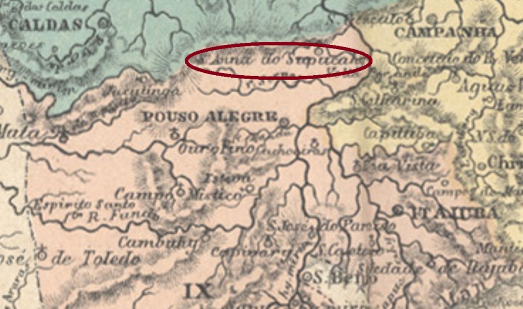
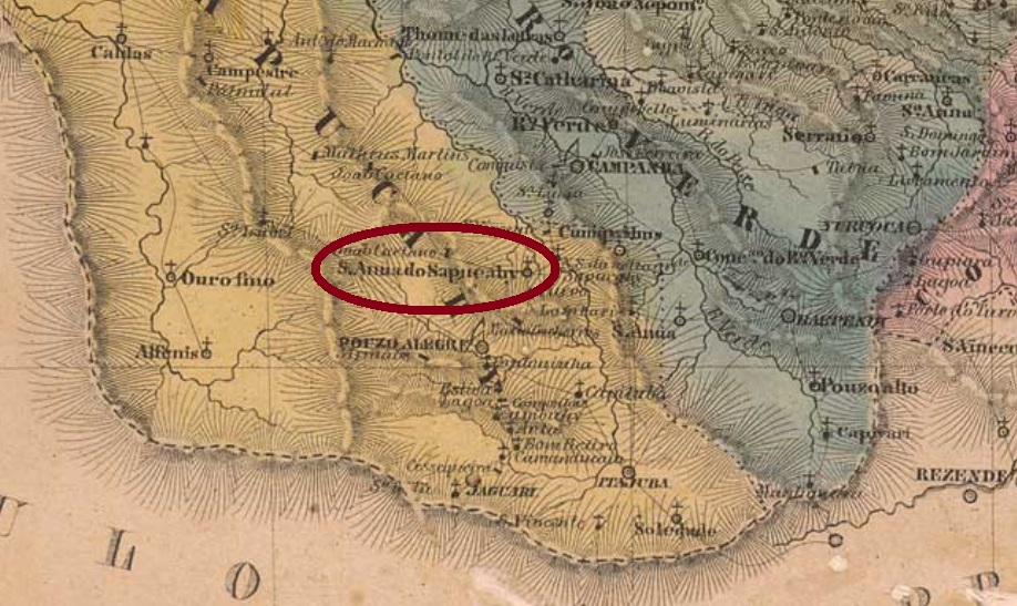
Another Sant’Anna in the Minas Gerais province! This one was since April 1838 a district in the municipality of Pouso Alegre, situated over 400 km southwest of the province capital Ouro Preto. In August 1911 it emancipated under the name of Silvianópolis, a tribute to Francisco Silviano Brandão (1848-1902), a native of Sant’Anna do Sapucahy who was the president of the Minas Gerais state between 1898 and 1902.
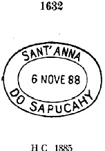
According to Paula Sobrinho (História Postal de Minas Gerais, Belo Horizonte, 1997), the local post office was created in October 1873. One postmark from the Empire was found. SMG-2730a occurs also in red with dates between 1883 and at least 1900, and was already presented by Paulo Ayres in his Catálogo de Carimbos Brasil-Império, S. Paulo, 1937, 1942 under # 1632:
SMG-2730a (P. Ayres #1632)Villiers de l’Ile Adam: Carta (…) da Provincia de Minas Geraes, 1849
Und schon wieder eine Sant’Anna aus der Provinz Minas Gerais! Diese war ab April 1838 ein Distrikt im Município von Pouso Alegre und lag über 400 km südwestlich der Provinzhauptstadt Ouro Preto entfernt. Im August 1911 stieg sie zum eigenen Município auf und hieß fortan Silvianópolis. Der Name ist eine Hommage an Francisco Silviano Brandão (1848-1902), einen Sohn der Ortschaft, der zwischen 1898 und 1902 Präsident des Staates Minas Gerais war.
Laut Paula Sobrinho (História Postal de Minas Gerais, Belo Horizonte, 1997) gibt es dort ein Postamt seit Oktober 1873. Ein Stempel aus dem Kaiserreich konnte gefunden werden. SMG-2730a kommt mit Daten zwischen 1883 und zumindest 1900 – auch in rot – vor und wurde bereits durch Paulo Ayres in seinem Catálogo de Carimbos Brasil-Império, S. Paulo, 1937, 1942 under # 1632 vorgestellt:
The somewhat enigmatic name of this locality means Sant’Anna on the Upper Course of the São João River. This was since April 1841 a district in the municipality of Bomfim, situated over 160 km west from the provincial capital Ouro Preto. In September 1901 it emancipated as the Villa de Itaúna – a tupi-guarani word that means black stone – which was elevated to a town fourteen years later.
According to Paula Sobrinho (História Postal de Minas Gerais, Belo Horizonte, 1997), the local post office was created in February 1877. One imperial cancel has been found: SMG-2715a shows dates between 1885 and 1898 and was already presented by Paulo Ayres in his Catálogo de Carimbos Brasil-Império, S. Paulo, 1937, 1942, on page 125:
SMG-2715a (Apud P. Ayres)
However, this image is not quite clear, because the ornament below is actually formed by four small diamonds, as shown through this image from the Karlheinz Wittig collection:
SMG-2715a recte (Coll. K. Wittig)Provincia de Minas Geraes, 1873
Anderer Name: Itaúna (1902)
Der etwas rätselhalte Name dieser Ortschaft bedeutet eigentlich Sant’Anna am Oberlauf des Flusses São João. Sie war ab 1841 ein Distrikt im Município von Bomfim, der über 160 km westlich der Provinzhauptstadt Ouro Preto entfernt lag. Im September 1901 erhielt der Ort den Status einer Villa, die Itaúna hieß – ein Wort der tupi-guarani-Sprache, das Schwarzer Stein bedeutet. Vierzehn Jahre später stieg Itaúna zur Stadt auf.
Laut Paula Sobrinho (História Postal de Minas Gerais, Belo Horizonte, 1997) entstand das örtliche Postamt im Februar 1877. Ein Stempel der Kaiserzeit wurde gefunden: SMG-2715a zeigt Daten zwischen 1885 und 1898 und wurde bereits durch Paulo Ayres in seinem Catálogo de Carimbos Brasil-Império, S. Paulo, 1937, 1942, auf S. 125 vorgestellt:
SMG-2715a (apud P. Ayres)
Allerdings ist die Abbildung nicht deutlich genug, denn das untere Ornament besteht tatsächlich aus vier kleinen Rauten, wie dieses andere Bild (Samml. Karlheinz Wittig) uns zeigt:
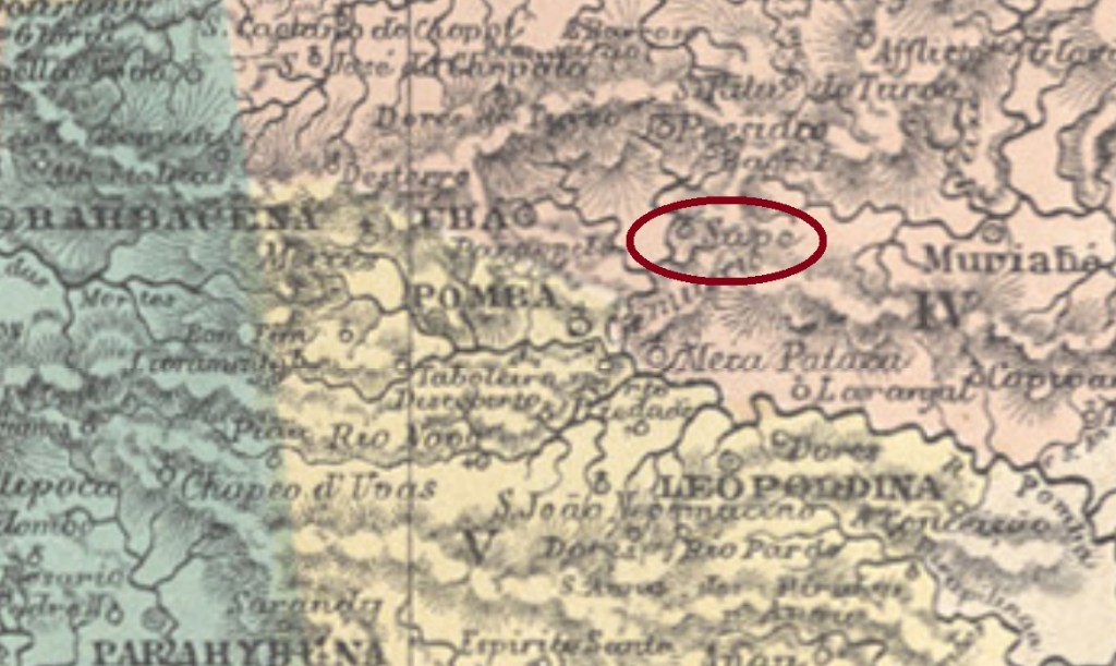
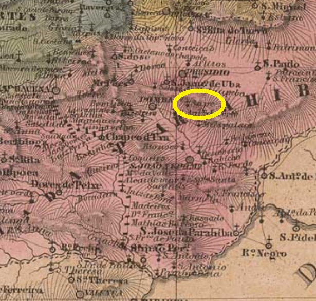
Sapé is a tupi word (yasa’pe) that names generically the reeds used by indians to make thatched roofs. This Sant’Anna do Sapé originated from the old district of Sapé de Ubá, founded in October 1851 in the municipality of Presídio de Ubá (the actual Visconde do Rio Branco), situated on the Chopotó River, round 180 km southwest of the provincial capital Ouro Preto. In May 1856 it was elevated to the freguesia of Sant’Anna do Sapé, which simplified the toponym in September 1923 to Sapé. Since December 1948 it is the municipality of Guidoval. This was the name of a local fazenda whose owner, the Frenchman Guido Thomaz Marlière (1767-1836), played a very important role in the colonization and indian pacification in the whole region. The municipality of Marliéria in Minas Gerais is also named after him.
According to Paula Sobrinho (História Postal de Minas Gerais, Belo Horizonte, 1997), the post office was created in September 1879. One cancel of the Empire is known: SMG-2725a was used at least between 1885 and 1898, having been already presented by Paulo Ayres (Catálogo de Carimbos Brasil-Império, S. Paulo, 1937, 1942):
SMG-2725a (P. Ayres, op. cit)Villiers de l’Ile Adam: Carta (…) da Provincia de Minas Geraes, 1849
Andere Namen: Sapê, Sapé de Ubá, Guidoval (1948)
Sapé ist ein Allgemeinbegriff der Tupi-Sprache (yasa’pe), der den Schilf bezeichnet, der von Indianern für den Bau von Reetdächern gebraucht wird. Diese Sant’Anna do Sapé war früher der Distrikt von Sapé de Ubá, der im Oktober 1851 im Município von Presídio de Ubá (heute Visconde do Rio Branco) gegründet wurde und am Fluss Chopotó lag, rund 180 km südwestlich der Provinzhauptstadt Ouro Preto entfernt. Im Mai 1856 stieg er zur Freguesia von Sant’Anna do Sapé auf, die im September 1923 den vereinfachten Namen Sapé erhielt. Seit Dezember 1948 ist es der Município von Guidoval. So hieß eine Fazenda der Gegend, dessen Besitzer, der Franzose Guido Thomaz Marlière (1767-1836), eine wichtige Rolle bei der Kolonisierung der Region und der Befriedung der Indianer spielte. Auch die Stadt Marliéria in Minas Gerais ist nach ihm genannt.
Laut Paula Sobrinho (História Postal de Minas Gerais, Belo Horizonte, 1997) gibt es dort ein Postamt seit September 1879. Ein Stempel im Kaiserreich ist bekannt: SMG-2725a war zumindest zwischen 1885 und 1898 in Gebrauch und wurde bereits durch Paulo Ayres (Catálogo de Carimbos Brasil-Império, S. Paulo, 1937, 1942) bekannt gemacht:
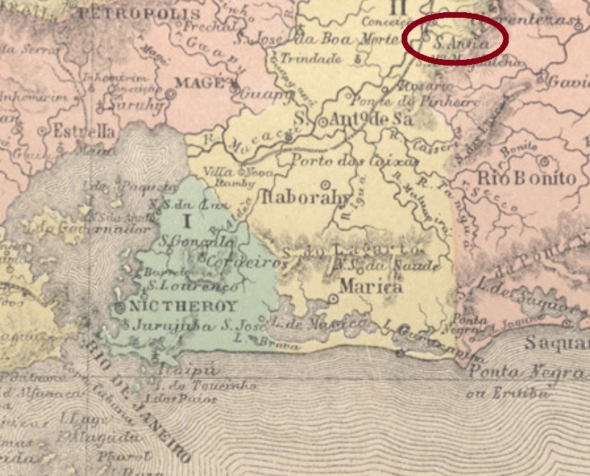
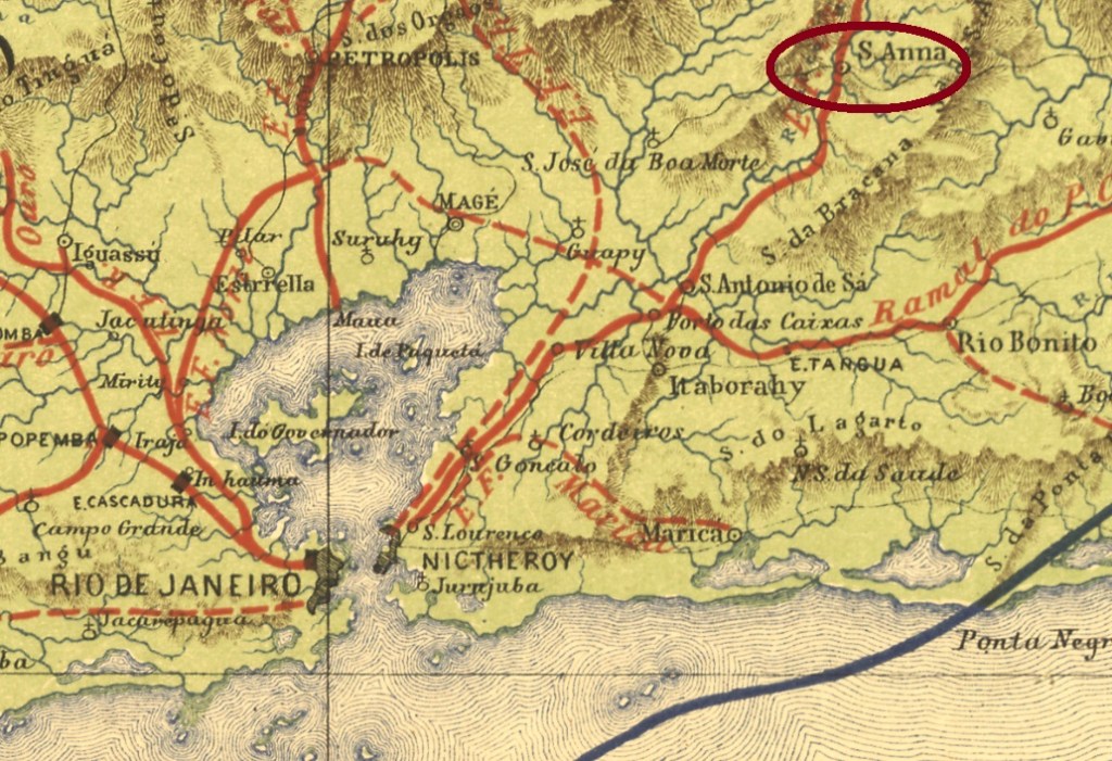
Other names: Sant’Anna do Macacu, Sant’Anna do Japuíba, Japuíba (1943)
See also Sant’Anna do Macacu (SRJ-1530)
The Arraial of Sant’Anna da Santissima Trindade (= of the Holiest Trinity) was founded in November 1868 on the east bank of the Macacu River, round 100 km northeast of the imperial capital Rio de Janeiro, and belonged to the now extinguished Villa of Santo Antonio de Sá. In September 1877 it ascended to a Villa under the name of Santa’Anna de Macacu, which changed the toponym to Sant’Anna de Japuíba in December 1898. It received even the town status in December 1929, but apparently has not improved significantly since then, for it was degraded to the district of Santana in the municipality of Cachoeiras in December 1938. Five years later it was renamed Japuíba, and Cachoeiras became Cachoeiras de Macacu.
Fur later cancels of this locality see Sant’Anna de Macacú (SRJ-1530).
E. F. Central do Brasil, 1890
Andere Namen: Sant’Anna do Macacu, Sant’Anna do Japuíba, Japuíba (1943)
Siehe auch Sant’Anna do Macacu (SRJ-1530)
Der Arraial (Dorf) von Sant’Anna da Santissima Trindade (= der Heiligsten Dreifaltigkeit) wurde im November 1868 am Ostufer des Flusses Macacu gegründet, lag rund 100 km nordöstlich der kaiserlichen Hauptstadt Rio de Janeiro entfernt und gehörte der inzwischen ausgelöschten Villa von Santo Antonio de Sá. Im September 1877 stieg er zur Villa auf, mit dem Namen Santa’Anna de Macacu, der allerdings im Dezember 1898 zu Sant’Anna de Japuíba wechselte. Er wurde im Dezember 1929 sogar eine Stadt, die allerdings nicht besonders gut gedeihte: schon im Dezember 1938 wurde sie zum Distrikt von Santana im Município von Cachoeiras degradiert. Fünf Jahre später kehrte der Ortsname Japuíba zurück, während aus Cachoeiras Cachoeiras de Macacu wurde.
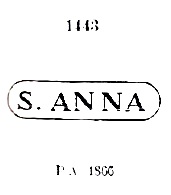
Laut Nova Monteiro (Administrações e Agencias Postaes do Brasil Imperio, in Brasil Filatelico/RJ, 1934-5; Reprint SPP 1994-1999) gibt es dort ein Postamt seit Mai 1832. Ein Stempel aus diesem früheren Zeitraum – SRJ-0860a – war bereits durch Paulo Ayres (Catálogo de Carimbos Brasil-Império, S. Paulo, 1937, 1942) unter # 1443 vorgestellt; er war zumindest zwischen 1843 and 1878 im Umlauf:
SRJ-0860a, P. Ayres Nr. 1443
Für spätere Entwertungen aus dieser Ortschaft siehe Sant’Anna de Macacú (SRJ-1530).
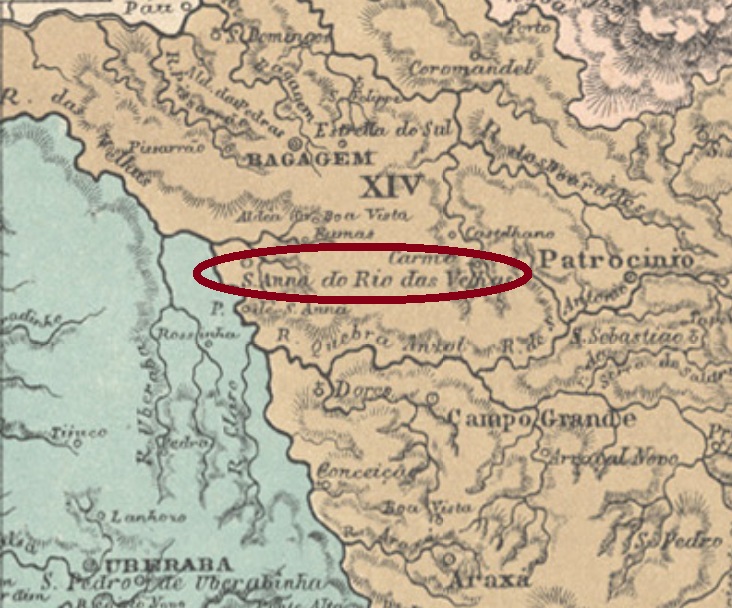
Other names: Sant’Anna da Barra do Rio das Velhas, Indianópolis (1938)
Again a Sant’Anna in the Minas Gerais province: this one was since September 1870 a district in the municipality of Araguary, situated over 600 km west of the ancient province capital Ouro Preto. In December 1938 it achieved the political emancipation under the municipal name of Indianópolis.
According to Paula Sobrinho (História Postal de Minas Gerais, Belo Horizonte, 1997), the local post office was created in August 1884. Only one early cancel was found, unfortunately only with dates between 1894 and 1899. SMG-2775a (Coll. Márcio Protzner) has a double circle with the inscription S’ANNA DO RIO DAS VELHAS above and a five-leg star below, with dates inside.
Villiers de l’Ile Adam: Carta (…) da Provincia de Minas Geraes, 1849
Andere Namen: Sant’Anna da Barra do Rio das Velhas, Indianópolis (1938)
Und wieder eine Sant’Anna in der Provinz Minas Gerais: diese war ab September 1870 ein Distrikt im Município von Araguary, der über 600 km westlich der ehemaligen Provinzhauptstadt Ouro Preto entfernt lag. Im Dezember 1938 erreichte er die politische Selbständigkeit als Município mit Namen Indianópolis.
Wie Paula Sobrinho (História Postal de Minas Gerais, Belo Horizonte, 1997) berichtet, gibt es dort ein Postamt seit August 1884. Nur ein früher Stempel wurde gefunden, leider nur mit Daten zwischen 1894 und 1899. SMG-2775a (Samml. Márcio Protzner) hat einen Doppelkreis mit der Inschrift S’ANNA DO RIO DAS VELHAS oben und einem fünfzackigen Stern unten, dazu das Datum in der Mitte.
See also Pirapetinga (R. Koester: Carimbologia XXXI)
The Pirapetinga or pirapitinga is a fish of the Characidae family (Piaractus brachypomus, Cuvier, 1818) that can reach up to 25 kg and also named a small river in the south of the Minas Gerais province. Sant’Anna do Pirapetinga was called the district founded in August 1864 in the municipality of São José d’Além Parahyba, situated round 300 km southeast of the provincial capital Ouro Preto. It emancipated in December 1938 as the town and municipality of Pirapetinga.
According to Nova Monteiro (Administrações e Agencias Postaes do Brasil Imperio, in Brasil Filatelico/RJ, 1934-5; Reprint SPP 1994-1999), the local post office was created in October 1865. Two early cancels are known. SMG-2770a (image from the internet) has a double circle with the inscription S.A. DE PIRAPETINGA. The dates in the inner circle were found for the period 1866-1886. It was followed by SMG-2770b (image from the internet). In this double circle the inscriptions are S. ANNA DO PIRAPETINGA above and (MINAS) below. Dates inside found for 1894-1905.
Atlas do Imperio do Brasil, 1868
Siehe auch Pirapetinga (R. Koester: Carimbologia XXI)
Pirapetinga oder Pirapitinga ist ein Fisch der Familie Characidae (Piaractus brachypomus, Cuvier, 1818), der bis 25 kg erreichen kann und seinen Namen auch einen Fluss im Süden der Provinz Minas Gerais gab. Sant’Anna do Pirapetinga hieß der Distrikt, der im August 1864 im Município von São José d’Além Parahyba gegründet wurde, rund 300 km südöstlich der Provinzhauptstadt Ouro Preto entfernt. Im Dezember 1938 stieg er zur Stadt im Município von Pirapetinga auf.
Wie Nova Monteiro (Administrações e Agencias Postaes do Brasil Imperio, in Brasil Filatelico/RJ, 1934-5; Reprint SPP 1994-1999) berichtet, gibt es dort ein Postamt seit Oktober 1865. Zwei frühe Stempel sind überliefert. SMG-2770a (Abb. aus dem Internet) hat einen Doppelkreis mit der Inschrift S.A. DE PIRAPETINGA. Die Daten im Innenkreis stammen aus dem Zeitraum 1866-1886. Ihm folgte SMG-2770b (Abb. aus dem Internet). In diesem Doppelkreis lauten die Inschriften S. ANNA DO PIRAPETINGA oben und (MINAS) unten. Daten im Innenkreis ermittelt zwischen 1894-1905.
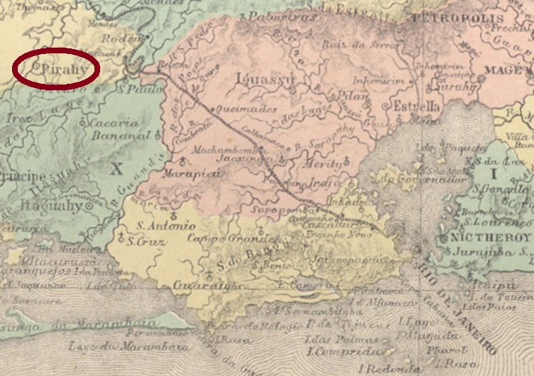
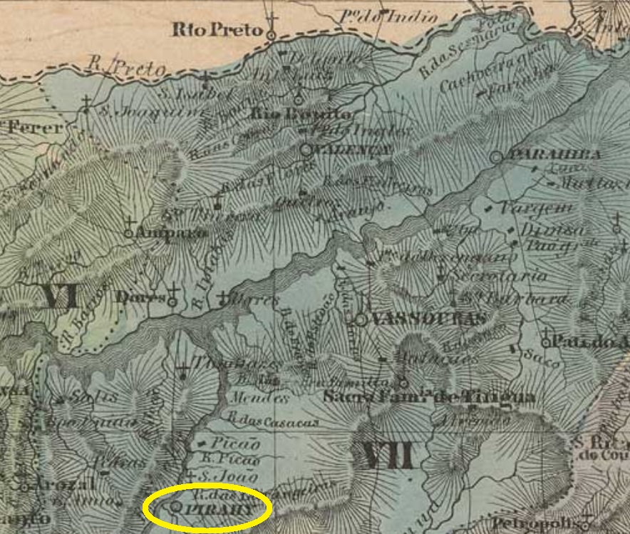
The old curato of Sant’Anna do Pirahy was created in October 1811 and declared a freguesia in October 1817 in the now extinct municipality of São João do Príncipe. It was situated round 100 km northwest of the imperial capital Rio de Janeiro and ascended to a villa in December 1837. It emancipated politically in October 1874, bearing since then the simplified toponym of Piraí.
According to Nova Monteiro (Administrações e Agencias Postaes do Brasil Imperio, in Brasil Filatelico/RJ, 1934-5; Reprint SPP 1994-1999), the local post office was created in October 1832. Only one imperial cancel featuring the entire name was found: SRJ-2365a was already presented by Henrique B. Ferreira (Catálogo ilustrado dos carimbos sobre os olhos-de-boi, 4a. ed, Porto Alegre, 2017, pg 164-5), as well as by the RHM catalogue under P-RJ-41 :
SRJ-2365a (H.B. Ferreira, op. cit.)
For later cancels featuring just PIRAHY see Koester’s Carimbologia XXXI.
Villiers de l’Ile Adam: Carta (…) da Provincia do Rio de Janeiro, 1850
Andere Namen: Sant’Anna, Pirahy
Siehe auch R. Koester: Carimbologia XXXI)
Der alte Curato von Sant’Anna do Pirahy wurde im Oktober 1811 gegründet und sechs Jahre später zur Freguesia erklärt. Er lag im inzwischen ausgestorbenen Município von São João do Príncipe, rund 100 km nordwestlich der kaiserlichen Hauptstadt Rio de Janeiro entfernt. Im Dezember 1837 wurde daraus eine Villa und im Oktober 1874 eine Stadt, die seitdem den vereinfachten Namen Piraí trägt.
Nova Monteiro (Administrações e Agencias Postaes do Brasil Imperio, in Brasil Filatelico/RJ, 1934-5; Reprint SPP 1994-1999) setzt das Gründungsdatum des örtlichen Postamts in October 1832. Lediglich eine postalische Entwertung der Kaiserzeit wurde bisher mit vollständigem Namen gefunden: SRJ-2365a wurde uns bereits durch Henrique B. Ferreira (Catálogo ilustrado dos carimbos sobre os olhos-de-boi, 4a. ed, Porto Alegre, 2017, pg 164-5), sowie durch den RHM Katalog (P-RJ-41) vorgestellt:
SRJ-2365a (H.B. Ferreira, op. cit.)
Für spätere Stempel nur mit der Inschrift PIRAHY siehe Koesters Carimbologia XXXI.