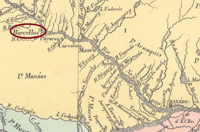
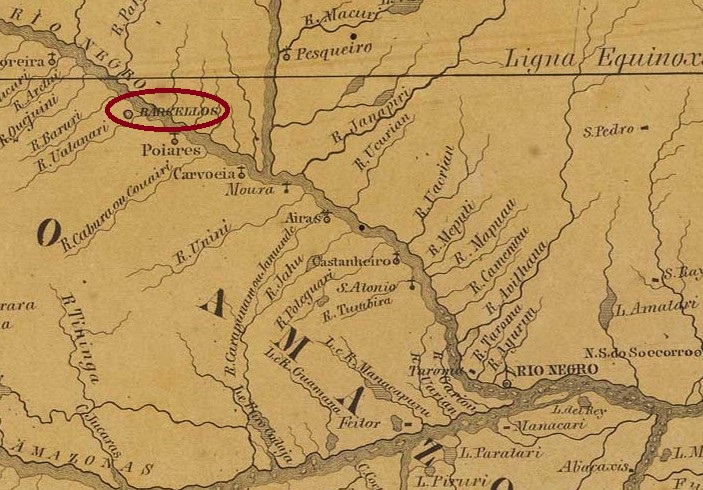
This locality was already declared a Vila in May 1758 and functioned as the capital of the former Capitania of Rio Negro until 1790. It was located on the south bank of the Rio Negro, 400 km northwest of the later capital Manaus. After Brazil’s independence in 1822, it belonged to the province of Grão-Pará until 1850, when the province of Amazonas was created. After that, Barcellos was twice downgraded as a freguesia or district of the Vila of Moura: in October 1878 and in November 1930. Subsequently came two upgrades as a vila in its own município: in June 1881 and in September 1931. Since August 1938, Barcelos (as it is written today) has been a city.
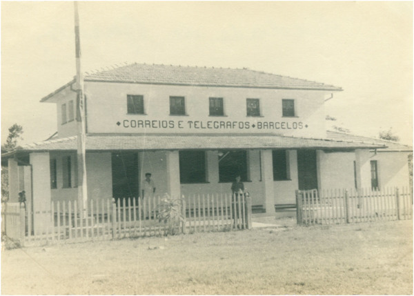
The post office in Barcelos, ca. 1970 (IBGE)
Three dates have been found for the emergence of the local post office, yet no imperial postmark. First in March 1829, as R. Koester writes in Carimbologia III. Then in March 1846, as one can read in Nova Monteiro’s Administrações e Agencias Postaes do Brasil Imperio (Brasil Filatelico/RJ, 1934-5; Reprint SPP 1994-1999). And finally in 1884 – that is, for the first time in the province of Amazonas, as can be seen from the Directory of Imperial Post Offices (Tabella das Agencias do Correio do Imperio, Rio de Janeiro, 1885).
So far, no postmark of the imperial period could be assigned to this locality.
Villiers de l’Ile Adam: Carta (…) das Provincias do Grão-Para e Alto Amazonas, 1850
Diese Ortschaft war bereits im Mai 1758 zur Vila erklärt und fungierte als Hauptstadt der ehemaligen Capitania von Rio Negro bis 1790. Sie lag am Südufer des Rio Negro, 400 km nordwestlich der späteren Hauptstadt Manaus entfernt. Nach der Unabhängigkeit Brasiliens 1822 gehörte sie der Provinz Grão-Pará bis 1850, als die Provinz Amazonas entstand. Danach wurde Barcellos zweimal als Freguesia bzw. Distrikt der Vila von Moura herabgestuft: im Oktober 1878 und im November 1930. In der Folge kamen zwei Aufstiege als Vila im eigenen Município: im Juni 1881 und im September 1931. Seit August 1938 ist Barcelos (wie man es heute schreibt) eine Stadt.
Das Postamt in Barcelos, ca. 1970 (IBGE)
Es wurden drei Zeitpunkte zur Entstehung des örtlichen Postamts gefunden, aber noch kein kaiserlicher Poststempel. Erstmals im März 1829, wie R. Koester in Carimbologia III schreibt. Dann im März 1846, wie man in Nova Monteiros Administrações e Agencias Postaes do Brasil Imperio (Brasil Filatelico/RJ, 1934-5; Reprint SPP 1994-1999) lesen kann. Und schließlich 1884 – also erstmals unter der Provinz Amazonas, wie aus dem Verzeichnis der kaiserlichen Postämter (Tabella das Agencias do Correio do Imperio, Rio de Janeiro, 1885) entnommen werden kann.
Bisher konnte kein Poststempel der Kaiserzeit dieser Ortschaft zugeordnet werden.
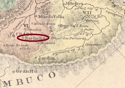
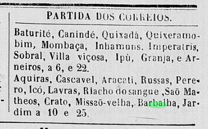
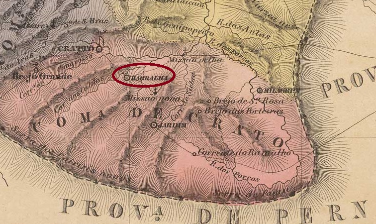
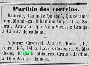
The parish of Santo Antonio da Barbalha was founded in August 1838 and was located near the Vila of Crato, 500 km south of the provincial capital Fortaleza. The place rose to the status of vila in August 1846 and town in August 1876.
As Nova Monteiro writes in Administrações e Agencias Postaes do Brasil Imperio (Brasil Filatelico/RJ, 1934-5; Reprint SPP 1994-1999), there was a post office there since August 1866, but regional press reports postal routes had passed through Barbalha even before that date, at least between October 1849 and April 1865:
O Cearense, 15.10.1849O Cearense, 18.04.1865
Since it is hard to imagine an honorary post office clerk at work for over 15 years, it could well be that a post office has operated there, however.
The only imperial postmark from Barbalha so far is BCE-0040a, already shown by Paulo Ayres in Catálogo de Carimbos Brasil-Império, (S. Paulo, 1937, 1942):
BCE-0040a(P.A. p. 145)
Later, BCE-0040c (fig. from the internet) also appeared: a double circle with the inscriptions BARBALHO (sic!) above and (CEARÁ) below. The dates so far come from the period 1902-1903.
Villiers de l’Ile Adam: Carta (…) da Provincia do Ceara, 1849
Die Pfarrei von Santo Antonio da Barbalha wurde im August 1838 gegründet und lag bei der Vila von Crato, 500 km südlich der Provinzhauptstadt Fortaleza entfernt. Der Ort stieg im August 1846 zur Vila und im August 1876 zur Stadt auf.
Wie Nova Monteiro in Administrações e Agencias Postaes do Brasil Imperio (Brasil Filatelico/RJ, 1934-5; Reprint SPP 1994-1999) schreibt, gab es ein Postamt dort seit August 1866. In der Regionalpresse liest man aber, dass Postrouten durch Barbalha schon vorher, zumindest zwischen Oktober 1849 und April 1865 gingen:
O Cearense, 15.10.1849O Cearense, 18.04.1865
Da es ein Ehrenamt als Postangestellter über 15 Jahre lang schwer vorstellbar ist, könnte es gut sein, dass ein Postamt dort wie auch immer betrieben wurde.
Der bisher einzige kaiserliche Poststempel aus Barbalha ist BCE-0040a, der bereits durch Paulo Ayres in Catálogo de Carimbos Brasil-Império, (S. Paulo, 1937, 1942) gezeigt wurde:
BCE-0040a (P.A. S. 145)
Später erschien auch BCE-0040c (Abb. aus dem Internet): ein Doppelkreis mit den Inschriften BARBALHO (sic!) oben und (CEARÁ) unten. Die Daten kommen bisher aus dem Zeitraum 1902-1903.
Other names: Capela da Borda do Campo, Igreja Nova
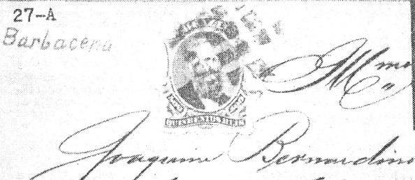
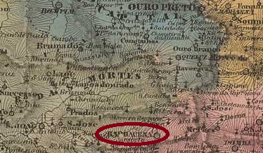
The freguesia of N. Sa. da Piedade da Borda do Campo was created by royal decree in 1725, located 130 km south of the Capitania capital Vila Rica (later: Ouro Preto). Between 1748 and 1752 (sources disagree), the parish moved to the neighbouring Igreja Nova, which at that time belonged to the Vilas of S. José and S. João d’El-Rei. Then, in August 1791, the ascension to a vila took place, called Barbacena, as the then governor of the Capitania of Minas Gerais was the Vicomte de Barbacena. Its name in turn came from a small town in the upper Alentejo in Portugal (662 inhabitants in 2011). Barbacena has been a town in Minas Gerais since March 1840.
Four dates have been found for the creation of the local post office, a sure indication that it was closed in between. First in May 1809, as Paula Sobrinho writes in História Postal de Minas Gerais (Belo Horizonte, 1997). Then in March 1829, as one can read in Nova Monteiro’s Administrações e Agencias Postaes do Brasil Imperio (Brasil Filatelico/RJ, 1934-5; Reprint SPP 1994-1999). Then again in October 1833, as noted both in the Postal Report (Relatorio Postal) for 1887 and in the Directory of Imperial Post Offices (Tabella das Agencias do Correio do Imperio, Rio de Janeiro, 1885). And finally in June 1838, as Paula Sobrinho (op. cit.) also noted.
The first postmark is BMG-0220a, which also occurs in sepia and was used between 1818 and at least 1843. A frameless variant of this cancel is also said to exist. However, all illustrations so far show clear remnants of the cancel frame. The postmark became known through the RHM catalogue, under P-MG-09:
BMG-0220a (RHM P-MG-09)
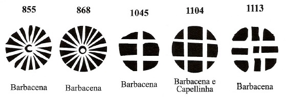
It was followed by BMG-0220b, in use around 1843, also occurring in sepia and listed both in the Paulo Ayres’s Catálogo de Carimbos Brasil-Império (S. Paulo, 1937, 1942) under no. 1228 and in the RHM catalogue as well:
BMG-0220b (P.A. 1228, RHM P-MG-07)
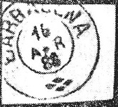
The next three postmarks are double circles, as presented by R. Koester in Carimbologia III:
BMG-0220c (RK) 1874-1886, which also exists in greenBMG-0220d (RK) 1883-1884BMG-0220e (RK) 1887-1891
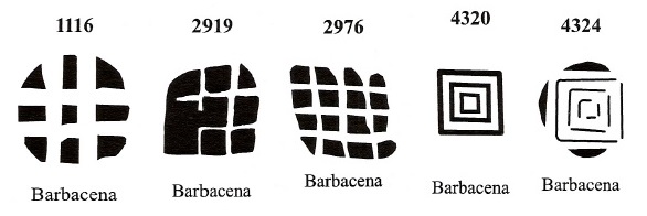
In Mute Cancellations of the Brazil Empire / Carimbos Mudos do Brasil Império (Brazil Philatelic Association, Rio de Janeiro, 2000) James Dingler and Klerman W. Lopes presented ten mute cancellations from the imperial Barbacena:
Another mute cancellation was shown by R. Koester (op. cit.):
1867 (RK)Villiers de l’Ile Adam: Carta (…) da Provincia de Minas Geraes, 1849
Andere Namen: Capela da Borda do Campo, Igreja Nova
Die Freguesia von N. Sa. da Piedade da Borda do Campo entstand 1725 durch königliche Verfügung und lag 130 km südlich der Capitania-Hauptstadt Vila Rica (später: Ouro Preto). Zwischen 1748 und 1752 (die Quellen sind sich nicht einig) wechselte die Pfarrei zur benachbarten Igreja Nova, die damals den Vilas von S. José und S. João d’El-Rei angehörte. Im August 1791 erfolgte dann der Aufstieg zu einer Vila, die Barbacena hieß, da der damalige Gouverneur der Capitania von Minas Gerais der Vicomte de Barbacena war. Sein Name wiederum kam von einer kleinen Gemeinde am oberen Alentejo in Portugal (662 Einwohner im Jahr 2011). Seit März 1840 ist Barbacena in Minas Gerais eine Stadt.
Es wurden vier Daten für die Entstehung des örtlichen Postamts gefunden, ein sicheres Indiz dafür, dass es zwischendurch geschlossen war. Erstmals im Mai 1809, wie Paula Sobrinho in História Postal de Minas Gerais (Belo Horizonte, 1997) schreibt. Dann im März 1829, wie man im Nova Monteiros Administrações e Agencias Postaes do Brasil Imperio (Brasil Filatelico/RJ, 1934-5; Reprint SPP 1994-1999) lesen kann. Dann wieder im Oktober 1833, wie sowohl im Postbericht (Relatorio Postal) für 1887 als auch im Verzeichnis der kaiserlichen Postämter (Tabella das Agencias do Correio do Imperio, Rio de Janeiro, 1885) vermerkt. Und schließlich im Juni 1838, wie Paula Sobrinho (op. cit.) ebenfalls notierte.
Der erste Poststempel ist BMG-0220a, der auch in sepia vorkommt und zwischen 1818 und mindestens 1843 verwendet wurde. Von diesem Stempel soll auch eine rahmenlose Variante vorkommen. Allerdings zeigen bisher alle Abbildungen deutliche Reste des Stempelrahmens. Bekannt wurde der Poststempel durch den RHM-Katalog, unter P-MG-09:
BMG-0220a (RHM P-MG-09)
Ihm folgte BMG-0220b, der wohl um 1843 in Gebrauch war, auch in sepia vorkommt und sowohl im Paulo Ayres Catálogo de Carimbos Brasil-Império (S. Paulo, 1937, 1942) unter Nr. 1228 als auch im RHM-Katalog aufgelistet wurde:
BMG-0220b (P.A. 1228, RHM P-MG-07)
Die nächsten drei Poststempel sind Doppelkreise, die allesamt durch R. Koester in Carimbologia III vorgestellt wurden:
BMG-0220c (RK) 1874-1886, existiert auch in grünBMG-0220d (RK) 1883-1884BMG-0220e (RK) 1887-1891
In Mute Cancellations of the Brazil Empire / Carimbos Mudos do Brasil Império (Brazil Philatelic Association, Rio de Janeiro, 2000) haben James Dingler und Klerman W. Lopes zehn stumme Abstempelungen aus dem kaiserlichen Barbacena präsentiert :
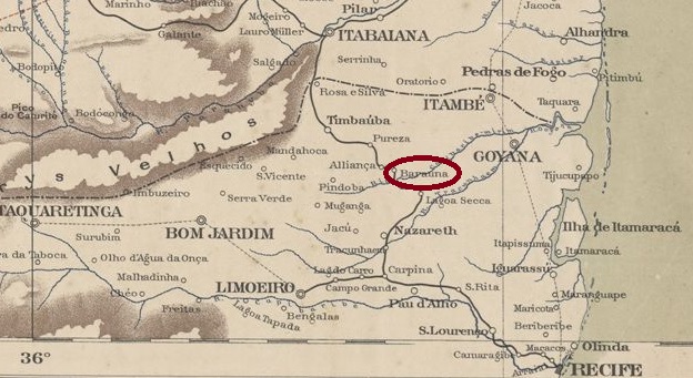
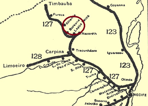
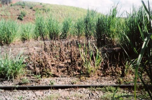
Baraúna station was inaugurated in January 1883 by the Great Western Railway Company and was located close to the banks of the Sirgi River in the Município of Nazaré, 90 km northwest of the provincial capital Recife. Since July 1909, the surrounding area has belonged to the Município of Aliança. The railway line went to Rede Ferroviária do Nordeste in 1950, and from 1975 until its closure in 1996 it belonged to Rede Ferroviária Federal S.A. (estacoesferroviarias.com.br). Today the station building is demolished, the rails are still there.
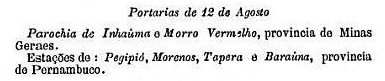
A station post office existed from August 1889, as can be read in the Boletim Postal of the following month:
Boletim Postal No. 5, September 1889
No imperial postmark from this station has been seen so far.
Rede Ferroviaria, 1898
Der Bahnhof Baraúna wurde im Januar 1883 durch die Great Western Bahngesellschaft eingeweiht und lag nah am Ufer des Flusses Sirgi im Município von Nazaré, 90 km nordwestlich der Provinzhauptstadt Recife entfernt. Seit Juli 1909 gehört die Umgebung zum Município von Aliança. Die Bahnlinie ging 1950 zur Rede Ferroviária do Nordeste, und von 1975 bis zur Stilllegung 1996 gehörte sie der Rede Ferroviária Federal S.A. (estacoesferroviarias.com.br). Heute ist das Bahnhofsgebäude abgerissen, die Schienen sind noch da.
Foto Sidney Correia (estacoesferroviarias.com.br)
Ein Bahnhofspostamt gab es seit August 1889, wie im Boletim Postal des Folgemonats zu lesen ist:
Boletim Postal Nr. 5, September 1889
Bisher war kein kaiserlicher Poststempel aus diesem Bahnhof zu sehen.
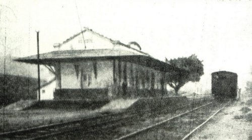
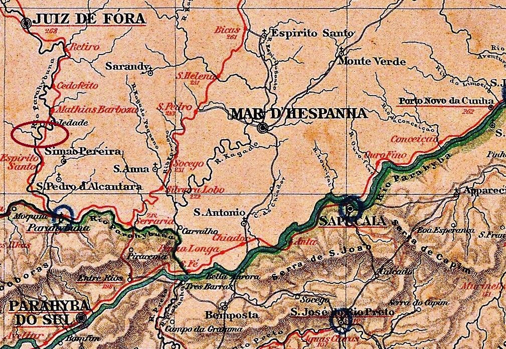
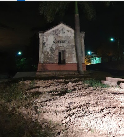
Barão de Cotegipe station was inaugurated in November 1885 by the E.F. Dom Pedro II railway company (Central Line) and was located at the confluence of the Rio do Peixe and the Paraibuna, in the Município of Juiz de Fora, 240 km south of the provincial capital Ouro Preto. In 1889, the railway line went to E.F. Central do Brasil and from 1975 until its closure in 1996, it belonged to Rede Ferroviária Federal S.A. (estacoesferroviarias.com.br). Today, the rails are still there, but the station building has been abadoned:
ca.1915 (Album de Juiz de Fora, in estacoesferroviarias.com.br)2000 (Photo: Victor Chrispim)
With the Republic, the station was renamed Cotegipe. The Baron of Cotegipe’s real name was João Mauricio Wanderley (1815-1889), he was an important politician in the Empire. From September 1923, the station belonged to the Município of Mathias Barbosa, and since December 1962 it has been in the Município of Simão Pereira.
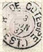
As Paula Sobrinho writes in História Postal de Minas Gerais (Belo Horizonte, 1997), there was a post office at the station since December 1885. The first imperial postmark is now BMG-0215a (Fig. Felzmann Auctions):
BMG-0215a (FA) 1887
Its successor BMG-0215b (illustration from the Internet): a double circle with the inscriptions B. DO COTEGIPE at the top and (MINAS) at the bottom. The dates in the middle are from the period 1888-1897.
Almanak Laemmert, 1892
Textaktualisierung am 18. März 2024
Anderer Name: Cotegipe
Der Bahnhof Barão de Cotegipe wurde im November 1885 durch die E.F. Dom Pedro II Bahngesellschaft (Hauptlinie) eingeweiht und lag an der Mündung vom Rio do Peixe in den Paraibuna, im Município von Juiz de Fora, 240 km südlich der Provinzhauptstadt Ouro Preto enfernt. 1889 ging die Bahnlinie zur E.F. Central do Brasil und von 1975 bis zur Stilllegung 1996 gehörte sie der Rede Ferroviária Federal S.A. (estacoesferroviarias.com.br). Heute sind die Schienen noch da, aber das Bahnhofsgebäude ist verwahrlost:
Ca.1915 (Album de Juiz de Fora, in estacoesferroviarias.com.br)2000 (Foto: Victor Chrispim)
Mit der Republik wurde der Bahnhof zu Cotegipe umbenannt. Der Baron von Cotegipe hieß eigentlich João Mauricio Wanderley (1815-1889) und war ein wichtiger Politiker im Kaiserreich. Ab September 1923 gehörte der Bahnhof dem Município von Mathias Barbosa, und seit Dezember 1962 liegt er im Município von Simão Pereira.
Wie Paula Sobrinho in História Postal de Minas Gerais (Belo Horizonte, 1997) schreibt, gab es am Bahnhof ein Postamt seit Dezember 1885. Der erste kaiserliche Poststempel ist inzwischen BMG-0215a (Abb. Felzmann Auctions):
BMG-0215a (FA) 1887
Sein Nachfolger BMG-0215b (Abb. aus dem Internet): ein Doppelkreis mit den Inschriften B. DO COTEGIPE oben und (MINAS) unten. Die Daten in der Mitte entstammen dem Zeitraum 1888-1897.
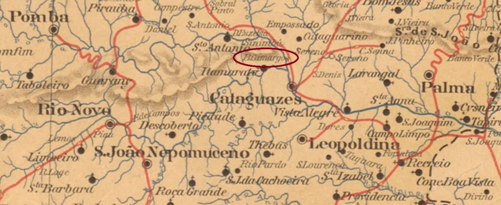
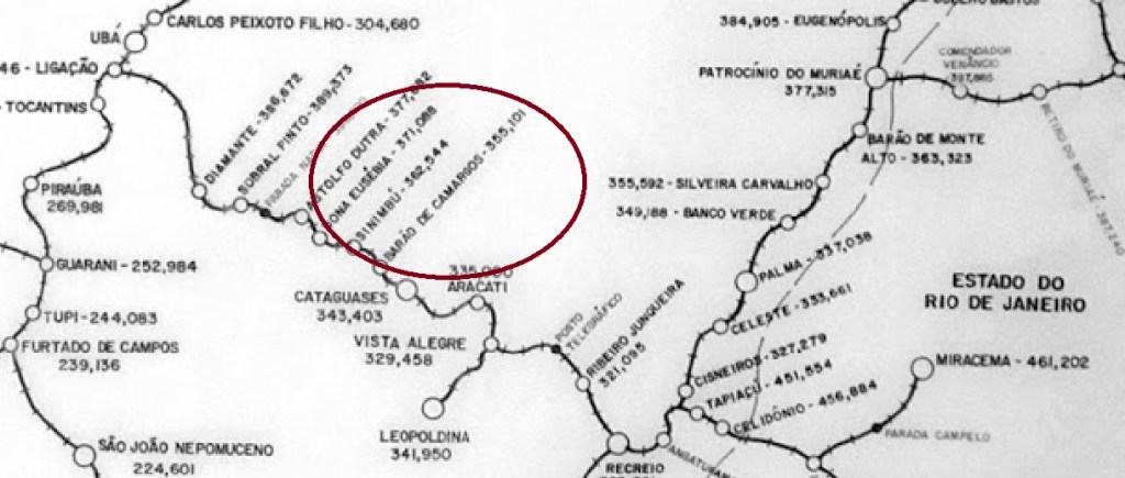
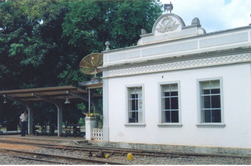
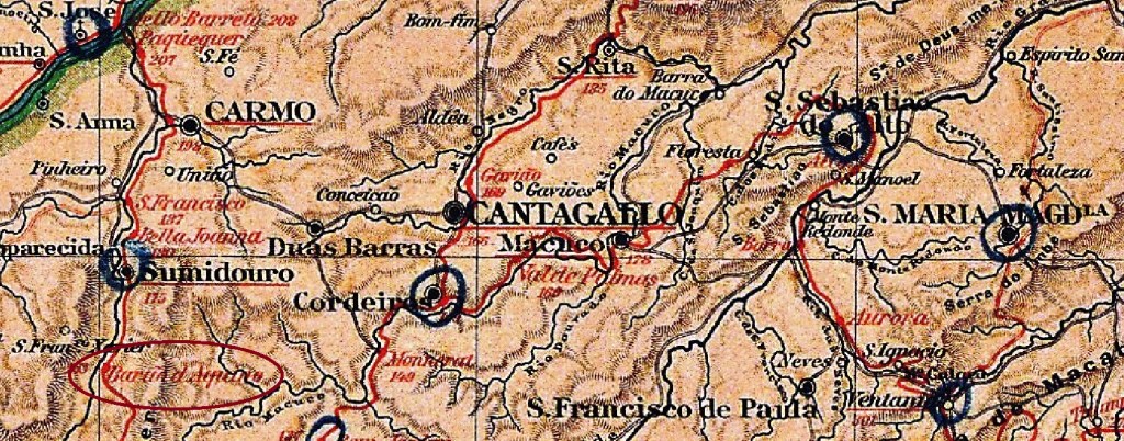
Inaugurated in September 1885 by the E.F. Leopoldina Railway Company (Recreio Branch), Barão de Camargos station was located on the east bank of the Pomba River in the Município of Cataguazes, 210 km southeast of the provincial capital of Ouro Preto. From 1975 until its closure in 1996, the railway line belonged to Rede Ferroviária Federal S.A. (estacoesferroviarias.com.br). Today the rails are still there, but the station building has been demolished. The place is now host to a mining company that extracts bauxite.
ca. 2004 (Photo : Gutierrez Coelho, in estacoesferroviarias.com.br)
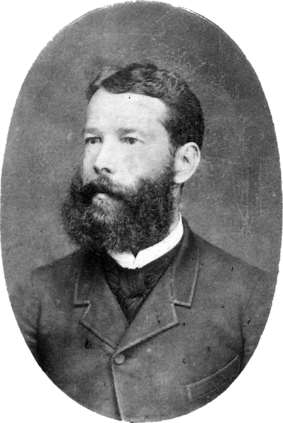
There were two barons of Camargos in imperial Brazil. The first was called Manuel Teixeira de Souza (1811-1878), he was a large landowner and senator. His son Antonio Teixeira de Souza Magalhães (1848-1912) studied medicine but became provincial president of Minas Gerais six times for a short period:
Antonio Teixeira de Souza Magalhães, 2nd Baron of Camargos
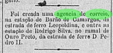
As the Rio press reported, there had been a post office at the station since January 1889:
Diario do Commercio/RJ, 01.02.1889
The postmark from the imperial period is BMG-0210a (image from the Internet): a double circle with the inscriptions BARÃO DE CAMARGOS above and (MINAS) below. The only specimen so far bears a date from 1890 in the centre.
Estrada de Ferro Leopoldina
Der Bahnhof Barão de Camargos wurde im September 1885 durch die E.F. Leopoldina Bahngesellschaft (Recreio-Abzweigung) eingeweiht und lag am Ostufer des Flusses Pomba im Município von Cataguazes, 210 km südöstlich der Provinzhauptstadt Ouro Preto entfernt. Von 1975 bis zur Stilllegung 1996 gehörte die Bahnstrecke der Rede Ferroviária Federal S.A. (estacoesferroviarias.com.br). Heute sind die Schienen noch da, aber das Bahnhofsgebäude wurde abgerissen. Der Ort ist nun Sitz einer Bergbaufirma, die Bauxit abbaut.
ca. 2004 (Foto : Gutierrez Coelho, in estacoesferroviarias.com.br)
Es gab zwei Baronen von Camargos im kaiserlichen Brasilien. Der erste hieß Manuel Teixeira de Souza (1811-1878), er war Großgrundbesitzer und Senator. Sein Sohn Antonio Teixeira de Souza Magalhães (1848-1912) hat zwar Medizin studiert, wurde aber sechsmal für jeweils kurze Zeit Provinzpräsident von Minas Gerais:
Antonio Teixeira de Souza Magalhães, 2. Baron von Camargos
Wie die Presse aus Rio berichtete, gab es ein Postamt am Bahnhof seit Januar 1889:
Diario do Commercio/RJ, 01.02.1889
Der Poststempel aus der Kaiserzeit ist BMG-0210a (Abb. aus dem Internet): ein Doppelkreis mit den Inschriften BARÃO DE CAMARGOS oben und (MINAS) unten. Das bisher einzige Exemplar trägt ein Datum aus 1890 in der Mitte.
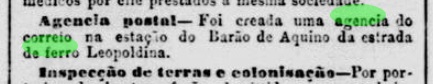
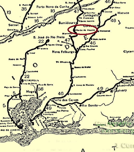
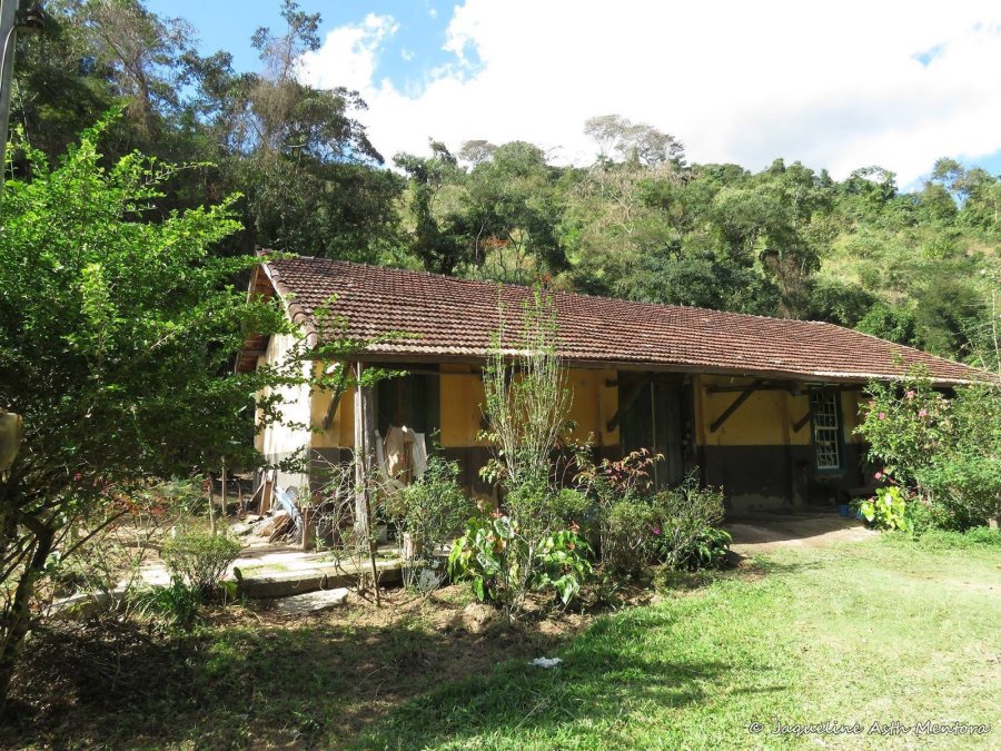
The Barão de Aquino station was inaugurated in March 1889 by the E.F. Leopoldina Railway Company (Sumidouro Branch), close to the east bank of the Paquequer River in the Município of Carmo, 170 km northeast of the capital Rio de Janeiro. From June 1890, it was in the Município of Sumidouro. The railway line was closed in 1967, the rails were taken off and the station building is now used as a residence (estacoesferroviarias.com.br):
Ca. 2017 (Photo: Jaqueline Mentora, in estacoesferroviarias.com.br)
As reported by the Rio press, there had been a railway station post office there since March 1889:
Jornal do Commercio, 27/03/1889
The imperial postmark here is BRJ-0115a (image: Luis C. Fritzen): a double circle with the inscriptions BARÃO DE AQUINO above and (EST.) below. The dates in the centre so far go from 1889 to 1891.
Estrada de Ferro Leopoldina, 1898
Der Bahnhof Barão de Aquino wurde im März 1889 durch die E.F. Leopoldina Bahngesellschaft (Sumidouro-Abzweigung) eingeweiht und lag nah am Ostufer des Flusses Paquequer im Municipio von Carmo, 170 km nordöstlich der Hauptstadt Rio de Janeiro entfernt. Ab Juni 1890 lag er im Município von Sumidouro. Die Bahnlinie wurde 1967 stillgelegt, die Schienen wurden abgerissen, und das Bahnhofsgebäude dient heute als Wohnhaus (estacoesferroviarias.com.br):
Ca. 2017 (Foto: Jaqueline Mentora, in estacoesferroviarias.com.br)
Wie die Presse aus Rio berichtete, gab es dort ein Bahnhofspostamt seit März 1889:
Jornal do Commercio, 27.03.1889
Der kaiserliche Poststempel dazu ist BRJ-0115a (Abb. Luis C. Fritzen): ein Doppelkreis mit den Inschriften BARÃO DE AQUINO oben und (EST.) unten. Die Daten in der Mitte gehen bisher von 1889 bis 1891.
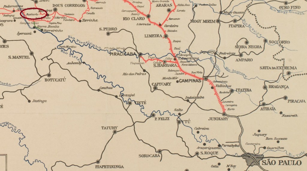
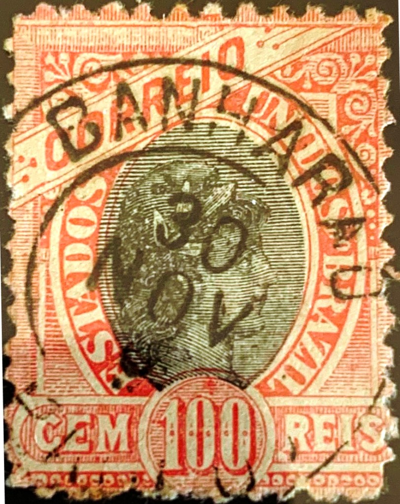
There were two railway stations in São Paulo called Banharão. This is the older one, inaugurated in February 1887 by the E.F. Rio Clarense Railway Company, Jaú Branch, and was then located on the north bank of the Tietê River in the Município of Dois Córregos, 270 km northwest of the capital São Paulo. The railway line changed to the Rio Claro Railway in 1888 and belonged to Companhia Paulista from 1892 until it was closed in 1941. Then a new line was built, which required a new station. The area around the old station, which had been demolished in the meantime, became part of the newly founded Município of Mineiros in August 1899, which has been called Mineiros do Tietê since November 1944.
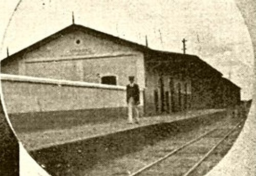
Ca. 1919 (Photo: Filemon Pires, in estacoesferroviarias.com.br)
Philatelist Mário Celso Orsi Jr. writes that there was a station post office there from February 1887. However, a note from the regional press shows that the agency was created a month later:
Correio Paulistano, 18/03/1887
In the meantime, the postmark BSP-0095a (Fig. Felipe Piccinini) has been found, which should be the first from this station:
BSP-0095a (FP) 1888-1891
The successor BSP-0095b (coll. Alexandre Andrade) was found on a stamp from 1894:
BSP-0095b (AA) 1894ffGoogle Maps
Textaktualisierung am 15. März 2025
Es gab zwei Bahnhöfe in São Paulo, die Banharão hießen. Dieser ist der Ältere, im Februar 1887 durch die E.F. Rio Clarense Bahngesellschaft, Jaú Abzweigung, eingeweiht, und lag damals am Nordufer des Flusses Tietê im Município von Dois Córregos, 270 km nordwestlich der Hauptstadt São Paulo entfernt. Die Bahnlinie wechselte 1888 zur Rio Claro Railway und gehörte von 1892 bis zur Stilllegung 1941 der Companhia Paulista. Dann kam eine Neubaustrecke für die Linie, die ein neuer Bahnhof erforderlich machte. Die Region um den inzwischen abgerissenen Altbahnhof ging im August 1899 zum neu gegründeten Município von Mineiros, der seit November 1944 Mineiros do Tietê heißt.
Ca. 1919 (Foto: Filemon Pires, in estacoesferroviarias.com.br)
Der Philatelist Mário Celso Orsi Jr. schreibt, dass es dort ab Februar 1887 ein Bahnhofspostamt gab. Eine Note der Regionalpresse zeigt allerdings, dass die Agentur ein Monat später entstanden ist:
Correio Paulistano, 18.03.1887
Inzwischen wurde der Poststempel BSP-0095a (Abb. Felipe Piccinini) gefunden, der der erste von diesem Bahnhof sein soll:
BSP-0095a (FP) 1888-1891
Auf einer Briefmarke von 1894 fand sich der Nachfolger BSP-0095b (Samml. Alexandre Andrade):
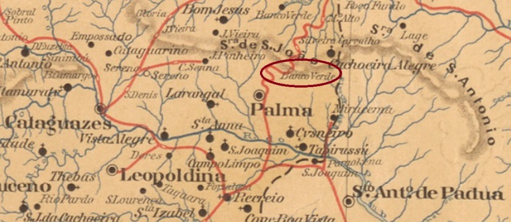
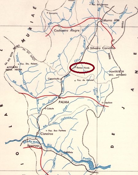
The Banco Verde (Green Bank) railway station was inaugurated in December 1884 by the E.F. Leopoldina railway company (Manhuassú line) and was located in the Município of Cataguazes, 260 km south-east of the provincial capital Ouro Preto. The railway line switched to Rede Ferroviária Federal S.A. in 1975 and was closed in 1979. Today, the rails are gone and the station is a ruin (estacoesferroviarias.com.br). Since December 1890, the station has been located in the Município of S. Francisco do Capivara, which has been called Palma since March 1891.
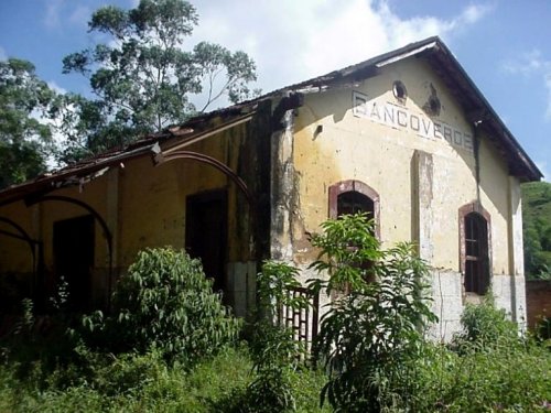
ca. 2003 (Photo : Wanderley Duck, in estacoesferroviarias.com.br)
Paula Sobrinho writes in História Postal de Minas Gerais (Belo Horizonte, 1997) that there was a station post office there since May 1885. This information is confirmed by the postal report (Relatorio Postal) for 1887. BMG-0205a is the first postmark, which was seen with dates from 1887 and 1888 and is also made known by R. Koester in Carimbologia III:
BMG-0205a (RK) 1887-1888
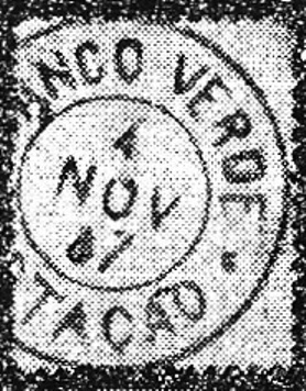
It was followed by BMG-0205b (image: Márcio Protzner) : a double circle with the inscriptions BANCO VERDE above and (EST.) below. The dates in the centre go from 1888 to 1901.
Instituto Brasileiro de Geografia e Estatística, 1958
Der Bahnhof Banco Verde (Grüne Bank) wurde im Dezember 1884 durch die E.F. Leopoldina Bahngesellschaft (Manhuassú-Linie) eingeweiht und lag im Município von Cataguazes, 260 km südöstlich der Provinzhauptstadt Ouro Preto entfernt. Die Bahnlinie wechselte 1975 zur Rede Ferroviária Federal S.A. und wurde 1979 stillgelegt. Heute sind die Schienen weg, und der Bahnhof ist eine Ruine (estacoesferroviarias.com.br). Seit Dezember 1890 liegt der Bahnhof im Município von S. Francisco do Capivara, der seit März 1891 Palma heißt.
ca. 2003 (Foto : Wanderley Duck, in estacoesferroviarias.com.br)
Paula Sobrinho schreibt in História Postal de Minas Gerais (Belo Horizonte, 1997), dass es dort seit Mai 1885 ein Bahnhofspostamt gab. Diese Angabe wird durch den Postbericht (Relatorio Postal) für 1887 bestätigt. BMG-0205a ist der erste Poststempel, der schon mit Daten aus 1887 und 1888 gesehen wurde und auch durch R. Koester in Carimbologia III bekannt ist:
BMG-0205a (RK) 1887-1888
Ihm folgte BMG-0205b (Abb. Márcio Protzner) : ein Doppelkreis mit den Inschriften BANCO VERDE oben und (EST.) unten. Daten in der Mitte von 1888 bis 1901.
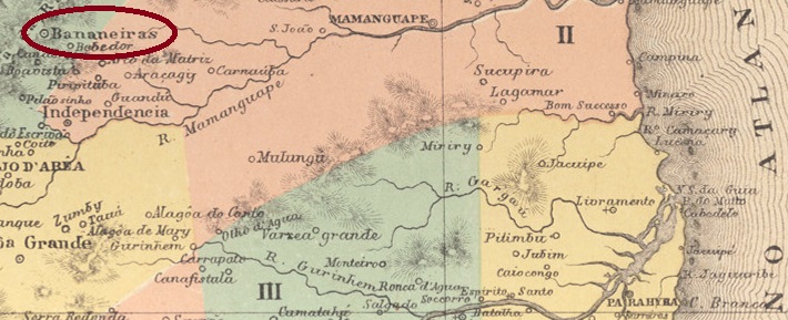
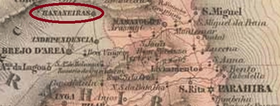
Bananeiras (Banana plants) was a settlement belonging to the vila of S. Miguel da Bahia da Traição, located 130 km northwest of the capital Parahyba do Norte (today: João Pessoa). In 1827, the local jurisdiction changed to the Vila of Areia and became a Vila in May 1833. Bananeiras has been a town since October 1879.
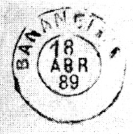
Nova Monteiro writes in Administrações e Agencias Postaes do Brasil Imperio (Brasil Filatelico/RJ, 1934-5; Reprint SPP 1994-1999) that there was a post office there since April 1835. This information is confirmed by the postal report (Relatorio Postal) for 1887. The only postmark of the imperial period so far is BPB-0045c, found with dates between 1884 and 1889 and already known by R. Koester in Carimbologia III:
BPB-0045c (RK) 1884-1889Villiers de l’Ile Adam: Carta (…) das Provincias do Rio Grande do Norte e Parahiba, 1848
Bananeiras (Bananenstauden) war eine Siedlung die zur Vila von S. Miguel da Bahia da Traição gehörte und 130 km nordwestlich der Hauptstadt Parahyba do Norte (heute: João Pessoa) lag. 1827 wechselte die Ortszuständigkeit zur Vila von Areia und wurde im Mai 1833 eine Vila. Seit Oktober 1879 ist Bananeiras eine Stadt.
Nova Monteiro schreibt in Administrações e Agencias Postaes do Brasil Imperio (Brasil Filatelico/RJ, 1934-5; Reprint SPP 1994-1999), dass es dort seit April 1835 ein Postamt existierte. Diese Angabe wird durch den Postbericht (Relatorio Postal) für 1887 bestätigt. Der bisher einzige Poststempel der Kaiserzeit ist BPB-0045c, der mit Daten zwischen 1884 und 1889 gefunden wurde und bereits durch R. Koester in Carimbologia III bekannt ist: