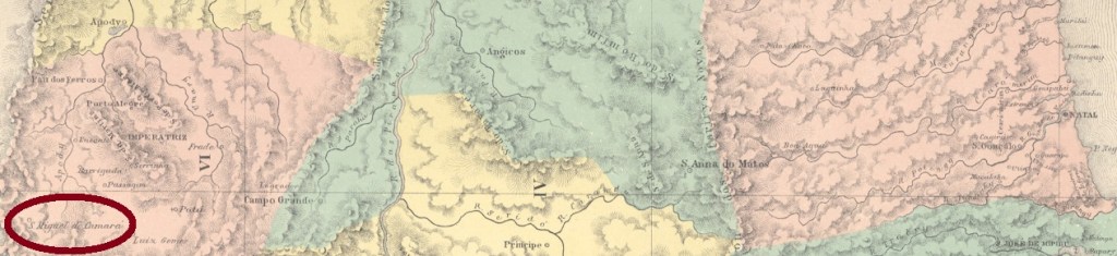
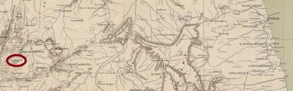
Other names: São Miguel do Camará, São Miguel de Pau dos Ferros
From September 1875, this was a district of Pau dos Ferros, located close to the border with the province of Ceará, about 440 km west of the provincial capital Natal. In December 1876 it became the villa of S. Miguel de Pau dos Ferros, which since April 1938 bears the simplified name of São Miguel.
Two founding years for the local post office were found. First in 1848, as can be read in the Imperial Mail Register (Tabella das Agencias do Correio do Imperio, Rio de Janeiro, 1885). Then in 1875, as can be read in the provincial president’s report of May of that year:
Relatório do Presidente da Provincia, May 1875
Until now, no cancel from the imperial era could be surely assigned to this village.
Serviço Geológico e Mineralógico do Brasil, 1910
Andere Namen: São Miguel do Camará, São Miguel de Pau dos Ferros
São Miguel war ab September 1875 ein Distrikt von Pau dos Ferros, der dicht an der Grenze zur Provinz Ceará lag, ca. 440 km westlich der Provinzhauptstadt Natal entfernt. Im Dezember 1876 wurde daraus die Villa von S. Miguel de Pau dos Ferros, die seit April 1938 den vereinfachten Namen São Miguel trägt.
Zwei Gründungsjahre fürs örtliche Postamt wurden gefunden. Erstmals in 1848, wie im Verzeichnis der kaiserlichen Postämter (Tabella das Agencias do Correio do Imperio, Rio de Janeiro, 1885) zu lesen ist. Dann 1875, wie aus dem Bericht des Provinzpräsidenten vom Mai des Jahres hervorgeht:
Relatório do Presidente da Provincia, Mai 1875
Bisher konnte kein Stempel aus der Kaiserzeit mit Sicherheit dieser Ortschaft zugeordnet werden.
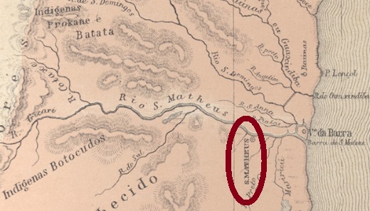
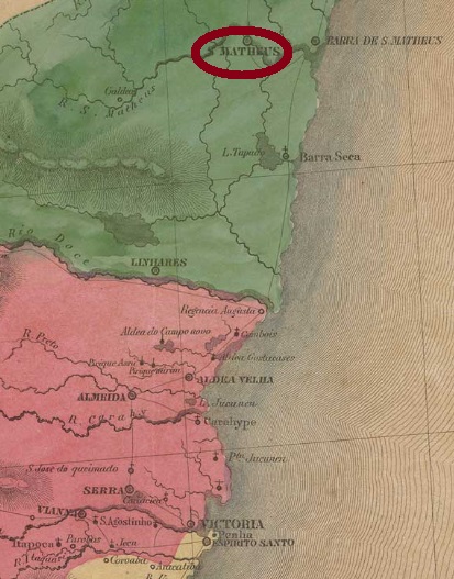
Other names: Cricaré, Vila Nova do Rio de São Mateus
This locality is said to be the second oldest village in the colonial Capitania of Espírito Santo – although at the beginning the region was still part of the Capitania of Porto Seguro – and was already in May 1755 a freguesia, which was located on the south bank of the river of the same name, about 240 km north of the future provincial capital Of Vitória. In September 1764, the village rose to a villa and in April 1764, to a city.
Two years of creation were found for the local post office. Nova Monteiro (Administrações e Agencias Postaes do Brasil Imperio, in Brasil Filatelico/RJ, 1934-5; Reprint SPP 1994-1999) writes October 1831, while Paulo Novaes (agenciaspostais.com.br) lists the agency from “approx. 1856”, which would be actually a reopening date.
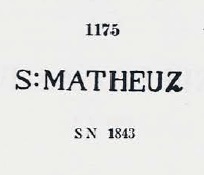
The first cancel is undoubtedly SES-0150a, which probably dates to the pre-philatelic period, was used at least until 1845, having been presented by Paulo Ayres (Catálogo de Carimbos Brasil-Império, S. Paulo, 1937, 1942) under No. 1175:
SES-0150a (P.A. 1175)
It was followed by SES-0150b (Coll. José A. Junges): a double circle with the inscription CORREIO DE SAO MATHEUS above and an ornament in diamond made of four small diamonds. The centre was free to enter the date by hand, but both sighted copies (on D. Pedro editions of 1866 and 1882) have no date.
The last imperial cancel is SES-0150c (Coll. Karlheinz Wittig). In the double circle, the inscription above is now S. MATHEUS, below there is nothing, and the dates inside go from 1883 to 1894. This cancel is also available in red, violet, blue and turquoise.
Villiers de l’Ile Adam: Carta (…) da Provincia do Espirito Santo, 1850
Andere Namen: Cricaré, Vila Nova do Rio de São Mateus
São Matheus ist angeblich die zweitälteste Ortschaft in der kolonialen Capitania von Espírito Santo – obwohl zu Beginn die Region noch zur Capitania von Porto Seguro gehörte–und war bereits im Mai 1755 eine Freguesia, die am Südufer des gleichnamigen Flusses lag, ca. 240 km nördlich der künftigen Provinzhauptstadt Vitória. Im September 1764 stieg der Ort zur Villa und im April 1764 zur Stadt auf.
Zwei Entstehungsdaten fürs örtliche Postamt wurden ermittelt. Nova Monteiro (Administrações e Agencias Postaes do Brasil Imperio, in Brasil Filatelico/RJ, 1934-5; Reprint SPP 1994-1999) schreibt dafür den Oktober 1831, während Paulo Novaes (agenciaspostais.com.br) listet die Agentur ab “ca. 1856” auf, was eigentlich ein Wiedereröffnungsdatum wäre.
Ihm folgte SES-0150b (Samml. José A. Junges): ein Doppelkreis mit der Inschrift CORREIO DE SAO MATHEUS oben und einem Ornament in Raute, das aus vier kleinen Rauten gebildet wird. Die Mitte war frei, um das Datum per Hand einzutragen, aber beide gesichteten Exemplare (auf D. Pedro-Ausgaben von 1866 und 1882) haben keine Datenangaben. Der letzte kaiserliche Stempel ist SES-0150c (Samml. Karlheinz Wittig). Im Doppelkreis lautet die Inschrift oben nun S. MATHEUS; unten ist leer, Daten im Inneren von 1883 bis 1894. Dieser Stempel kommt auch in rot, violett, blau und türkis vor.
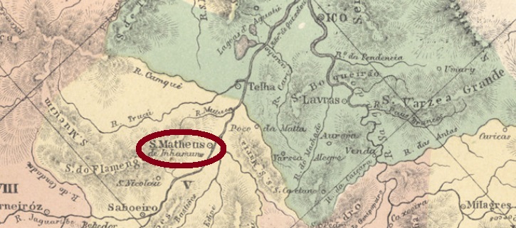
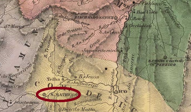
As early as the 18th century, this village was a freguesia of Icó, located on the north bank of the Jaguaribe River, about 400 km south of the future provincial capital Fortaleza. In February 1823 it became a villa, but in November 1851 the municipality lost its independence and became a district in the municipality of Saboeiro. In September 1893, the village rose again to Villa, and fifty years later the current toponym name Jucás was added.
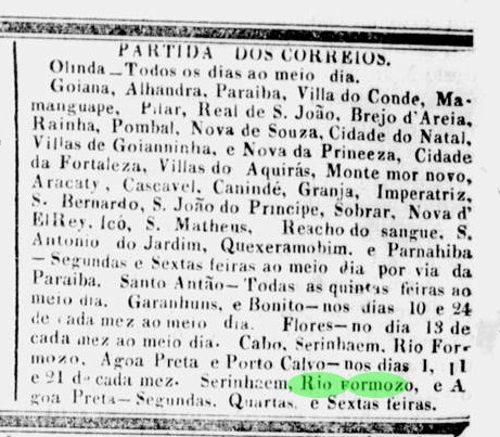
Two operating periods for the local post office were found, there could be a third in-between. The first period began before April 1836, when around this time a postal route from Recife in the province of Pernambuco to Parnahiba on the provincial border between Piauí and Maranhão passed through São Matheus in Ceará, as reported by the Pernambuco press:
Diário de Pernambuco, 7 April 1836
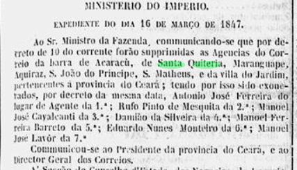
According to the official press in Rio, this first period came to an end in March 1847:
Gazeta Official/RJ, 24 March 1847
According to the Imperial Mail Register (Tabella das Agencias do Correio do Imperio, Rio de Janeiro, 1885), the agency reopened in 1877, but there are isolated indications in the regional press that hints in the meantime a post office could have been operating there. Until now, no postmark could be surely assigned to this village during the imperial period.
Villiers de l’Ile Adam: Carta (…) da Provincia do Ceará, 1849
Andere Namen: S. Matheus de Inhamuns, Jucás (1943)
Diese Ortschaft war bereits im 18. Jahrhundert eine Freguesia von Icó, die am Nordufer des Flusses Jaguaribe lag, rund 400 km südlich der künftigen Provinzhauptstadt Fortaleza entfernt. Im Februar 1823 wurde daraus eine Villa, aber im November 1851 verlor die Gemeinde ihre Selbständigkeit und wurde ein Distrikt im Município von Saboeiro. Im September 1893 stieg der Ort abermals zu Villa, und fünfzig Jahre später kam der aktuelle Ortsname Jucás dazu.
Zwei Betriebsperioden fürs örtliche Postamt wurden gefunden, es könnte eine dritte dazwischen sein. Die erste Periode fing bereits vor April 1836 an, da um diese Zeit eine Postroute von Recife in der Provinz Pernambuco bis Parnahiba an der Provinzgrenze zwischen Piauí und Maranhão durch São Matheus in Ceará ging, wie die Presse aus Pernambuco berichtet:
Diário de Pernambuco, 7. April 1836
Laut Amtspresse in Rio ging diese erste Periode im März 1847 zu Ende:
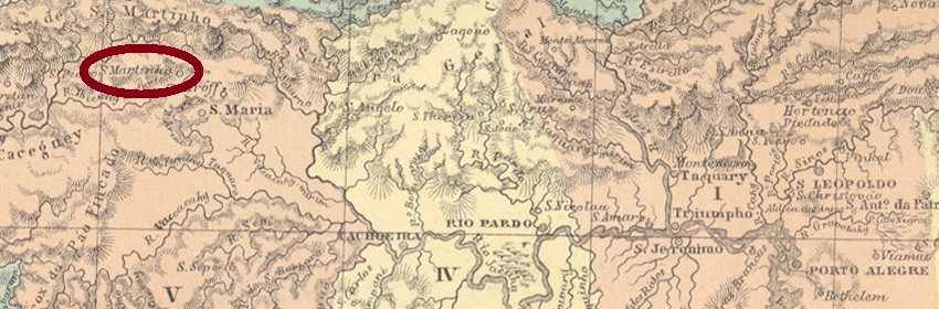
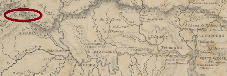
From the middle of the 19th century, this village was a freguesia of Cruz Alta, which was located close to the west bank of the Ibucuhy-Mirim River, about 320 km west of the provincial capital Porto Alegre. In May 1876, it was elevated to villa, but in 1901 the descent followed as a district of Santa Maria. It was not until March 1992 that political emancipation was regained, this time under the toponym of São Martinho da Serra.
According to Nova Monteiro, there has been a post office there since September 1866. This sounds rather improbable, because it was only ten years later that São Marinho became a villa. Furthermore, there was no news in the press, and the oldest available cancels have later dates. SRS-0230a (Coll. José A. Junges) is also available in purple and has a double circle with the inscription S. MARTINHO above. Dates in the middle from 1879 to 1884. SRS-0230b (Coll. José A. Junges) has the same inscription in larger letters above, but now there is also an ornament in cross below, which consists of four converging arrowheads. It also occurs in red and has internal dates from 1885 to 1887.
Provincia de São Pedro do Rio Grande do Sul, 1877
Anderer Name: São Martinho da Serra
Diese Ortschaft war ab Mitte des 19. Jahrhunderts eine Freguesia von Cruz Alta, die nah am Westufer des Flusses Ibucuhy-Mirim lag, ca. 320 km westlich der Provinzhauptstadt Porto Alegre entfernt. Im Mai 1876 wurde der Ort zu Villa erhoben, aber 1901 folgte der Abstieg als Distrikt von Santa Maria. Erst im März 1992 konnte die politische Emanzipation wieder erlangt werden, diesmal unter dem Ortsnamen São Martinho da Serra.
Laut Nova Monteiro gibt es dort ein Postamt seit September 1866. Das klingt eher unwahrscheinlich, denn erst zehn Jahre später wurde São Marinho eine Villa. Dann war keine diesbezügliche Nachricht in der Presse zu finden, und die ersten Stempel haben spätere Daten. SRS-0230a (Samml. José A. Junges) kommt auch in violett vor und ist ein Doppelkreis mit der Inschrift S. MARTINHO oben. Daten in der Mitte von 1879 bis 1884. SRS-0230b (Samml. José A. Junges) hat die gleiche Inschrift in größeren Buchstaben oben, aber nun gibt es auch ein Ornament in Kreuz unten, das aus vier konvergierenden Pfeilspitzen besteht. Es kommt auch in rot vor und hat interne Daten von 1885 bis 1887.
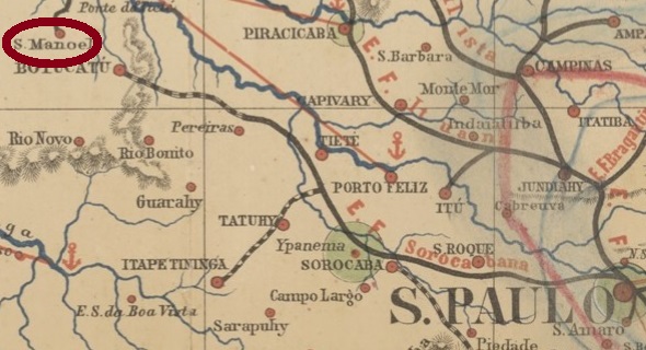
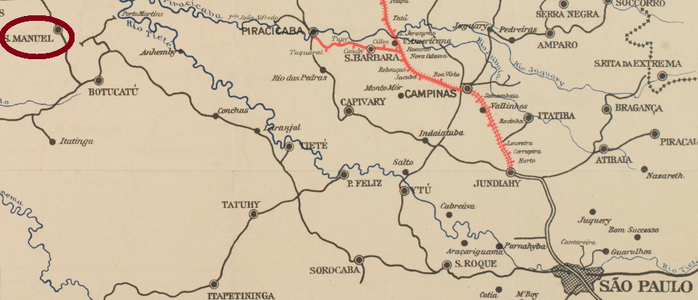
From April 1880, the town was a freguesia of Botucatu, less than 260 km west of the provincial capital of Sao Paulo. In March 1885, the village rose to a villa, and in May 1899 to a town.
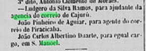
The local post office was established until November 1879, as the regional press reports:
Jornal da Tarde, 1 November 1879.
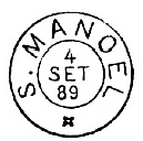
Two postmarks of the imperial period are known. SSP-1200a (Coll. Mário Celso Orsi Jr.) is a French type: a double circle with the inscription S. MANOEL above and the typical star between brackets below. The only specimen to date bears a date from 1885 inside. SSP-1200b has already been introduced by Paulo Ayres in Catalogo de Carimbos Brasil-Império (S. Paulo, 1937, 1942) on page 126:
SSP-1200b (P. Ayres p. 126) 1888-1894Cia. Paulista
Anderer Name: S. Manoel do Paraíso
São Manoel do Paraíso, oder einfach S. Manoel, war ab April 1880 eine Freguesia von Botucatu, die knapp 260 km westlich der Provinzhauptstadt São Paulo entfernt lag. Im März 1885 stieg der Ort zur Villa, und im Mai 1899 zur Stadt auf.
Das örtliche Postamt entstand bis November 1879, wie die Regionalpresse zu berichten weiß:
Jornal da Tarde, 1. November 1879.
Zwei Poststempel der Kaiserzeit sind bekannt. SSP-1200a (Samml. Mário Celso Orsi Jr.) ist ein französischer Typ: ein Doppelkreis mit der Inschrift S. MANOEL oben und dem typischen Stern zwischen Klammern unten. Das bisher einzige Exemplar trägt ein Datum aus 1885 in der Mitte. SSP-1200b wurde bereits durch Paulo Ayres in Catálogo de Carimbos Brasil-Império (S. Paulo, 1937, 1942) auf Seite 126 vorgestellt:
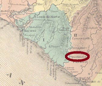
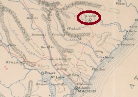
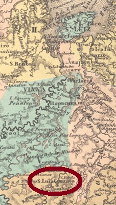
São Luiz do Quitunde was from June 1882 a district of Passos do Camaragibe, which was located on the west bank of the Periperi River, about 50 km north of the provincial capital Maceió. In June 1879 it became a villa, and in May 1892 a town.
Both Aldo Cardoso (Contribuição para a História dos Correios de Alagoas, Maceió, 1969) and the Imperial Mail Register (Tabella das Agencias do Correio do Imperio, Rio de Janeiro, 1885) agree that there has been a post office there since February 1873. The only cancel of the imperial period so far is SAL-0215a (Coll. José A. Junges): a double circle with the inscription S. LUIZ DE QUITUNDE above. The dates at the centre have been found so far for the period 1890-1892.
Carta Corographica do Estado do Alagoas, 1893
São Luiz do Quitunde war ab Juni 1882 ein Distrikt von Passos do Camaragibe, der am Westufer des Flusses Periperi lag, gut 50 km nördlich der Provinzhauptstadt Maceió entfernt. Im Juni 1879 wurde daraus eine Villa, und im Mai 1892 eine Stadt.
Carta da Republica dos Estados Unidos do Brazil, 1892
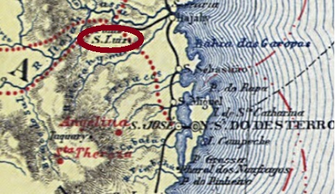
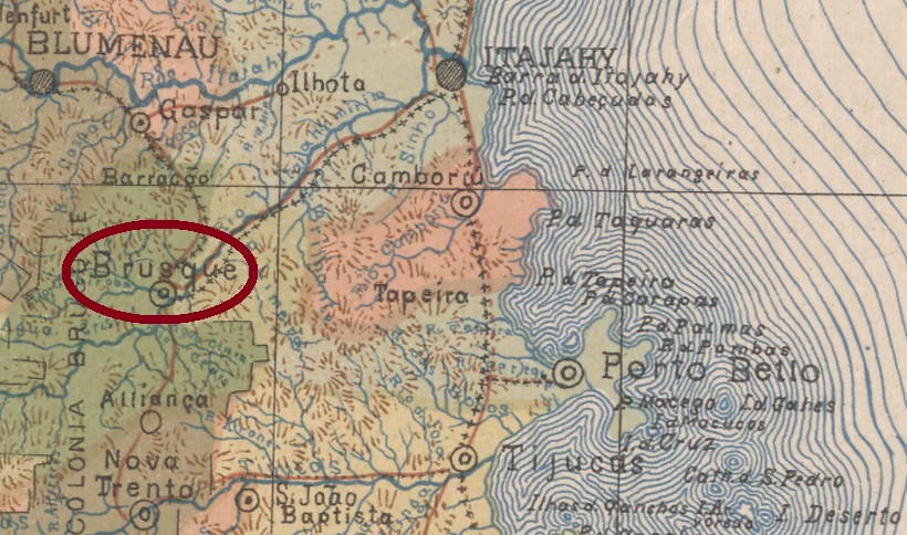
Another name: Brusque (1890)
From July 1873, this village was a district of Itajahy, located about 100 km northwest of the provincial capital Desterro (now Florianopolis) and was elevated to villa in March 1881. It was renamed Brusque in January 1890, in memory of Francisco Carlos de Araújo Brusque (1822-1886), who was the provincial president of Santa Catarina from 1859 to 1861. Brusque has been a town since September 1916.
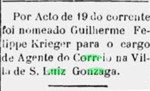
So far, the exact date for the creation of the postal agency has not been found. However, this took place between 1885 and 1887, since the earliest recorded introduction of a postal clerk was found in the regional press in October 1887:
Conservador, 21 October 1887
The imperial postmark is SSC-0230a (Coll. José A. Junges), a double circle with the inscriptions S. LUIZ GONZAGA above and (SA. CATHARINA) below. The dates inside were found for 1888 and 1889.
Mappa de Santa Catharina, 1907
Anderer Name: Brusque (1890)
Diese Ortschaft war ab Juli 1873 ein Distrikt von Itajahy, der ca. 100 km nordwestlich der Provinzhauptstadt Desterro (heute Florianópolis) entfernt lag und im März 1881 zur Villa erhoben wurde. Diese wurde im Januar 1890 zu Brusque umbenannt, im Andenken an Francisco Carlos de Araújo Brusque (1822-1886) der Provinzpräsident in Santa Catarina von 1859 bis 1861 war. Seit September 1916 ist Brusque eine Stadt.
Bisher wurde der genaue Termin für die Entstehung der Postagentur nicht gefunden. Dieser musste aber zwischen 1885 und 1887 liegen, da der früheste Postangestellter im Oktober 1887 durch die Regionalpresse vorgestellt wurde:
Conservador, 21. Oktober 1887
Der kaiserliche Poststempel ist SSC-0230a (Samml. José A. Junges), ein Doppelkreis mit den Inschriften S. LUIZ GONZAGA oben und (SA. CATHARINA) unten. Die Daten in Inneren wurden für 1888 und 1889 gefunden.
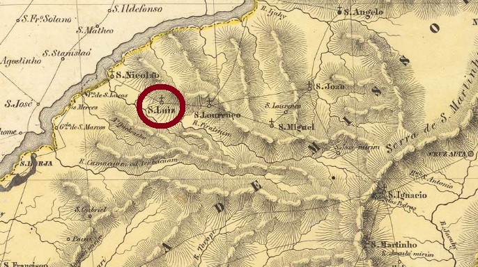
From January 1858, São Luiz Gonzaga was a district of São Borja, in the province of São Pedro do Rio Grande, located 500 km northwest of the capital, Porto Alegre. In June 1880 it rose to villa and in March 1902 to a town.
As can be read in the Imperial Mail Register (Tabella das Agencias do Correio do Imperio) from 1885, there is a post office there since 1880. The imperial stamp there has not yet been definitively confirmed, but it must be this SRS-0355a (coll. José A. Junges), a double circular one with the inscription S. LUIZ above and a rhombus ornament below, formed by four small rhombuses.
Villiers de l’Ile Adam: Carta (…) da Provincia de São Pedro do Sul, 1847
Andere Namen: São Luiz, S. Luiz das Missões
São Luiz Gonzaga in der Provinz São Pedro do Rio Grande war ab Januar 1858 ein Distrikt von São Borja, der 500 km nordwestlich der Hauptstadt Porto Alegre entfernt lag. Im Juni 1880 stieg der Ort zur Villa und im März 1902 zur Stadt auf.
Wie imVerzeichnis der kaiserlichen Postämter (Tabella das Agencias do Correio do Imperio) von 1885 zu lesen ist, gibt es dort ein Postamt seit 1880. Der dortige kaiserliche Stempel ist noch nicht endgültig bestätigt, aber es muss dieser SRS-0355a (Samml. José A. Junges) sein, ein doppelter Rundstempel mit der Inschrift S. LUIZ oben und einem Ornament in Raute unten, gebildet aus vier kleinen Rauten.
Other names: São Luiz Gonzaga do Alto Mearim, Ipixuna, São Luís Gonzaga do Maranhão (1971)
See also Alto Mearim (R. Koester, Carimbologia I)
São Luiz Gonzaga do Alto Mearim was a district of Itapecuru-Mirim from August 1844, on the east bank of the Mearim River, 250 km south of the provincial capital São Luis do Maranhão. In June 1854, the village was elevated to a villa. After that, the place name changed twice: in December 1943 to Ipixuna (“dark water” in tupi) and in October 1971 to the still current São Luís Gonzaga do Maranhão.
According to Nova Monteiro (Administrações e Agencias Postaes do Brasil Imperio, in Brasil Filatelico/RJ, 1934-5; Reprint SPP 1994-1999) there is a post office there since March 1859. However, until 1884 only town cancels with the inscription Alto Mearim can be seen. No cancel under S. Luiz Gonzaga was found; if there is one, he will be from the end of the Empire. For cancelswith Alto Mearim see Koester: Carimbologia I.
Villiers de l’Ile Adam: Carta (…) da Provincia do Maranhão, 1850
Andere Namen: São Luiz Gonzaga do Alto Mearim, Ipixuna, São Luís Gonzaga do Maranhão (1971)
Siehe auch Alto Mearim (R. Koester, Carimbologia I)
São Luiz Gonzaga do Alto Mearim war ab August 1844 ein Distrikt von Itapecuru-Mirim und lag am Ostufer des Flusses Mearim, 250 km südlich der Provinzhauptstadt São Luis do Maranhão entfernt. Im Juni 1854 wurde der Ort zur Villa erhoben. Danach wechselte der Ortsname zweimal: im Dezember 1943 zu Ipixuna („dunkles Wasser“ in der Tupi-Sprache) und im Oktober 1971 zum noch aktuellen São Luís Gonzaga do Maranhão.
Laut Nova Monteiro (Administrações e Agencias Postaes do Brasil Imperio, in Brasil Filatelico/RJ, 1934-5; Reprint SPP 1994-1999) gibt es dort ein Postamt seit März 1859. Allerdings sind bisher alle Ortsstempel bis 1884 mit der Inschrift Alto Mearim zu sehen. Kein Stempel unter S. Luiz Gonzaga wurde gefunden; sollte es einen geben, wird er aus dem Ende des Kaiserreichs sein. Für Stempel mit Alto Mearim siehe Koester: Carimbologia I.
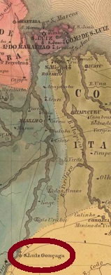
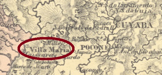
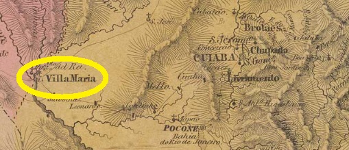
Other names: Villa Maria do Paraguay, Cáceres (1938)
Since the end of the 18th century, this village was the early freguesia of São Luiz de Villa Maria, located on the east bank of the Paraguay River, 220 km west of the later provincial capital Cuiabá (then written Cuyaba). In October 1859, the village rose to a villa, and in May 1874 it became a town called the São Luiz de Caceres. Since 1938, the simplified place name of Cáceres has been used.
There was a former post office for Villa Maria, which was located on the important postal route between Cuyabá and Villa Bella do Matto Grosso and was operated with the interruption of the war against Paraguay (1864-1870). After the renaming of the town in 1874, the new toponym was also added to the postmarks. SMT-0070a (Coll. José A. Junges) has a double circle with the inscriptions S. LUIZ DE CACERES above and (M. GROSSO) below and was used between ca. 1877 and 1904, as the data inside show.
Villiers de l’Ile Adam: Carta (…) da Provincia do Matto Grosso, 1850
Andere Namen: Villa Maria do Paraguay, Cáceres (1938)
Diese Ortschaft war seit dem Ende des 18. Jahrhunderts die frühe Freguesia von São Luiz de Villa Maria, die am Ostufer des Flusses Paraguay lag, 220 km westlich der späteren Provinzhauptstadt Cuiabá (damals Cuyabá geschrieben) entfernt. Im Oktober 1859 emanzipierte sich der Ort als Villa, und im Mai 1874 wurde daraus eine Stadt, die São Luiz de Caceres heißt. Seit 1938 gilt der vereinfachte Ortsname Cáceres.
Es gab ein früheres Postamt für Villa Maria, die an der wichtigen Postroute zwischen Cuyabá und Villa Bella do Matto Grosso lag und – mit der Unterbrechung des Kriegs gegen Paraguay (1864-1870) – wohl ständig betrieben wurde. Nach der Ortsumbenennung 1874 kam auch der neue Name auf die Poststempel. SMT-0070a (Samml. José A. Junges) hat einen Doppelkreis mit den Inschriften S. LUIZ DE CACERES oben und (M. GROSSO) unten und wurde zwischen ca. 1877 und 1904 gebraucht, wie die Daten im Inneren verlauten.