Categories
Carimbologia H-L

Livramento, Piauí (LPI-0090)

Atlas do Imperio do Brasil, 1868

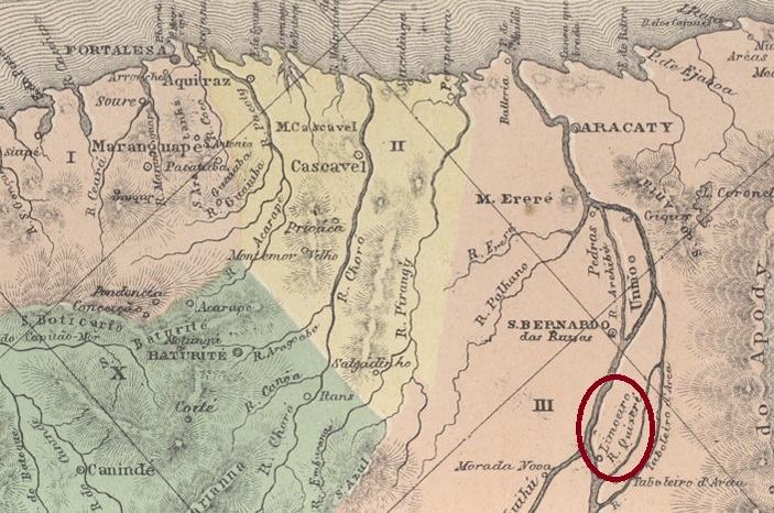
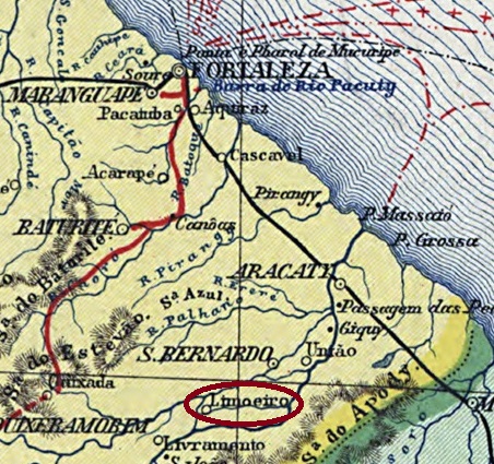
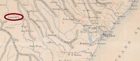
Other names: José de Freitas (1931)

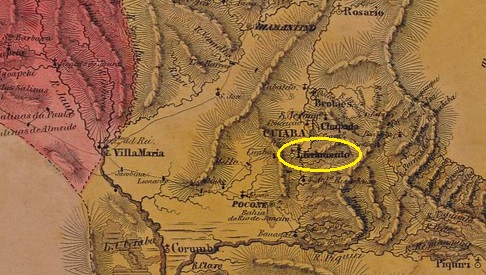
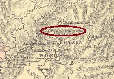
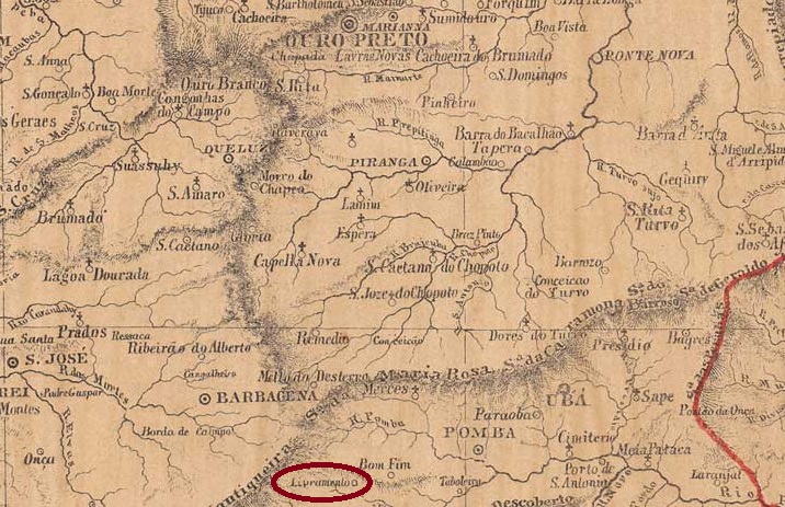
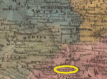
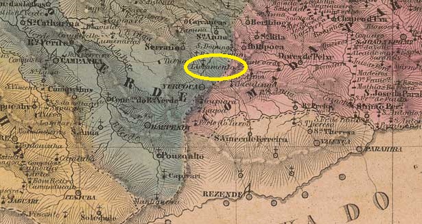
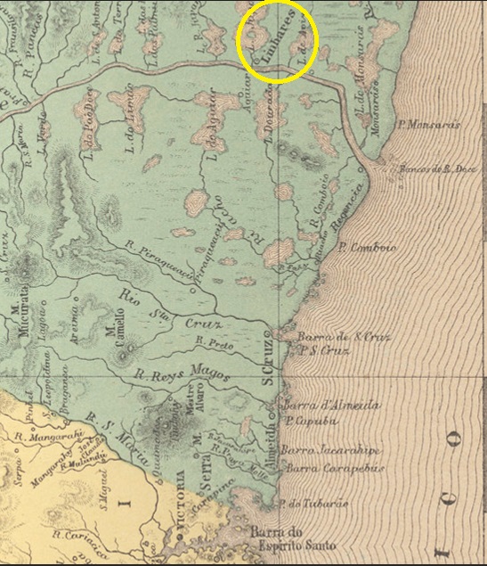
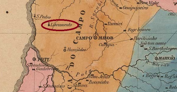
The Freguesia de Nossa Senhora do Livramento had existed since July 1874 and belonged to the Vila de União. It was located 55 kilometres north-east of the provincial capital Teresina. In May 1877, it became a Vila and was finally elevated to a city in July 1924. Since March 1931, the town has borne the name José de Freitas, in honour of a large landowner in the region from the late 19th century.

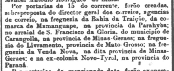
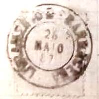
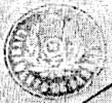
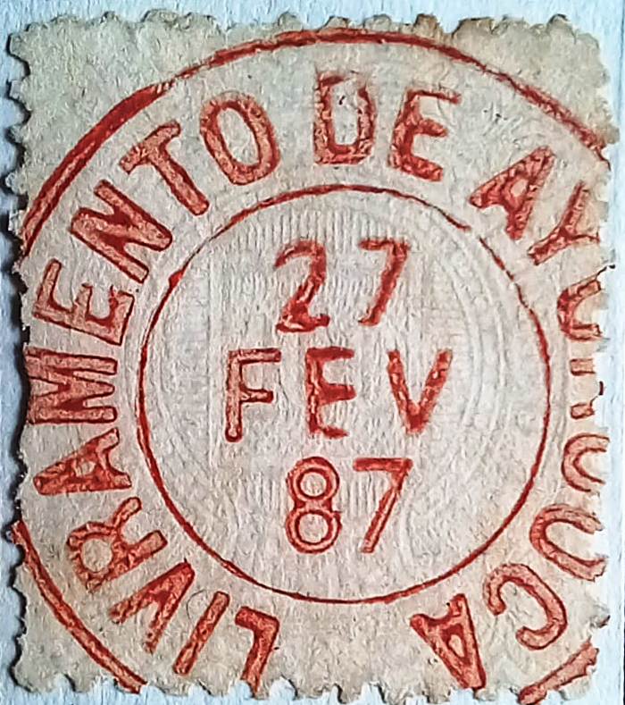
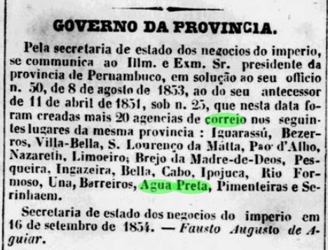
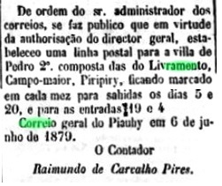
According to the list of imperial post offices (Tabella das Agencias do Correio do Imperio, Rio de Janeiro, 1885), there had been a post office there since 1879 and in June of the same year a postal route was established from Teresina, as reported in the regional press.

A Imprensa, 14 June 1879

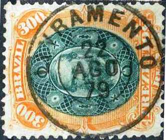
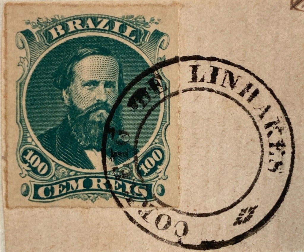
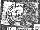
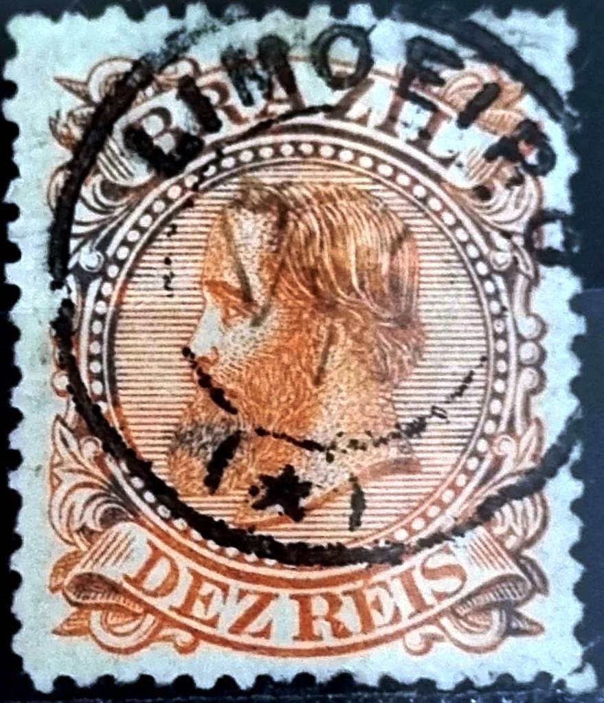
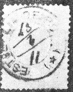
The only imperial postmark to date, LPI-0090a (illustration from the Internet), has yet to be definitively confirmed:

LPI-0090a (EB) 1879
Villiers de l’Ile Adam: Carta (…) da Provincia do Piauhy, 1850

Andere Namen: José de Freitas (1931)

Die Freguesia de Nossa Senhora do Livramento bestand seit Juli 1874 und gehörte zur Vila de União. Sie lag 55 Kilometer nordöstlich der Provinzhauptstadt Teresina. Im Mai 1877 wurde sie zur Vila und im Juli 1924 schließlich zur Stadt erhoben. Seit März 1931 trägt die Stadt den Namen José de Freitas, zu Ehren eines Großgrundbesitzers der Region aus dem späten 19. Jahrhundert.

Wie aus dem Verzeichnis der kaiserlichen Postämter (Tabella das Agencias do Correio do Imperio, Rio de Janeiro, 1885) hervorgeht, gab es dort seit 1879 ein Postamt und im Juni desselben Jahres wurde eine Postroute von Teresina dorthin eingerichtet, wie die regionale Presse bekannt gab.

A Imprensa, 14.06.1879

Der bisher einzige kaiserlicher Poststempel LPI-0090a (Abb. aus dem Internet) muss noch endgültig bestätigt werden:

LPI-0090a (EB) 1879
Categories
Carimbologia H-L

Livramento, Mato Grosso (LMT-0030)

Villiers de l’Ile Adam: Carta (…) da Provincia do Matto Grosso, 1850

Other names: S. José dos Cocais

The Freguesia de Nossa Senhora do Livramento had existed since August 1835 and belonged to the Vila de Cuiabá, which was located 40 kilometres to the north-east. In May 1883 it was elevated to the status of a Vila. In December 1943, the município changed its name to São José dos Cocais, but in October 1948 the name N. Sra. do Livramento returned.

As reported in the Rio de Janeiro press, it was decided in November 1882 to set up a local post office.

Jornal do Commercio/RJ, 17.11.1882

So far, no imperial postmark could be assigned to this locality with certainty.

Atlas do Imperio do Brasil, 1868

Andere Namen: S. José dos Cocais

Die Freguesia de Nossa Senhora do Livramento bestand seit August 1835 und gehörte zur Vila de Cuiabá, die 40 Kilometer weiter nordöstlich lag. Im Mai 1883 wurde sie zur Vila erhoben. Im Dezember 1943 änderte der Município seinen Namen zu São José dos Cocais, doch im Oktober 1948 kehrte der Name N. Sra. do Livramento zurück.

Wie die Presse aus Rio de Janeiro berichtete, wurde im November 1882 beschlossen, vor Ort ein Postamt einzurichten.

Jornal do Commercio/RJ, 17.11.1882

Bisher konnte kein kaiserlicher Poststempel mit Sicherheit dieser Ortschaft zugeordnet werden.

Categories
Carimbologia H-L

Livramento de Barbacena, Minas Gerais (LMG-1515)

Provincia de Minas Geraes, 1873

Other names: Oliveira Fortes (1943)

From 1836, Livramento was a district of Vila de Barbacena, 180 kilometres south of the provincial capital Ouro Preto. In May 1854, the town changed its name to Sant’Anna do Livramento and became a freguesia in November 1880. The place name Livramento returned in December 1938. Five years later, the district was renamed Oliveira Fortes. Oliveira Fortes has been an independent município since December 1953. The name commemorates one of the first large landowners in the region.

Paula Sobrinho (História Postal de Minas Gerais, Belo Horizonte, 1997) and R. Koester (Carimbologia XXVI) agree that there has been a post office there since April 1877. However, the directory of imperial post offices (Tabella das Agencias do Correio do Imperio, Rio de Janeiro, 1885) lists the agency as having been established in 1881. As the post office is not listed in the postal guide (Guia Postal do Império, Rio de Janeiro, 1880), it can be assumed that it was closed in the meantime.

The oldest postmark to date is LMG-1515a (collect. Fuad Ferreira Fo.)

LMG-1515a (FF) 1887

Koester (op. cit.) also shows the postmark with the imperial seal LMG-1515b:

LMG-1515b (RK)
Villiers de l’Ile Adam: Carta (…) da Provincia de Minas Geraes, 1849

Andere Namen: Oliveira Fortes (1943)

Seit 1836 war Livramento ein Distrikt der 180 km südlich der Provinzhauptstadt Ouro Preto gelegenen Vila de Barbacena. Im Mai 1854 änderte der Ort seinen Namen in Sant’Anna do Livramento und wurde im November 1880 zu einer Freguesia. Im Dezember 1938 kehrte der Ortsname Livramento zurück. Fünf Jahre später wurde der Distrikt zu Oliveira Fortes umbenannt. Seit Dezember 1953 ist Oliveira Fortes ein eigenständiger Município. Der Name erinnert an einen der ersten Großgrundbesitzer der Region.

Paula Sobrinho (História Postal de Minas Gerais, Belo Horizonte, 1997) und R. Koester (Carimbologia XXVI) sind sich einig, dass es dort seit April 1877 ein Postamt gab. Allerdings listet das Verzeichnis der kaiserlichen Postämter (Tabella das Agencias do Correio do Imperio, Rio de Janeiro, 1885) die Agentur mit dem Entstehungsjahr 1881 auf. Da das Postamt im Postführer (Guia Postal do Império, Rio de Janeiro, 1880) nicht aufgeführt wird, kann davon ausgegangen werden, dass es zwischendurch geschlossen war.

Der bisher älteste Poststempel ist LMG-1515a (Samml. Fuad Ferreira Fo.)

LMG-1515a (FF) 1887

Koester (op. cit.) zeigt auch den Stempel mit dem kaiserlichen Siegel LMG-1515b:

LMG-1515b (RK)
Categories
Carimbologia H-L

Livramento de Ayuruoca, Minas Gerais (LMG-1510)

Villiers de l’Ile Adam: Carta (…) da Provincia de Minas Geraes, 1849

Other names: Liberdade (1923)

From 1836, Livramento was a district of Ayuruoca, located on the north bank of the Rio Grande, 300 kilometres south of the provincial capital Ouro Preto. In May 1855, the town was elevated to the Freguesia de Senhor Bom Jesus do Livramento and changed its name to Liberdade (Liberty) in September 1923. Liberdade has been an independent município since December 1938.

Paula Sobrinho (História Postal de Minas Gerais, Belo Horizonte, 1997) and R. Koester (Carimbologia XXVI) agree that there has been a post office there since August 1872. The only imperial postmark to date is LMG-1510a (collect. Fuad Ferreira Fo.), which also occurs in red:

LMG-1510a (FF) 1886-1887
Atlas do Imperio do Brasil, 1868

Andere Namen: Liberdade (1923)

Seit 1836 war Livramento ein Distrikt von Ayuruoca, der am Nordufer des Rio Grande lag, 300 Kilometer südlich der Provinzhauptstadt Ouro Preto. Im Mai 1855 wurde der Ort zur Freguesia de Senhor Bom Jesus do Livramento erhoben und änderte im September 1923 seinen Namen in Liberdade (Freiheit). Seit Dezember 1938 ist Liberdade ein eigenständiger Município.

Paula Sobrinho (História Postal de Minas Gerais, Belo Horizonte, 1997) und R. Koester (Carimbologia XXVI) sind sich einig, dass es dort seit August 1872 ein Postamt gab. Der bisher einzige kaiserliche Poststempel ist LMG-1510a (Samml. Fuad Ferreira Fo.), der auch in Rot vorkommt:

LMG-1510a (FF) 1886-1887

Categories
Carimbologia H-L

Linhares, Espírito Santo (LES-0105)

Villiers de l’Ile Adam: Carta (…) da Provincia do Espirito Santo, 1850

Other names: Aldeia dos Coutins

The settlement on the north bank of the Rio Doce, 140 kilometres north of the later provincial capital Vitória, had existed since 1809 and was named after the Count of Linhares, the Portuguese Rodrigo de Sousa Coutinho (1755-1812), who organised the flight of the Lisbon court to Brazil (1807-1808).

The Count of Linhares (Wikipedia)

In August 1818, the village became the Freguesia de N. Sra. da Conceição de Linhares do Rio Doce and in April 1833 the Vila de Linhares. In December 1921, Linhares was downgraded to a district of the municipality of Colatina, but regained its municipality status in December 1943.

Linhares post office, 1975 (IBGE)

Nova Monteiro writes in Administrações e Agencias Postaes do Brasil Imperio (Brasil Filatelico/RJ, 1934-1935; reprint SPP 1994-1999) that there had been a post office there since October 1831. On agenciaspostais.com.br, however, P. Novaes writes December 1831, which could be a transcription error.

The oldest postmark to date is probably not the first: LES-0105b (fig. Roberto Assef Jr.) does not appear until the 1860s:

LES-0105b (RA) 1866ff-1876ff

This was followed by LES-0105c (ill. R. Koester, in Carimbologia XXVI):

LES-0105c (RK) 1885
Atlas do Imperio do Brasil, 1868

Andere Namen: Aldeia dos Coutins

Die Siedlung am Nordufer des Rio Doce, 140 Kilometer nördlich der späteren Provinzhauptstadt Vitória, bestand seit 1809. Benannt wurde sie nach dem Grafen von Linhares, dem Portugiesen Rodrigo de Sousa Coutinho (1755–1812), der die Flucht des Lissaboner Hofs nach Brasilien (1807–1808) organisierte.

Der Graf von Linhares (Wikipedia)

Im August 1818 wurde der Ort zur Freguesia de N. Sra. da Conceição de Linhares do Rio Doce und im April 1833 zur Vila de Linhares. Im Dezember 1921 wurde Linhares zum Distrikt des Munizips Colatina herabgestuft, erlangte jedoch im Dezember 1943 den Munizip-Status wieder.

Postamt Linhares, 1975 (IBGE)

Nova Monteiro schreibt in Administrações e Agencias Postaes do Brasil Imperio (Brasil Filatelico/RJ, 1934–1935; Nachdruck SPP 1994–1999), dass es dort seit Oktober 1831 ein Postamt gab. Auf agenciaspostais.com.br schreibt P. Novaes hingegen Dezember 1831, was ein Übertragungsfehler sein könnte.

Der bisher älteste Poststempel ist wohl nicht der erste: LES-0105b (Abb. Roberto Assef Jr.) kommt erst ab den 1860er Jahren vor:

LES-0105b (RA) 1866ff-1876ff

Es folgte LES-0105c (Abb. R. Koester, in Carimbologia XXVI):

LES-0105c (RK) 1885
Categories
Carimbologia Q-R

Limoeiro, Pernambuco (LPE-0380)

Villiers de l’Ila Adam: Carta (…) das Provincias de Pernambuco, Alagoas e Sergipe, 1848

The freguesia of Vila de Olinda on the north bank of the Capibaribe, 80 kilometres west of the later provincial capital of Recife, had existed since June 1786. In July 1811, it was elevated to Vila de N. Sra. da Apresentação do Limoeiro and in May 1881 to a town.

Two dates have been found for the founding of the post office. In Administrações e Agencias Postaes do Brasil Imperio (Brasil Filatelico/RJ, 1934-5; reprint SPP 1994-1999), Nova Monteiro mentions June 1855, which could mean that the agency was opened, as the decision to create a local post office had already been taken in September of the previous year, as reported in the regional press:

Diario de Pernambuco, 07/10/1854

The oldest postmark to date is probably not the first. The French type LPE-0380b (Marcio Duarte collection) already bears dates from the 1880s:

LPE-0380b (MD) 1883-1889
Atlas do Imperio do Brasil, 1868

Seit Juni 1786 bestand die Freguesia der Vila de Olinda am Nordufer des Capibaribe, 80 km westlich der späteren Provinzhauptstadt Recife. Im Juli 1811 wurde sie zur Vila de N. Sra. da Apresentação do Limoeiro und im Mai 1881 zur Stadt erhoben.

Für die Gründung des Postamtes wurden zwei Daten gefunden. Nova Monteiro nennt in Administrações e Agencias Postaes do Brasil Imperio (Brasil Filatelico/RJ, 1934-5; Reprint SPP 1994-1999) den Juni 1855, was die Inbetriebnahme der Agentur bedeuten könnte, da bereits im September des Vorjahres der Beschluss gefasst wurde, vor Ort ein Postamt einzurichten, wie die regionale Presse berichtet:

Diario de Pernambuco, 07.10.1854

Der bisher älteste Poststempel ist vermutlich nicht der erste. Der französische Typ LPE-0380b (Sammlung Marcio Duarte) trägt bereits Daten aus den 1880er Jahren:

LPE-0380b (MD) 1883-1889
Categories
Carimbologia H-L

Limoeiro (train station/Bahnhof), Pernambuco (LPE-0795)

Carta Corographica da Provincia de Pernambuco, 1880

Other names: Barão de Suassuna (ca. 1941)

Limoeiro station was opened in May 1862 by the railway company E.F. do Recife ao S. Francisco on the south bank of the Ipojuca in the Município de Escada, 70 km southwest of the provincial capital Recife. The name (lemon tree) comes from a sugar cane processing plant (Engenho) in the region. The railway line went to Great Western in 1901, to Rede Ferroviária do Nordeste in 1950 and belonged to Rede Ferroviária Federal S.A. (estacoesferroviarias.com.br) from 1975 until its closure in 1996. The tracks are still there today, but the station building has been demolished.

In November 2019 (Photo: Sydney Correa, on estacoesferroviarias.com.br)

Around 1941, the station was renamed Barão de Suassuna in memory of the owner of the Engenho Limoeiro, Henrique Marques de Hollanda Cavalcanti (1854-1941).

The 2nd Barão de Suassuna (on parentesco.com.br)

As can be seen from the list of imperial post offices (Tabella das Agencias do Correio do Imperio, Rio de Janeiro, 1885), there had been a post office at the station since 1875. The only imperial postmark to date is the French type LPE-0795a (fig. R. Koester, in Carimbologia XXVI):

LPE-0795a (RK) 1887
IBGE, 1958

Andere Namen: Barão de Suassuna (ca. 1941)

Der Bahnhof Limoeiro wurde im Mai 1862 von der Eisenbahngesellschaft E.F. do Recife ao S. Francisco am Südufer des Ipojuca im Município de Escada, 70 km südwestlich der Provinzhauptstadt Recife, eröffnet. Der Name (Zitronenbaum) stammt von einer Zuckerrohrverarbeitungsanlage (Engenho) in der Region. Die Bahnlinie ging 1901 an die Great Western, 1950 an die Rede Ferroviária do Nordeste und gehörte von 1975 bis zu ihrer Stilllegung 1996 der Rede Ferroviária Federal S.A. (estacoesferroviarias.com.br). Heute sind die Gleise noch vorhanden, das Bahnhofsgebäude wurde abgerissen.

Im November 2019 (Foto: Sydney Correa, auf estacoesferroviarias.com.br)

Um 1941 wurde der Bahnhof in Barão de Suassuna umbenannt, in Erinnerung an den Besitzer des Engenho Limoeiro, Henrique Marques de Hollanda Cavalcanti (1854-1941).

Der 2. Barão de Suassuna (auf parentesco.com.br)

Wie aus demVerzeichnis der kaiserlichen Postämter (Tabella das Agencias do Correio do Imperio, Rio de Janeiro, 1885) gab es am Bahnhof ein Postamt seit 1875. Der bisher einzige kaiserliche Poststempel ist der französische Typ LPE-0795a (Abb. R. Koester, in Carimbologia XXVI):

LPE-0795a (RK) 1887
Categories
Carimbologia H-L

Limoeiro, Espírito Santo (LES-0100)

Carta da Republica dos Estados Unidos do Brazil, 1892

Other names: Limoeiro de Sto. Antonio (ca. 1963)

Founded late by European immigrants, the settlement belonged to the Vila de Cachoeiro de Sta. Leopoldina as a district from April 1884 and was located on the Santo Antonio River, 110 km north-west of the provincial capital Vitória. The administrative jurisdiction then changed several times: in November 1890 to the Vila de Affonso Claudio, in November 1914 to the Município de Boa Família and in December 1921 to the Município de Itaguassú. Since December 1963, the village has been called Comunidade de Limoeiro de Sto. Antonio and now belongs to the Município de Itarana.

As Paulo Novaes writes in agenciaspostais.com.br, there had been a post office there since February 1887. This is confirmed by the postal report of that year:

Relatorio Postal 1887

Novaes writes that the agency was closed for the first time in October 1892. No imperial postmarks are known to date from Limoeiro in the province of Espírito Santo.

Google Maps

Andere Namen: Limoeiro de Sto. Antonio (ca. 1963)

Die erst spät von europäischen Einwanderern gegründete Siedlung gehörte ab April 1884 als Distrikt zur Vila de Cachoeiro de Sta. Leopoldina und lag am Fluss Santo Antonio, 110 km nordwestlich der Provinzhauptstadt Vitória. Danach wechselte die Verwaltungszuständigkeit mehrmals: im November 1890 zur Vila de Affonso Claudio, im November 1914 zum Município de Boa Família und im Dezember 1921 zum Município de Itaguassú. Seit Dezember 1963 heißt der Ort Comunidade de Limoeiro de Sto. Antonio und gehört nun zum Município de Itarana.

Wie Paulo Novaes in agenciaspostais.com.br schreibt, gab es dort seit Februar 1887 ein Postamt. Dies wird durch den Postbericht des Jahres bestätigt:

Relatorio Postal 1887

Novaes schreibt, dass die Agentur zum ersten Mal im Oktober 1892 geschlossen wurde. Aus Limoeiro in der Provinz Espírito Santo sind bisher keine kaiserlichen Poststempel bekannt.

Categories
Carimbologia H-L

Limoeiro, Ceará (LCE-0195)

Atlas do Imperio do Brasil, 1868

Other names: Limoeiro do Norte (1943)

The Freguesia de N. Sra. da Conceição do Limoeiro had existed since December 1864. It belonged to the Vila de S. Bernardo das Russas and was located on a large island in the Jaguaribe, 200 kilometres south of the provincial capital Fortaleza. Four years later it became a Vila and in August 1897 a town. Since December 1943, the município has been known as Limoeiro do Norte.

As can be seen from the list of imperial post offices (Tabella das Agencias do Correio do Imperio, Rio de Janeiro, 1885), there had been a post office there since 1873, of which R. Koester has shown in Carimbologia XXVI the only imperial postmark LCE-0195a that has been verified to date:

LCE-0195a (RK)
Carta da Republica dos Estados Unidos do Brasil, 1892

Andere Namen: Limoeiro do Norte (1943)

Die Freguesia de N. Sra. da Conceição do Limoeiro bestand seit Dezember 1864. Sie gehörte zur Vila de S. Bernardo das Russas und lag auf einer großen Insel des Jaguaribe, 200 km südlich der Provinzhauptstadt Fortaleza. Vier Jahre später wurde der Ort zur Vila und im August 1897 zur Stadt erhoben. Seit Dezember 1943 trägt der Município den Namen Limoeiro do Norte.

Wie aus dem Verzeichnis der kaiserlichen Postämter (Tabella das Agencias do Correio do Imperio, Rio de Janeiro, 1885) hervorgeht, gab es dort seit 1873 ein Postamt, von dem R. Koester in Carimbologia XXVI den bisher einzigen gesicherten Poststempel LCE-0195a gezeigt hat:

LCE-0195a (RK)
Categories
Carimbologia H-L

Limoeiro, Alagoas (LAL-0100)

Carta Corographica do Estado de Alagoas, 1893

Other names: Limoeiro de Anadia (1943)

The Freguesia de N. Sra. da Conceição do Limoeiro, which had existed since June 1865, belonged to the Vila de Anadia and was located on the north bank of the Coruripe, 110 kilometres west of the provincial capital Maceió. In May 1882 it was elevated to a Vila, and since December 1943 the Município has been called Limoeiro de Anadia, probably to avoid confusion with other Limoeiros in Brazil.

Aldo Cardoso writes in Contribuição para a História dos Correios de Alagoas (Maceió, 1969) that there had been a post office there since 1876. The oldest postmark to date is LAL-0100b (illustration by Aldo Cardoso):

LAL-0100b (AC) 1887-1890

LAL-0100c also appeared at the beginning of the Republic (illustration by Jorge L. Pedreira):

LAL-0100c (JLP) 1893
Arthur D. Ribeiro: Estado de Alagoas, 1923

Andere Namen: Limoeiro de Anadia (1943)

Die seit Juni 1865 bestehende Freguesia de N. Sra. da Conceição do Limoeiro gehörte zur Vila de Anadia und lag am Nordufer des Coruripe, 110 km westlich der Provinzhauptstadt Maceió. Im Mai 1882 wurde sie zur Vila erhoben, seit Dezember 1943 heißt der Município Limoeiro de Anadia, wohl um Verwechslungen mit anderen Limoeiros in Brasilien zu vermeiden.

Aldo Cardoso schreibt in Contribuição para a História dos Correios de Alagoas (Maceió, 1969), dass es dort seit 1876 ein Postamt gab. Der bisher älteste Poststempel ist LAL-0100b (Abb. Aldo Cardoso):

LAL-0100b (AC) 1887-1890

Am Anfang der Republik erschien auch LAL-0100c (Abb. Jorge L. Pedreira):

LAL-0100c (JLP) 1893