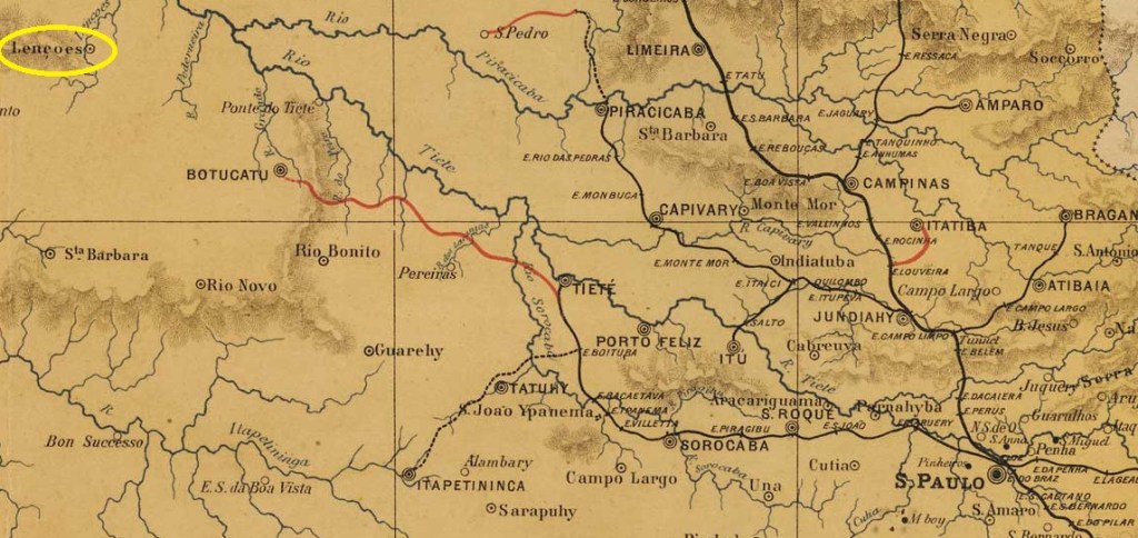
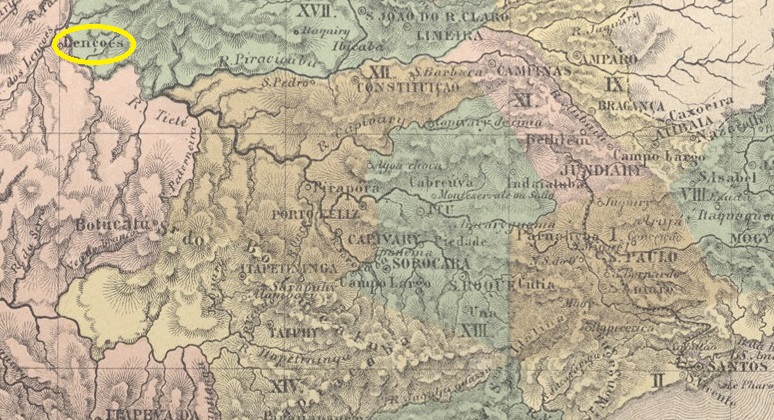
The Freguesia de N. Sra. da Piedade dos Lençóes, in existence since April 1858, belonged to the Vila de Botucatu and was located on the south bank of the Lençóis (a tributary of the Tietê), 280 kilometres northwest of the provincial capital of São Paulo. In April 1865 it became a Vila and in December 1895 a city, which has since changed its name twice: in November 1944 to Ubirama and in December 1948 to Lençóis Paulista.
As Nova Monteiro writes in Administrações e Agencias Postaes do Brasil Imperio (Brasil Filatelico/RJ, 1934-5; reprint SPP 1994-1999), there had been a post office there since April 1866. The oldest postmark to date is the French type LSP-0760b (collect. Fuad Ferreira Fo.):
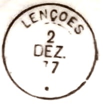
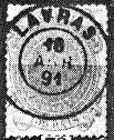
LSP-0760b (FF) 1876ff-1877
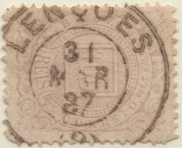
It was followed by LSP-0760c (coll. José A. Junges):
LSP-0760c (JJ) 1886-1888Atlas do Imperio do Brasil, 1868
Andere Namen: Ubirama, Lençóis Paulista (1948)
Die seit April 1858 bestehende Freguesia de N. Sra. da Piedade dos Lençóes gehörte zur Vila de Botucatu und lag am Südufer des Lençóis (einem Nebenfluss des Tietê), 280 km nordwestlich der Provinzhauptstadt São Paulo. Im April 1865 wurde es zur Vila und im Dezember 1895 zur Stadt erhoben, die seitdem zweimal ihren Namen geändert hat: im November 1944 in Ubirama und im Dezember 1948 in Lençóis Paulista.
Wie Nova Monteiro in Administrações e Agencias Postaes do Brasil Imperio (Brasil Filatelico/RJ, 1934-5; Reprint SPP 1994-1999) schreibt, gab es dort seit April 1866 ein Postamt. Der bisher älteste Poststempel ist der französische Typ LSP-0760b (Samml. Fuad Ferreira Fo.):
Other names: Lençóes do Roncador, Villa dos Lençóes, Lençóis
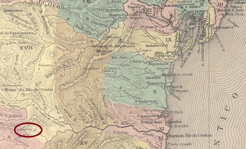
Lençóes had been since 1844 a settlement of the Vila de Minas do Rio de Contas on the south bank of the Riacho S. João (today: Rio Lençóis), 420 kilometres west of the provincial capital Salvador da Bahia. In 1847 it was transferred to the newly founded Vila de Sta. Isabel do Paraguaçu. Three name changes followed: in May 1852 to Distrito de Lençóes do Roncador, in December 1856 to Commercial Villa de Lençóes and in May 1864 to the town N. Sra. da Conceição dos Lençóes.
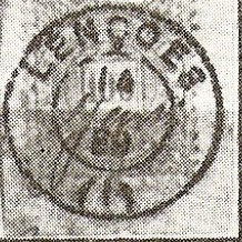
R. Koester writes in Carimbologia XXVI that there had been a post office there since November 1857. The only imperial postmark so far is LBA-0445b (fig. Koester, op.cit.):
LBA-0445b (RK) 1884-1889Villiers de l’Ile Adam: Carta (…) da Provincia da Bahia, 1848
Andere Namen: Lençóes do Roncador, Villa dos Lençóes, Lençóis
Lençóes war seit 1844 eine Siedlung der Vila de Minas do Rio de Contas am Südufer des Riacho S. João (heute: Rio Lençóis), 420 km westlich der Provinzhauptstadt Salvador da Bahia. 1847 wechselte sie zur neu gegründeten Vila de Sta. Isabel do Paraguaçu. Es folgten drei Namensänderungen: im Mai 1852 in Distrito de Lençóes do Roncador, im Dezember 1856 in Commercial Villa de Lençóes und im Mai 1864 in Stadt N. Sra. da Conceição dos Lençóes.
R. Koester schreibt in Carimbologia XXVI, dass es dort seit November 1857 ein Postamt gab. Der bisher einzige kaiserliche Poststempel ist LBA-0445b (Abb. Koester, op.cit.):
Estações (…) do Rio de Janeiro, São Paulo e Minas Geraes, 1880
Other names: Manuel Leme
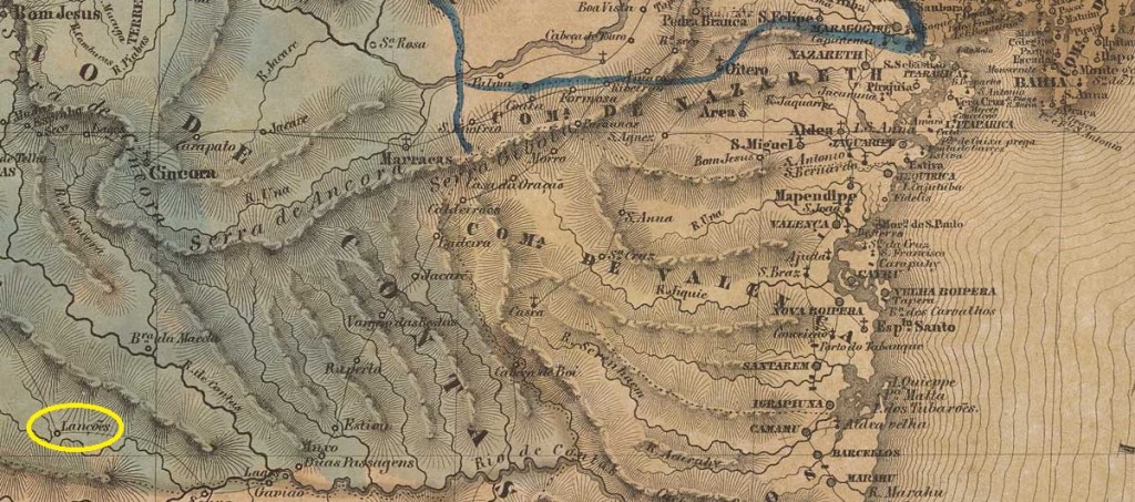
The Leme railway station was opened in September 1877 by the Companhia Paulista de Estradas de Ferro (Descalvado branch) and was in the Município de Pirassununga, 190 km north of the provincial capital of São Paulo. The line belonged to the FEPASA consortium from 1971 until its closure in 1997 (estacoesferroviarias.com.br). Today, the tracks have disappeared and the station building serves as a cultural centre for the community.
1910 (Photo: Heloísa Mansur, on estacoesferroviarias.com.br)In October 2020 (Photo: Silvio Rizzo, on estacoesferroviarias.com.br)
The area around the railway station was named Distrito in January 1891 and Vila de Leme in August 1895. Leme has been a town since December 1906. The name commemorates Manuel Leme, a former large landowner in the region.
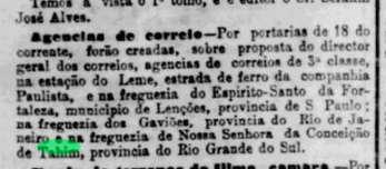
According to the Rio press, it was decided in June 1883 to set up a railway post office:
Jornal do Commercio/RJ, 19/06/1883
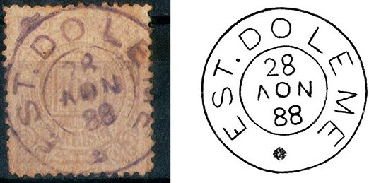
The imperial postmark is LSP-0755a (illus. Luiz C. Fritzen):
LSP-0755a (LCF) 1888Cia. Paulista de Estradas de Ferro
Andere Namen: Manuel Leme
Der Bahnhof Leme wurde im September 1877 von der Companhia Paulista de Estradas de Ferro (Descalvado-Zweig) eröffnet und lag im Município de Pirassununga, 190 km nördlich der Provinzhauptstadt São Paulo. Die Strecke gehörte von 1971 bis zu ihrer Stilllegung 1997 dem Konsortium FEPASA (estacoesferroviarias.com.br). Heute sind die Gleise verschwunden, das Bahnhofsgebäude dient der Gemeinde als Kulturzentrum.
1910 (Foto: Heloísa Mansur, auf estacoesferroviarias.com.br)Im Oktober 2020 (Foto: Silvio Rizzo, auf estacoesferroviarias.com.br)
Das Gebiet um den Bahnhof wurde im Januar 1891 zum Distrito und im August 1895 zur Vila de Leme ernannt. Seit Dezember 1906 ist Leme eine Stadt. Der Name erinnert an Manuel Leme, einen ehemaligen Großgrundbesitzer der Region.
Wie aus der Presse von Rio hervorgeht, wurde im Juni 1883 beschlossen, ein Bahnhofspostamt einzurichten:
Jornal do Commercio/RJ, 19.06.1883
Der kaiserliche Poststempel ist LSP-0755a (Abb. Luiz C. Fritzen):
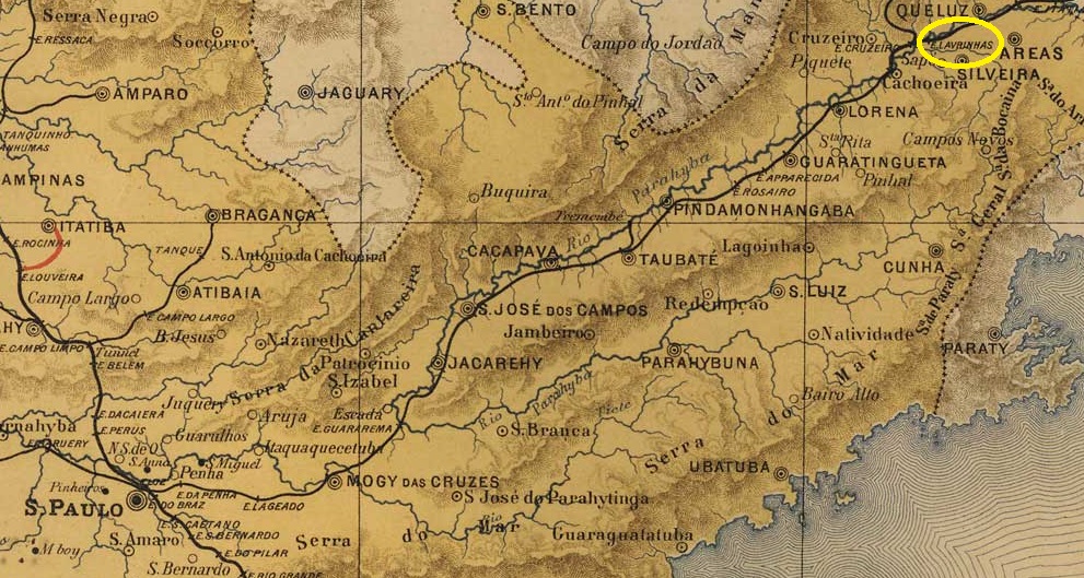
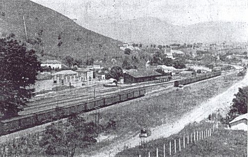
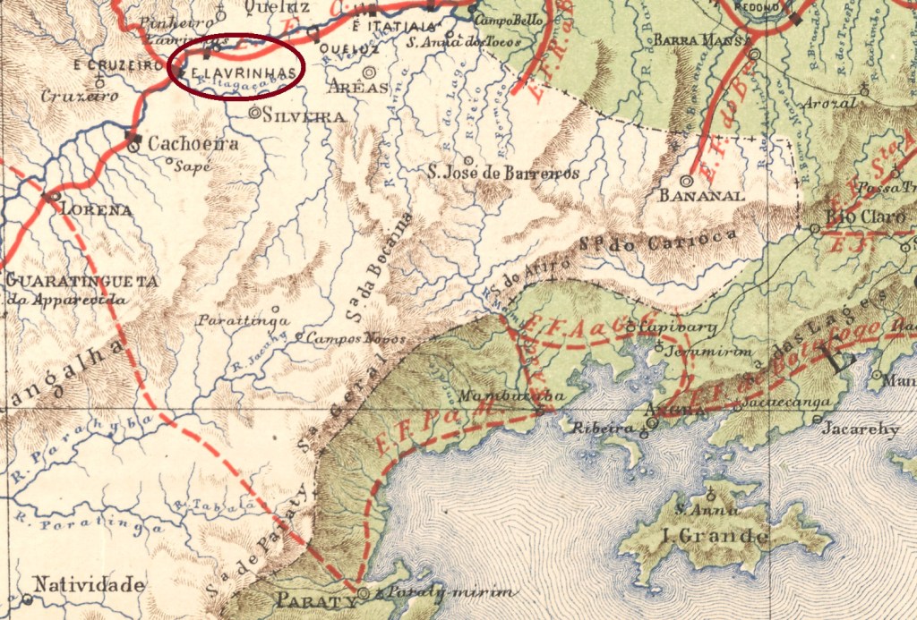
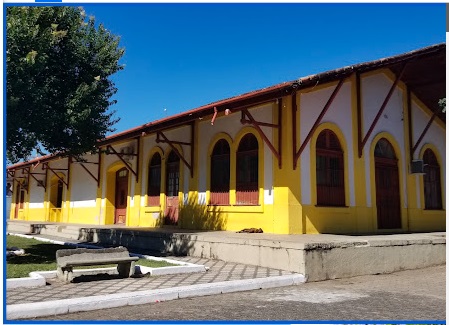
Lavrinhas station was opened in November 1874 by the railway company E.F. D. Pedro II (São Paulo branch) and was located on the east bank of the Paraíba do Sul in the Município de Queluz, 230 km north-east of the capital São Paulo. The line was put into operation by E.F. Central do Brasil in 1889 and belonged to Rede Ferroviária Federal S.A. from 1975 until its closure around 1980 (estacoesferroviarias.com.br). Today, the tracks have disappeared and the station building belongs to the Lavrinhas city council.
In 1961 (Photo: Marco Giffoni, on estacoesferroviarias.com.br)In August 2019: (Photo: Marcelo Pirani, on Google Maps)
The area around the railway station became the Distrito de Lavrinhas in the Município de Pinheiros in December 1917. Since November 1944, it has belonged to the Município de Lavrinhas.
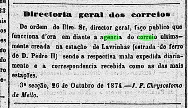
In October 1874, it was created a railway station post office, as can be seen in the Rio press:
Diario do Rio de Janeiro, 27/10/1874
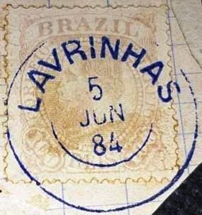
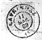
The oldest postmark is LSP-1645a (fig. Paulo Daroz):
LSP-1645a (PD) 1876ff
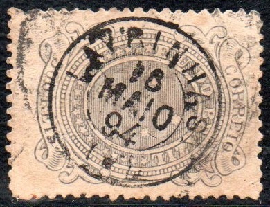
This was followed by the double circle LSP-1645b (fig. Felipe Piccinini), which also exists in blue:
LSP-1645b (FP) 1882ff-1892
The French type LSP-1645c (Fig. Felipe Piccinini) was also found around the same time:
LSP-1645c (FP) 1878ff-1894
Towards the end of the Empire, the rare LSP-1645d appeared (fig. R. Koester, in Carimbologia XXVI):
LSP-1645d (RK) 1889Estrada de Ferro Central do Brasil, 1890
Der Bahnhof Lavrinhas wurde im November 1874 von der Eisenbahngesellschaft E.F. D. Pedro II (Zweig São Paulo) eröffnet und lag am Ostufer des Paraíba do Sul im Município de Queluz, 230 km nordöstlich der Hauptstadt São Paulo. Die Strecke wurde 1889 von der E.F. Central do Brasil in Betrieb genommen und gehörte von 1975 bis zu ihrer Stilllegung um 1980 der Rede Ferroviária Federal S.A. (estacoesferroviarias.com.br). Heute sind die Gleise verschwunden, das Bahnhofsgebäude gehört der Stadtverwaltung von Lavrinhas.
1961 (Foto: Marco Giffoni, auf estacoesferroviarias.com.br)Im August 2019: (Foto: Marcelo Pirani, auf Google Maps)
Das Gebiet um den Bahnhof wurde im Dezember 1917 zum Distrito de Lavrinhas im Município de Pinheiros. Seit November 1944 gehört es zum Município de Lavrinhas.
Im Oktober 1874 wurde beschlossen, ein Bahnhofspostamt einzurichten, wie aus der Presse von Rio hervorgeht:
Diario do Rio de Janeiro, 27.10.1874
Der älteste Poststempel ist LSP-1645a (Abb. Paulo Daroz):
LSP-1645a (PD) 1876ff
Es folgte der Doppelkreis LSP-1645b (Abb. Felipe Piccinini), den es auch in Blau gibt:
LSP-1645b (FP) 1882ff-1892
Etwa zur gleichen Zeit fand sich auch der französische Typ LSP-1645c (Abb. Felipe Piccinini):
LSP-1645c (FP) 1878ff-1894
Gegen Ende des Kaiserreichs erschien der seltene LSP-1645d (Abb. R. Koester, in Carimbologia XXVI):
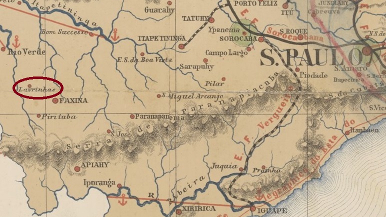
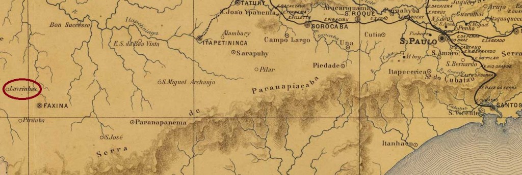
The settlement has been known since 1862 and belonged to the municipality of Villa de Faxina on the west bank of the Ribeirão das Lavrinhas, 320 kilometres west of the provincial capital of São Paulo. In March 1871, it was transferred as a freguesia to the Vila de S. João Baptista do Rio Verde, but returned to the parish of Faxina two years later and became the Vila de N. Sra. da Conceição de Lavrinhas in April 1891. In December 1895, this município was renamed Itaberá, which became a town in December 1906.
The list of imperial post offices (Tabella das Agencias do Correio do Imperio, Rio de Janeiro, 1885) shows that there had been a post office there since 1874. No imperial postmark of Lavrinhas near Faxina has yet been found.
J. M. Ribeiro Lisboa: Provincia de São Paulo, 1884
Andere Namen: Lavrinha, Itaberá (1895)
Die Siedlung ist seit 1862 bekannt und gehörte zur Gemeinde Villa de Faxina am Westufer des Ribeirão das Lavrinhas, 320 km westlich der Provinzhauptstadt São Paulo. Im März 1871 ging sie als Freguesia an die Vila de S. João Baptista do Rio Verde, kehrte aber zwei Jahre später zur Gemeinde Faxina zurück und wurde im April 1891 zur Vila de N. Sra. da Conceição de Lavrinhas. Im Dezember 1895 wurde dieses Município in Itaberá umbenannt, das seit Dezember 1906 eine Stadt ist.
Aus dem Verzeichnis der kaiserlichen Postämter (Tabella das Agencias do Correio do Imperio, Rio de Janeiro, 1885) geht hervor, dass es dort seit 1874 ein Postamt gab. Bisher wurde kein kaiserlicher Poststempel von Lavrinhas bei Faxina gefunden.
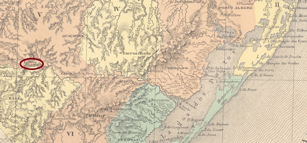
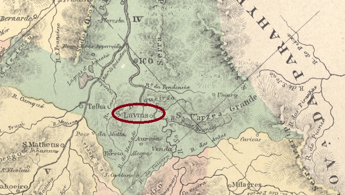
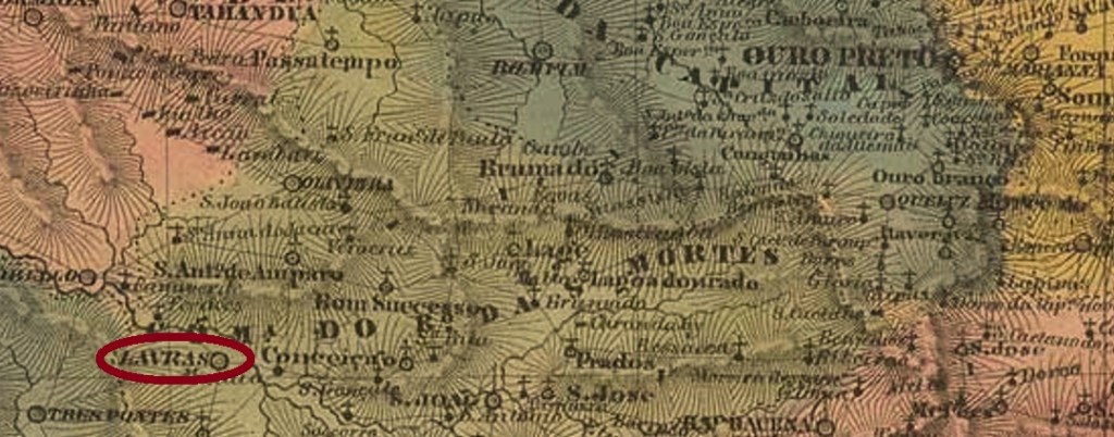
Santo Antonio de Lavras was from November 1847 a district in the Município de Caçapava, more than 300 kilometres southwest of the provincial capital Porto Alegre. In May 1882, it was elevated to the status of a villa. It has been called Lavras do Sul since December 1944.
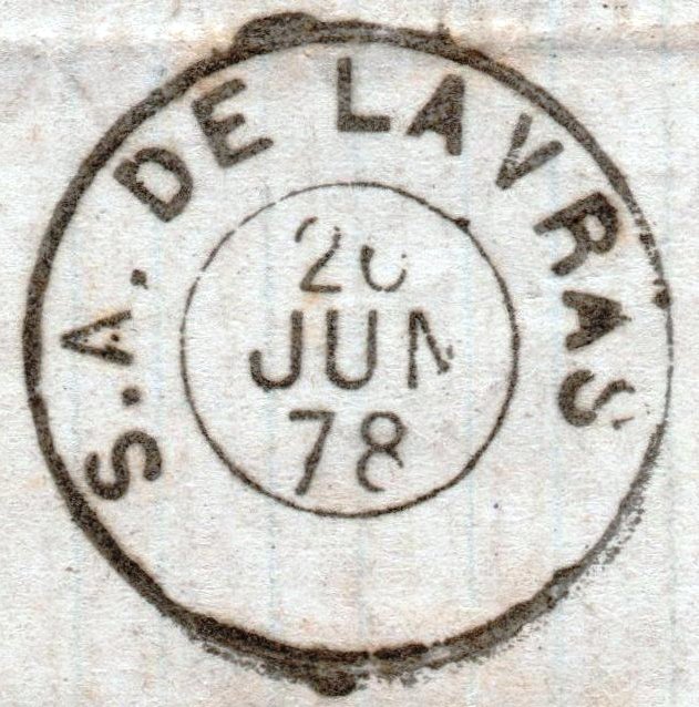
It has not yet been possible to determine the year in which the post office there was established. The oldest postmark to date, SRS-0545a (José A. Junges collection), is dated 1877:
SRS-0545a (JJ) 1877-1878
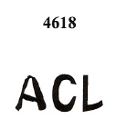
However, there is a presumably earlier letter to Cruz Alta, franked with a D. Pedro stamp of 1866, with a postmark with the initials ACL. This is also recorded in the Catálogo de Carimbos Brasil-Império (S. Paulo, 1937, 1942) by P. Ayres with the no. 1117. Here is LRS-0210a, with an example by Denis Forte:
LRS-0210a (P.A. 1117 / BPA 4617 – DFo) 1866ff
ACL is either the abbreviation for a postal agent or for Agencia do Correio of a place beginning with L, which was probably in the province of São Pedro do Rio Grande do Sul, as the province is not mentioned on this cover. In favour of the second alternative is the existence of a second postmark with the same initials, the one in Mute Cancellations of the Brazil Empire / Carimbos Mudos do Brasil Império (Brazil Philatelic Association, Rio de Janeiro, 2000) by James Dingler and Klerman W. Lopes with no. 4618:
BPA 4618
In imperial Rio Grande do Sul there were three post offices beginning with the letter L: Sant’Anna do Livramento (SRS-0530), Lagoa Vermelha (LRS-0205) and Santo Antonio de Lavras. All known Livramento postmarks mention Sant’Anna, and the missing letter V makes Lagoa Vermelha unlikely. Therefore, LRS-0210a is provisionally attributed to Lavras.
There is no definitive confirmation for the two following cancels, but they may also originate from this province. First the double circle LRS-0210b (fig. Koester in Carimbologia XXVI):
LRS-0210b (RK) 1881-1891
Then the cancel with the imperial seal LRS-0210c (fig. Koester, op. cit.):
LRS-0210c (RK)Villiers de l’Ile Adam: Carta (…) da Provincia de São Pedro do Sul, 1847
Anderer Name: Lavras do Sul (1944)
Siehe auch Santo Antonio de Lavras (SRS-0545)
Santo Antonio de Lavras war ab November 1847 ein Distrito im Município de Caçapava, mehr als 300 km südwestlich der Provinzhauptstadt Porto Alegre. Im Mai 1882 wurde es zur Villa erhoben. Seit Dezember 1944 heißt sie Lavras do Sul.
Das Gründungsjahr des dortigen Postamtes konnte bisher nicht ermittelt werden. Der bisher älteste Stempel SRS-0545a (Samml. José A. Junges) ist auf 1877 datiert:
SRS-0545a (JJ) 1877-1878
Es existiert jedoch ein vermutlich früherer Brief nach Cruz Alta, frankiert mit einer D.Pedro-Marke von 1866, dazu ein Poststempel mit den Initialen ACL. Dieser ist auch im Catálogo de Carimbos Brasil-Império (S. Paulo, 1937, 1942) von P. Ayres mit der Nr. 1117 verzeichnet. Hier ist LRS-0210a, mit einem Beispiel von Denis Forte:
LRS-0210a (P.A. 1117 / BPA 4617 – DFo) 1866ff
ACL ist entweder die Abkürzung für einen Postagenten oder für Agencia do Correio eines Ortes, der mit L beginnt und wahrscheinlich in der Provinz São Pedro do Rio Grande do Sul lag, da die Provinz auf diesem Umschlag nicht erwähnt wird. Für die zweite Alternative spricht das Vorhandensein eines zweiten Poststempels mit den gleichen Initialen, der in Mute Cancellations of the Brazil Empire / Carimbos Mudos do Brasil Império (Brazil Philatelic Association, Rio de Janeiro, 2000) von James Dingler und Klerman W. Lopes mit der Nr. 4618:
BPA 4618
Im kaiserlichen Rio Grande do Sul gab es drei Postämter mit dem Anfangsbuchstaben L: Sant’Anna do Livramento (SRS-0530), Lagoa Vermelha (LRS-0205) und Santo Antonio de Lavras. Alle bekannten Poststempel von Livramento erwähnen Sant’Anna, und der fehlende Buchstabe V macht Lagoa Vermelha unwahrscheinlich. Daher wird LRS-0210a vorläufig Lavras zugeschrieben.
Für die beiden folgenden Stempel fehlt die endgültige Bestätigung, aber auch sie können aus dieser Provinz stammen. Zuerst der Doppelkreis LRS-0210b (Abb. Koester in Carimbologia XXVI):
LRS-0210b (RK) 1881-1891
Dann der Stempel mit dem kaiserlichen Siegel LRS-0210c (Abb. Koester, op. cit.):
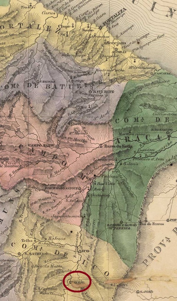
The Freguesia de São Vicente Ferrer das Lavras da Mangabeira on the west bank of the Rio Salgado, 420 kilometres south of the later provincial capital Fortaleza, had existed since August 1813 and belonged to the Vila de Icó. The village became a Vila in June 1816, which became the town of S. Vicente das Lavras in August 1884 and has been called Município de Lavras da Mangabeira since December 1943.
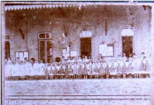
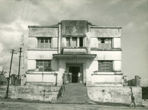
Lavras da Mangabeira post office, ca. 1950 (IBGE)
R. Koester writes in Carimbologia XXVI that there had been a post office there since September 1846. The only postmark in the 19th century to date, LCE-0190b (fig. Koester, op. cit.), shows the imperial seal:
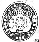
LCE-0190b (RK)Villiers de l’Ile Adam: Carta (…) da Provincia do Ceará, 1849
Andere Namen: Lavras da Mangabeira (1943)
Seit August 1813 bestand die zur Vila de Icó gehörende Freguesia de São Vicente Ferrer das Lavras da Mangabeira am Westufer des Rio Salgado, 420 km südlich der späteren Provinzhauptstadt Fortaleza. Bereits im Juni 1816 wurde der Ort zur Vila, die im August 1884 zur Stadt S. Vicente das Lavras wurde und seit Dezember 1943 Município de Lavras da Mangabeira heißt.
Postamt Lavras da Mangabeira, ca. 1950 (IBGE)
R. Koester schreibt in Carimbologia XXVI, dass es dort seit September 1846 ein Postamt gab. Der bisher einzige Poststempel im 19. Jahrhundert LCE-0190b (Abb. Koester, op. cit.) zeigt den kaiserlichen Siegel:
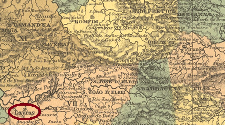
The parish of Sant’Anna de Lavras do Funil was established in July 1813 in the Município of Turvo, close to the south bank of the Rio Grande, about 250 km southwest of the former provincial capital of Ouro Preto. Funil means funnel, and this is still the name of a dam on the Rio Grande about 30 km away. The village rose to the status of Vila in October 1831 and has been a town since July 1868, when it was simply called Lavras.
Three years of origin have been found for the local post office. First in March 1829, as Nova Monteiro writes in Administrações e Agencias Postaes do Brasil Imperio (Brasil Filatelico/RJ, 1934-5; Reprint SPP 1994-1999). Then in October 1833, as can be read in both the Directory of Imperial Post Offices (Tabella das Agencias do Correio do Imperio, Rio de Janeiro, 1885) and the Postal Report (Relatorio Postal) for 1887. And finally in October 1853, as reported by Paula Sobrinho in História Postal de Minas Gerais (Belo Horizonte, 1997). However, this could be a transcription error.
The oldest postmark is LMG-1490a, supposedly used as early as 1835 and presented by the RHM catalogue under P-MG-33:
LMG-1490a (RHM P-MG-33)
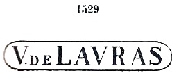
It was followed by VMG-3805a, which was in use between 1839 and at least 1866, also occurs in brown and green and is listed by Paulo Ayres in Catálogo de Carimbos Brasil-Império (S. Paulo, 1937, 1942) under no. 1529:
VMG-3805a (P.A. 1529, RHM P-MG-34)
This was followed by the double circle LMG-3370a (illustration from the Internet):
LMG-3370a (HiltonWA) 1879-1898
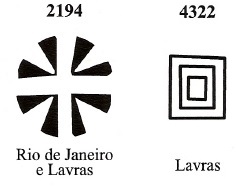
James Dingler and Klerman W. Lopes have listed two mute cancellations from Lavras in Mute Cancellations of the Brazil Empire / Carimbos Mudos do Brasil Império (Brazil Philatelic Association, Rio de Janeiro, 2000):
BPA 2194-4322Villiers de l’Ile Adam: Carta (…) da Provincia de Minas Geraes, 1849
Anderer Name: Lavras do Funil
Siehe auch Villa de Lavras (VMG-3805)
Die Pfarrei von Sant’Anna de Lavras do Funil wurde im Juli 1813 im Município von Turvo errichtet und lag nah am Südufer des Rio Grande, ca. 250 km südwestlich der ehemaligen Provinzhauptstadt Ouro Preto entfernt. Funil bedeutet Trichter, und so heißt bis heute ein ca. 30 km entfernter Staudamm des Rio Grande. Der Ort stieg im Oktober 1831 zur Vila auf und ist seit Juli 1868 eine Stadt, die lediglich Lavras heißt.
Fürs örtliche Postamt wurden drei Entstehungsjahre gefunden. Zunächst im März 1829, wie Nova Monteiro in Administrações e Agencias Postaes do Brasil Imperio, in (Brasil Filatelico/RJ, 1934-5; Reprint SPP 1994-1999) schreibt. Dann im Oktober 1833, wie sowohl im Verzeichnis der kaiserlichen Postämter (Tabella das Agencias do Correio do Imperio, Rio de Janeiro, 1885) als auch im Postbericht (Relatorio Postal) für 1887 zu lesen ist. Und schließlich im Oktober 1853, wie Paula Sobrinho in História Postal de Minas Gerais (Belo Horizonte, 1997) berichtet. Allerdings könnte es sich hier um ein Abschreibfehler handeln.
Der älteste Poststempel ist LMG-1490a, der angeblich bereits 1835 verwendet und durch den RHM-Katalog unter P-MG-33 vorgestellt wurde:
LMG-1490a (RHM P-MG-33)
Ihm folgte VMG-3805a, der zwischen 1839 und zumindest 1866 in Gebrauch war, auch in braun und grün vorkommt und durch Paulo Ayres in Catálogo de Carimbos Brasil-Império (S. Paulo, 1937, 1942) unter Nr. 1529 aufgelistet ist:
VMG-3805a (P.A. 1529, RHM P-MG-34)
Es folgte der Doppelkreis LMG-3370a (Abb. aus dem Internet):
LMG-3370a (HiltonWA) 1879-1898
James Dingler und Klerman W. Lopes haben zwei stumme Abstempelungen aus Lavras in Mute Cancellations of the Brazil Empire / Carimbos Mudos do Brasil Império (Brazil Philatelic Association, Rio de Janeiro, 2000) aufgeführt:
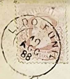
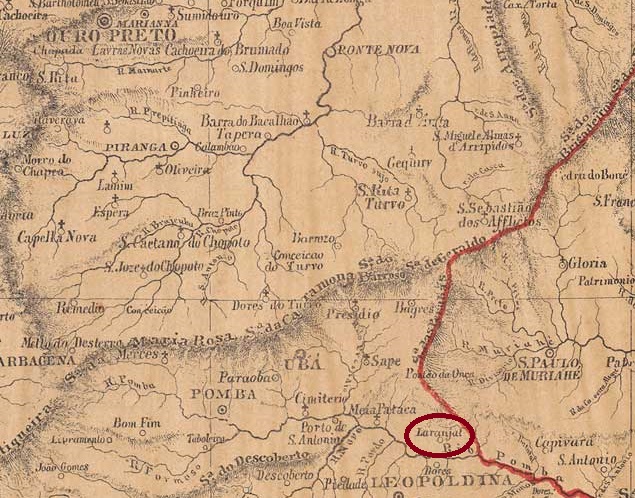
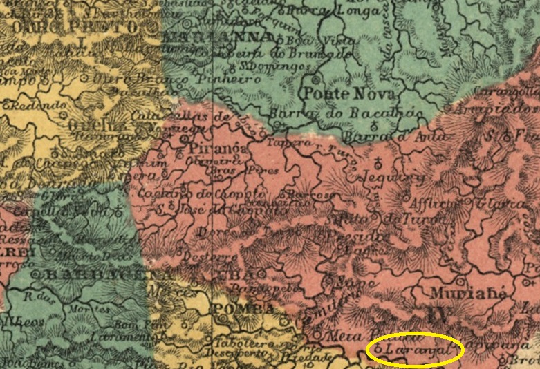
The village had been a distrito of the Vila de Leopoldina since October 1851 and was located on the north bank of the Pomba, 240 kilometres south-east of the provincial capital Ouro Preto. In February 1871 it became the Freguesia de N. Sra. da Conceição do Laranjal, which was subordinated to the Vila de Cataguazes in November 1875. Laranjal has been an independent município since December 1938.
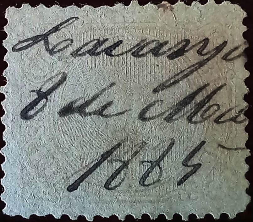
R. Koester (Carimbologia XXVI) and Paula Sobrinho (História Postal de Minas Gerais, Belo Horizonte, 1997) agree that there had been a post office there since November 1880. At first the stamps were cancelled by hand, as the illustration shows (collect. Fuad Ferreira Fo.):
1885 (FF)
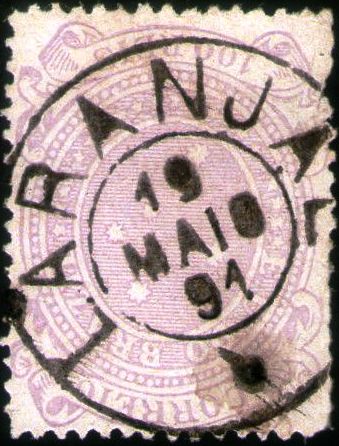
The imperial postmark here is LMG-1485a (collect. Karlheinz Wittig), which also occurs in blue:
LMG-1485a (KW) 1885-1898Atlas do Imperio do Brasil, 1868
Der Ort war seit Oktober 1851 ein Distrito der Vila de Leopoldina und lag am Nordufer des Pomba, 240 km südöstlich der Provinzhauptstadt Ouro Preto. Im Februar 1871 wurde es zur Freguesia de N. Sra. da Conceição do Laranjal, die im November 1875 der Vila de Cataguazes unterstellt wurde. Seit Dezember 1938 ist Laranjal ein unabhängiges Município.
R. Koester (Carimbologia XXVI) und Paula Sobrinho (História Postal de Minas Gerais, Belo Horizonte, 1997) sind sich einig, dass es dort seit November 1880 ein Postamt gab. Zunächst wurden die Briefmarken noch von Hand entwertet, wie die Abbildung zeigt (Samml. Fuad Ferreira Fo.):
1885 (FF)
Der kaiserliche Poststempel ist hier LMG-1485a (Samml. Karlheinz Wittig), der auch in Blau vorkommt:
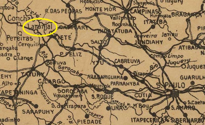
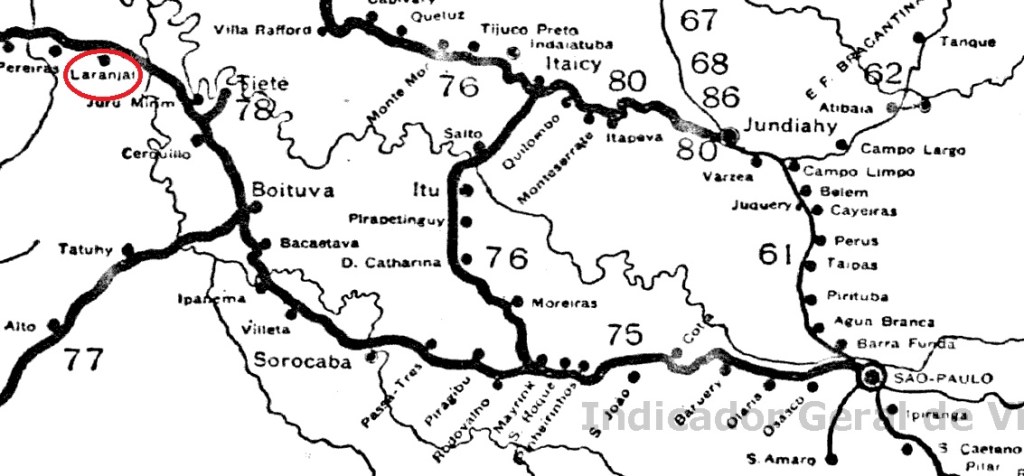
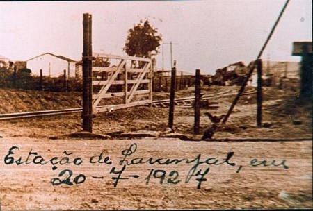
The place was originally a resting place (pouso) for cattle herders on the Ribeirão do Laranjal, Município de Tieté, 160 km north-west of the provincial capital of São Paulo. A railway station of the E.F. Sorocabana railway company (main line) was opened there in June 1886. The line went to the Cia. União Sorocabana e Ytuana in 1892, to the Sorocabana Railway in 1907, to the E.F. Sorocabana in 1919 and belonged to the FEPASA consortium from 1971 until it was closed in 1998 (estacoesferroviarias.com.br). The tracks are still there today, but the station building has been demolished.
In 1927 (Photo: laranjalpaulista.sp.gov.br, on estacoesferroviarias.com.br)
The area around the railway station became a district in the Município de Tietê in November 1896. In October 1917, Laranjal became an independent Município de Laranjal, which has been called Laranjal Paulista since November 1944.
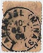
As R. Koester writes in Carimbologia XXVI, there had been a post office at the railway station since May 1886. The imperial postmark is LSP-0745a (illus. Claudio Coelho):
LSP-0745a (CC) 1889-1897Cia. Sorocabana e Ytuana, 1898 (IBGE)
Andere Namen: Laranjal Paulista (1944)
Der Ort war ursprünglich ein Rastplatz (Pouso) für Viehhirten am Ribeirão do Laranjal, Município de Tieté, 160 km nordwestlich der Provinzhauptstadt São Paulo. Dort wurde im Juni 1886 ein Bahnhof der Eisenbahngesellschaft E.F. Sorocabana (Hauptstrecke) eröffnet. Die Strecke ging 1892 an die Cia. União Sorocabana e Ytuana, 1907 an die Sorocabana Railway, 1919 an die E.F. Sorocabana und gehörte von 1971 bis zur Stilllegung 1998 dem Konsortium FEPASA (estacoesferroviarias.com.br). Heute sind die Gleise noch vorhanden, das Bahnhofsgebäude wurde abgerissen.
1927 (Foto: laranjalpaulista.sp.gov.br, auf estacoesferroviarias.com.br)
Das Gebiet um den Bahnhof wurde im November 1896 ein Distrito im Município de Tietê. Im Oktober 1917 wurde Laranjal ein unabhängiger Município de Laranjal, der seit November 1944 Laranjal Paulista heißt.
Wie R. Koester in Carimbologia XXVI schreibt, gab es am Bahnhof seit Mai 1886 ein Postamt. Der kaiserliche Poststempel ist LSP-0745a (Abb. Claudio Coelho):