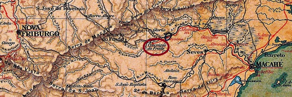
Other names: Conceição do Frade, Frades, Glicério, Crubixais
The settlement of N. Sra. da Conceição do Arraial dos Frades was founded around 1850, belonged to the Freguesia de N. Sra. das Neves in the Município de Macaé and was located on the south bank of the Macabu, 170 kilometres north-east of the capital Rio de Janeiro. In October 1862, it became the Distrito de Arraial de Frades, which has since changed its name four times: in November 1910 to Glicério, in December 1943 to Crubixais, in October 1951 again to Glicério and finally in December 2004 to Frade.
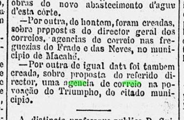
According to the regional press, there had been a post office in the town since August 1881:
Gazeta de Noticias, 13/08/1881
According to P. Novaes (agenciaspostais.com.br), the post office was closed ‘around 1914’. No imperial postmark has been seen here either.
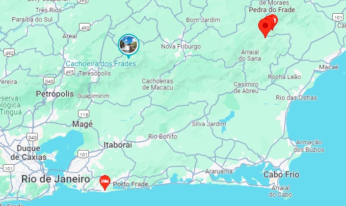
Google Maps
Andere Namen: Conceição do Frade, Frades, Glicério, Crubixais
Die Siedlung N. Sra. da Conceição do Arraial dos Frades entstand um 1850, gehörte zur Freguesia de N. Sra. das Neves im Município de Macaé und lag am Südufer des Macabu, 170 km nordöstlich der Hauptstadt Rio de Janeiro. Im Oktober 1862 wurde es zum Distrito de Arraial de Frades, der seitdem viermal seinen Namen geändert hat: im November 1910 in Glicério, im Dezember 1943 in Crubixais, im Oktober 1951 wieder in Glicério und schließlich im Dezember 2004 in Frade.
Wie die regionale Presse berichtete, gab es seit August 1881 ein Postamt am Ort:
Gazeta de Noticias, 13.08.1881
Laut P. Novaes (agenciaspostais.com.br) wurde das Postamt “um 1914” geschlossen. Auch hier wurde bisher kein kaiserlicher Poststempel gesehen.
Carta da Republica dos Estados Unidos do Brazil, 1892
From July 1858, Forte (fortress) was a district of the Vila de Flores, located 500 kilometres northwest of the provincial capital Goyaz (today Goiás Velho), and became the capital of this Vila in December 1862. In August 1869, the town was elevated to Vila de S. Sebastião do Forte. The 20th century brought economic decline: in March 1931, Forte was downgraded to a district of the Município de S. João d’Aliança, and belonged to the Município de Formosa from October 1938 to October 1953, before returning to S. João d’Aliança.
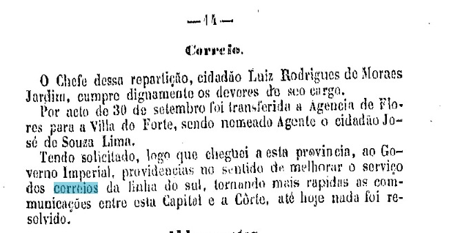
Two periods of operation were found for the local post office. According to the Directory of Imperial Post Offices (Tabella das Agencias do Correio do Imperio, Rio de Janeiro, 1885), the first period began in 1832 and ended before 1854, as the post office is not mentioned in the Postal Guide (Guia do Correio do Brasil, Rio de Janeiro, 1856). The second period began in September 1878, as can be seen from the provincial president’s report of January of the following year:
Relatorio do Presidente da Provincia, January 1879.
No imperial postmark from Forte has yet been seen.
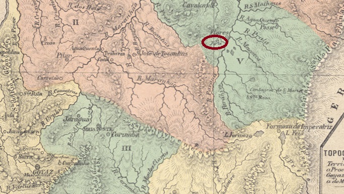
Atlas do Imperio do Brasil, 1868
Seit Juli 1858 war Forte (Festung) ein Distrikt der Vila de Flores, 500 km nordwestlich der Provinzhauptstadt Goyaz (heute Goiás Velho) gelegen, und wurde im Dezember 1862 Hauptort dieser Vila. Im August 1869 wurde der Ort zur Vila de S. Sebastião do Forte erhoben. Im 20. Jahrhundert kam der wirtschaftliche Niedergang: Im März 1931 wurde Forte zu einem Distrikt des Município de S. João d’Aliança herabgestuft, der von Oktober 1938 bis Oktober 1953 zum Município de Formosa gehörte, bevor er wieder zu S. João d’Aliança zurückkehrte.
Für das örtliche Postamt wurden zwei Betriebszeiten gefunden. Nach dem Verzeichnis der kaiserlichen Postämter (Tabella das Agencias do Correio do Imperio, Rio de Janeiro, 1885) begann die erste Periode 1832 und endete vor 1854, da das Postamt im Postführer (Guia do Correio do Brasil, Rio de Janeiro, 1856) nicht erwähnt wird. Die zweite Periode begann im September 1878, wie aus dem Bericht des Provinzpräsidenten vom Januar des folgenden Jahres hervorgeht:
Relatorio do Presidente da Provincia, Januar 1879
Bisher wurde kein kaiserlicher Poststempel aus Forte gesehen.
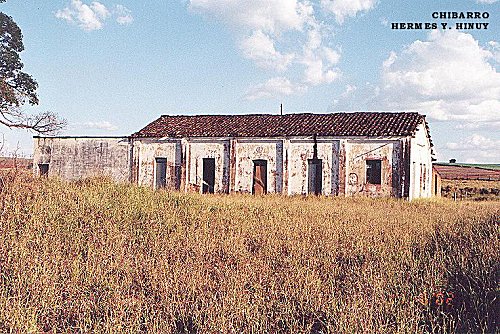
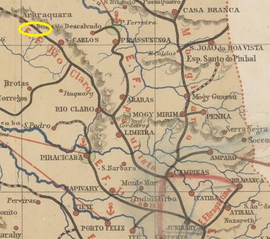
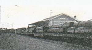
Fortaleza station was opened in December 1884 by the railway company E.F. do Rio Claro (Main Line) and is located between the river Chibarro and the Fazenda Fortaleza in the Município Araraquara, 270 km north-west of the provincial capital São Paulo. The line was taken over by the Rio Claro Railway in 1888 and belonged to the Cia. Paulista de Estradas de Ferro from 1892 until it was closed in 1922. The station was replaced by Chibarro station, 400 metres away. The tracks no longer exist today and the old station building is an abandoned ruin (estacoesferroviarias.com.br).
In 1918 (Photo: Filemon Peres, on estacoesferroviarias.com.br)In June 2002 (Photo: Hermes Hinuy, on estacoesferroviarias.com.br)
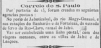
Two dates of origin were found for the railway station post office. R. Koester (Carimbologia XIX) gives February 1887, but the regional press reports a date in the following month:
Correio Paulistano, 18/03/1887
According to the philatelist Mario Celso Orsi Jr. the post office was closed in January 1899. No imperial postmark from Fortaleza station has yet been seen.
Provincia de São Paulo, 1886
Der Bahnhof Fortaleza wurde im Dezember 1884 von der Eisenbahngesellschaft E.F. do Rio Claro (Hauptstrecke) eröffnet und liegt zwischen dem Fluss Chibarro und der Fazenda Fortaleza im Município Araraquara, 270 km nordwestlich der Provinzhauptstadt São Paulo. Die Strecke wurde 1888 von der Rio Claro Railway übernommen und gehörte von 1892 bis zu ihrer Stilllegung 1922 der Cia. Paulista de Estradas de Ferro. Der Bahnhof wurde durch den 400 m entfernten Bahnhof Chibarro ersetzt. Die Gleise existieren heute nicht mehr, das alte Bahnhofsgebäude ist eine verlassene Ruine (estacoesferroviarias.com.br).
1918 (Foto: Filemon Peres, auf estacoesferroviarias.com.br)Juni 2002 (Foto: Hermes Hinuy, auf estacoesferroviarias.com.br)
Für das Bahnhofspostamt wurden zwei Entstehungsdaten gefunden. R. Koester (Carimbologia XIX) gibt Februar 1887 an, aber die regionale Presse berichtet von einem Datum im Folgemonat:
Correio Paulistano, 18.03.1887
Nach Angaben des Philatelisten Mario Celso Orsi Jr. wurde das Postamt im Januar 1899 geschlossen. Bisher wurde noch kein kaiserlicher Poststempel vom Bahnhof Fortaleza gesehen.
Other names: Fortaleza do Rio Novo, Assentamento Denis Gonçalves (2013)
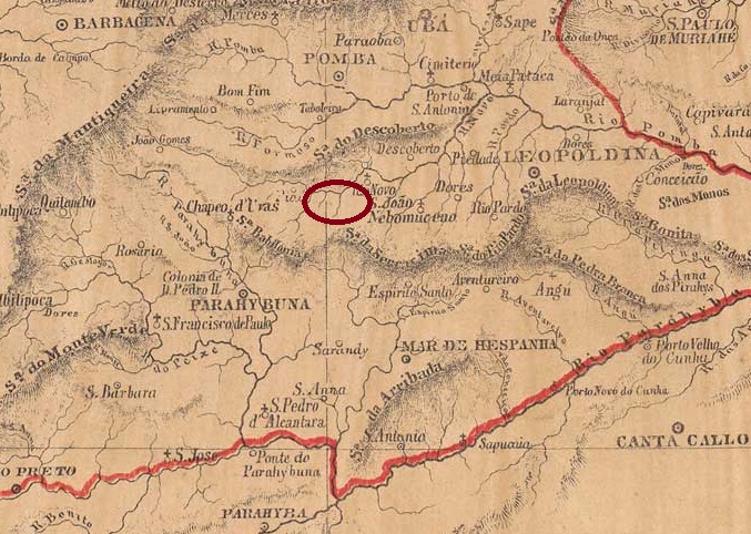
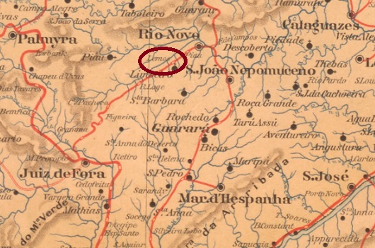
Around 1811, the Fazenda da Fortaleza do Rio Novo was founded 230 kilometres south of the later provincial capital Ouro Preto. Shortly afterwards, it belonged to Lieutenant José Joaquim de Santana, a large landowner of the so-called Zona da Mata region, whose land holdings were estimated at up to 46 km2. After his death in April 1845, the estate – then known as Fortaleza de Sant’anna – passed to his widowed daughter Maria José, who later became Baroness de Santana.
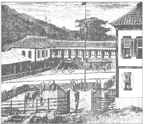
The fazenda in the 19th century (Faculdade de Comunicação – UFJF)
Maria José’s first-born son, Mariano Procópio Ferreira Lage (1821-1872), an aspiring politician, industrialist and entrepreneur, took over the fazenda and immediately integrated it into his main endeavour: the construction of a road from Rio de Janeiro to Minas Gerais through his own company, Cia. União e Industria.
Mariano Procópio Ferreira Lage
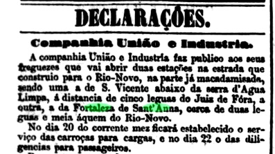
In October 1870, Cia. União e Industria announced the construction of an estação (carriage stop) on its road in Fortaleza de Sant’Anna (Juiz de Fora – Rio Novo Route):
Jornal do Commercio, 14/10/1870
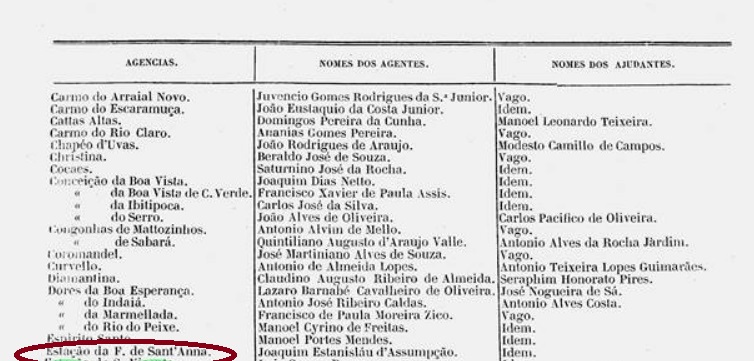
However, the early death of Ferreira Lage in 1872 signalled the decline of the fazenda and the road project. Nevertheless, shortly afterwards a still undiscovered post office was set up in Fortaleza de Sant’Anna on the important postal route from Ouro Preto to Rio de Janeiro. The regional press introduced the postal agent at the end of 1873:
Almanak Laemmert/MG, 1874
The postal agency was not in operation for long, as it is not mentioned in the imperial postal guide (Guia Postal do Imperio, Rio de Janeiro, 1880). No postmark of the Fortaleza de Sant’Anna has yet been seen; it must be very rare, if it exists at all.
The proud road construction project of the Cia. União e Industria has been forgotten since the appearance of the E.F. de Juiz de Fora e Piau railway line. Two railway stations on this line remember the ruling family from the fazenda: Sant’Anna (later Faria Lemos, latterly Ferreira Lage, see FMG-0970) and Campello (formerly Capim, later Goianá, see CMG-0500).
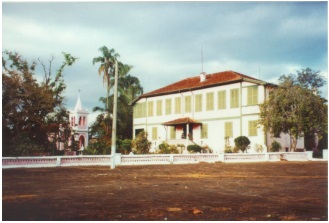
The Fazenda da Fortaleza de Sant’Anna also experienced a long decline due to the end of the coffee industry in the region, debts and decades of inheritance disputes. The main building was still good-looking in 2000:
L. and E. Agassiz: Viagem ao Brasil 1865-1866, Brasilia 2000
The following year, a fire destroyed the main building in the Município Goianá. From 2010, the former fazenda, which is now spread over 4 municípios, was occupied by landless farmers from the Movimento dos Sem-Terras (MST). Today, around 300 families live on the formerly fallow farmland. The settlement is now called Assentamento Denis Gonçalves, in memory of a young MST farmer who died in an accident.
Estado de Minas Geraes, 1910
Andere Namen: Fortaleza do Rio Novo, Assentamento Denis Gonçalves (2013)
Um 1811 wurde 230 km südlich der späteren Provinzhauptstadt Ouro Preto die Fazenda da Fortaleza do Rio Novo gegründet. Sie gehörte kurz darauf dem Leutnant José Joaquim de Santana, einem Großgrundbesitzer der sogenannten Zona da Mata, dessen Landbesitz auf bis zu 46 km2 geschätzt wurde. Nach seinem Tod im April 1845 ging das Gut – nun unter dem Namen Fortaleza de Sant’anna – an seine bereits verwitwete Tochter Maria José, die spätere Baronin von Santana, über.
Die Fazenda im 19. Jahrhundert (Faculdade de Comunicação – UFJF)
Maria Josés erstgeborener Sohn, Mariano Procópio Ferreira Lage (1821-1872), ein aufstrebender Politiker, Industrieller und Unternehmer, übernahm die Fazenda und integrierte sie sofort in sein Hauptanliegen: den Bau einer Fernstraße von Rio de Janeiro nach Minas Gerais durch seine eigene Firma Cia. União e Industria.
Mariano Procópio Ferreira Lage
Im Oktober 1870 kündigte die Cia. União e Industria die Einrichtung einer Haltestelle an ihrer Fernstraße in Fortaleza de Sant’Anna (Strecke Juiz de Fora – Rio Novo) an:
Jornal do Commercio, 14.10.1870
Der frühe Tod von Ferreira Lage im Jahre 1872 leitete jedoch den Niedergang der Fazenda und des Straßenprojekts ein. Immerhin wurde kurz darauf in Fortaleza de Sant‘Anna an der wichtigen Postroute von Ouro Preto nach Rio de Janeiro ein Postamt eingerichtet, von dem bisher nirgendwo zu lesen war. Die regionale Presse stellte den Postagenten Ende 1873 vor:
Almanak Laemmert/MG, 1874
Die Postagentur war nicht lange in Betrieb, da sie im kaiserlichen Postführer (Guia Postal do Imperio, Rio de Janeiro, 1880) nicht erwähnt wird. Bisher wurde noch kein Poststempel der Fortaleza de Sant’Anna gesehen, er muss sehr selten sein, wenn er überhaupt existiert.
Das stolze Straßenbauprojekt der Cia. União e Industria ist seit der Inbetriebnahme der Eisenbahnlinie E.F. de Juiz de Fora e Piau in Vergessenheit geraten. Zwei Bahnhöfe an dieser Strecke erinnern an die Herrscherfamilie der Fazenda: Sant’Anna (später Faria Lemos, zuletzt Ferreira Lage, siehe FMG-0970) und Campello (früher Capim, später Goianá, siehe CMG-0500).
Auch die Fazenda da Fortaleza de Sant’Anna erlebte einen langen Niedergang, bedingt durch das Ende der Kaffeewirtschaft in der Region, Schulden und jahrzehntelange Erbstreitigkeiten. Das Hauptgebäude war im Jahr 2000 noch ansehnlich:
Foto von L. und E. Agassiz: Viagem ao Brasil1865-1866, Brasilia 2000
Im folgenden Jahr zerstörte ein Brand das Hauptgebäude im Município Goianá. Ab 2010 wurde die ehemalige Fazenda, deren Areal sich heute auf 4 Municípios verteilt, von landlosen Bauern des Movimento dos Sem-Terras (MST) besetzt. Heute leben ca. 300 Familien auf dem ehemals brachliegenden Hofgelände. Die Siedlung heißt nun Assentamento Denis Gonçalves, in Erinnerung an einen verunglückten Bauernjungen des MST.
Villiers de l’Ile Adam: Carta (…) da Provincia de Minas Geraes, 1849
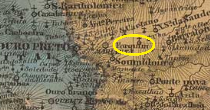
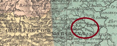
Other names: Furquim, Monte Forquim
From February 1718, Forquim (also spelt Furquim) was a district of the Vila de Ribeirão do Carmo on the north bank of the Carmo, 40 kilometres east of the later provincial capital of Ouro Preto. This has remained the case to this day, except that Ribeirão do Carmo became the Vila de Mariana in April 1745 and Forquim became the Freguesia de Senhor Bom Jesus do Forquim in February 1871. The name is a reminder of an early landowner.
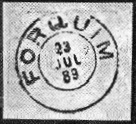
Paula Sobrinho (História Postal de Minas Gerais, Belo Horizonte, 1997), R. Koester (Carimbologia XIX) and the postal report (Relatorio Postal) of 1886 all agree that there was a post office there from December 1880, although the former mentions Forquim as the railway station. The imperial postmark is FMG-1195a (fig. R. Koester, op. cit.):
FMG-1195a (RK) 1889Atlas do Imperio do Brasil, 1868
Andere Namen: Furquim, Monte Forquim
Seit Februar 1718 war Forquim (auch Furquim geschrieben) ein Distrito der Vila de Ribeirão do Carmo am Nordufer des Carmo, 40 km östlich der späteren Provinzhauptstadt Ouro Preto. Dies ist bis heute so geblieben, nur wurde Ribeirão do Carmo im April 1745 zur Vila de Mariana und Forquim im Februar 1871 zur Freguesia de Senhor Bom Jesus do Forquim. Der Name soll an einen frühen Grundbesitzer der Region erinnern.
Paula Sobrinho (História Postal de Minas Gerais, Belo Horizonte, 1997), R. Koester (Carimbologia XIX) und der Postbericht (Relatorio Postal) von 1886 berichten übereinstimmend, dass es dort ab Dezember 1880 ein Postamt gab, obwohl erstere Forquim als Bahnhof angibt. Der kaiserliche Poststempel ist FMG-1195a (Abb. R. Koester, op. cit.):
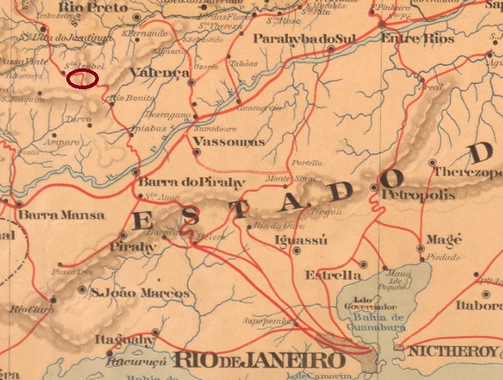
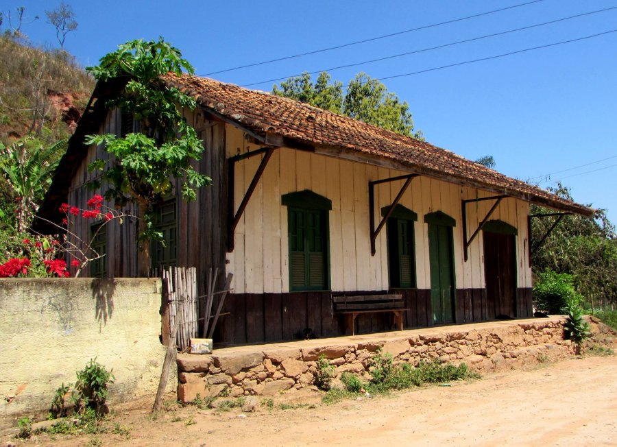
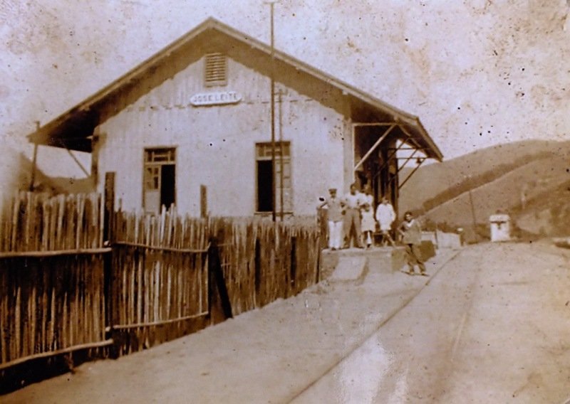
Forquilha (Fork) station was opened in January 1886 by the railway company E.F. Sta. Izabel do Rio Preto (Barra Line) in the Município Valença, 180 km north-west of Rio de Janeiro. The station then changed its name twice: in 1889 to José Leite and in 1936 to Leite de Souza. In 1893 the line became the property of V.F. Sapucaí, in 1910 of Rede Sul-Mineira and from 1931 until its closure in 1961 of Rede Mineira de Viação. Today, the tracks have disappeared and the station building serves as a residential building.
Around 1930 (Photo: NN, on estacoesferroviarias.com.br)In 2016 (Photo: Alexandre Ferreira, on estacoesferroviarias.com.br)
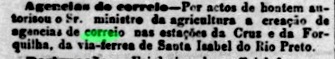
According to the Rio press, there was a post office at the railway station from January 1887:
Jornal do Commercio, 27/01/1887
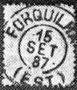
Paulo Novaes writes on agenciaspostais.com.br that the post office was also renamed around 1888. Seen in this light, the first postmark FRJ-0555a (fig. R. Koester, on Carimbologia XIX) would be quite rare:
FRJ-0555a (RK) 1887Almanak Laemmert, 1892
Andere Namen: José Leite, Leite de Souza (1936)
Der Bahnhof Forquilha (Gabelung) wurde im Januar 1886 von der Eisenbahngesellschaft E.F. Sta. Izabel do Rio Preto (Linie Barra) eröffnet und lag im Município Valença, 180 km nordwestlich von Rio de Janeiro. Danach änderte der Bahnhof zweimal seinen Namen: 1889 in José Leite und 1936 in Leite de Souza. 1893 ging die Strecke in den Besitz der V.F. Sapucaí über, 1910 in den der Rede Sul-Mineira und von 1931 bis zu ihrer Stilllegung 1961 in den der Rede Mineira de Viação. Heute sind die Gleise verschwunden, das Bahnhofsgebäude dient als Wohnhaus.
Um 1930 (Foto: NN, auf estacoesferroviarias.com.br)2016 (Foto: Alexandre Ferreira, auf estacoesferroviarias.com.br)
Wie aus der Presse in Rio hervorgeht, gab es ab Januar 1887 ein Postamt am Bahnhof:
Jornal do Commercio, 27.01.1887
Paulo Novaes schreibt auf agenciaspostais.com.br, dass bereits um 1888 auch das Postamt umbenannt wurde. So gesehen wird der erste Poststempel FRJ-0555a (Abb. R. Koester, auf Carimbologia XIX) ziemlich selten sein:
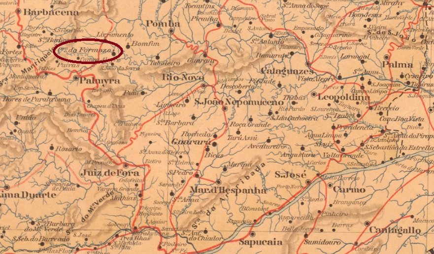
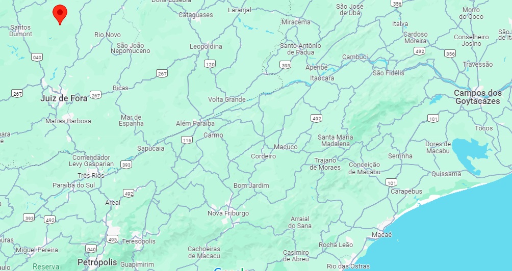
In September 1887, the Freguesia N. Sra. da Conceição do Formoso was founded, which belonged to the Vila de Barbacena and was located on the east bank of the Formoso, 200 km south of the capital Ouro Preto. In July 1889, the freguesia was transferred to the Vila de Palmira and has been a district of the Município de Santos Dumont since July 1932.
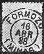
As Paula Sobrinho (História Postal de Minas Gerais, Belo Horizonte, 1997) and R. Koester (Carimbologia XIX) agree, there had been a post office there since January 1888. The imperial postmark is FMG-1190a (RK):
FMG-1190a (RK) 1888Google Maps
Andere Namen: Conceição do Formoso
Im September 1887 wurde die Freguesia N. Sra. da Conceição do Formoso gegründet, die zur Vila de Barbacena gehörte und am Ostufer des Formoso lag, 200 km südlich der Hauptstadt Ouro Preto. Im Juli 1889 wechselte die Freguesia zur Vila de Palmira und ist seit Juli 1932 ein Distrikt des Município de Santos Dumont.
Wie Paula Sobrinho (História Postal de Minas Gerais, Belo Horizonte, 1997) und R. Koester (Carimbologia XIX) übereinstimmend schreiben, gab es dort seit Januar 1888 ein Postamt. Der kaiserliche Poststempel ist FMG-1190a (RK):
Estações (…) do Rio de Janeiro, São Paulo e Minas Geraes, 1880
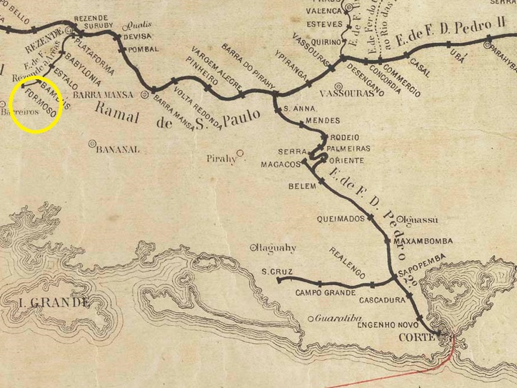
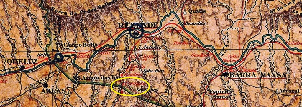
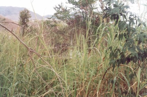
Formoso station (also spelt Formozo) was opened in January 1878 by the railway company E.F. de Resende a Areias (Main Line) and was located on the east bank of the Formoso in the Município de S. José do Barreiro, 290 km east of the provincial capital of São Paulo. The line was in operation until 1928. Today, there are no longer any tracks or station buildings, only ruins can still be recognised.
In 2001 (Photo: Marco Giffoni on estacoesferroviarias.com.br)
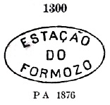
As the station was located just outside the provincial border, its post office was operated by the Rio postal administration until 1900. Two founding dates have been found for the station post office. Paulo Novaes (agenciaspostais.com.br) mentions July 1878, while R. Koester (Carimbologia XIX) gives the same date exactly four years later. The oldest postmark is FSP-0540a, which was given the no. 1300 by P. Ayres (Catálogo de Carimbos Brasil-Império, S. Paulo, 1937, 1942):
FSP-0540a (P.A. 1300) 1878ff
This was followed by the double circle FSP-0540b (fig. R. Koester, op. cit.):
FSP-0540b (RK) 1881
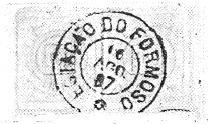
FSP-0540c (fig. R. Koester) also appeared afterwards:
FSP-0540c (RK) 1885-1888Almanak Laemmert, 1892
Der Bahnhof Formoso (auch Formozo geschrieben) wurde im Januar 1878 von der Eisenbahngesellschaft E.F. de Resende a Areias (Hauptlinie) eröffnet und lag am Ostufer des Formoso im Município de S. José do Barreiro, 290 km östlich der Provinzhauptstadt São Paulo. Die Strecke war bis 1928 in Betrieb. Heute sind weder Gleise noch Bahnhofsgebäude mehr vorhanden, nur Ruinenreste sind noch zu erkennen.
2001 (Foto: Marco Giffoni auf estacoesferroviarias.com.br)
Da der Bahnhof unmittelbar vor der Provinzgrenze lag, wurde sein Postamt bis 1900 von der Postverwaltung Rio betrieben. Für das Bahnhofspostamt wurden zwei Gründungsdaten gefunden. Paulo Novaes (agenciaspostais.com.br) nennt den Juli 1878, während R. Koester (Carimbologia XIX) das gleiche Datum erst vier Jahre später angibt. Der älteste Poststempel ist FSP-0540a der von P. Ayres (Catálogo de Carimbos Brasil-Império, S. Paulo, 1937, 1942) die Nr. 1300 erhielt:
FSP-0540a (P.A. 1300) 1878ff
Es folgte der Doppelkreis FSP-0540b (Abb. R. Koester, op. cit.):
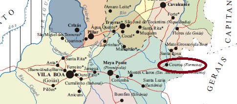
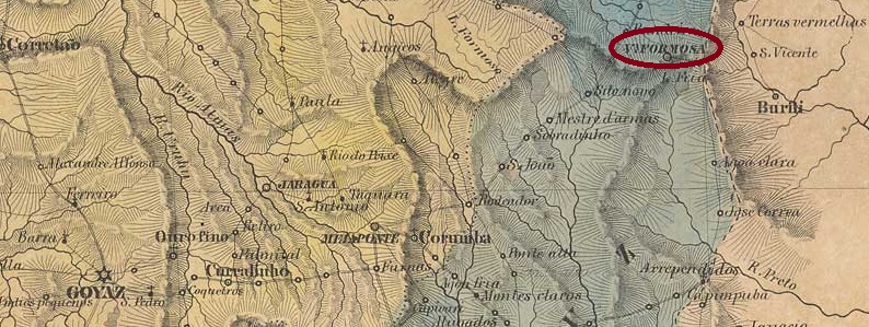
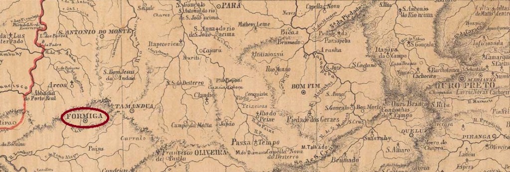
Couros (pieces of leather) was from around 1750 an arraial of the Freguesia de Sta. Luzia on the west bank of the Rio Preto, 390 km east of the later provincial capital Goyaz (today: Goiás Velho). The village was elevated to a freguesia in August 1838 and five years later to Villa Formosa da Imperatriz. It has been the town of Formosa since July 1877.
As Nova Monteiro writes in Administrações e Agencias Postaes do Brasil Imperio (Brasil Filatelico/RJ, 1934-5; Reprint SPP 1994-1999), there had been a post office there since March 1829. A second post office is said to have been opened in February 1835, as R. Koester writes in Carimbologia XIX. This post office was still in operation in 1839, as can be seen from a report by the imperial ministry:
Relatorio do Ministerio do Imperio, 1839
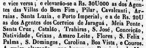
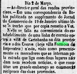
It is not known when the Couros postal agency was closed. However, since the name change to Formosa took place in August 1843, postmarks from Couros from this date onwards are rather unlikely. R. Koester mentions two post office openings for Villa Formosa in Carimbologia XIX, in 1863 and 1869. In between, in March 1866, a postal line was applied for between Formosa and Carinhanha (Bahia province), which would indicate the existence of postal activities in both places:
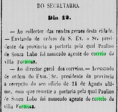
Correio Official de Goyaz, 14/03/1866
The opening of the post office in 1869 is confirmed by the regional press:
Correio Official de Goyaz, 23/10/1869
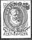
Koester (op. cit.) mentions the postmark FGO-0075b (without illustration) in blue in 1884.
Villiers de l’Ile Adam: Carta (…) da Provincia de Goyaz, 1849
Andere Namen: Couros, Villa Formosa da Imperatriz
Siehe auch Couros (CGO-0052)
Couros (Lederstücke) war ab ca. 1750 ein Arraial der Freguesia de Sta. Luzia am Westufer des Rio Preto, 390 km östlich der späteren Provinzhauptstadt Goyaz (heute: Goiás Velho). Der Ort wurde im August 1838 zur Freguesia und fünf Jahre später zur Villa Formosa da Imperatriz erhoben. Seit Juli 1877 ist es die Stadt Formosa.
Wie Nova Monteiro in Administrações e Agencias Postaes do Brasil Imperio (Brasil Filatelico/RJ, 1934-5; Reprint SPP 1994-1999) schreibt, gab es dort seit März 1829 ein Postamt. Eine zweite Postamteröffnung soll im Februar 1835 stattgefunden haben, wie R. Koester in Carimbologia XIX schreibt. 1839 war dieses Postamt noch in Betrieb, wie aus einem Bericht des kaiserlichen Ministeriums hervorgeht:
Relatorio do Ministerio do Imperio, 1839
Es ist nicht bekannt, wann die Postagentur von Couros geschlossen wurde. Da aber die Namensänderung in Formosa im August 1843 erfolgte, sind Poststempel von Couros ab diesem Datum eher unwahrscheinlich. R. Koester erwähnt zwei Postamteröffnungen für die Villa Formosa in Carimbologia XIX, in den Jahren 1863 und 1869. Dazwischen, im März 1866, wurde eine Postlinie zwischen Formosa und Carinhanha (Provinz Bahia) beantragt, was auf die Existenz eines aktiven Postamtes in beiden Orten hindeuten würde:
Correio Official de Goyaz, 14.03.1866
Die Eröffnung des Postamts 1869 wird durch die regionale Presse bestätigt:
Correio Official de Goyaz, 23.10.1869
Koester (op. cit.) erwähnt den Kreisstempel FGO-0075b (ohne Abbildung) mit der Jahreszahl 1884 in blau.
The parish of S. Vicente Ferrer da Formiga was established in July 1832 in the município of Tamanduá, 290 km west of the provincial capital Ouro Preto. There was no danger to the ant (Formiga) from the anteater (Tamanduá) because the Serra Geral lies between both. In March 1839, the village rose to become Villa Nova da Formiga, and has been a town since June 1858.
Both Paula Sobrinho (História Postal de Minas Gerais, Belo Horizonte, 1997) and Reinhold Koester (Carimbologia XIX) agree that the local post office was created in March 1840. Two early postmarks have already been recorded. VMG-3644a also exists in sepia, was used from 1840 to at least 1843 and is known through the RHM catalogue:
VMG-3644a (RHM P-MG-28) 1840-1843ff
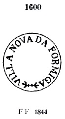
Its successor VMG-3645a was in use from about 1843 and was already known by Paulo Ayres (Catálogo de Carimbos Brasil-Império, S. Paulo, 1937, 1942) with no. 1600:
VMG-3645a (P.A.1600) 1843ff-1846
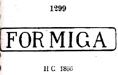
Later postmarks bear only the place name FORMIGA. The first was FMG-1180a, which was already presented by P. Ayres (Catálogo de Carimbos Brasil-Império, S. Paulo, 1937, 1942) under no. 1299:
FMG-1180a (P.A. 1299) 1850ff-1866ff
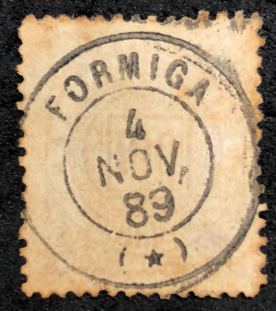
This was followed by the French type FMG-1180b (ill. Roberto Assef Jr.), which was used for quite a long time:
FMG-1180b (RA) 1877-1913
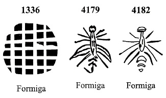
Three other mute cancels from Formiga were shown by James Dingler and Klerman W. Lopes in Mute Cancellations of the Brazil Empire/ Carimbos Mudos do Brasil Império (Brazil Philatelic Association, Rio de Janeiro, 2000) under the numbers 1336, 4179 and 4182:
BPA 1336 (P.A. 271, 1882-1883) – 4179 (1877) – 4182Atlas do Imperio do Brasil, 1868
Siehe auch Villa da Formiga (VMG-3644)
Die Pfarrei S. Vicente Ferrer da Formiga wurde im Juli 1832 im Município Tamanduá errichtet, 290 km westlich der Provinzhauptstadt Ouro Preto. Der Ameisenbär (Tamanduá) stellte keine Gefahr für die Ameise (Formiga) dar, da zwischen beiden die Serra Geral liegt. Im März 1839 wurde der Ort Villa Nova da Formiga und im Juni 1858 zur Stadt erhoben.
Paula Sobrinho (História Postal de Minas Gerais, Belo Horizonte, 1997) und Reinhold Koester (Carimbologia XIX) sind sich einig, dass das örtliche Postamt im März 1840 gegründet wurde. Zwei frühe Poststempel sind bereits bekannt. VMG-3644a existiert auch in Sepia, wurde von 1840 bis mindestens 1843 verwendet und ist aus dem RHM-Katalog bekannt:
VMG-3644a (RHM P-MG-28) 1840-1843ff
Der Nachfolger VMG-3645a wurde ab ca. 1843 verwendet und ist durch Paulo Ayres (Catálogo de Carimbos Brasil-Império, S. Paulo, 1937, 1942) mit der Nr. 1600 bekannt:
VMG-3645a (P.A.1600) 1843ff-1846
Spätere Poststempel tragen nur noch die Ortsbezeichnung FORMIGA. Der erste war FMG-1180a, die bereits von P. Ayres (Catálogo de Carimbos Brasil-Império, S. Paulo, 1937, 1942) unter der Nr. 1299 vorgestellt wurde:
FMG-1180a (P.A. 1299) 1850ff-1866ff
Danach erschien der französische Typ FMG-1180b (Abb. Roberto Assef Jr.), der recht lange verwendet wurde:
FMG-1180b (RA) 1877-1913
Drei weitere stumme Stempel aus Formiga wurden von James Dingler und Klerman W. Lopes in Mute Cancellations of the Brazil Empire/ Carimbos Mudos do Brasil Império (Brazil Philatelic Association, Rio de Janeiro, 2000) unter den Nummern 1336, 4179 und 4182 gezeigt: