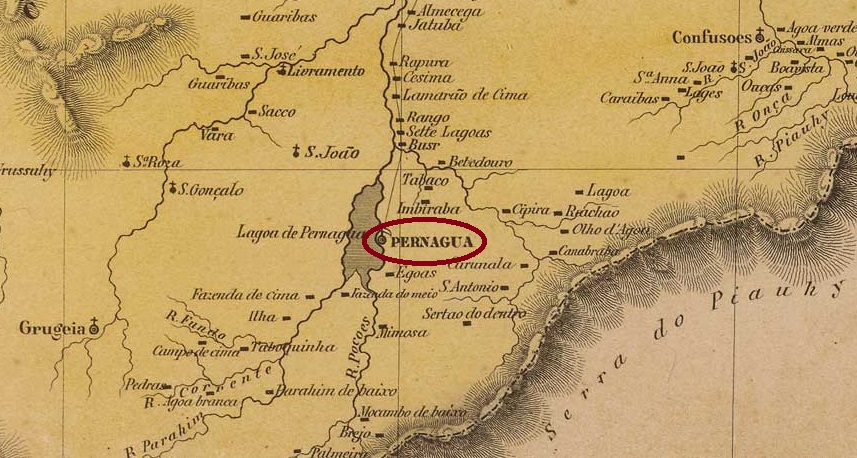
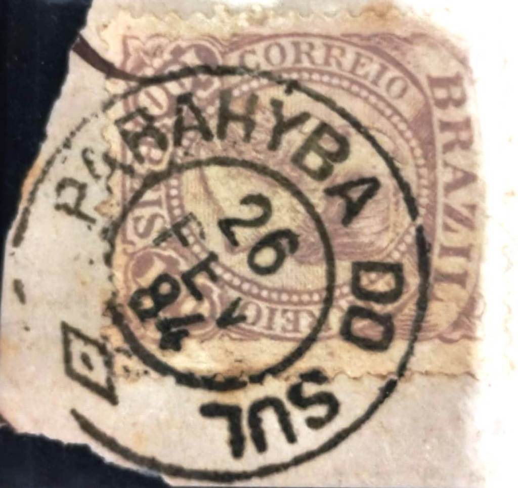
Villiers de l’Ile Adam: Carta (…) da Provincia do Piauhy, 1850
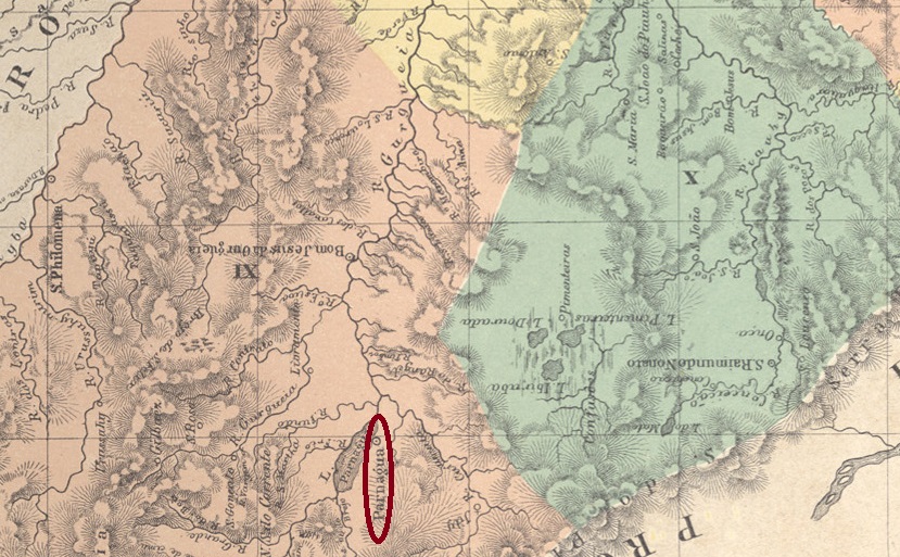
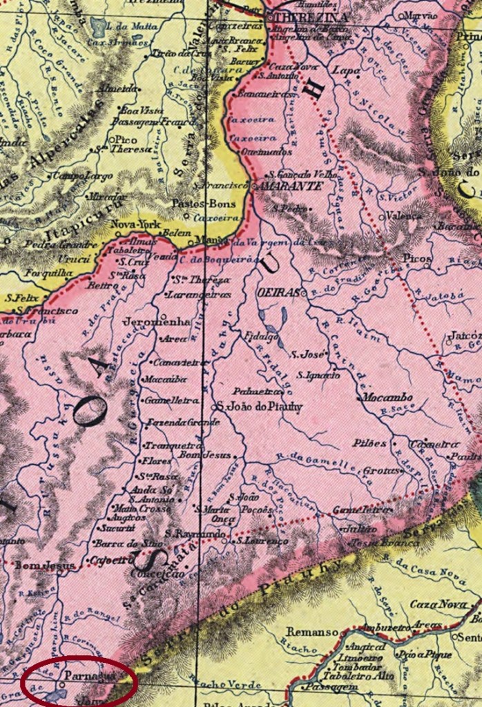
Alternative spelling: Parnaguá
This settlement has been documented since 1698. It was located on the eastern shore of Lake Parnaguá, 800 kilometres south of what would later become the provincial capital of Teresina. In 1755, it became the Freguesia de Nossa Senhora do Livramento do Paranaguá and in June 1761, it became a vila. It was then downgraded twice as a district in the municipality of Correntes: in June 1896 and June 1931. It regained its municipality status in July 1897 and again in June 1935, now spelled Parnaguá.
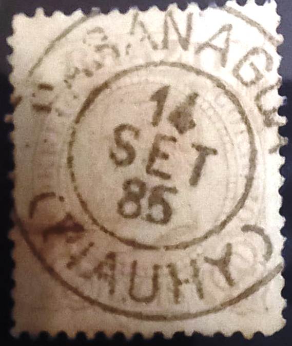
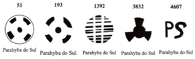
According to Nova Monteiro in Administrações e Agencias Postaes do Brasil Imperio (Brasil Filatelico/RJ, 1934–1935; reprinted by SPP 1994–1999), there had been a post office there since October 1830. A second agency was registered in 1877 in the directory of imperial post offices (Tabella das Agencias do Correio do Imperio, Rio de Janeiro, 1885). The only imperial postmark to date is PPI-0105b (Fuad Ferreira Fo. collection).
PPI-0105b (FF) 1885-1889Atlas do Imperio do Brasil, 1868
Outra grafia: Parnaguá
Esta povoação é mencionada desde 1698. Ela ficava na margem leste do Lago Parnaguá, 800 quilômetros ao sul da futura capital provincial Teresina. Em 1755, tornou-se a Freguesia de Nossa Senhora do Livramento do Paranaguá e, em junho de 1761, a Vila. Depois disso, foi rebaixada duas vezes a distrito no município de Correntes: em junho de 1896 e em junho de 1931. Recebeu o status de município em julho de 1897 e novamente em junho de 1935, então escrita Parnaguá.
De acordo com Nova Monteiro em Administrações e Agências Postais do Brasil Império (Brasil Filatélico/RJ, 1934–1935; reimpressão SPP 1994–1999), havia uma agência dos correios no local desde outubro de 1830. Uma segunda criação foi registrada em 1877 na Tabella das Agencias do Correio do Imperio (Rio de Janeiro, 1885). O único carimbo postal imperial conhecido até o momento é o PPI-0105b (Coleção Fuad Ferreira Fo.).
PPI-0105b (FF) 1885-1889Carta da Republica dos Estados Unidos do Brazil, 1892
Andere Schreibweise: Parnaguá
Diese Siedlung ist seit 1698 überliefert. Sie lag am Ostufer des Parnaguá-Sees, 800 Kilometer südlich der späteren Provinzhauptstadt Teresina. Im Jahr 1755 wurde sie zur Freguesia de Nossa Senhora do Livramento do Paranaguá und im Juni 1761 zur Vila. Danach wurde sie zweimal als Distrito im Município de Correntes degradiert: im Juni 1896 und im Juni 1931. Sie erhielt den Município-Status im Juli 1897 und im Juni 1935 erneut, nun Parnaguá geschrieben.
Laut Nova Monteiro in Administrações e Agencias Postaes do Brasil Imperio (Brasil Filatelico/RJ, 1934–1935; Nachdruck SPP 1994–1999) gab es dort seit Oktober 1830 ein Postamt. Eine zweite Agentur wurde 1877 im Verzeichnis der kaiserlichen Postämter (Tabella das Agencias do Correio do Imperio, Rio de Janeiro, 1885) registriert. Der bisher einzige kaiserliche Poststempel ist PPI-0105b (Sammlung Fuad Ferreira Fo.)
Villiers de l’Ile Adam: Carta (…) da Provincia de São Paulo, 1847
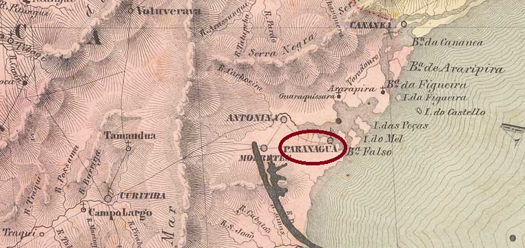
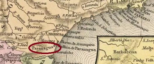
The Freguesia de N. Sra. do Rocio/Rosário de Paranaguá has been documented since 1647. It was located on the southern shore of Paranaguá Bay, 90 kilometres east of what would later become the provincial capital of Curitiba. In July 1648, it was elevated to the status of a vila and was even the seat of the Capitania de Paranaguá from 1660 to around 1710, before being assigned to the Capitania de São Paulo. In February 1842, it was designated a city, which was located in the province of Paraná from July 1854 onwards.
According to Nova Monteiro in Administrações e Agencias Postaes do Brasil Imperio (Brasil Filatelico/RJ, 1934–1935; reprinted by SPP 1994–1999), there had been a post office there since April 1828. However, philatelist Mário Celso Orsi Jr. gives a date that is exactly one year later, which could be a transcription error.
The oldest postmark to date is PPR-0150a, which also occurs in sepia and was given the code number P-SP-27 in the RHM catalogue:
PPR-0150a (RK – RHM P-SP-27) 1837-1841
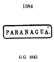
This was followed by PPR-0150b, which was given the number 1384 by P. Ayres in Catálogo de Carimbos Brasil-Império (S. Paulo, 1937, 1942):
PPR-0150b (P.A. 1384, RHM P-SP-28) 1837-1873
This was followed by PPR-0150c, also recorded by P. Ayres, this time with the number 1618:
PPR-0150c (P.A. 1618) 1854-1867
This was followed by the French type PPR-0150d, also listed by P. Ayres:
PPR-0150d (P.A. p. 118) 1867-1888
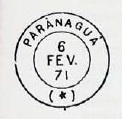
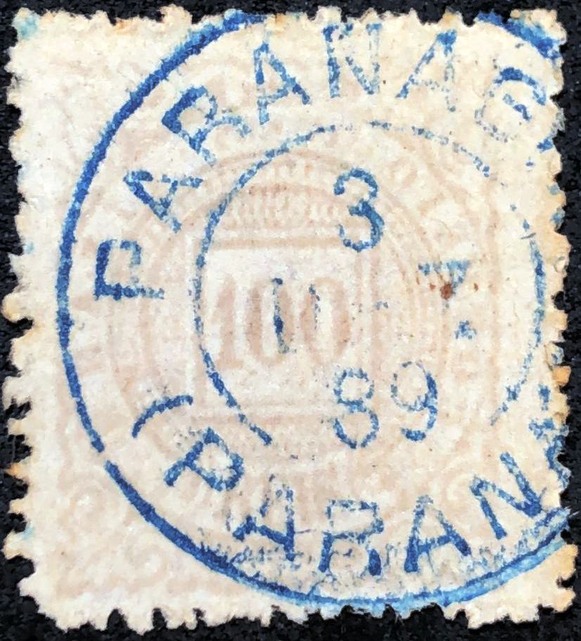
Shortly afterwards, PPR-0150e appeared, which is mostly found in blue:
PPR-0150e (P.A. 1546) 1873-1877
The following PPR-0150f also comes in blue and violet:
PPR-0150f (P.A. p. 122) 1878-1896
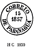
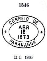
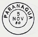
At the end of the Empire, PPR-0150g finally appeared, also in blue (fig. Luiz C. Fritzen):
PPR-0150g (LCF) 1888-1899
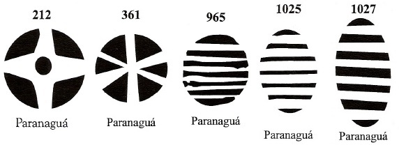
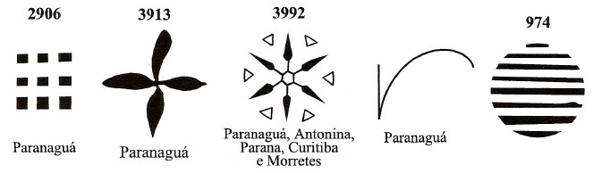
James Dingler and Klerman W. Lopes have listed 10 mute postmarks from Paranaguá in Mute Cancellations of the Brazil Empire/ Carimbos Mudos do Brasil Império (Brazil Philatelic Association, Rio de Janeiro, 2000):
BPA 212 (1876-1877ff) – 361 (1876) – 965 (1869) – 1025 (P.A. 364, 1869-1896) – 1027 (1877-1882)BPA 2906 – 3913 (P.A. 143, 1873-1878ff) – 3992 (P.A. 783, 1866ff-1876, also in violet) – 4364 (P.A. 479, 1866ff) – 974 (P.A. 370, 1866ff)Samuel A. Mitchell: Map of the Brazil, 1854
A Freguesia de N. Sra. do Rocio/Rosário de Paranaguá foi mencionada desde 1647. Situava-se na margem sul da baía de Paranaguá, 90 quilômetros a leste da futura capital provincial, Curitiba. Em julho de 1648, foi elevada à categoria de vila e, de 1660 a cerca de 1710, foi sede da Capitania de Paranaguá, antes de ser atribuída à Capitania de São Paulo. Em fevereiro de 1842, foi nomeada cidade, passando a fazer parte da província do Paraná a partir de julho de 1854.
De acordo com Nova Monteiro em Administrações e Agencias Postaes do Brasil Imperio (Brasil Filatelico/RJ, 1934–1935; reimpressão SPP 1994–1999), havia uma agência dos correios no local desde abril de 1828. O filatelista Mário Celso Orsi Jr., no entanto, menciona uma data exatamente um ano depois, o que pode ser um erro de transcrição.
O carimbo postal mais antigo até agora é o PPR-0150a, que também aparece em sépia e recebeu o código P-SP-27 no catálogo RHM:
PPR-0150a (RK – RHM P-SP-27) 1837-1841
Seguiu-se o PPR-0150b, que recebeu o número 1384 de P. Ayres no Catálogo de Carimbos Brasil-Império (São Paulo, 1937, 1942):
PPR-0150b (P.A. 1384, RHM P-SP-28) 1837-1873
Depois veio o PPR-0150c, também registrado por P. Ayres, desta vez com o número 1618:
PPR-0150c (P.A. 1618) 1854-1867
Seguiu-se o tipo francês PPR-0150d, também listado por P. Ayres:
PPR-0150d (P.A. p. 118) 1867-1888
Pouco depois, surgiu o PPR-0150e, que aparece principalmente em azul:
PPR-0150e (P.A. 1546) 1873-1877
O seguinte PPR-0150f também aparece em azul e violeta:
PPR-0150f (P.A. p. 122) 1878-1896
No final do Império, surgiu finalmente o PPR-0150g, também em azul (fig. Luiz C. Fritzen):
PPR-0150g (LCF) 1888-1899
James Dingler e Klerman W. Lopes listaram em Mute Cancellations of the Brazil Empire/ Carimbos Mudos do Brasil Império (Clube Filatélico do Brasil, Rio de Janeiro, 2000) 10 carimbos postais mudos de Paranaguá:
Die Freguesia de N. Sra. do Rocio/Rosário de Paranaguá ist seit 1647 überliefert. Sie lag am Südufer der Paranaguá-Bucht, 90 Kilometer östlich der späteren Provinzhauptstadt Curitiba. Im Juli 1648 wurde sie zur Vila erhoben und war von 1660 bis ca. 1710 sogar Sitz der Capitania de Paranaguá, bevor sie der Capitania de São Paulo zugesprochen wurde. Im Februar 1842 wurde sie zur Stadt ernannt, die ab Juli 1854 in der Provinz Paraná lag.
Laut Nova Monteiro in Administrações e Agencias Postaes do Brasil Imperio (Brasil Filatelico/RJ, 1934–1935; Nachdruck SPP 1994–1999) gab es dort seit April 1828 ein Postamt. Der Philatelist Mário Celso Orsi Jr. nennt jedoch ein Datum, das genau ein Jahr später liegt, was ein Abschreibfehler sein könnte.
Der bisher älteste Poststempel ist PPR-0150a, der auch in Sepia vorkommt und im RHM-Katalog die Code-Nr. P-SP-27 erhielt:
PPR-0150a (RK – RHM P-SP-27) 1837-1841
Es folgte PPR-0150b , der von P. Ayres in Catálogo de Carimbos Brasil-Império (São Paulo, 1937, 1942) die Nr. 1384 bekam:
PPR-0150b (P.A. 1384, RHM P-SP-28) 1837-1873
Danach kam PPR-0150c, ebenfalls von P. Ayres erfasst, diesmal mit der Nr. 1618:
PPR-0150c (P.A. 1618) 1854-1867
Es folgte der französische Typ PPR-0150d, auch von P. Ayres aufgeführt:
PPR-0150d (P.A. S. 118) 1867-1888
Kurz darauf erschien PPR-0150e, der meistens in Blau vorkommt:
PPR-0150e (P.A. 1546) 1873-1877
Der folgende PPR-0150f kommt ebenfalls in Blau und Violett vor:
PPR-0150f (P.A. S. 122) 1878-1896
Am Ende des Kaiserreichs erschien schließlich PPR-0150g, auch in Blau (Abb. Luiz C. Fritzen):
PPR-0150g (LCF) 1888-1899
James Dingler und Klerman W. Lopes haben in Mute Cancellations of the Brazil Empire/ Carimbos Mudos do Brasil Império (Brazil Philatelic Association, Rio de Janeiro, 2000) 10 stumme Poststempel aus Paranaguá aufgeführt:
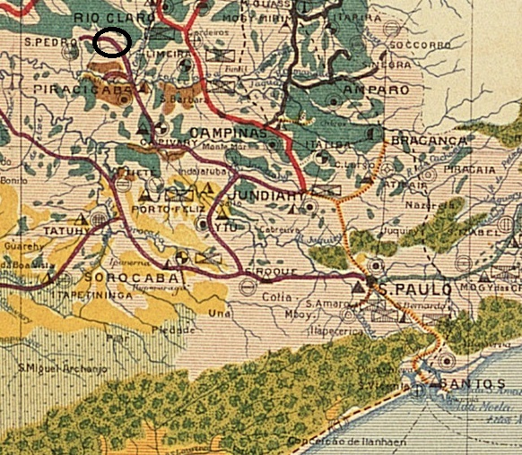
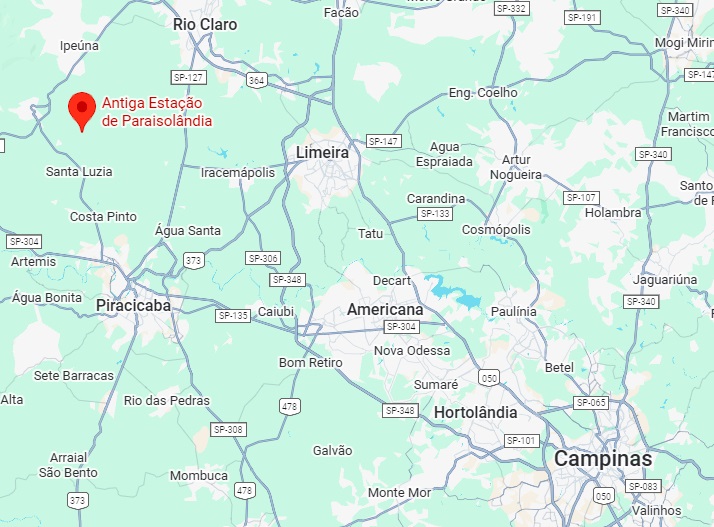
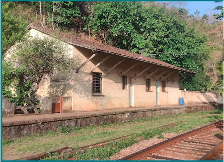
Paraíso Station was opened in 1888 by the E. F. Ytuana railway company. It was located on the north bank of the Ribeirão Fregadoli in the municipality of Piracicaba, 180 kilometres northwest of the provincial capital São Paulo. The railway line was transferred to Cia. União Sorocabana e Ytuana in 1892 and to Sorocabana Railway in 1907. From 1919 until its closure in 1966, it belonged to E.F. Sorocabana (estacoesferroviarias.com.br). Today, the tracks have been removed and the station building appears to be used as a residential building.
In 1980 (photo: José P. Siqueira Jr., on estacoesferroviarias.com.br)In June 2025 (Google Street View)
Since December 1953, the station has been located in the município de Charqueada and, since February 1959, in its distrito de Paraisolândia.
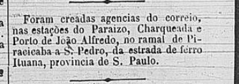
According to reports in the Rio press, there had been a post office at the station since March 1888:
Cidade do Rio, 09.03.1888
The imperial postmark is PSP-0865a (image from the internet):
PSP-0865a (EB) 1888ffEstado de São PAulo, 1910
Outros nomes: Paraisolândia (1959)
A estação Paraíso foi inaugurada em 1888 pela E. F. Ytuana. Localizava-se na margem norte do Ribeirão Fregadoli, no município de Piracicaba, 180 quilômetros a noroeste da capital do estado, São Paulo. A linha ferroviária passou para a Cia. União Sorocabana e Ytuana em 1892 e para a Sorocabana Railway em 1907. De 1919 até o fechamento em 1966, pertenceu à E.F. Sorocabana (estacoesferroviarias.com.br). Hoje, os trilhos foram removidos e o prédio da estação parece ser usado como residência.
Em 1980 (Foto: José P. Siqueira Jr., em estacoesferroviarias.com.br)Em junho de 2025 (Google Street View)
Desde dezembro de 1953, a estação ferroviária está localizada no município de Charqueada e, desde fevereiro de 1959, no seu distrito de Paraisolândia.
Conforme informou a imprensa do Rio, foi criada uma agência dos correios na estação em março de 1888:
Cidade do Rio, 09.03.1888
O carimbo postal imperial é PSP-0865a (fig. da Internet):
PSP-0865a (EB) 1888ffGoogle Maps
Andere Namen: Paraisolândia (1959)
Der Bahnhof Paraíso wurde 1888 von der Eisenbahngesellschaft E. F. Ytuana eröffnet. Er lag am Nordufer des Ribeirão Fregadoli im Munizip Piracicaba, 180 Kilometer nordwestlich der Provinzhauptstadt São Paulo. Die Bahnlinie wechselte 1892 zur Cia. União Sorocabana e Ytuana und 1907 zur Sorocabana Railway. Von 1919 bis zur Stilllegung im Jahr 1966 gehörte sie der E.F. Sorocabana (estacoesferroviarias.com.br). Heute sind die Gleise entfernt und das Bahnhofsgebäude scheint als Wohnhaus genutzt zu werden.
Im Jahr 1980 (Foto: José P. Siqueira Jr., auf estacoesferroviarias.com.br)Im Juni 2025 (Google Street View)
Der Bahnhof liegt seit Dezember 1953 im Município de Charqueada und seit Februar 1959 im dessen Distrito de Paraisolândia.
Wie die Presse aus Rio mitteilte, gab es am Bahnhof ein Postamt seit März 1888:
Cidade do Rio, 09.03.1888
Der kaiserliche Poststempel ist PSP-0865a (Abb. aus dem Internet):
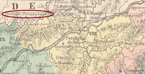
See also Registro do Parahybuna (RRJ-3930) – Mont-Serrat (MMG-1646)
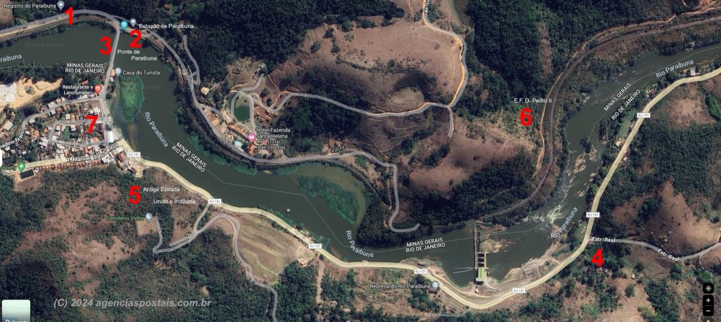
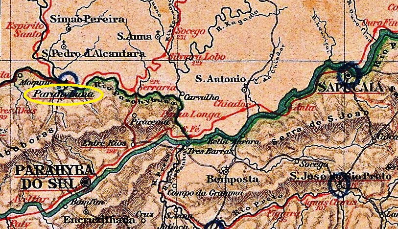
The Parahybuna (now spelled Paraibuna) is a river that rises in the mountains of the Zona da Mata in Minas Gerais. From there, it flows south to the border with Rio de Janeiro, where it joins the Rio Preto. It then continues along the border until it flows into the Parahyba (now Paraíba) do Sul near the city of Três Rios.
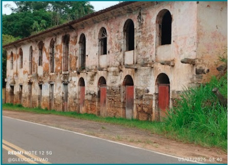
The Registro do Parahybuna was built at the beginning of the 18th century as a tax or toll station on the north bank, i.e. in Minas Gerais, and enabled a new trade route (Caminho Novo) between Minas Gerais and Rio de Janeiro. It was located 250 kilometres south of the provincial capital Ouro Preto, but was administered from Rio de Janeiro. The ruins of this building still exist today – together with a bridge built in the 19th century – and are now tourist attractions.
In January 2026 (photo: Gleuço Galvão, on Google Maps)
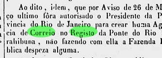
According to the imperial official press, there had been a post office there since March 1840:
Correio Official, 01.05.1840
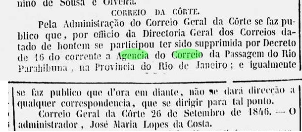
This was closed in September 1846:
Gazeta Official, 30.09.1846
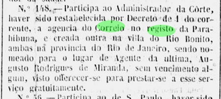
It reopened in 1847:
Gazeta Official, 22.06.1847
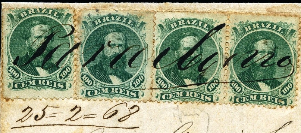
In the following period, the agency was closed intermittently and was occasionally renamed Ponte do Paraibuna. From the first period, only handwritten cancellations are known to date, the exact origin of which cannot be determined as they could also have come from the Parahibuna post office in the province of São Paulo (PSP-0860).
1846 (Silvio A. Canani collection)1844ff-1850ff (illustration by R. Koester, in Carimbologia XXIX)1866ff (illustration by Koester, op. cit.)1867-1868 (illustration by Felipe Piccinini)
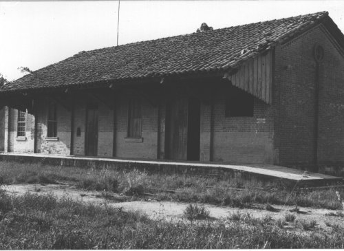
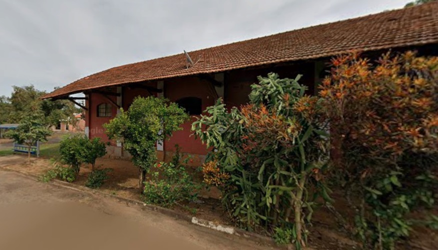
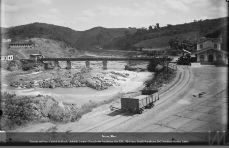
The situation became more complicated in September 1874 with the construction of the Parahybuna railway station of the E. F. D. Pedro II right next to the Registro. From 1875 onwards, the station also had its own post office, which presumably operated in parallel with the post office agency at the Registro for several years. The railway line was transferred to the E.F. Central do Brasil in 1889 and belonged to Rede Ferroviária Federal S.A. from 1975 until it was decommissioned in 1996 (estacoesferroviarias.com.br). Today, the tracks are still in place and the station building is to be used for residential purposes.
Around 1884 (Photo: Marc Ferrez, Instituto Moreira Salles)In October 2024 (photo Edesio Souza, on Google Maps)
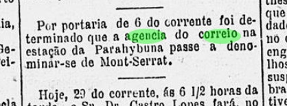
Originally, Parahybuna station was located in the municipality of Juiz de Fora. From September 1923, it belonged to the municipality of Matias Barbosa. Since March 1963, the station and the Registro area have been part of the municipality of Simão Pereira. In November 1886, the Parahybuna station post office was renamed Monte Serrat.
Gazeta de Noticias, 29 November 1886
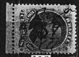
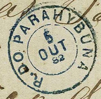
The only surviving Registro postmark, RRJ-3930a (fig. Corinphila Auctions), presents a mystery:
RRJ-3930a (CO) 1882-1883
The first letter was originally a P (for Ponte?) and was changed by hand to an R (for Registro).
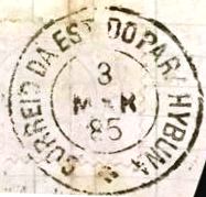
The only station postmark known to date is PMG-3931a (illustration from the internet):
PMG-3931a (EB) 1884-1886agenciaspostais.com.br
Outros nomes: Ponte do Parahybuna
Veja também Registro do Parahybuna (RRJ-3930) – Mont-Serrat (MMG-1646)
O Paraibuna é um rio que nasce nas montanhas da Zona da Mata Mineira. De lá, segue para o sul até a divisa com o Rio de Janeiro, onde se junta ao Rio Preto. Continua então ao longo da divisa até desaguar no Paraíba do Sul, próximo à cidade de Três Rios.
O Registro do Paraibuna foi construído no início do século XVIII como uma estação tributária ou pedágio na margem norte do rio, ou seja, em Minas Gerais, e possibilitou uma nova rota comercial (Caminho Novo) entre Minas e o Rio de Janeiro. Ele ficava localizado 250 quilômetros ao sul da capital provincial Ouro Preto, mas era administrado a partir do Rio de Janeiro. As ruínas desse edifício ainda existem hoje – juntamente com uma ponte construída no século XIX – e são agora atrações turísticas.
Em janeiro de 2026 (foto: Gleuço Galvão, no Google Maps)
De acordo com a imprensa oficial imperial, havia uma agência dos correios no local desde março de 1840:
Correio Oficial, 01.05.1840
Esta foi fechada em setembro de 1846:
Gazeta Oficial, 30.09.1846
Mas reabriu em 1847:
Gazeta Oficial, 22.06.1847
No período seguinte, a agência foi fechada intermitentemente e ocasionalmente renomeada como Ponte do Paraibuna. Do primeiro período, só se conhecem até hoje cancelamentos manuscritos, cuja origem exata não pode ser definitivamente confirmada, pois também poderiam ter vindo da agência dos correios de Paraibuna, na província de São Paulo (PSP-0860).
1846 (coleção Silvio A. Canani)1844ff-1850ff (ilustração de R. Koester, em Carimbologia XXIX)1866ff (ilustração de Koester, op. cit.)1867-1868 (ilustração de Felipe Piccinini)
A situação se complicou em setembro de 1874 com a construção da estação ferroviária de Paraibuna da E. F. D. Pedro II, bem ao lado do Registro. A partir de 1875, a estação também passou a ter sua própria agência dos correios, que provavelmente funcionou em paralelo com a agência dos correios do Registro por vários anos. A linha ferroviária foi transferida para a E.F. Central do Brasil em 1889 e pertenceu à Rede Ferroviária Federal S.A. de 1975 até ser desativada em 1996 (estacoesferroviarias.com.br). Hoje, os trilhos ainda estão lá e o prédio da estação seria usado para fins residenciais.
Ca. 1884 (Foto: Marc Ferrez, Instituto Moreira Salles)Em outubro de 2024 (foto Edesio Souza, no Google Maps)
Originalmente, a estação de Parahybuna estava localizada no município de Juiz de Fora. A partir de setembro de 1923, passou a pertencer ao município de Matias Barbosa. Desde março de 1963, a estação e a área do Registro fazem parte do município de Simão Pereira. Em novembro de 1886, a agência dos correios da estação de Parahybuna foi renomeada para Monte Serrat.
Gazeta de Notícias, 29 de novembro de 1886
O único carimbo postal imperial do Registro até agora, RRJ-3930a (fig. Corinphila Auctions), apresenta um mistério:
RRJ-3930a (CO) 1882-1883
A primeira letra era originalmente um P (de Ponte?) e foi alterada à mão para um R (de Registro).
O único carimbo postal da estação conhecido até o momento é o PMG-3931a (ilustração da internet):
PMG-3931a (EB) 1884-1886Almanak Laemmert, 1892
Andere Namen: Ponte do Parahybuna
Siehe auch Registro do Parahybuna (RRJ-3930) – Mont-Serrat (MMG-1646)
Der Parahybuna (heute Paraibuna geschrieben) ist ein Fluss, der im Gebirge der Zona da Mata in Minas Gerais entspringt. Von dort fließt er in Richtung Süden bis zur Grenze zu Rio de Janeiro, wo er den Rio Preto aufnimmt. Anschließend fließt er entlang der Grenze weiter, bis er in den Parahyba (heute Paraíba) do Sul nahe der Stadt Três Rios mündet.
Der Registro do Parahybuna wurde zu Beginn des 18. Jahrhunderts als Steuer- oder Mautstelle am Nordufer, also in Minas Gerais, gebaut und ermöglichte einen neuen Handelsweg (Caminho Novo) zwischen Minas Gerais und Rio de Janeiro. Er lag 250 Kilometer südlich der Provinzhauptstadt Ouro Preto, wurde jedoch von Rio de Janeiro aus verwaltet. Von diesem Bau existieren heute noch die Ruinen – zusammen mit einer im 19. Jahrhundert entstandenen Brücke – die heute touristische Attraktionen sind.
Im Januar 2026 (Foto: Gleuço Galvão, auf Google Maps)
Wie aus der kaiserlichen Amtspresse hervorgeht, gab es dort seit März 1840 ein Postamt:
Correio Official, 01.05.1840
Dieses wurde im September 1846 geschlossen:
Gazeta Official, 30.09.1846
Eine Wiedereröffnung fand 1847 statt:
Gazeta Official, 22.06.1847
In der Folgezeit war die Agentur zwischendurch geschlossen und wurde gelegentlich in Ponte do Paraibuna umbenannt. Aus der ersten Periode sind bisher lediglich handschriftliche Entwertungen bekannt, deren genaue Zuordnung nicht möglich ist, da sie auch aus dem Postamt Parahibuna in der Provinz São Paulo (PSP-0860) stammen könnten.
1846 (Samml. Silvio A. Canani)1844ff-1850ff (Abb. R. Koester, in Carimbologia XXIX)1866ff (Abb. Koester, op. cit.)1867-1868 (Abb. Felipe Piccinini)
Die Lage wurde im September 1874 durch den Bau des Bahnhofs Parahybuna der E. F. D. Pedro II gleich neben dem Registro komplizierter. Ab 1875 verfügte der Bahnhof auch über ein eigenes Postamt, das vermutlich einige Jahre parallel zur Postagentur am Registro in Betrieb war. Die Bahnlinie ging 1889 an die E.F. Central do Brasil über und gehörte von 1975 bis zur Stilllegung im Jahr 1996 zur Rede Ferroviária Federal S.A. (estacoesferroviarias.com.br). Heute sind die Gleise noch vorhanden und das Bahnhofsgebäude soll zu Wohnzwecken genutzt werden.
Um 1884 (Foto: Marc Ferrez, Instituto Moreira Salles)Im Oktober 2024 (Foto Edesio Souza, auf Google Maps)
Ursprünglich lag der Bahnhof Parahybuna noch im Gebiet des Município de Juiz de Fora. Ab September 1923 gehörte er zum Município de Matias Barbosa. Seit März 1963 liegen der Bahnhof und das Gebiet Registro im Município de Simão Pereira. Im November 1886 wurde das Bahnhofspostamt Parahybuna in Monte Serrat umbenannt.
Gazeta de Noticias, 29.11.1886
Der einzige überlieferte Registro-Stempel RRJ-3930a (Abb. Corinphila Auktionen) bringt gleich einen Rätsel mit:
RRJ-3930a (CO) 1882-1883
Der erste Buchstabe war ursprünglich ein P (für Ponte?), und wurde per Hand zu einem R (für Registro) geändert.
Der bisher einzige Bahnhofs-Poststempel ist PMG-3931a (Abb. aus dem Internet):
Villiers de l’Ile Adam: Carta (…) da Provincia de São Paulo, 1847
Other spellings: Parahybuna, Paraibuna
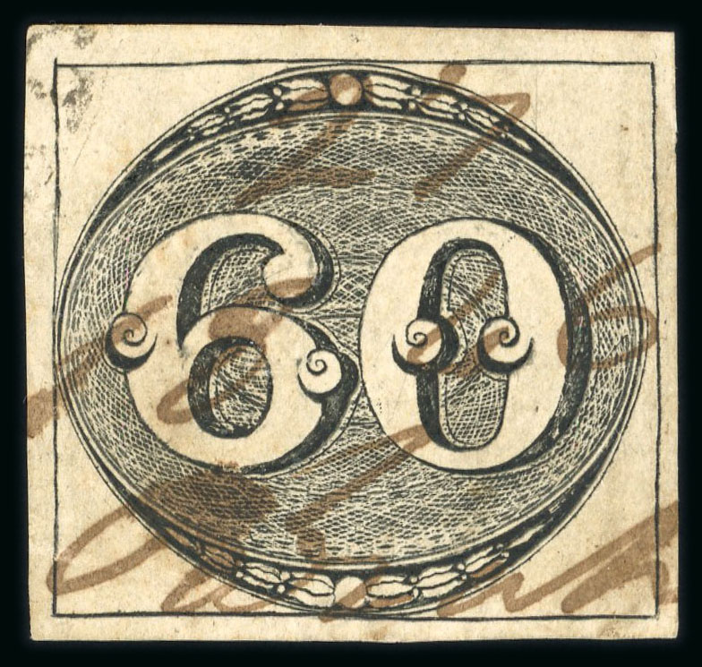
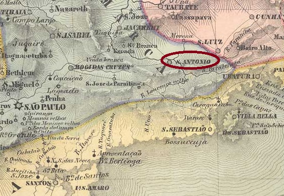
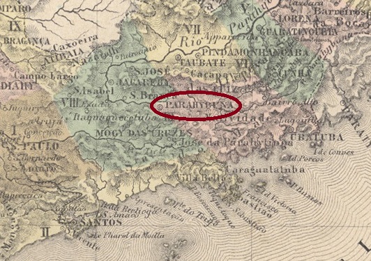
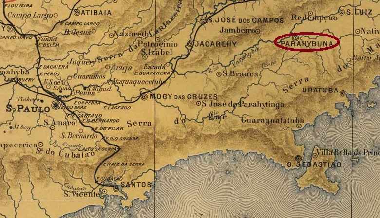
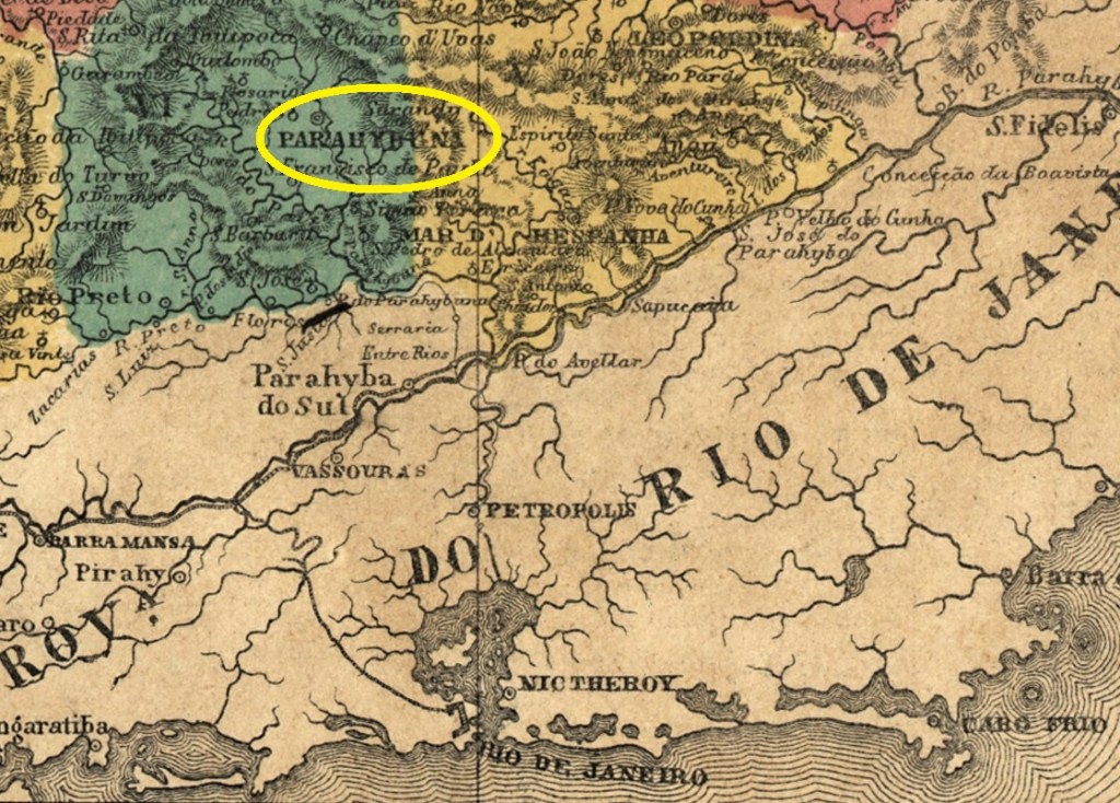
The Freguesia de Sto. Antonio do Paraibuna was founded in August 1812 and belonged to the Vila de Jacareí. The settlement was located on the west bank of the Paraíba do Sul, 120 kilometres east of what would later become the provincial capital of São Paulo. In July 1832, it became a vila and in May 1857, it finally became a city.
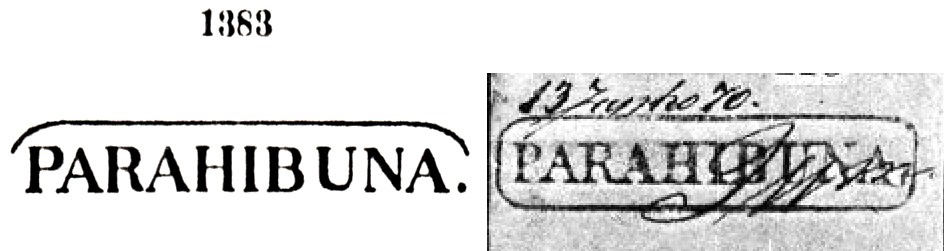
According to philatelist Mário Celso Orsi Jr., the local post office was created in May 1844. The oldest postmark is PSP-0860a, which also appears in blue and red. In P. Ayres’ ‘Catálogo de Carimbos Brasil-Império’ (São Paulo, 1937, 1942), it was given the number 1383. However, its illustration was corrected by R. Koester (Carimbologia XXIX):
PSP-0860a (P.A. 1383 / RK) 1844-1870
This was followed by the double circle PSP-0860b (illustration by Carlos A. Balata):
PSP-0860b (CB) 1877-1882
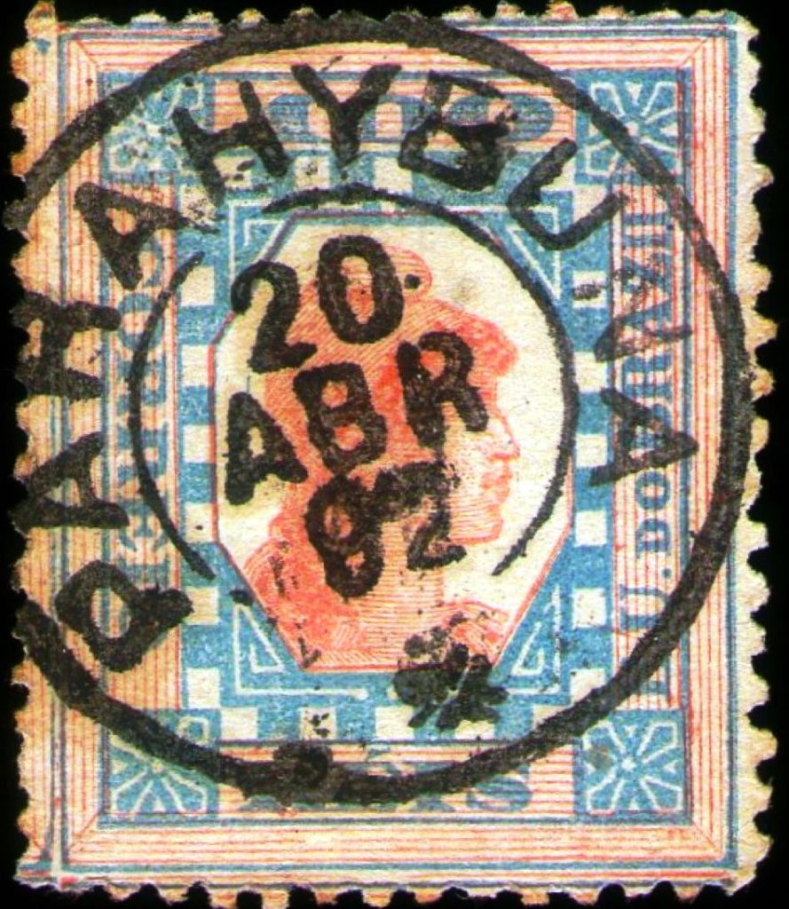
Then came the French type PSP-0860c (illustration from the internet), which was also recorded by P. Ayres (op. cit.):
PSP-0860c (EB – P.A. p. 117) 1883-1889
At the end of the century, PSP-0860d (Fig. Claudio Coelho) also appeared:
PSP-0860d (CC) 1892-1905Atlas do Imperio do Brasil, 1868
Outras grafias: Parahybuna, Paraibuna
A Freguesia de Sto. Antonio do Paraibuna foi fundada em agosto de 1812 e pertencia à Vila de Jacareí. O povoado ficava na margem oeste do Paraíba do Sul, 120 quilômetros a leste da futura capital do estado, São Paulo. Em julho de 1832, tornou-se vila e, em maio de 1857, finalmente cidade.
De acordo com o filatelista Mário Celso Orsi Jr., a agência dos correios local foi criada em maio de 1844. O carimbo postal mais antigo é o PSP-0860a, que também existe em azul e vermelho. No “Catálogo de Carimbos Brasil-Império” (São Paulo, 1937, 1942), ele recebeu o número 1383. No entanto, sua ilustração foi corrigida por R. Koester (Carimbologia XXIX):
PSP-0860a (P.A. 1383 / RK) 1844-1870
Seguiu-se o círculo duplo PSP-0860b (fig. Carlos A. Balata):
PSP-0860b (CB) 1877-1882
Depois veio o tipo francês PSP-0860c (fig. da Internet), que também foi registrado por P. Ayres (op. cit.):
PSP-0860c (EB – P.A. p. 117) 1883-1889
No final do século, surgiu também o PSP-0860d (fig. Claudio Coelho):
PSP-0860d (CC) 1892-1905J.M. Ribeiro Lisboa: Provincia de São Paulo, 1884
Andere Schreibweisen: Parahybuna, Paraibuna
Die Freguesia de Sto. Antonio do Paraibuna wurde im August 1812 gegründet und gehörte zur Vila de Jacareí. Die Siedlung lag am Westufer des Paraíba do Sul, 120 Kilometer östlich der späteren Provinzhauptstadt São Paulo. Im Juli 1832 wurde sie zur Vila und im Mai 1857 schließlich zur Stadt.
Laut dem Philatelisten Mário Celso Orsi Jr. wurde das örtliche Postamt im Mai 1844 ins Leben gerufen. Der älteste Poststempel ist PSP-0860a, der auch in Blau und Rot vorkommt. Im P. Ayres’ „Catálogo de Carimbos Brasil-Império” (São Paulo, 1937, 1942) erhielt er die Nr. 1383. Seine Abbildung konnte jedoch durch R. Koester (Carimbologia XXIX) korrigiert werden:
PSP-0860a (P.A. 1383 / RK) 1844-1870
Es folgte der Doppelkreis PSP-0860b (Abb. Carlos A. Balata):
PSP-0860b (CB) 1877-1882
Danach kam der französische Typ PSP-0860c (Abb. aus dem Internet) der auch von P. Ayres (op. cit.) erfasst wurde:
PSP-0860c (EB – P.A. S. 117) 1883-1889
Am Ende des Jahrhunderts erschien auch PSP-0860d (Abb. Claudio Coelho):
Villiers de l’Ile Adam: Carta (…) da Provincia de Minas Geraes, 1849
Other names: Santo Antonio do Parahybuna
See also Juiz de Fora (JMG-1445)
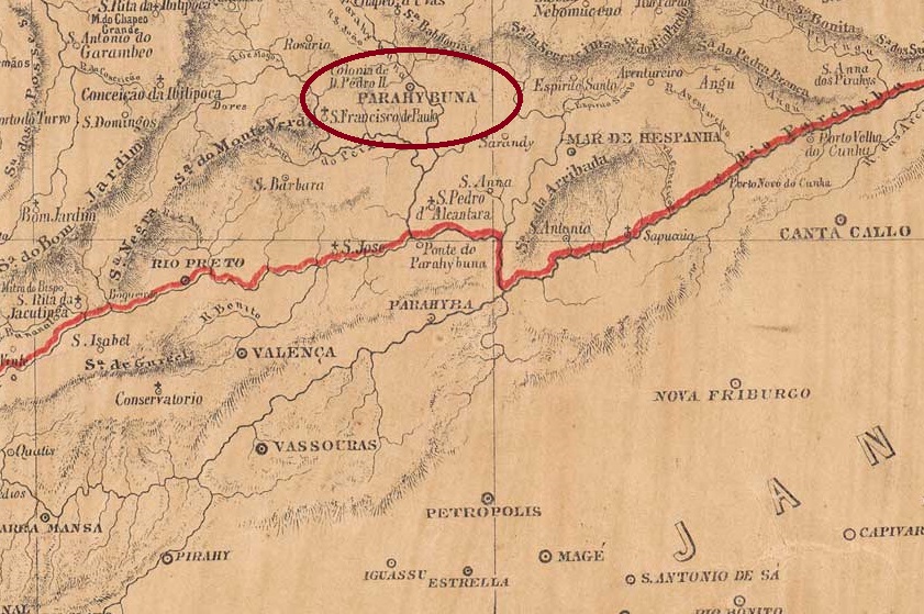
Since March 1781, a Fazenda do Juiz de Fora existed on the west bank of the Paraibuna around Vila de S. João d’El Rei, 230 kilometres south of the later provincial capital of Ouro Preto. In March 1844, the chapel of Sto. Antonio do Parahybuna was consecrated here, which was assigned to the Vila de Santo Antonio do Parahybuna in May 1850. Parahybuna was elevated to the status of town in May 1856 and in December 1865 the original name was changed back as Município de Juiz de Fora.
In March 1851, it was decided to establish a local post office, as reported in the Rio de Janeiro press:
Diario do Rio de Janeiro, 15/04/1851
The first postmarks still bear the place name Parahybuna. The oldest to date is PMG-3925b (fig. R. Koester, in Carimbologia XXV):
PMG-3925b (RK) 1863
Two French type postmarks followed. The first is PMG-3925c (fig. Koester, op. cit.):
PMG-3925c (RK) 1868
The second, slightly modified, is PMG-3925d (fig. Koester):
PMG-3925d (RK) 1871-1882
For postmarks with the place name Juiz de Fora (from around 1877), see JMG-1445.
Atlas do Imperio do Brasil, 1868
Outros nomes: Santo Antônio do Parahybuna
Veja também Juiz de Fora (JMG-1445)
Desde março de 1781, existia uma Fazenda do Juiz de Fora na margem oeste do Paraibuna, na área da Vila de S. João d’El Rei, 230 quilômetros ao sul da futura capital da província, Ouro Preto. Em março de 1844, a capela de Sto. Antônio do Parahybuna foi consagrada nesse local, a qual foi designada para a Vila de Santo Antônio do Parahybuna em maio de 1850. Parahybuna foi elevada a cidade em maio de 1856 e, em dezembro de 1865, o nome original retornou como Município de Juiz de Fora.
Em março de 1851, foi criada uma agência postal local, conforme relatado na imprensa do Rio de Janeiro:
Diario do Rio de Janeiro, 15/04/1851
Os primeiros carimbos postais ainda trazem o topônimo Parahybuna. O mais antigo até o momento é o PMG-3925b (fig. R. Koester, em Carimbologia XXV):
PMG-3925b (RK) 1863
Seguiram-se dois carimbos postais tipo francês. O primeiro é o PMG-3925c (fig. Koester, op. cit.):
PMG-3925c (RK) 1868
O segundo, ligeiramente modificado, é PMG-3925d (fig. Koester):
PMG-3925d (RK) 1871-1882
Para carimbos postais com o nome da cidade Juiz de Fora (a partir de aproximadamente 1877), consulte JMG-1445.
Provincia de Minas Geraes, 1873
Andere Namen: Santo Antonio do Parahybuna
Siehe auch Juiz de Fora (JMG-1445)
Seit März 1781 bestand eine Fazenda do Juiz de Fora am Westufer des Paraibuna im Gebiet von Vila de S. João d’El Rei, 230 km südlich der späteren Provinzhauptstadt Ouro Preto. Im März 1844 wurde hier die Kapelle Sto. Antonio do Parahybuna eingeweiht, die im Mai 1850 der Vila de Santo Antonio do Parahybuna zugeordnet wurde. Die Erhebung zur Stadt Parahybuna erfolgte im Mai 1856 und im Dezember 1865 wurde der ursprüngliche Ortsname wieder in Município de Juiz de Fora geändert.
Im März 1851 wurde die Einrichtung eines örtlichen Postamtes beschlossen, wie aus der Presse von Rio de Janeiro hervorgeht:
Diario do Rio de Janeiro, 15.04.1851
Die ersten Poststempel tragen noch den Ortsnamen Parahybuna. Der bisher älteste ist PMG-3925b (Abb. R. Koester, in Carimbologia XXV):
PMG-3925b (RK) 1863
Es folgten zwei französische Poststempel. Der erste ist PMG-3925c (Abb. Koester, op. cit.):
PMG-3925c (RK) 1868
Der zweite, leicht veränderte, ist PMG-3925d (Abb. Koester):
PMG-3925d (RK) 1871-1882
Für Poststempel mit dem Ortsnamen Juiz de Fora (ab ca. 1877) siehe JMG-1445.
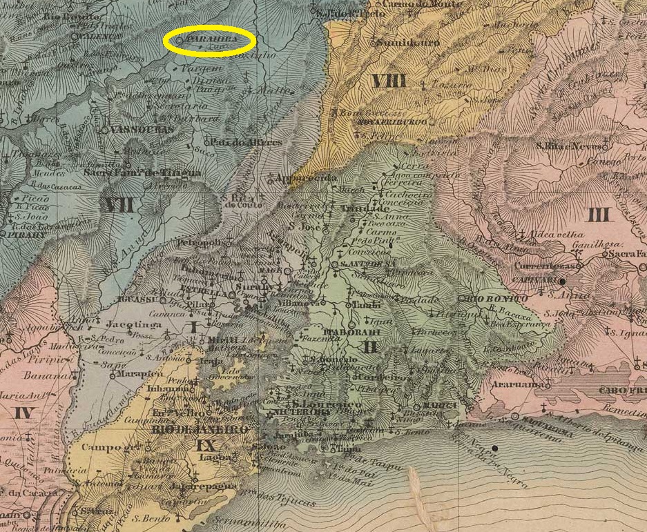
Villiers de l’Ile Adam: Carta (…) da Provincia do Rio de Janeiro, 1850
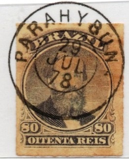
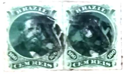
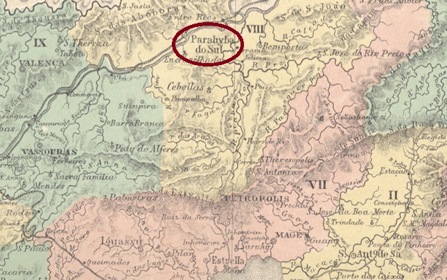
Other spellings: Parahiba/Paraíba do Sul
The locality was originally called Freguesia de S. Pedro e S. Paulo and was located on the south bank of the Paraíba do Sul River, 140 km north of the capital Rio de Janeiro. In January 1833, it became a vila and in December 1870 a town.
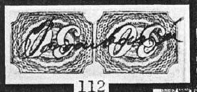
According to Nova Monteiro in Administrações e Agencias Postaes do Brasil Imperio (Brasil Filatelico/RJ, 1934–1935; reprinted by SPP 1994–1999), there had been a post office there since September 1832. The oldest postmark to date is PRJ-0750a. It also exists in red and orange. It was recorded by P. Ayres in ‘Catálogo de Carimbos Brasil-Império’ (São Paulo, 1937, 1942) under No. 1853 and in the RHM catalogue under P-RJ-23.
Around 1855, stamps were cancelled by hand, as shown in the illustration from R. Koester’s Carimbologia XXIX:
1855 (RK)
This was followed by the French-style postmark PRJ-0750b (Klerman Lopes collection):
PRJ-0750b (KL) 1867-1889
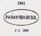
Then came the oval PRJ-0750c, which was given the number 1381 by P. Ayres (op. cit.):
PRJ-0750c (P.A. 1381) 1866-1871
A second French postmark – this time without hyphens in the place name – PRJ-0750d (image from the Fuad Ferreira Fo. collection) appeared shortly afterwards, also in blue:
PRJ-0750d (FF – MPT 396/400) 1871-1889
This was followed by the double circle PRJ-0750e (Marcio Duarte collection):
PRJ-0750e (MDu) 1877-1890ff
Then came the rare oval postmark PRJ-0750f (José A. Junges collection), which was also registered by P. Ayres:
PRJ-0750f (P.A. 1382 – JJ) 1883
At the end of the century, two more circular postmarks appeared. First, PRJ-0750g (Marcio Duarte collection), which also exists in dark purple:
PRJ-0750g (RK) 1884-1889
Then PRJ-0750h (illustration by Roberto Assef Jr.):
PRJ-0750h (RA) 1889-1897
James Dingler and Klerman W. Lopes listed five mute postmarks from Parahyba do Sul in Mute Cancellations of the Brazil Empire / Carimbos Mudos do Brasil Império (Brazil Philatelic Association, Rio de Janeiro, 2000):
Five additional mute cancels were found. The illustrations are from the Klerman Lopes collection, Felipe Piccinini, and the collections of Fuad Ferreira Fo, F. Monteiro, and José A. Junges:
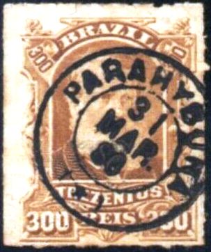
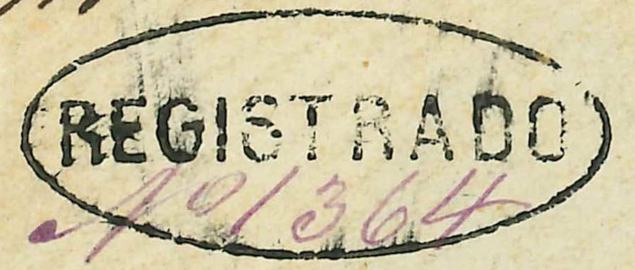
This registered postmark also comes from Parahyba do Sul (Fig. D. Feldman Auctions):
1873-1880 (DF)Colton & Colton: Provincia do Rio de Janeiro, 1866
Outras grafias: Parahiba/Paraíba do Sul
A localidade chamava-se originalmente Freguesia de S. Pedro e S. Paulo, ficava na margem sul do Paraíba do Sul e situava-se 140 km ao norte da capital Rio de Janeiro. Em janeiro de 1833, tornou-se vila e, em dezembro de 1870, cidade.
De acordo com Nova Monteiro em Administrações e Agências Postais do Brasil Império (Brasil Filatélico/RJ, 1934–1935; reimpressão SPP 1994–1999), havia uma agência dos correios no local desde setembro de 1832. O carimbo postal mais antigo até agora é o PRJ-0750a. Ele também ocorre em vermelho e laranja. Foi registrado tanto por P. Ayres em “Catálogo de Carimbos Brasil-Império” (São Paulo, 1937, 1942) sob o nº 1853 quanto no catálogo RHM sob P-RJ-23.
Por volta de 1855, os selos eram obliterados à mão, como mostra a ilustração de R. Koester em Carimbologia XXIX:
1855 (RK)
Seguiu-se o carimbo postal em tipo francês PRJ-0750b (Coleção Klerman Lopes):
PRJ-0750b (KL) 1867-1889
Depois veio o oval PRJ-0750c, que recebeu o número 1381 de P. Ayres (op. cit.):
PRJ-0750c (P.A. 1381) 1866-1871
Um segundo carimbo postal tipo francês – desta vez sem hífens no nome da localidade – PRJ-0750d (Coleção Fuad Ferreira Fo.) surgiu pouco tempo depois, também em azul:
PRJ-0750d (FF – MPT 396/400) 1871-1889
Seguiu-se o círculo duplo PRJ-0750e (coleção Marcio Duarte):
PRJ-0750e (MDu) 1877-1890ff
Depois veio o raro carimbo oval PRJ-0750f (coleção José A. Junges), que também foi registrado por P. Ayres:
PRJ-0750f (P.A. 1382 – JJ) 1883
No final do século, surgiram mais dois carimbos circulares. Primeiro, o PRJ-0750g (coleção Marcio Duarte), que também existe em roxo:
PRJ-0750g (RK) 1884-1889
Depois, o PRJ-0750h (fig. Roberto Assef Jr.):
PRJ-0750h (RA) 1889-1897
James Dingler e Klerman W. Lopes listaram 5 carimbos postais mudos de Parahyba do Sul em Mute Cancellations of the Brazil Empire / Carimbos Mudos do Brasil Império (Clube Filatélico do Brasil, Rio de Janeiro, 2000):
Foram encontrados mais cinco carimbos mudos. As imagens são da coleção Klerman Lopes, de Felipe Piccinini e das coleções Fuad Ferreira Fo, F. Monteiro e José A. Junges:
Este carimbo para registrados também é proveniente de Parahyba do Sul (fig. D. Feldman Auktionen):
1873-1880 (DF)Atlas do Imperio do Brasil, 1868
Andere Schreibweisen: Parahiba/Paraíba do Sul
Die Ortschaft hieß ursprünglich Freguesia de S. Pedro e S. Paulo, lag am Südufer des Paraíba do Sul und befand sich 140 km nördlich der Hauptstadt Rio de Janeiro. Im Januar 1833 wurde sie zur Vila und im Dezember 1870 zur Stadt.
Laut Nova Monteiro in Administrações e Agencias Postaes do Brasil Imperio (Brasil Filatelico/RJ, 1934–1935; Nachdruck SPP 1994–1999) gab es dort seit September 1832 ein Postamt. Der bisher älteste Poststempel ist PRJ-0750a. Es gibt ihn auch in Rot und Orange. Er wurde sowohl von P. Ayres in „Catálogo de Carimbos Brasil-Império” (São Paulo, 1937, 1942) unter der Nr. 1853 als auch im RHM-Katalog unter P-RJ-23 erfasst.
Um 1855 wurden die Briefmarken per Hand entwertet, wie die Abbildung aus R. Koesters Carimbologia XXIX zeigt:
1855 (RK)
Es folgte der Poststempel in französischem Stil PRJ-0750b (Samml. Klerman Lopes):
PRJ-0750b (KL) 1867-1889
Danach kam der ovale PRJ-0750c, der von P. Ayres (op. cit.) die Nr. 1381 erhielt:
PRJ-0750c (P.A. 1381) 1866-1871
Ein zweiter französischer Poststempel – diesmal ohne Bindestriche im Ortsnamen – PRJ-0750d (Samml. Fuad Ferreira Fo.) erschien kurze Zeit später, auch in Blau:
PRJ-0750d (FF – MPT 396/400) 1871-1889
Es folgte der Doppelkreis PRJ-0750e (Samml. Marcio Duarte):
PRJ-0750e (MDu) 1877-1890ff
Danach kam der seltene ovale Stempel PRJ-0750f (Samml. José A. Junges), der auch von P. Ayres registriert wurde:
PRJ-0750f (P.A. 1382 – JJ) 1883
Am Ende des Jahrhunderts erschienen zwei weitere Kreisstempel. Zunächst PRJ-0750g (Samml. Marcio Duarte), den es auch in Dunkelviolett gibt:
PRJ-0750g (RK) 1884-1889
Dann auch PRJ-0750h (Abb. Roberto Assef Jr.):
PRJ-0750h (RA) 1889-1897
James Dingler und Klerman W. Lopes haben 5 stumme Poststempel aus Parahyba do Sul in Mute Cancellations of the Brazil Empire / Carimbos Mudos do Brasil Império (Brazil Philatelic Association, Rio de Janeiro, 2000) aufgeführt:
Fünf weitere stumme Stempel wurden gefunden. Die Abbildungen stammen aus der Sammlung Klerman Lopes, von Felipe Piccinini und den Sammlungen Fuad Ferreira Fo, F. Monteiro und José A. Junges:
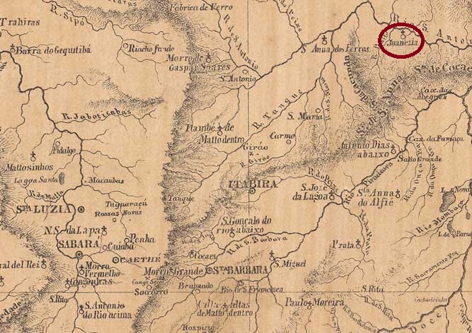
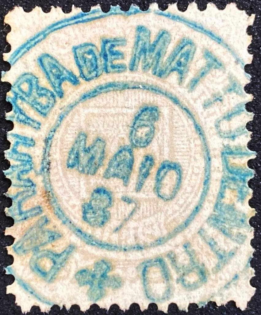
This locality was originally a parish of the Freguesia de Sant’Anna dos Ferros and was located near the eastern bank of the Santo Antonio, 290 kilometres north of the provincial capital Ouro Preto. In May 1852, it was elevated to the status of Freguesia of the Vila de Itabira. This was followed by two name changes: in August 1864, it became the Freguesia de Parahyba de Matto Dentro and, in October 1881, Joanezia. In September 1884, Joanésia (in its current spelling) became a parish of the Vila de Sant’Anna dos Ferros and, from September 1923, a district of the Municípios de Mesquita. Joanésia has been an independent municipality since December 1953.
Both Paula Sobrinho in História Postal de Minas Gerais (Belo Horizonte, 1997) and R. Koester (Carimbologia XXIX) agree that there has been a post office there since June 1879. The only imperial postmark to date is PMG-1810a (image from the Marcio Duarte collection), which also exists in turquoise:
PMG-1810a (MDu) 1887-1894 (at that time, the place was already called Joanezia).Villiers de l’Ile Adam: Carta (…) da Provincia de Minas Geraes, 1849
Outros nomes: Joanezia (1881)
Esta localidade era originalmente um curato da Freguesia de Sant’Anna dos Ferros e ficava próxima à margem leste do rio Santo Antonio, 290 quilômetros ao norte da capital provincial, Ouro Preto. Em maio de 1852, foi elevada à categoria de Freguesia da Vila de Itabira. Seguiram-se duas mudanças de nome: em agosto de 1864, tornou-se Freguesia de Parahyba de Matto Dentro (Paraíba era uma fazenda da região) e, em outubro de 1881, finalmente Joanezia. Em setembro de 1884, Joanésia (na grafia atual) tornou-se uma freguesia da Vila de Sant’Anna dos Ferros e, a partir de setembro de 1923, um distrito do município de Mesquita. Desde dezembro de 1953, Joanésia é um município independente.
Tanto Paula Sobrinho, em História Postal de Minas Gerais (Belo Horizonte, 1997), quanto R. Koester (Carimbologia XXIX) concordam que havia uma agência dos correios no local desde junho de 1879. O único carimbo postal imperial conhecido até agora é o PMG-1810a (imagem: col. Marcio Duarte), que também existe em turquesa:
PMG-1810a (MDu) 1887-1894 (na época, o local já se chamava Joanezia)Provincia de Minas Geraes, 1873
Andere Namen: Joanezia (1881)
Diese Ortschaft war ursprünglich eine Pfarrei der Freguesia de Sant’Anna dos Ferros und lag nah am Ostufer des Santo Antonio, 290 Kilometer nördlich der Provinzhauptstadt Ouro Preto. Im Mai 1852 wurde sie zur Freguesia der Vila de Itabira erhoben. Es folgten zwei Umbenennungen: Im August 1864 wurde sie zur Freguesia de Parahyba de Matto Dentro und im Oktober 1881 schließlich zu Joanezia. Im September 1884 wurde Joanésia (in der heutigen Schreibweise) eine Freguesia der Vila de Sant’Anna dos Ferros und war ab September 1923 ein Distrito des Municípios de Mesquita. Seit Dezember 1953 ist Joanésia ein eigenständiger Município.
Sowohl Paula Sobrinho in História Postal de Minas Gerais (Belo Horizonte, 1997) als auch R. Koester (Carimbologia XXIX) sind sich einig, dass es dort seit Juni 1879 ein Postamt gab. Der bisher einzige kaiserliche Poststempel ist PMG-1810a (Abb.: Samml. Marcio Duarte), den es auch in Türkis gibt:
PMG-1810a (MDu) 1887-1894 (damals hieß der Ort bereits Joanezia)
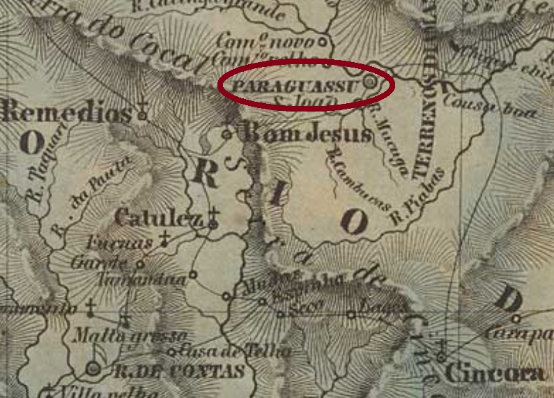
Villiers de l’Ile Adam: Carta (…) da Provincia da Bahia, 1848
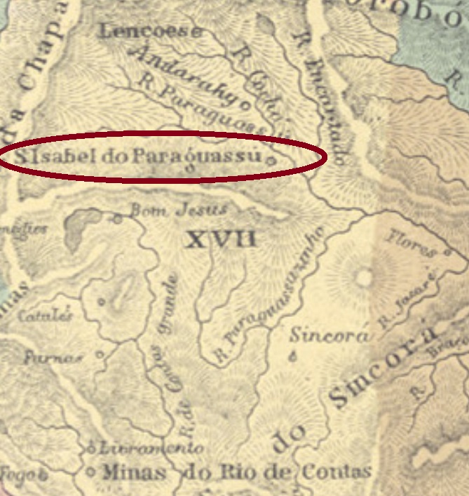
Other names: Chapada de Paraguassu, Paraguassu Diamantino, Paraguassu, S. João do Paraguassu, Mucugê (1917)
See also: Santa Izabel do Paraguassu (SBA-0655)
The Villa of Santa Izabel do Paraguassu (sometimes simply written Santa Izabel) was created in May 1847, originating from the old district of Mucugê do Paraguassu, in the municipality of Rio de Contas on the east bank of the Paraguaçu River, 450 km west of the provincial capital Salvador da Bahia. The village has progressed very fast through the discovery of gold and diamonds and had over 23 thousand inhabitants by 1880 (in 2022: ca. 12 thousand). In October 1890 it became the town of São João do Paraguassu, and since August 1917 both town and municipality are called Mucugê.
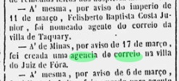
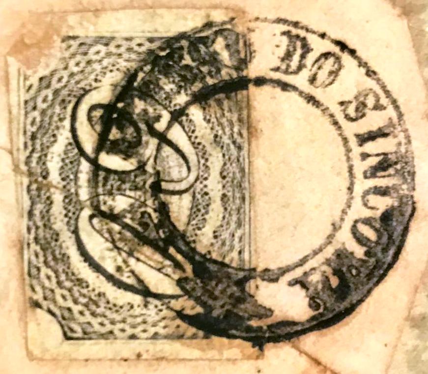
Three different periods were found for the creation of the local post office. The first among them took place in 1845, according to the Report of the Imperial Ministery of that year:
Relatorio do Ministerio do Imperio, 1845
Nova Monteiro (Administrações e Agencias Postaes do Brasil Imperio, in Brasil Filatelico/RJ, 1934-5; Reprint SPP 1994-1999) writes the exact date of July 9, 1855. Finally, R. Koester (Carimbologia XXIX) lists this agency as created on May 4th, 1868; this year is confirmed by the Imperial Mail Register (Tabella das Agencias do Correio do Imperio) of 1885. Possibly all dates are correct, and the office was closed at least twice in the meantime.
The only postmark from the imperial era to date is PBA-0655a (Klerman W. Lopes Collection):
PBA-0655a (KL) 1844ff
For postmarks with Santa Izabel do Paraguassu, see SBA-0655.
Atlas do Imperio do Brasil, 1868
Outros nomes: Chapada de Paraguassu, Paraguassu Diamantino, Paraguassu, S. João do Paraguassu, Mucugê (1917)
Veja também Santa Izabel do Paraguassu (SBA-0655)
A vila de Santa Izabel do Paraguassu (às vezes apenas escrito Santa Izabel) foi criada em maio de 1847, originária do antigo distrito de Mucugê do Paraguassu, na margem oriental do Rio Paraguaçu, município de Rio de Contas, 450 km a oeste da capital provincial Salvador da Bahia. Com a descoberta de ouro e diamantes, a vila cresceu rápido, chegando a mais de 23 mil habitantes até 1880 (em 2022: ca. 12 mil). Em outubro de 1890 tornou-se a cidade de São João do Paraguassu, e desde agosto de 1917 a cidade e o município chamam-se Mucugê.
Foram encontrados três períodos diferentes para a criação dos correios locais. O primeiro deles ocorreu em 1845, de acordo com o Relatório do Ministério do Império daquele ano:
Relatório do Ministério do Império, 1845
Nova Monteiro (Administrações e Agencias Postaes do Brasil Imperio, in Brasil Filatelico/RJ, 1934-5; Reprint SPP 1994-1999) escreve a data exata de 9 de julho de 1855. E já R. Koester (Carimbologia XXIX) lista esta agência com data de 4 de maio de 1868. Este ultimo ano é confirmado pela Tabella das Agencias do Correio do Imperio de 1885. É possível que todas as datas estejam corretas, e que a agência tenha fechado pelo menos duas vezes entre elas.
O único carimbo postal da época imperial até agora é o PBA-0655a (Coleção Klerman W. Lopes):
PBA-0655a (KL) 1844ff
Para carimbos postais com Santa Izabel do Paraguassu veja SBA-0655.
Carta da Republica dos Estados Unidos do Brazil, 1892
Andere Namen: Chapada de Paraguassu, Paraguassu Diamantino, Paraguassu, S. João do Paraguassu, Mucugê (1917)
Siehe auch: Santa Izabel do Paraguassu (SBA-0655)
Die Villa von Santa Izabel do Paraguassu (manchmal einfach Santa Izabel geschrieben) wurde im Mai 1847 aus dem ehemaligen Distrikt von Mucugê do Paraguassu im Município von Rio de Contas und lag am Ostufer des Flusses Paraguaçu, 450 km westlich der Provinzhauptstadt Salvador da Bahia entfernt. Die Ortschaft wuchs rasch nach der Entdeckung von Gold- und Diamentenvorkommen und zählte 1880 über 23.000 Einwohner (2022: knapp über 12.000). Im Oktober 1890 wurde daraus die Stadt João do Paraguassu, seit August 1917 heißen Stadt und Municipio Mucugê.
Es wurden drei verschiedene Zeiträume für die Gründung der örtlichen Poststelle ermittelt. Der erste davon fand laut dem Bericht des Kaiserlichen Ministeriums im Jahr 1845 statt:
Relatorio do Ministerio do Imperio, 1845
Nova Monteiro (Administrações e Agencias Postaes do Brasil Imperio, in Brasil Filatelico/RJ, 1934-5; Reprint SPP 1994-1999) schreibt das exakte Datum 9. Juli 1855. Schließlich listet R. Koester (Carimbologia XXIX) diese Agentur mit Entstehungsdatum 4. Mai 1868 auf, ein Jahr, das durch das Verzeichnis der kaiserlichen Postämter (Tabella das Agencias do Correio do Imperio) von 1885 bestätigt wird. Möglicherweise sind alle Angaben richtig, und das Amt wurde zweimal in der Zwischenzeit geschlossen.
Der bisher einzige Poststempel der Kaiserzeit ist PBA-0655a (Samml. Klerman W. Lopes):
PBA-0655a (KL) 1844ff
Für Poststempel mit Santa Izabel do Paraguassu siehe SBA-0655.
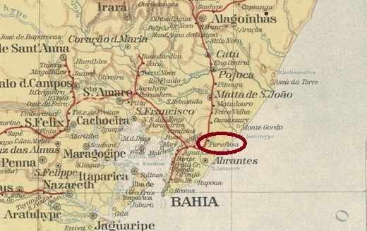
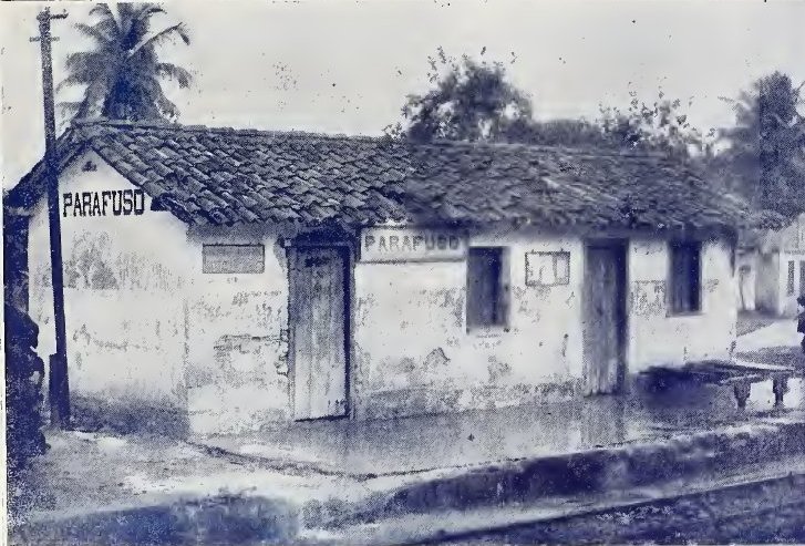
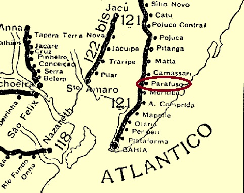
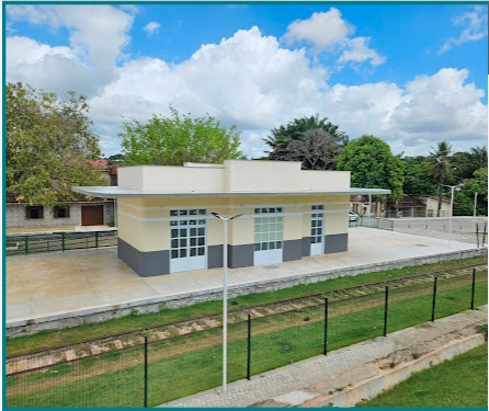
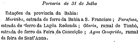
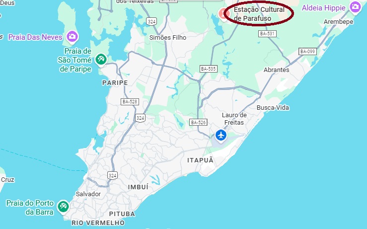
Parafuso (Screw) station was opened in September 1861 by the E.F. Bahia ao S. Francisco Railway Company as part of the main line. It was located 40 kilometres northeast of the provincial capital Salvador da Bahia. In 1911, it was transferred to the Cie. Chemins de Fer Fédéraux de l’Est Brésilien, then to V.F.F. Leste Brasileiro in 1935, and belonged to Rede Ferroviária Federal S.A. from 1975 until its closure in 1996 (estacoesferroviarias.com.br). The tracks are still in place and the station building is used as a cultural centre for the community.
In 1942 (illustration V.F.F. Leste Brasileiro, on estacoesferroviarias.com.br)In September 2025 (photo: Nilmara Moreira, on Google Maps)
The area around the station belonged to the Municipality of Abrantes from August 1920, to the Municipality of Montenegro from July 1925, and has been part of the Municipality of Camaçari since March 1938.
According to the Postbulletin (Boletim Postal), there had been a post office there since July 1889:
Boletim Postal, 1889
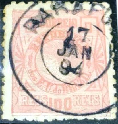
The oldest postmark to date is PBA-0935a (image from the internet):
PBA-0935a (WA) 1894Rede Ferroviária da Bahia,1898 (IBGE)
A estação Parafuso foi inaugurada em setembro de 1861 pela E.F. Bahia ao S. Francisco (Linha Tronco). Ela ficava a 40 quilômetros a nordeste da capital do estado, Salvador da Bahia. Em 1911, ela passou para a Cie. Chemins de Fer Fédéraux de l’Est Brésilien, depois para a V.F.F. Leste Brasileiro em 1935 e pertenceu à Rede Ferroviária Federal S.A. de 1975 até seu fechamento em 1996 (estacoesferroviarias.com.br). Os trilhos ainda estão lá e o prédio da estação é usado como centro cultural da comunidade.
Em 1942 (Ilustração V.F.F. Leste Brasileiro, em estacoesferroviarias.com.br)Em setembro de 2025 (Foto: Nilmara Moreira, no Google Maps)
A área ao redor da estação pertenceu ao Município de Abrantes a partir de agosto de 1920, ao Município de Montenegro a partir de julho de 1925 e, desde março de 1938, ao Município de Camaçari.
Conforme consta no Boletim Postal, havia uma agência dos correios no local desde julho de 1889:
Boletim Postal, 1889
O carimbo postal mais antigo encontrado até o momento é o PBA-0935a (fig. da internet):
PBA-0935a (WA) 1894PBA-0935a (WA) 1894
Der Bahnhof Parafuso (Schraube) wurde im September 1861 von der Eisenbahngesellschaft E.F. Bahia ao S. Francisco als Teil der Hauptlinie eröffnet. Er lag 40 Kilometer nordöstlich der Provinzhauptstadt Salvador da Bahia. Er ging 1911 an die Cie. Chemins de Fer Fédéraux de l’Est Brésilien über, dann 1935 an die V.F.F. Leste Brasileiro und gehörte von 1975 bis zu seiner Stilllegung im Jahr 1996 zur Rede Ferroviária Federal S.A. (estacoesferroviarias.com.br). Die Schienen sind noch vorhanden und das Bahnhofsgebäude wird als Kulturzentrum der Gemeinde genutzt.
Im Jahr 1942 (Abbildung V.F.F. Leste Brasileiro, auf estacoesferroviarias.com.br)Im September 2025 (Foto: Nilmara Moreira, auf Google Maps)
Das Areal um den Bahnhof gehörte ab August 1920 zum Município de Abrantes, ab Juli 1925 zum Município de Montenegro und liegt seit März 1938 im Município de Camaçari.
Wie aus dem Postbulletin (Boletim Postal) hervorgeht, gab es dort ein Postamt seit Juli 1889:
Boletim Postal, 1889
Der bisher älteste Poststempel ist PBA-0935a (Abb. aus dem Internet):