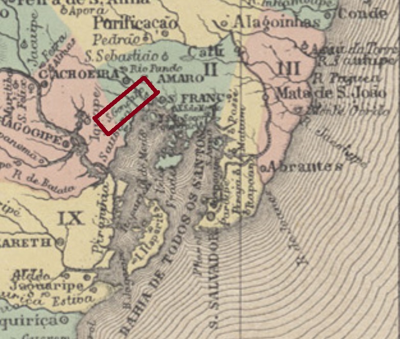
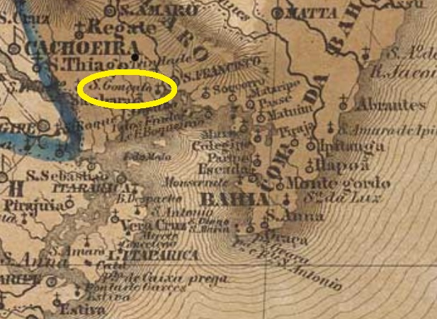
This very old village – in Brazilian terms – was already a freguesia under Cachoeira in the late 17th century and was located about 110 km northwest of the then colonial capital Salvador da Bahia. In July 1884 it rose to a villa and in June 1897 to a town. The name was simplified in 1931 to São Gonçalo, but the old toponym returned in 1943.
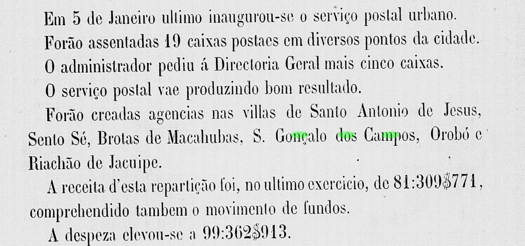
The local post office was established in 1880, as can be seen from the provincial government’s annual report for 1881:
Relatorio do Conselho Interino do Governo da Bahia, 1881
Until now, no postmark of the imperial era could be surely assigned to this locality.
Villiers de l’Ile Adam: Carta (…) da Província da Bahia, 1848
Anderer Name: São Gonçalo (1931-1943)
Diese sehr alte Ortschaft – für brasilianische Verhältnisse – war schon im späten 17. Jahrhundert eine Freguesia bei Cachoeira, und lag gut 110 km nordwestlich der damaligen kolonialen Hauptstadt Salvador da Bahia entfernt. Im Juli 1884 stieg sie zu einer Villa und im Juni 1897 zur Stadt. Der Ortsname wurde 1931 zu São Gonçalo vereinfacht, aber diese Bezeichnung wurde 1943 wieder aufgehoben.
Das örtliche Postamt wurde 1880 ins Leben gerufen, wie aus dem Jahresbericht der Provinzregierung für 1881 hervorgeht:
Relatorio do Conselho Interino do Governo da Bahia, 1881
Bisher konnte kein Poststempel der Kaiserzeit mit Sicherheit dieser Gemeinde zugeordnet werden.
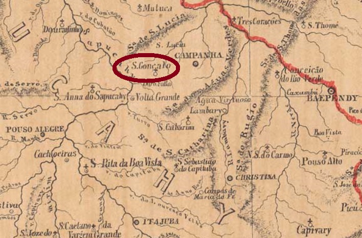
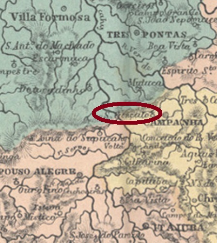
From July 1819, this São Gonçalo in the province of Minas Gerais was a freguesia of Campanha, located not far from the eastern bank of the Sapucahy River, about 400 km southwest of the capital Ouro Preto. It was also called the São Gonçalo da Campanha do Rio Verde, which is misleading, since the Verde Rio is relatively close to Campanha, but quite far away from São Gonçalo. Perhaps for this reason, in October 1878, the village was renamed as S. Gonçalo do Sapucahy, and the very year after that, political emancipation came as an own municipality.
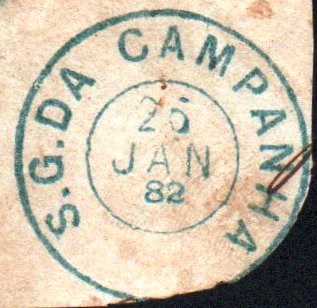
Both Nova Monteiro (Administrações e Agencias Postaes do Brasil Imperio, in Brasil Filatelico/RJ, 1934-5; Reprint SPP 1994-1999) and Paula Sobrinho (Historia Postal de Minas Gerais, Belo Horizonte, 1997) agree that the local post office was created in June 1865. So here we will find imperial postmarks bearing both old and toponyms. The first cancel is the beautiful SMG-3445a (Coll. Fuad Ferreira Fo.), whose two halves are almost completely depicted here, together with a mute cancel:
SMG-3445a (Coll. Fuad Ferreira Fo.)
It is followed by SMG-3445b (Coll. José A. Junges), with a later date than the toponymic change:
SMG-3445b (Coll. José A. Junges)
The next cancel is SMG-2330a (Coll. José A. Junges): a double circle with the inscriptions S. GONÇALO DE SAPUCAHY above and (MINAS) below; the word DE has here smaller letters. The dates at the centre are from about 1882 to 1893. SMG-2330b (Coll. José Renato C. de Souza) is almost identical to its predecessor, but here the letters of DE have the same size as the others. The only copy found has a date from 1885 at the centre.
Atlas do Imperio do Brasil, 1868
Printausgabe-Textaktualisierung vom 7. März 2021
Anderer Name: São Gonçalo da Campanha do Rio Verde
Dieser São Gonçalo in der Provinz Minas Gerais war ab Juli 1819 eine Freguesia von Campanha und lag nicht weit weg vom Ostufer des Sapucahy-Flusses, rund 400 km südwestlich der Hauptstadt Ouro Preto. Er hieß auch São Gonçalo da Campanha do Rio Verde, was irreführend ist, da der Rio Verde zwar relativ nah an Campanha liegt, aber ziemlich weit weg von São Gonçalo. Vielleicht deswegen wurde der Ort im Oktober 1878 zu São Gonçalo do Sapucahy umbenannt, und gleich im Jahr später kam die politische Eigenständigkeit als Município dazu.
Sowohl Nova Monteiro (Administrações e Agencias Postaes do Brasil Imperio, in Brasil Filatelico/RJ, 1934-5; Reprint SPP 1994-1999) als auch Paula Sobrinho (História Postal de Minas Gerais, Belo Horizonte, 1997) sind sich darüber einig, dass das örtliche Postamt vom Juni 1865 ist. Hier werden wir also imperiale Poststempel finden, die sowohl den alten als auch den neuen Ortsnamen tragen. Der erste Stempel ist der wunderschöne SMG-3445a (Samml. Fuad Ferreira Fo.), dessen zwei Hälften hier fast vollständig abgebildet sind, dazu eine stumme Entwertung:
SMG-3445a (Samml. Fuad Ferreira Fo.)
Ihm folgt SMG-3445b (Samml. José A. Junges), mit einem Datum aus der Zeit, als der Ort bereits anders hieß:
SMG-3445b (Samml. José A. Junges)
Der nächste Stempel ist SMG-2330a (Samml. José A. Junges): ein Doppelkreis mit den Inschriften S. GONÇALO DE SAPUCAHY oben und (MINAS) unten, wobei das Wort DE kleinere Buchstaben als die anderen hat. Die Daten in der Mitte gehen von ca. 1882 bis 1893. SMG-2330b (Samml. José Renato C. de Souza) ist fast identisch mit dem Vorgänger, aber hier sind die Buchstaben von DE gleich groß wie die anderen. Das einzig gefundene Exemplar hat ein Datum aus 1885 in der Mitte.
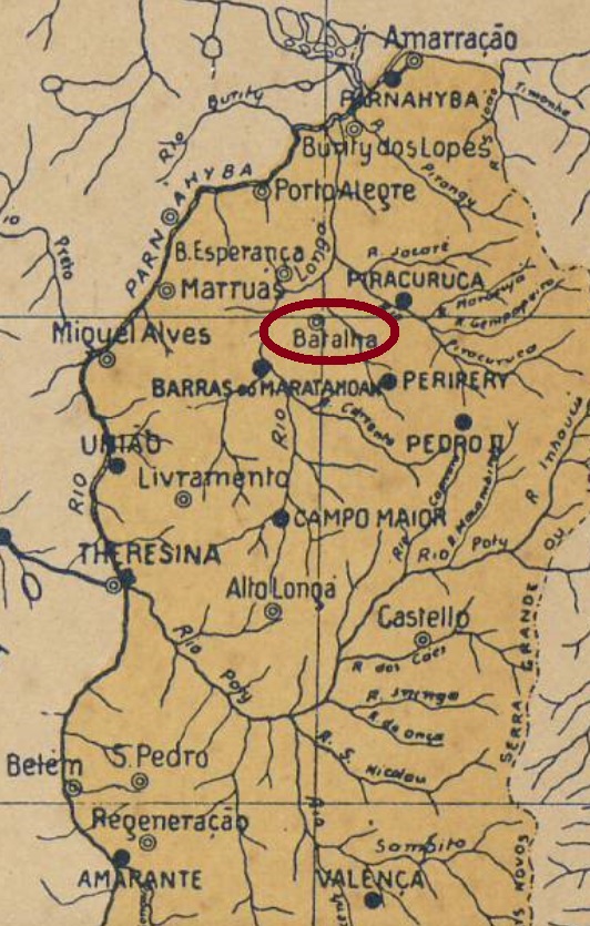
This second village in the province of Piauí in honour of Gonçalo (Gundisalvus) of Amarante – who was actually no Saint – became a district of Piracuruca in August 1853 and was located about 160 km northeast of the then newly created capital Teresina. Most historians assert that the name Batalha (= Battle) came from the long wars between Indians and Portuguese occupiers, but a reference to the Portuguese town of Batalha would also be plausible.
The locality became the villa of Batalha in December 1855. In June 1899, the municipality was renamed Campos Salles, in honour of the then Brazilian President Manuel Ferraz de Campos Salles (1841-1913). The connection to the unpopular president from São Paulo did not last long, and the name Batalha returned for good in June 1911.
Three creation dates for the local post office were found, apparently a sure hint that it was closed in between. Reinhold Koester (Carimbologia III) states that 22 March 1856, a year confirmed by the annual report of the General Postal Directory (Directoria Geral dos Correios) for 1859. Nova Monteiro, on the other hand, writes in Administrações e Agencias Postaes do Brasil Imperio (Brasil Filatelico/RJ, 1934-5; Reprint SPP 1994-1999) the exact date March 22, 1865. But this could be a misprint, as this date is very similar to the previous one. Finally, 1882 is mentioned as the third creation year by R. Koester.
A single imperial postmark was found under this place name: SPI-0200a (Samml. Jorge L. Pedreira) consists of a double circle with the inscription S.G. DA BATALHA above. The only known copy has a date from 1881 at the centre. And if the agency was in operation in 1881, an opening date from 1882 is unlikely.
Arthur D. Ribeiro: Estado do Piauhy, 1924
Buchtext-Aktualisierung vom 7. März 2021
Andere Namen: Campos Salles, Batalha
Siehe auch Batalha (R. Koester: Carimbologia III)
Diese zweite Ortschaft der Provinz Piauí zu Ehren von Gonçalo (Gundisalvus) von Amarante – der eigentlich kein Heiliger war – wurde im August 1853 ein Distrikt von Piracuruca und lag ca. 160 km nordöstlich der damals frisch gekürten Hauptstadt Teresina. Die meisten Historiker meinen, der Name Batalha (= Schlacht) käme von den langen Kriegen zwischen Indianern und portugiesischen Besatzern, aber eine Anlehnung an die portugiesische Stadt Batalha wäre auch denkbar.
Aus dem Ort wurde im Dezember 1855 die Villa von Batalha. Im Juni 1899 wurde der Município zu Campos Salles umbenannt, zu Ehren vom damaligen brasilianischen Präsidenten Manuel Ferraz de Campos Salles (1841-1913). Der neue Ortsname fand offenbar kein Gefallen. Die Verbindung zum unbeliebten Präsidenten aus São Paulo währte nicht lange, und der Name Batalha kehrte im Juni 1911 definitiv zurück.
Es wurden drei Gründungsdaten fürs örtliche Postamt gefunden, im Prinzip ein sicheres Indiz dafür, dass es zwischendurch geschlossen wurde. Reinhold Koester (Carimbologia III) gibt hierfür den 22. März 1856 an, ein Jahr, dass durch den Jahresbericht der Allgemeinen Postdirektion (Directoria Geral dos Correios) für 1859 bestätigt wird. Nova Monteiro dagegen schreibt in Administrações e Agencias Postaes do Brasil Imperio(Brasil Filatelico/RJ, 1934-5; Reprint SPP 1994-1999) das genaue Gründungsdatum 22. März 1865. Da könnte aber ein Zahlendreher ins Spiel sein, da dieses Datum sehr ähnlich wie das frühere ist. Schließlich wird aus 1882 als Gründungsjahr durch R. Koester erwähnt.
Ein einziger Poststempel der Kaiserzeit wurde unter diesem Ortsnamen gefunden: SPI-0200a (Samml. Jorge L. Pedreira) besteht aus einem Doppelkreis mit der Inschrift S.G. DA BATALHA oben. Das einzig bekannte Exemplar hat ein Datum aus 1881 in der Mitte. Und wenn die Agentur 1881 in Betrieb war, ist ein Eröffnungsdatum aus 1882 unwahrscheinlich.
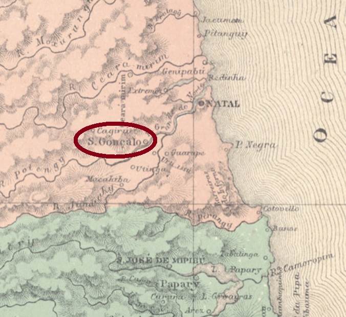
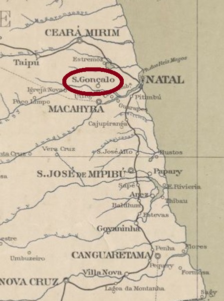
Located in the province of Rio Grande do Norte, about 20 km west of the capital Natal, this São Gonçalo has a very eventful history. It rose to a municipality four times: in April 1833, then in 1874, 1890 and most recently in December 1958. And in between it descended three times to a district, either of Natal or, most recently, of Macaíba. Now stability has been restored, and the municipality is nowadays called São Gonçalo do Amarante.
The postal history of this village also seems to have been uneasy. The Imperial Mail Register (Tabella das Agencias do Correio do Imperio) of 1885 lists the local post office from 1818 on. But this is probably a misprint, because Nova Monteiro writes in Administrações e Agencias Postaes do Brasil Imperio (Brasil Filatelico/RJ, 1934-5; Reprint SPP 1994-1999) another date, which is exactly 30 years later. A press note from Rio in December 1848 indirectly confirms this last statement:
Correio Mercantil/RJ, 23.12.1848, Ministerial Protocol of 16.12.
At the end of the Empire, on September 19, 1889, however, the agency was closed, as announced in the Postal Report for October of that year:
Boletim Postal 6/89 (October 1889)
Until now, no postmark of the imperial era could be doubtless assigned to this municipality.
Serviço Geologico e Mineralogico, 1910
Anderer Name: São Gonçalo do Amarante (1958)
Dieser São Gonçalo in der Provinz Rio Grande do Norte liegt etwa 20 km westlich der Hauptstadt Natal und hat ebenfalls eine sehr bewegte Geschichte hinter sich. Er stieg viermal zum Município auf: im April 1833, danach 1874, 1890 und zuletzt im Dezember 1958. Und stieg zwischendurch dreimal zum Distrikt ab, von Natal oder zuletzt von Macaíba. Jetzt ist Stabilität eingekehrt, und die Gemeinde heißt nun São Gonçalo do Amarante.
Auch die Postgeschichte dieser Ortschaft scheint unruhig gewesen zu sein. Im Verzeichnis der kaiserlichen Postämter (Tabella das Agencias do Correio do Imperio) von 1885 liest man, das örtliche Postamt entstand 1818. Das dürfte aber ein Druckfehler sein, denn Nova Monteiro schreibt in Administrações e Agencias Postaes do Brasil Imperio, (Brasil Filatelico/RJ, 1934-5; Reprint SPP 1994-1999) ein Datum dafür, das exakt 30 Jahre später liegt. Eine Pressenotiz aus Rio im Dezember 1848 bestätigt indirekt diese letzte Angabe:
Correio Mercantil/RJ, 23.12.1848, Ministerialprotokoll vom 16.12.
Am Ende des Kaiserreichs, am 19.9.1889, wurde die Agentur jedoch geschlossen, wie im Postbericht für Oktober d.J. angekündigt:
Boletim Postal 6/89 (Oktober 1889)
Bisher konnte kein Poststempel der Kaiserzeit zweifelsfrei dieser Gemeinde zugeordnet werden.
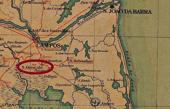
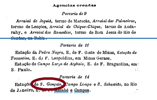
Other names: São Gonçalo de Campos, Goytacazes (1915)
This was another railway station in the province of Rio de Janeiro. It was located in the municipality of Campos dos Goytacazes, about 280 km northeast of the imperial capital Rio de Janeiro. The station was inaugurated in 1873 by the E.F. Campos a São Sebastião Railway Company, in 1889 it was transferred to the E.F. Macahé e Campos, and shortly thereafter to the E. F. Leopoldina. In 1915, the station was renamed Goytacazes. From 1975 until the end of 1996, the railway line belonged to the Rede Ferroviária Federal S.A.; today the building hosts a restaurant, the rails are still there (estacoesferroviarias.com.br).
The station post office was established on 14.11. 1889, exactly one day before the strike that proclaimed the republic. It is therefore highly unlikely that there would be a postmark from the Empire. The post office was announced in the Postal Report for December 1889:
Boletim Postal 8/89, December 1889In 1996. Photo: Ralph M. Gisbrecht (estacoesferroviarias.com.br)
Andere Namen: São Gonçalo de Campos, Goytacazes (1915)
Dieser ist ein anderer São Gonçalo-Bahnhof in der Provinz Rio de Janeiro. Er lag im Município von Campos dos Goytacazes, ca. 280 km nordöstlich der kaiserlichen Hauptstadt Rio de Janeiro entfernt. Der Bahnhof wurde 1873 durch die E.F. Campos a São Sebastião-Bahngesellschaft eingeweiht, 1889 ging er zur E.F. Macahé e Campos über, um kurz darauf zur E. F. Leopoldina zu wechseln. 1915 wurde der Bahnhof zu Goytacazes umbenannt. Von 1975 bis Betriebsende 1996 gehörte die Bahnlinie der Rede Ferroviária Federal S.A., heute soll das Gebäude als Gaststätte dienen, aber die Schienen sind noch da (estacoesferroviarias.com.br).
Das Bahnhofspostamt wurde am 14.11. 1889 ins Leben gerufen, also genau einen Tag vor dem Putsch, der die Republik ausgerufen hat. Es ist daher äußerst unwahrscheinlich, dass es einen Poststempel aus dem Kaiserreich gibt. Das Postamt wurde im Postbericht für Dezember 1889 angekündigt:
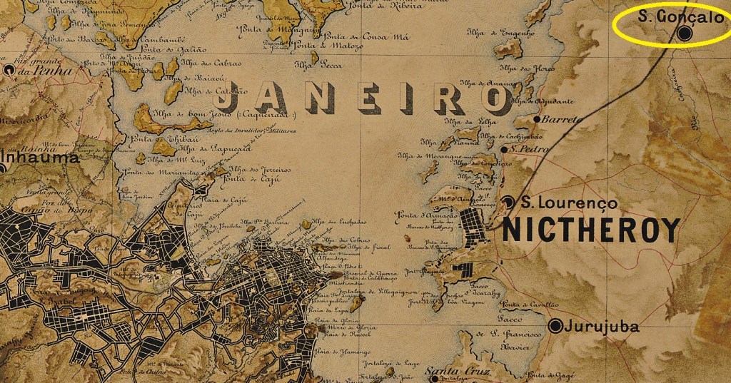
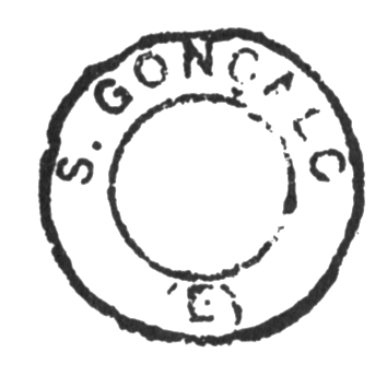
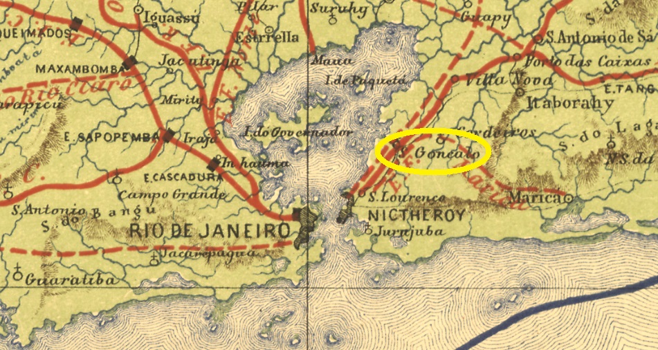
The locality of São Gonçalo in the province of Rio de Janeiro is a very ancient settlement in Brazilian terms: as early as February 1647, it was a freguesia of Niterói, which was located about 30 km northeast of the later capital Rio de Janeiro. However, it was not until September 1890 that it was elevated to a villa in own municipality; since 1922 it has the city status.
Although here according to Nova Monteiro (Administrações e Agencias Postaes do Brasil Imperio, in Brasil Filatelico/RJ, 1934-5; Reprint SPP 1994-1999) a post office has existed since September 1852, so far no postmark of the imperial period could be assigned to this municipality without any doubt. Paulo Novaes (agenciaspostais.com.br) assumes that the agency on site was closed after the opening of the station post office, which seems very plausible.
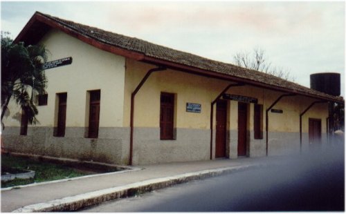
In 1874, a local train station was founded by the Cia. Ferro-Carril Nictheroyense, but soon after passed into the possession of the E.F. Leopoldina Railway Company in the so-called coastline (Linha do Litoral). From 1975 to operation end in 1996, the line belonged to the Rede Ferroviária Federal S. A. Today, the station serves as a material warehouse for the municipality, the rails having already been removed (estacoesferroviarias.com.br). The station post office was inaugurated in April 1874, as reported by the Rio press:
Jornal do Commercio, April, 12 1874
From this station a postmark of the imperial period was found. Cícero A. Almeida showed SRJ-0936b in Carimbos Postais – século XIX (Rio de Janeiro, 1989) under No. 220 (MPT 823):
SRJ-0936b (MPT 823)Estrada de Ferro Central do Brasil, 1890
Printausgabe-Aktualisierung vom 4. März 2021
Dieses São Gonçalo in der Provinz von Rio de Janeiro ist eine für brasilianische Verhältnisse sehr alte Siedlung: bereits im Februar 1647 war es eine Freguesia von Niterói, die ca. 30 km nordöstlich der späteren Hauptstadt Rio de Janeiro entfernt lag. Allerdings erst im September 1890 wurde es zur Villa im eigenen Município erhoben, und seit 1922 besteht hier der Stadt-Status.
Obwohl es hier laut Nova Monteiro (Administrações e Agencias Postaes do Brasil Imperio, in Brasil Filatelico/RJ, 1934-5; Reprint SPP 1994-1999) ein Postamt seit September 1852 besteht, konnte bisher kein Poststempel der Kaiserzeit zweifelsfrei dieser Gemeinde zugeordnet werden. Paulo Novaes (agenciaspostais.com.br) nimmt an, dass nach der Eröffnung des Bahnhofspostamtes die Agentur vor Ort geschlossen wurde, was anhand der fehlenden Stempel sehr plausibel erscheint.
Der Bahnhof São Gonçalo wurde 1874 von der Gesellschaft Cia. Ferro-Carril Nictheroyense eingeweiht, ging aber bald danach in Besitz der E.F. Leopoldina-Bahngesellschaft in der sogenannte Küstenlinie (Linha do Litoral) über. Von 1975 bis Betriebsende 1996 gehörte die Linie der Rede Ferroviária Federal S. A. Heute dient der Bahnhof als Materiallager der Gemeinde, die Schienen wurden bereits entfernt (estacoesferroviarias.com.br). Das Bahnhofspostamt wurde im April 1874 ins Leben gerufen, wie die Presse aus Rio berichtet:
Jornal do Commercio, 12. April 1874
Von diesem Bahnhof wurde ein Poststempel der Kaiserzeit gefunden. Cícero A. Almeida zeigte SRJ-0936b in Carimbos Postais – século XIX (Rio de Janeiro, 1989) unter Nr. 220 (MPT 823):
Other names: São Gonçalo de Amarante, São Gonçalo da Regeneração, Regeneração (1875)
See also Regeneração (RPI-0140)
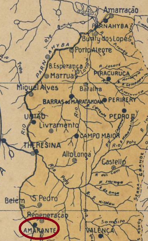
In colonial Brazil, from September 1801, São Gonçalo was a freguesia subordinated to Jerumenha and Valença, about 130 km south of the future capital Teresina. In July 1832 it was elevated to villa. This villa has a long and confused history, which is directly connected to the current city of Amarante. Both villages were one, but were separated in 1861 when a large part of the local population, together with the administration, moved to an area closer to the River Parnaíba. The resettlement was called Amarante, and the former S. Gonçalo became in August 1871 the district of São Gonçalo da Regeneração under Amarante. In July 1875, political emancipation returned, and the new municipality was given the actual name Regeneração.
To make things even more complicate, in November 1963, a part of Regeneração became the present-day municipality of São Gonçalo do Piauí. Today, Regeneração, Amarante and São Gonçalo do Piauí are three municipalities that have the same patron saint, the Portuguese Gonçalo de Amarante, who is venerated as a saint in both Portugal and Brazil, although his canonization process is not yet over.
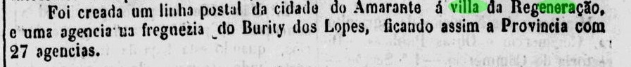
The local agency was founded in July 1830, as Nova Monteiro states in Administrações e Agencias Postaes do Brasil Imperio (Brasil Filatelico/RJ, 1934-5; Reprint SPP 1994-1999). With the village separation and the move to Amarante, the agency was probably closed, as it is not included in the Postal Guide of 1880 or in the Imperial Mail Register (Tabella das Agencias do Correio do Imperio) of 1885. It may have reopened in 1885 because a postal line was created this year between Amarante and Regeneração:
A Imprensa, 7 September 1885
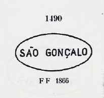
In the past, no postmark of the imperial era could be assigned to this municipality without any doubt. In the meantime, there is some evidence that the cancel SPI-0199a is the oldest postmark of this place. The image had already become known by Paulo Ayres (Catalogo de Carimbos Brasil-Império, S. Paulo, 1937, 1942) under No. 1490:
SPI-0199a (P. Ayres 1490), 1843ff-1866ffArthur D. Ribeiro: Estado do Piauhy, 1924
Textaktualisierung vom 18. März 2021
Andere Namen: São Gonçalo de Amarante, São Gonçalo da Regeneração, Regeneração (1875)
Siehe auch Regeneração (RPI-0140)
Im kolonialen Brasilien war São Gonçalo ab September 1801 eine Freguesia, die Jerumenha und Valença zugeordnet war und etwa 130 km südlich der künftigen Hauptstadt Teresina lag. Im Juli 1832 wurde es zur Villa erhoben. Diese Villa hat eine lange und konfuse Geschichte, die direkt mit der aktuellen Stadt Amarante verbunden ist. Beide Ortschaften waren eins, wurden aber 1861 getrennt, als ein Großteil der lokalen Bevölkerung, zusammen mit der Verwaltung, in ein Gebiet näher an den Fluss Parnaíba abzog. Die Umsiedlung wurde Amarante genannt, und die ehemalige S. Gonçalo wurde im August 1871 in Amarante der Distrikt von São Gonçalo da Regeneração. Im Juli 1875 kehrte wieder die politische Emanzipation, die neue Gemeinde erhielt den heutigen Namen Regeneração.
Um die Geschichte noch komplizierter zu machen, wurde im November 1963 ein Teil von Regeneração zur heutigen Gemeinde von São Gonçalo do Piauí. Regeneração, Amarante und São Gonçalo do Piauí sind heute drei Gemeinden, die den gleichen Schutzpatron haben, den Portugiesen Gonçalo de Amarante, der sowohl in Portugal als auch in Brasilien als Heiliger verehrt wird, obwohl sein Heiligsprechungsprozess noch nicht zu Ende ist.
Die lokale Agentur wurde im Juli 1830 gegründet, wie Nova Monteiro in Administrações e Agencias Postaes do Brasil Imperio (Brasil Filatelico/RJ, 1934-5; Nachdruck SPP 1994-1999). Mit der Trennung des Ortes und dem Umzug nach Amarante wurde die Agentur wahrscheinlich geschlossen, da sie weder im Postführer von 1880 noch im Verzeichnis der kaiserlichen Postämter (Tabella das Agencias do Correio do Imperio) von 1885 enthalten ist. Es könnte 1885 wiedereröffnet worden sein, weil in diesem Jahr eine Postlinie zwischen Amarante und Regeneração geschaffen wurde:
A Imprensa, 7. September 1885
Früher konnte kein Poststempel der Kaiserzeit zweifelsfrei dieser Gemeinde zugeordnet werden. Inzwischen spricht einiges dafür, dass der Stempel SPI-0199a die älteste postalische Entwertung dieses Orts ist. Die Abbildung war bereits durch Paulo Ayres (Catálogo de Carimbos Brasil-Império, S. Paulo, 1937, 1942) unter Nr. 1490 bekannt geworden:
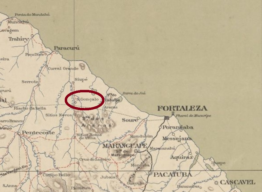
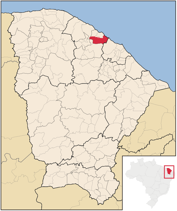
Other names: Paracuru, S. Gonçalo do Amarante (1953), Anacetaba (1943-53)
This village was originally a settlement in the district of Paracuru, municipality of Trahiry, situated about 60 km west of the provincial capital Fortaleza. It was not until October 1890 that it became a district, but as early as November 1921, the town had its own municipality. Since then, the place name changed twice: in December 1943 to Anacetaba, and in November 1953 to the current São Gonçalo do Amarante.
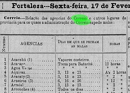
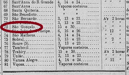
It is still not entirely clear whether there was a post office here during the imperial period of Brazil, because the evidence is rather thin. However, since this village appears in a list of Ceará post offices, which has been published in the provincial press, it remains here subject to confirmation:
Cearense, 17 February 1887
Until now, no postmark of the imperial period could be assigned to this municipality.
Raphael Lorenzeto de Abreu, CC_BY_2.5
Buchtext-Aktualisierung vom 2. März 2021
Andere Namen: Paracuru, S. Gonçalo do Amarante (1953), Anacetaba (1943-53)
Diese Ortschaft war ursprünglich eine Siedlung im Distrikt von Paracuru, Município von Trahiry, und lag gut 60 km westlich der Provinzhauptstadt Fortaleza. Erst im Oktober 1890 wurde daraus ein Distrikt, aber bereits im November 1921 hatte São Gonçalo einen eigenen Município. Seitdem wechselte der Ortsname zweimal: im Dezember 1943 zu Anacetaba, und im November 1953 zum aktuellen São Gonçalo do Amarante.
Es ist bis heute nicht vollkommen klar, ob es hier in der Kaiserzeit Brasiliens ein Postamt gab, denn die Beweislage ist eher dünn. Da aber diese Ortschaft in einer Liste der Ceará-Postämter auftaucht, die in der Provinzpresse veröffentlicht wurde, bleibt sie hier unter Vorbehalt:
Cearense, 17. Februar 1887
Bisher konnte kein Poststempel der Kaiserzeit dieser Gemeinde zugeordnet werden.
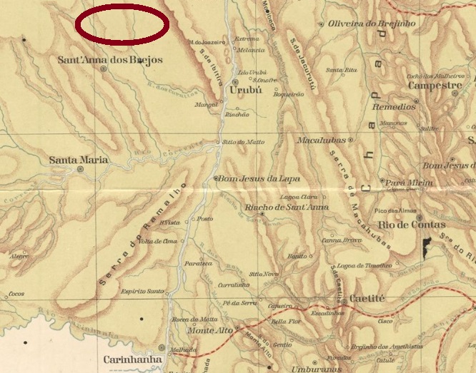
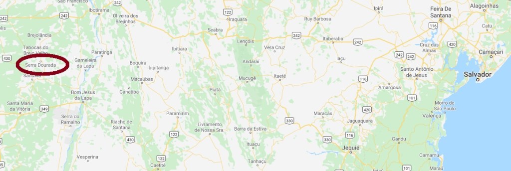
Other names: Sao Gonçalo dos Brejos, Penamar (1938), Serra Dourada (1962)
The history of this village began in 1868, with the settlement of São Gonçalo dos Brejos (= on the swamps) in the municipality of Santa Maria da Victoria, about 800 km west of the provincial capital Salvador da Bahia. Until 1881, it was an Arraial in the municipality of Carinhanha, before moving to the newly founded municipality of Sant’Anna dos Brejos in 1890. It was not until August 1906 that the district status was granted. Two toponym changes followed: in November 1938 to Penamar and in July 1962 to the current Serra Dourada (= Golden Mountains), when political emancipation came. As you can see, a literal rise in naming took place over time.
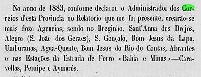
The local post office was created in 1883, as can be seen from the provincial president’s report for 1884:
Relatorio do Conselho Interino do Governo da Bahia, 1884
Until now, no postmark of the imperial era could be doubtless assigned to this locality.
Google Maps
Andere Namen: São Gonçalo dos Brejos, Penamar (1938), Serra Dourada (1962)
Die Geschichte dieser Ortschaft fing ab ca. 1868 an, mit der Siedlung von São Gonçalo dos Brejos (= der Sümpfe) im Município von Santa Maria da Victoria, ca. 800 km westlich der Provinzhauptstadt Salvador da Bahia entfernt. Bis 1881 war sie dann ein Arraial im Município von Carinhanha, bevor sie 1890 zur frisch gegründeten Gemeinde von Sant’Anna dos Brejos wechselte. Erst im August 1906 kam der Distrikt-Status. Es folgten zwei Änderungen des Ortsnamens: im November 1938 zu Penamar und im Juli 1962 zur aktuellen Serra Dourada (= Goldenes Gebirge), als die politische Emanzipation kam. Wie man sieht, ein buchstäblicher Aufstieg in der Namensgebung fand im Laufe der Zeit statt.
Das örtliche Postamt entstand 1883, wie man aus dem Bericht des Provinzpräsidenten für 1884 entnehmen kann:
Relatorio do Conselho Interino do Governo da Bahia, 1884
Bisher konnte kein Poststempel der Kaiserzeit zweifelsfrei dieser Gemeinde zugeordnet werden.
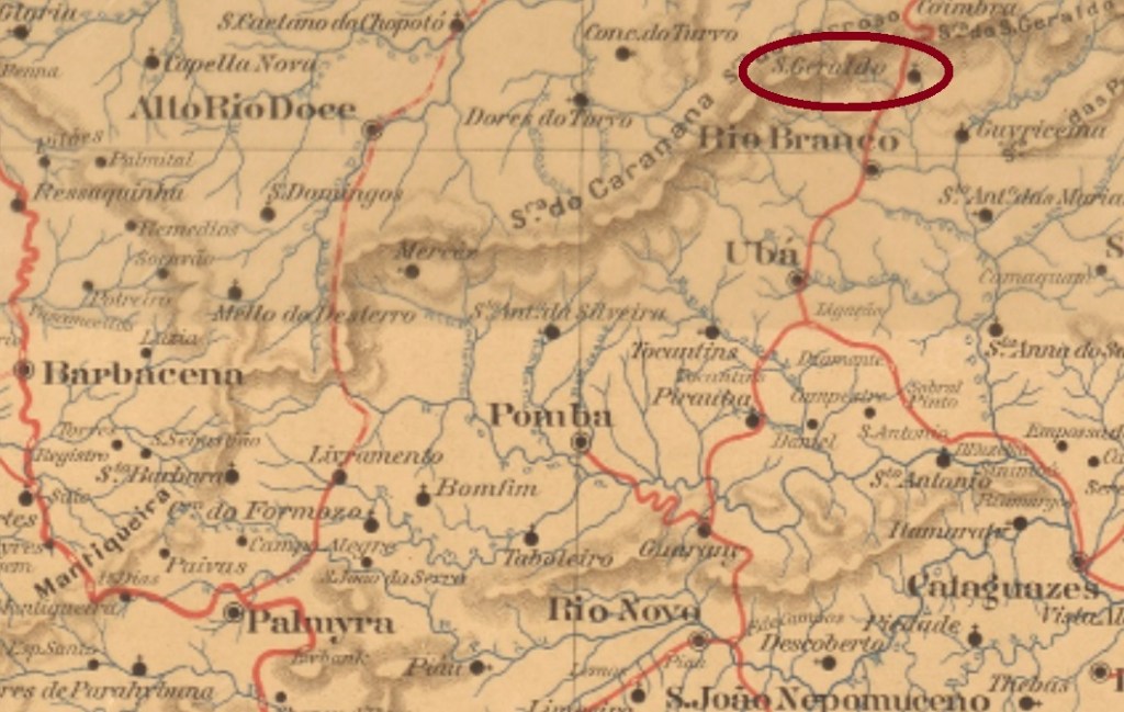
Carta da Republica dos Estados Unidos do Brazil, 1892
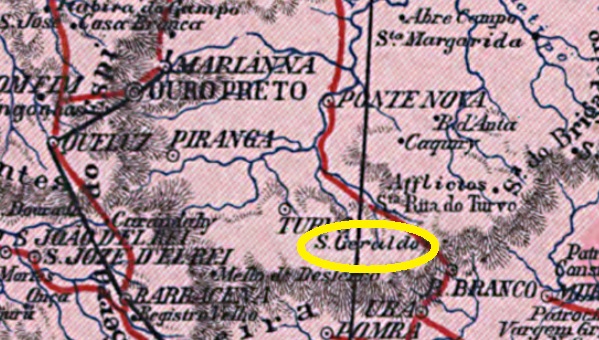
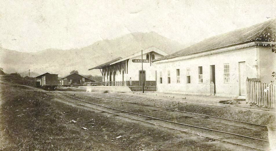
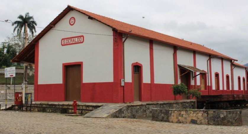
This station was inaugurated in March 1880 by the E.F. Leopoldina Railway Company on the Caratinga Line and was situated in the municipality of Presídio de Ubá (= Ubá’s prison, now Visconde de Rio Branco), about 150 km southeast of the provincial capital Ouro Preto. The line was transferred in 1975 to the state-run Rede Ferroviária Federal S.A. and remained in operation until 1996. Today the station has been restored.
The train station around 1940…… and in 2016 (Photo: Prefeitura Municipal, in estacoesferroviarias.com.br)
A settlement grew around the station. In 1882 it became a district, and since December 1948 it has been an independent municipality.
The local post office was built in July 1878, as reported by Paula Sobrinho (História Postal de Minas Gerais, Belo Horizonte, 1997). A postmark of the imperial period was found: SMG-2295a (Coll. Karlheinz Wittig) occurs also in purple and has a double circle with the inscription S. GERALDO (ESTAÇÃO). The dates at the centre are sometimes partly written by hand and vary from 1885 to 1898.
Mappa de Minas Geraes, 1910
Dieser Bahnhof wurde im März 1880 durch die E.F. Leopoldina Eisenbahngesellschaft in der Caratinga-Linie eingeweiht und lag im Município von Presídio de Ubá (= Ubás Gefängnis, heute Visconde de Rio Branco), ca. 150 km südöstlich der Provinzhauptstadt Ouro Preto entfernt. Die Linie ging 1975 an die staatliche Rede Ferroviária Federal S.A. über und blieb in Betrieb bis 1996. Heute ist der Bahnhof restauriert.
Der Bahnhof um 1940……und 2016 (Foto: Prefeitura Municipal, in estacoesferroviarias.com.br)
Um den Bahnhof herum wuchs eine Siedlung. 1882 wurde daraus ein Distrikt, seit Dezember 1948 ist São Geraldo ein eigenständiger Município.
Das örtliche Postamt entstand im Juli 1878, wie Paula Sobrinho berichtet (História Postal de Minas Gerais, Belo Horizonte, 1997). Ein Poststempel der Kaiserzeit war zu finden: SMG-2295a (Samml. Karlheinz Wittig) kommt auch in lila vor und hat einen Doppelkreis mit der Inschrift S. GERALDO (ESTAÇÃO). Die Daten in der Mitte sind mitunter teilweise per Hand geschrieben und gehen von 1885 bis 1898.