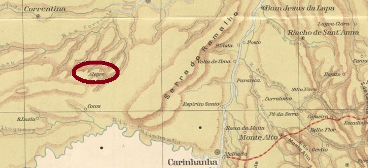
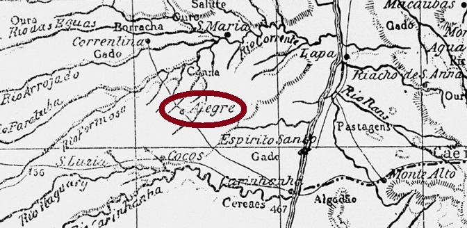
This locality was an Arraial (settlement) in the municipality of Carinhanha, situated more than 900 km west of the provincial capital Salvador da Bahia. In August 1923, it rose to a Villa called do Rio Alegre, but eight years later it was downgraded to the district of Santa Maria da Vitória. In 1938, the new name Coribe was added, and since August 1958 Coribe has been a municipality. The name is said to mean Merry River (Rio Alegre) in the Tupi-Guarani language.
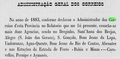
The local post office was established in 1883, as can be read in the provincial president’s report for the following year:
Relatório do Presidente da Provincia, 1884
So far, no postmark of the imperial era has appeared.
Laemmert: Estado da Bahia, 1913
Andere Namen: Alegre, Coribe (1938)
São João dos Geraes war ein Arraial (Weiler) im Município von Carinhanha, der über 900 km westlich der Provinzhauptstadt Salvador da Bahia entfernt lag. Im August 1923 stieg er zur Vila do Rio Alegre auf, aber acht Jahre später wurde der Ort als Distrikt von Santa Maria da Vitória rückgestuft. 1938 kam der neue Name Coribe dazu, und seit August 1958 ist Coribe ein Município. Der Name soll in der Tupi-Guarani-Sprache Fröhlicher Fluss (Rio Alegre) bedeuten.
Das örtliche Postamt entstand 1883, wie im Bericht des Provinzpräsidenten fürs folgende Jahr zu lesen ist:
Relatório do Presidente da Provincia, 1884
Bisher wurde kein Poststempel der Kaiserzeit gesichtet.
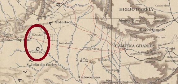
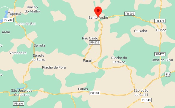
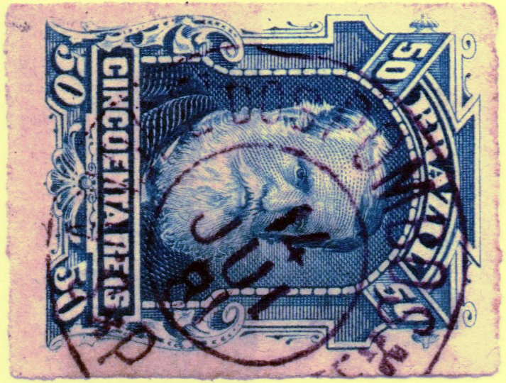
Santo André dos Pombos was originally part of the Fazenda dos Pombos (or Pombas, which means pigeons), which was so large that it also included the present-day neighbouring municipality of Pariri (formerly São José dos Pombos). It belonged to São João do Cariri and was located about 240 km west of the provincial capital Parahyba do Norte (today João Pessoa). Before 1911, it became a district, which until 1936 was given the simplified name Santo André. Between 1943 and 1949, this district was called Mucuitu – the word from the Native American language is said to mean itching. In January 1962, the district of Santo André became the newly founded municipality of Gurjão and gained its political autonomy as a municipality in April 1994.
The post office there was registered only in the List of the Postal Cancels in the Empire of Brazil (Wittig and Wittig, ArGe-Brazil, Lohmar, 2016). This is also confirmed by a single cancel from 1881:
SPB-0265a (Coll. José A. Junges), 1881
Since the post office was not listed either in the Imperial Postal Guide (Guia Postal do Imperio) of 1880 or in the Imperial Mail Register (Tabella das Agencias do Correio do Imperio) of 1885, we can assume that its short existence took place between the two years.
GoogleMaps
Andere Namen: Mucuitu, Santo André
Santo André dos Pombos war ursprünglich Teil der Fazenda dos Pombos (oder auch Pombas, was Tauben bedeutet), die so groß war, dass sie auch die heutige Nachbargemeinde von Pariri (früher São José dos Pombos) beinhaltete. Der Ort gehörte dem Município von São João do Cariri und lag ca. 240 km westlich der Provinzhauptstadt Parahyba do Norte (heute João Pessoa). Vor 1911 wurde daraus ein Distrikt, der bis 1936 den vereinfachten Namen Santo André trug. Zwischen 1943 und 1949 hieß dieser Distrikt Mucuitu – das Wort aus der Indianersprache soll Juckreiz erzeugend bedeuten. Im Januar 1962 ging der Distrikt von Santo André zum neu gegründeten Município von Gurjão und erhielt seine politische Autonomie als Município im April 1994.
Das dortige Postamt war nur im Verzeichnis der Poststempel im Kaiserreich Brasilien/ Lista dos Carimbos Postais no Império do Brasil/ List of the Postal Cancels in the Empire of Brazil (Wittig und Wittig, ArGe-Brasilien, Lohmar, 2016) aufgelistet. Dieses wird auch durch einen einzigen Stempel aus 1881 belegt:
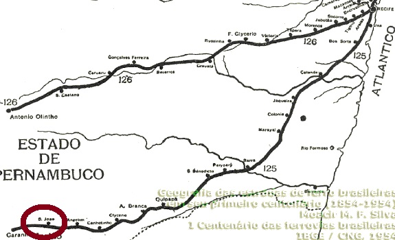
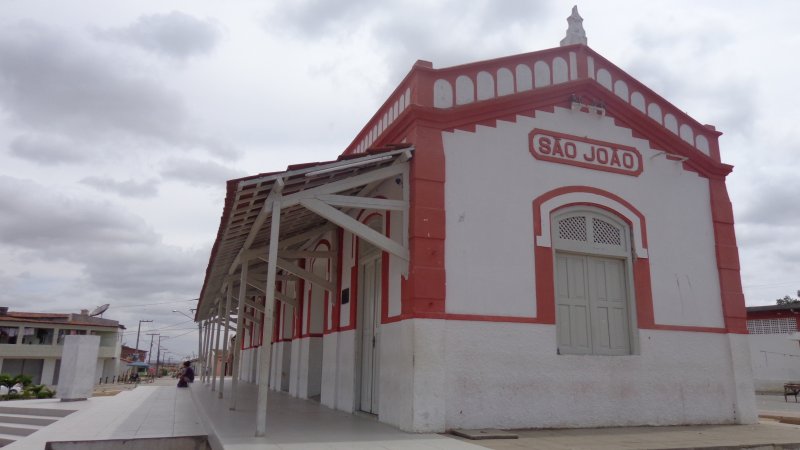
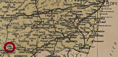
The São João station was inaugurated in July 1887 by the E.F. do Recife ao São Francisco Railway Company in the municipality of Garanhuns. It was located on the so-called Garanhuns junction, about 230 km southwest of the provincial capital Recife. In 1901, the line was taken over by the Great Western Railway and from 1950 until the end of 1971 to the Rede Ferroviária do Nordeste. A settlement grew around the station, which in November 1958 became the municipality of São João. Now the railway tracks have been removed, but the station building has been restored in an exemplary way and serves as a city library:
The station post office was created at the end of October 1889, as can be read in the Postal Report 7/1889 of the following month:
Relatório Postal 7, November 1889
Two weeks later, the Brazilian Empire was history. It is therefore very unlikely that a postmark with an imperial date will appear.
Arthur D. Ribeiro: Estado de Pernambuco, 1924
Anderer Name: São João
São João hieß der Bahnhof, der im Juli 1887 von der E.F. do Recife ao São Francisco Bahngesellschaft im Município von Garanhuns eingeweiht wurde. Er lag auf der so genannten Garanhuns-Abzweigung, ca. 230 km südwestlich der Provinzhauptstadt Recife entfernt. 1901 wurde die Bahnlinie von der Great Western Railway übernommen und ging von 1950 bis zum Betriebsende 1971 zur Rede Ferroviária do Nordeste über. Um den Bahnhof wuchs eine Siedlung, die im November 1958 zum Município von São João aufstieg. Nun sind die Bahnschienen abgerissen, aber das Bahnhofsgebäude wurde mustergültig restauriert und dient heute als Stadtbibliothek:
Das Bahnhofspostamt wurde Ende Oktober 1889 ins Leben gerufen, wie im Postbericht 7/1889 vom folgenden Monat zu lesen ist:
Relatório Postal 7, November 1889
Zwei Wochen danach war das brasilianische Kaiserreich Geschichte. Es ist dadurch sehr unwahrscheinlich, dass ein Poststempel mit imperialem Datum entdeckt wird.
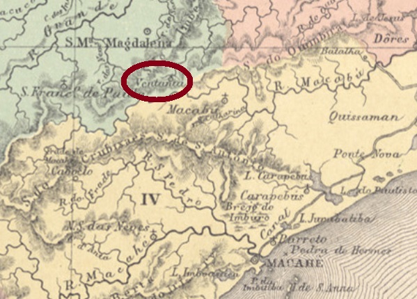
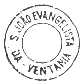
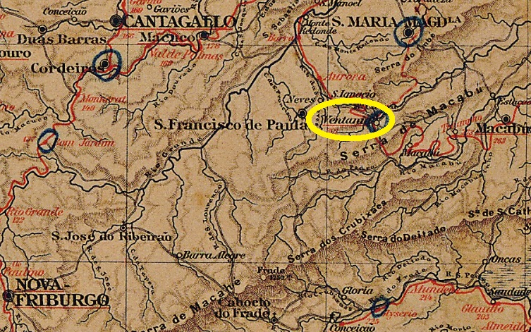
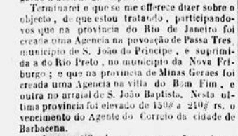
São João Evangelista da Ventania (= of the Strong Winds) was a curato – a church community with priest home – in the municipality of Santa Maria Magdalena, which was located about 240 km northeast of the imperial capital Rio de Janeiro. In June 1892, it rose to a district named Trajano de Moraes. This was a politically influential landowner of the region, who had died in 1911. It became a town in December 1929 and a municipality in March 1938.
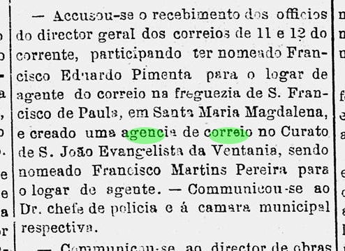
Two creation dates for the local post office have been found. First in January 1876, as can be read in the Rio press:
Diario do Rio de Janeiro, 22 January 1876
Then Paulo Novaes (agenciaspostais.com.br) writes another date in September 1883. This year is confirmed by the Imperial Mail Register (Tabella das Agencias do Correio do Imperio) of 1885. Meanwhile, two postmarks from the imperial period are known: SRJ-1410a has already been presented by Cicero A. Almeida in Carimbos Postais – século XIX (Rio de Janeiro, 1989) under MPT 753:
SRJ-1410a (MPT 753) 1887-1892
From the Márcio Duarte collection comes the probably earlier SRJ-1410b:
SRJ-1410b (MD) 1876ffAlmanak Laemmert ,1892
Textaktualisierung am 13.Oktober 2024
Anderer Name: Trajano de Moraes (1915)
São João Evangelista da Ventania (= der Starken Winde) hieß ein Curato – also eine Kirchengemeide mit Pfarrhaus – im Município von Santa Maria Magdalena, der ca. 240 km nordöstlich der kaiserlichen Hauptstadt Rio de Janeiro entfernt lag. Im Juni 1892 stieg er zum Distrikt im Município von São Francisco de Paula und wechselte 1915 den Namen zu Trajano de Moraes. So hieß ein politisch einflussreicher Großgrundbesitzer der Region, der 1911 verstorben war. Der Ort stieg im Dezember 1929 zur Stadt und im März 1938 zum Município auf.
Es sind zwei Gründungsdaten fürs örtliche Postamt überliefert. Zuerst Im Januar 1876, wie in der Rio-Presse zu lesen ist:
Diario do Rio de Janeiro, 22. Januar 1876
Dann schreibt Paulo Novaes (agenciaspostais.com.br) ein weiteres Datum im September 1883. Dieses Jahr wird durch das Verzeichnis der kaiserlichen Postämter (Tabella das Agencias do Correio do Imperio) von 1885 bestätigt. Inzwischen sind uns zwei Stempel aus der Kaiserzeit bekannt: SRJ-1410a wurde bereits durch Cicero A. Almeida in Carimbos Postais – século XIX (Rio de Janeiro, 1989) unter MPT 753 vorgestellt:
SRJ-1410a (MPT 753) 1887-1892
Aus der Sammlung Márcio Duarte kommt der wohl frühere SRJ-1410b dazu:
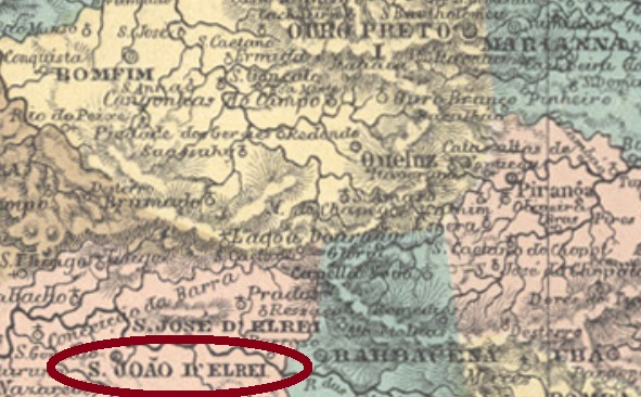
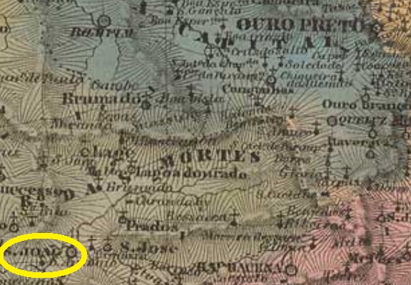
This village was formerly called Arraial do Rio das Mortes and belonged until December 1713 to Vila Rica (later the provincial capital Ouro Preto), from which it was located about 160 km southwest. Then it became the villa of São João d’El-Rei, in honour of King João V (1689-1750), called “o Magnânimo” (= the Magnanime), who ruled Portugal and its colonies from 1706 until his death. Since March 1838, it has been a city.
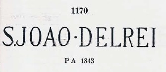
Both Nova Monteiro (Administrações e Agencias Postaes do Brasil Imperio, in Brasil Filatelico/RJ, 1934-5; Reprint SPP 1994-1999) and Paula Sobrinho (Historia Postal de Minas Gerais, Belo Horizonte, 1997) agree that the post office there was created in March 1798. This agency is therefore one of the oldest in Brazil. Four early stamps were found. The first of these, SMG-2365a, is available in black, red, brown and magenta. It was in use until at least 1850, having been already presented by Paulo Ayres (Catalogo de Carimbos Brasil-Império, S. Paulo, 1937, 1942) under No. 1170:
SMG-2365a (P. Ayres 1170, RHM P-MG-58)
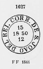
Its successor SMG-2365b was in use from the numeral issue of 1844, and was also shown by Paulo Ayres, now under no. 1627:
SMG-2365b (P. Ayres 1627)
Two stamps in double circle followed: SMG-2365c (image from the internet) is a “French type”, with the inscription S. JOÃO D’EL REY above and the typical star between parentheses below. The dates at the centre go from 1877 to 1888, but sometimes the year is missing. As can be read in the Catálogo Enciclopédico de Selos & História Postal do Brasil (S. Paulo, 1999), there is alledgedly a variant of it with the above inscription ST. JOÃO D’EL REY. SMG-2365d (image from the internet) has above the inscription S. JOÃO d’EL-REI (where the tilde is between A and O) and below (MINAS). The dates at the centre remain between 1890 and 1899.
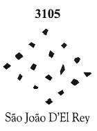
In addition, a mute cancellation from S. João d’El Rei was shown by Paulo Ayres under No. 284 – but allegedly with the wrong toponym of São José del Rey. J. Dingler and K.W. Lopes (Mute Cancellations of the Brazil Empire/ Carimbos Mudos do Brasil Império, BPA, Rio de Janeiro, 2000) corrected it and presented the cancel under BPA 3105:
P. Ayres # 284, BPA 3105 (1878ff)
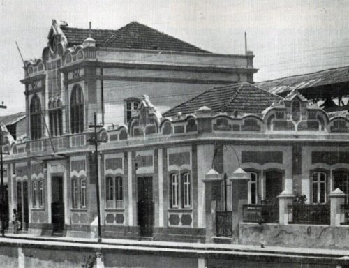
In August 1881, the E.F. Oeste de Minas Railway Company, Paraopeba Line, inaugurated the station of São João d’El Rei. The line changed to the Rede Mineira de Viação in 1931, to the V.F. Centro-Oeste in 1965, to the Rede Ferroviária Federal S.A. in 1975 and to the Ferrovia Centro-Atlântica in 1976 (estacoesferroviarias.com.br).
Unknown photograph (estacoesferroviarias.com.br)
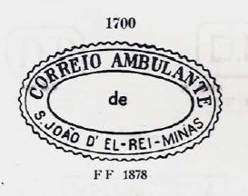
According to Paula Sobrinho (op. cit.) there is also a post office there since September 1882. The first cancel, SMG-2366a, was used in the mail waggon, having been presented by P. Ayres (op. cit.) under No. 1700:
SMG-2366a (P. Ayres 1700)
It was followed by SMG-2366b (Collection Karlheinz Wittig): a double circle with the inscription ESTAÇĀO DE SĀO JOĀO D’EL-REI at the top and a star between parentheses at the bottom. The dates at the centre are from 1886 to 1889. The last of the early station stamps is SMG-2366c (Coll. Karlheinz Wittig): a double circle with the inscription EST. DE S. Jo. DEL REY above and (MINAS) below. It is also in blue and presents dates at the centre from 1889 to 1897.
Villiers de l’Ile Adam: Carta (…) da Provincia de Minas Geraes, 1849
Diese Ortschaft hieß früher Arraial do Rio das Mortes und gehörte bis Dezember 1713 zu Vila Rica (später die Provinzhauptstadt Ouro Preto), von der sie ca. 160 km südwestlich lag. Dann wurde daraus die Villa von São João d’El-Rei, zu Ehren vom König João V (1689-1750), genannt „o Magnânimo“ (= der Großmütige), der von 1706 bis zu seinem Tod Portugal und seine Kolonien regiert hat. Seit März 1838 ist São João d’El Rei eine Stadt.
Sein Nachfolger SMG-2365b war ab der Ziffer-Ausgabe von 1844 in Verwendung und wurde ebenfalls von Paulo Ayres präsentiert, diesmal unter der Nr. 1627:
SMG-2365b (P.Ayres 1627)
Es folgten zwei Stempel in Doppelkreis: SMG-2365c (Abb. aus dem Internet) ist ein „Französischer-Typus“, mit der Inschrift S. JOÃO D‘EL REY oben und dem typischen Stern zwischen Klammern unten. Die Daten in der Mitte gehen von 1877 bis 1888, aber manchmal fehlt die Jahresangabe. Wie im Catálogo Enciclopédico de Selos & História Postal do Brasil (S. Paulo, 1999) zu lesen ist, soll es davon eine Variante mit der Inschrift ST. JOÃO D‘EL REY geben. SMG-2365d (Abb. aus dem Internet) hat oben die Inschrift S. JOÃO d’EL-REI (wobei die Tilde zwischen A und O liegt) und unten (MINAS). Die Daten in der Mitte gehen bisher von 1890 bis 1899.
Ferner wurde ein stummer Stempel aus S. João d’El Rei durch Paulo Ayres unter Nr. 284 bekannt gemacht – allerdings angeblich mit der falschen Ortsangabe von São José del Rey. J. Dingler und K.W. Lopes (Mute Cancellations of the Brazil Empire/ Carimbos Mudos do Brasil Império, BPA, Rio de Janeiro, 2000) haben das richtiggestellt und den Stempel unter BPA 3105 präsentiert:
P. Ayres 284/ BPA 3105, 1878ff
Im August 1881 wurde der Bahnhof São João d’El Rei durch die E.F. Oeste de Minas Gesellschaft, Paraopeba-Linie, eingeweiht. Die Linie wechselte 1931 zur Rede Mineira de Viação, 1965 zur V.F. Centro-Oeste, 1975 zur Rede Ferroviária Federal S.A. und 1976 bis heute zur Ferrovia Centro-Atlântica (estacoesferroviarias.com.br).
Laut Paula Sobrinho (op. cit.) gibt es auch dort seit dem September 1882 ein Postamt. Der erste Stempel, SMG-2366a, wurde im Postwagen benutzt und auch durch P. Ayres (op. cit.) unter Nr. 1700 vorgestellt:
SMG-2366a (P. Ayres 1700)
Ihm folgte SMG-2366b (Samml. Karlheinz Wittig): ein Doppelkreis mit der Inschrift ESTAÇĀO DE SĀO JOĀO D’EL-REI oben und einem Stern zwischen Klammern unten. Die Daten in der Mitte gehen von 1886 bis 1889. Der letzte unter den frühen Bahnhofsstempeln ist SMG-2366c (Samml. Karlheinz Wittig): ein Doppelkreis mit der Inschrift EST. DE S. Jo. DEL REY oben und (MINAS) unten. Er kommt auch in blau vor und hat Daten im Zentrum von 1889 bis 1897.
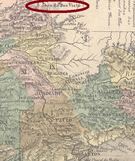
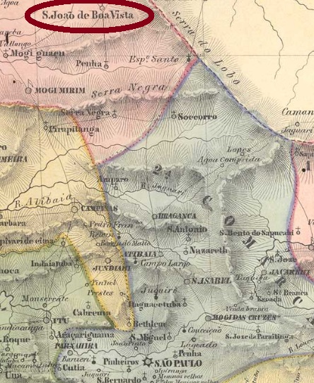
From February 1838, this place was a freguesia in the municipality of Mogy-Mirim, which was located about 200 km north of the provincial capital São Paulo. In March 1859 it rose to a villa, and in April 1880 to a town. A railway station of the Cia. Mogyana Company was inaugurated in October 1886.
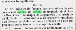
Three different dates were found on the creation of the local post office. According to Nova Monteiro (Administrações e Agencias Postaes do Brasil Imperio, in Brasil Filatelico/RJ, 1934-5; Reprint SPP 1994-1999) there was a post office Boa Vista in São Paulo founded in October 1829, which seems rather unrealistic. The same Nova Monteiro calls another creation in February 1849, now under the name of Sao João da Boa Vista. Then, in April 1849, the press from Rio reported again the creation of this post office:
Diario do Rio de Janeiro, May 8, 1849
Two postmarks of the imperial period are available, but not the oldest. SSP-1160b (Coll. Fuad Ferreira Fo.) has a double circle with the inscription S. J. DA BÔA VISTA above. It is also available in turquoise blue and shows in its middle dates from 1880 to 1890. SSP-1160c (Coll. Marcio Protzner) is a railway stamp. In the double circle, the above inscription is now S. JOĀO DA BOA VISTA, while one can read (C.A.) below, for Railway Mail (Correio Ambulante). Dates at the centre: 1886 to 1890.
Villiers de l’Ile Adam: Carta (…) da Provincia de São Paulo, 1847
Anderer Name: Boa Vista
Dieser Ort war ab Februar 1838 eine Freguesia im Município von Mogy-Mirim, die gut 200 km nördlich der Provinzhauptstadt São Paulo entfernt lag. Im März 1859 stieg er zur Villa, und im April 1880 zur Stadt. Ein Bahnhof der Cia. Mogyana Eisenbahngesellschaft wurde im Oktober 1886 eingeweiht.
Zur Entstehung des örtlichen Postamts wurden drei verschiedene Daten gefunden. Laut Nova Monteiro (Administrações e Agencias Postaes do Brasil Imperio, in Brasil Filatelico/RJ, 1934-5; Reprint SPP 1994-1999) war ein Postamt Boa Vista bereits im Oktober 1829 gegründet, was eher unrealistisch erscheint. Derselbe Nova Monteiro nennt eine weitere Gründung im Februar 1849, nun unter dem Namen São João da Boa Vista. Dann meldete die Presse aus Rio ein neues Postamt São João da Boa Vista im April 1849:
Diario do Rio de Janeiro, 08.05.1849
Zwei Poststempel der Kaiserzeit sind vorhanden, wohl aber nicht der Älteste. SSP-1160b (Samml. Fuad Ferreira Fo.) hat einen Doppelkreis mit der Inschrift S. J. DA BÔA VISTA oben. Er kommt auch in türkisblau vor und zeigt in seiner Mitte Daten von 1880 bis 1890. SSP-1160c (Samml. Marcio Protzner) ist ein Eisenbahnstempel. Im Doppelkreis lautet die obige Inschrift nun S. JOĀO DA BOA VISTA, während unten (C.A.) zu lesen ist, für Correio Ambulante. Daten in der Mitte von 1886 bis 1890.
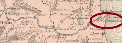
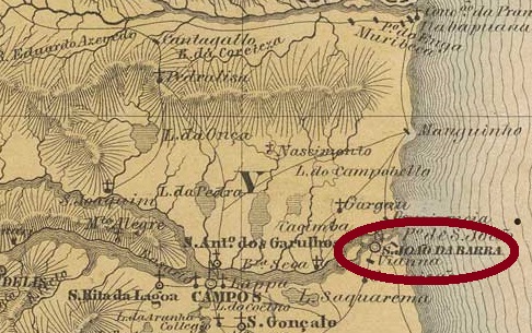
This village was from January 1756 a freguesia called São João da Praia (= on the beach), it belonged to the villa of Parahyba do Sul and was located on the delta of the river of the same name, about 300 km northeast of the capital Rio de Janeiro. In January 1833, it rose to the villa of São João da Barra (= of the estuary), and in June 1850 to a town.
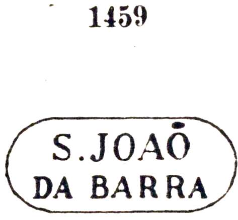
According to Nova Monteiro (Administrações e Agencias Postaes do Brasil Imperio, in Brasil Filatelico/RJ, 1934-5; Reprint SPP 1994-1999), there is a post office there since March 1829, whereby the year 1830 can be read in the Imperial Mail Register (Tabella das Agencias do Correio do Imperio ) of 1885. The first years of operation of the agency were probably very calm, since the earliest postal letters found so far date from about 1844. The oldest cancel SRJ-0940a has already been presented by Paulo Ayres under No. 1459. It occurs also in red and remained in use until at least 1877:
SRJ-0940a (Paulo Ayres 1459)
It was followed by SRJ-0940b (Coll. José A. Junges): a double circle with inscription S. JOAO DA BARRA above. The dates at the centre were found for the period 1876-1889. Then came SRJ-0940c (Coll. Paulo Novaes), which is very similar to his predecessor, however, one sees a small stroke as a tilde between A and O at JOAO, and the word DA is written in smaller letters than usual. The only copy has a date from 1891 at the centre.
Villiers de l’Ile Adam: Carta (…) da Provincia do Rio de Janeiro, 1850
Anderer Name: São João da Praia
Diese Ortschaft war ab Januar 1756 eine Freguesia mit dem Namen São João da Praia (= des Strandes), gehörte der Villa von Parahyba do Sul und lag am Delta des gleichnamigen Flusses, über 300 km nordöstlich der Hauptstadt Rio de Janeiro. Im Januar 1833 stieg sie zur Villa von São João da Barra (= der Mündung), und im Juni 1850 zur Stadt.
Laut Nova Monteiro (Administrações e Agencias Postaes do Brasil Imperio, in Brasil Filatelico/RJ, 1934-5; Reprint SPP 1994-1999) gibt es dort ein Postamt seit März 1829, wobei im Verzeichnis der kaiserlichen Postämter (Tabella das Agencias do Correio do Imperio ) von 1885 die Jahresangabe 1830 zu lesen ist. Die ersten Betriebsjahre der Agentur waren wohl sehr ruhig, da die frühesten Postbelege bisher aus ca. 1844 stammen. Der älteste Stempel SRJ-0940a wurde bereits durch Paulo Ayres unter Nr. 1459 vorgestellt. Er kommt auch in Rot vor und blieb bis mindestens 1877 im Gebrauch:
SRJ-0940a (Paulo Ayres 1459)
Ihm folgte SRJ-0940b (Samml. José A. Junges): ein Doppelkreis mit Inschrift S. JOAO DA BARRA oben. Die Daten im Inneren kommen aus dem Zeitraum 1876-1889. Danach kam SRJ-0940c (Samml. Paulo Novaes), der sehr ähnlich wie sein Vorgänger ist, allerdings sieht man eine kleine Balke als Tilde zwischen A und O bei JOAO, und das Wort DA steht in kleineren Buchstaben als sonst. Das einzige Exemplar trägt ein Datum aus 1891 in der Mitte.
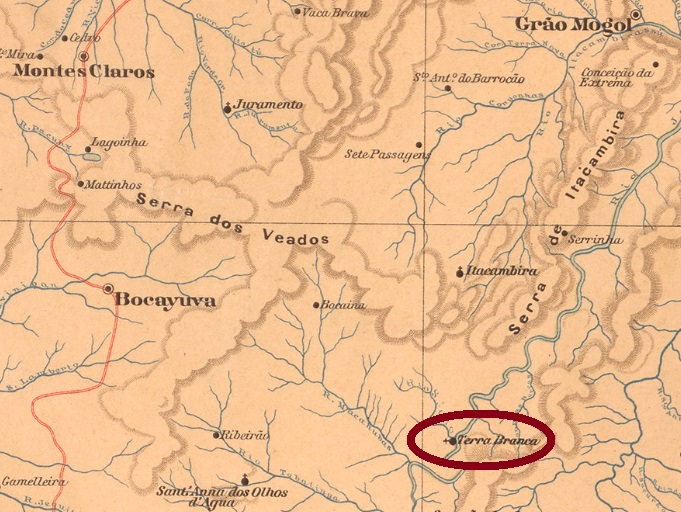
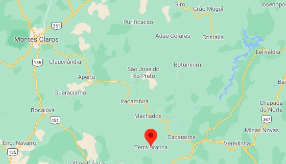
This village was a district in the municipality of Grão Mogol from July 1868 and was located on the north bank of the Jequitinhonha River, about 550 km north of the provincial capital Ouro Preto. Since then, it has changed the municipality three times: in November 1873 to the newly founded Municipality of Jequitahy, in October 1881 as a freguesia of Montes Claros, and around 1894 to the new municipality of Bocayuva, a successor to the municipality of Jequitahy. Since August 1911, the village has been bearing the simplified Name Terra Branca.
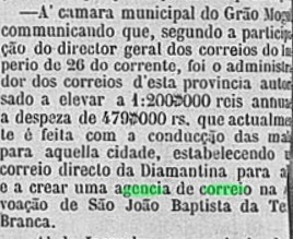
According to Paula Sobrinho (História Postal de Minas Gerais, Belo Horizonte, 1997), the local post office was established in June 1873. This is reported by the regional press:
Diario de Minas, April 17, 1873
Two imperial postmarks in double circle were found: SMG-2350a (Coll. Henrique B. Ferreira) has the inscription S.J.B. DA TERRA BRANCA, dated 1877 at the centre. SMG-2350b (Coll. José A. Junges) has the inscription S. JOÃO BAPTA DA TERRA BRANCA above and an – unfortunately illegible – ornament below. The only copy bears a date from 1886 at the centre.
Google Maps
Aktualisiert am 7. Juli 2021
Anderer Name: Terra Branca (1911)
Diese Ortschaft war ab Juli 1868 ein Distrikt im Município von Grão Mogol, und lag am Nordufer des Flusses Jequitinhonha, gut 550 km nördlich der Provinzhauptstadt Ouro Preto gelegen. Danach wechselte er dreimal die Zuständigkeit: im November 1873 zum neu gegründeten Município de Jequitahy, im Oktober 1881 als Freguesia von Montes Claros und ca. 1894 zum neuen Município von Bocayuva, einem Nachfolger der Gemeinde Jequitahy. Seit August 1911 trägt der Ort den vereinfachten Namen Terra Branca.
Laut Paula Sobrinho (História Postal de Minas Gerais, Belo Horizonte, 1997) entstand das örtliche Postamt im Juni 1873. Dies bestätigt die regionale Presse:
Diario de Minas, 17. April 1873
Zwei kaiserliche Poststempel im Doppelkreis wurden gefunden: SMG-2350a (Samml. Henrique B. Ferreira) hat oben die Inschrift S.J.B. DA TERRA BRANCA, datiert 1877 im Inneren. SMG-2350b (Samml. José A. Junges) hat nun die Inschrift S. JOĀO BAPTA DA TERRA BRANCA oben und einem – leider unleserliches – Ornament unten. Das einzige Exemplar trägt ein Datum aus 1886 in der Mitte.
Other names: São João Baptista, Itamarandiba (1923)
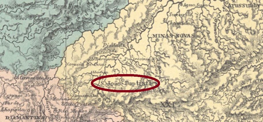
This was since April 1840 a parish in the municipality of Minas Novas, more than 450 km north of the provincial capital Ouro Preto. In September 1862 it became a villa in its own municipality, which was elevated to a town in September 1877. Since September 1923, the municipality has been called Itamarandiba. In the Indian language, this means “rolling gravel”.
Three dates were found for the local post office, a sure indication that it was closed in between. It is said to have been the first time in 1845, as reported by the Pernambuco press:
Diario de Pernambuco, 5 February 1845
The second creation date is in June 1855, as Aureo G. Santos reports in Agéncias de Correio Criadas e Suprimidas 1851, 1855, 1856 e 1857 (Brasil Filatélico 181, Rio de Janeiro, 1977):
Aureo G. Santos (op. cit.)
Finally, Paula Sobrinho writes a date from December 1884 in Historia Postal de Minas Gerais (Belo Horizonte, 1997). Two early postmarks have been found, the second of which has not yet been definitively confirmed. SMG-3450b (Coll. José A. Junges) probably comes from the second period: a double circle with the inscription S. J. B. DE MINAS NOVAS above. The only specimen bears a date from 1877 at the centre. SMG-3450c (Coll. Márcio Protzner) could also belong to São João Baptista of Bom Successo (see SMG-2360): a double circle with the inscriptions S. Jo. BAPTISTA above and (MINAS) below. The only copy was seen in purple and has a date from 1902.
Villiers de l’Ile Adam: Carta (…) da Provincia de Minas Geraes, 1849
Andere Namen: São João Baptista, Itamarandiba (1923)
Das war seit April 1840 eine Pfarrei im Município von Minas Novas, die über 450 km nördlich der Provinzhauptstadt Ouro Preto entfernt lag. Im September 1862 wurde daraus eine Villa im eigenen Município, die im September 1877 zur Stadt erhoben wurde. Seit September 1923 heißt die Gemeinde Itamarandiba. In der Indianersprache bedeutet das „rollender Kies“.
Es wurden drei Daten fürs örtliche Postamt gefunden, ein sicheres Indiz dafür, dass es zwischendurch geschlossen war. Erstmals soll es am Anfang 1845 gewesen sein, wie die Presse aus Pernambuco berichtet:
Schließlich schreibt Paula Sobrinho in Historia Postal de Minas Gerais (Belo Horizonte, 1997) ein Datum aus Dezember 1884. Zwei frühe Poststempel wurden gefunden, wobei der zweite noch nicht endgültig bestätigt ist. SMG-3450b (Samml. José A. Junges) stammt wohl von der zweiten Betriebsperiode: ein Doppelkreis mit der Inschrift S. J. B. DE MINAS NOVAS oben. Das einzige Exemplar trägt ein Datum aus 1877 in der Mitte. SMG-3450c (Samml. Márcio Protzner) könnte vielleicht auch von São João Baptista im Bom Successo (SMG-2360) sein: ein Doppelkreis mit den Inschriften S. Jo. BAPTISTA oben und (MINAS) unten. Das einzige Stempelexemplar kommt in lila vor und hat ein Datum aus 1902.
The chapel, built in December 1815 in the freguesia of Triumpho, was located about 130 km south of the later provincial capital of Porto Alegre. The village rose to a freguesia in 1854, and to a villa in April 1864. The word Camaquan (or Camaquã) comes from the Tupi-Guarani language and is said to mean strong current.
According to Nova Monteiro (Administrações e Agencias Postaes do Brasil Imperio, in Brasil Filatelico/RJ, 1934-5; Reprint SPP 1994-1999) the local post office was established in October 1860. Two early cancels were found, but probably not the oldest. SRS-0325b (Coll. José A. Junges) consists of a simple double circle with the inscription S. J.B. DE CAMAQUAN above. The dates at the centre were found so far for the period 1878-1881. His successor SRS-0325c (Coll. José A. Junges) is very similar, but here the letters are much higher and narrower. Dates from 1890.
Villiers de l’Ile Adam: Carta (…) da Provincia de São Pedro do Sul, 1847
Andere Namen: São João de Camaquan, Camaquã
São João Baptista de Camaquan hieß die Kapelle, die im Dezember 1815 in der Freguesia von Triumpho erbaut wurde, knapp 130 südlich von der späteren Provinzhauptstadt Porto Alegre gelegen. Der Ort stieg 1854 zur Freguesia auf, und im April 1864 zur Villa. Das Wort Camaquan (oder Camaquã) kommt aus der Tupi-Guarani-Sprache und soll Starke Strömung bedeuten.
Laut Nova Monteiro (Administrações e Agencias Postaes do Brasil Imperio, in Brasil Filatelico/RJ, 1934-5; Reprint SPP 1994-1999) entstand das örtliche Postamt im Oktober 1860. Zwei frühe Stempel sind vorhanden, allerdings wohl nicht der älteste. SRS-0325b (Samml. José A. Junges) besteht aus einem einfachen Doppelkreis mit der Inschrift S. J. B. DE CAMAQUAN oben. Die Daten in der Mitte wurden bisher für den Zeitraum 1878-1881 gefunden. Sein Nachfolger SRS-0325c (Samml. José A. Junges) ist sehr ähnlich, aber hier sind die Buchstaben wesentlich höher und schmäler. Bisherige Daten aus 1890.